Download presentation
Presentation is loading. Please wait.

1
C-Nav GPS System GPS Services Group www.cctechnol.com/cnav
C&C Technologies, Inc.,

2
The figure shows an overview of the StarFire WADGPS network
The figure shows an overview of the StarFire WADGPS network. At a conceptual level, it is similar to other wide-area DGPS systems (S.B.A.S. – Satelite Based Augmentation Systems) such as : WAAS - Wide Area Augmentation System (FAA North America) EGNOS – European Geo-stationary Navigation Overlay System MSAS – Multifunctional transport Satellite-based Augmentations System (Japan) SNAS – Satellite Navigation Augmentation System (China) GRAS – Ground-based Regional Augmentation System (Australia – VHF) For the RTG network, another set of reference/monitor sites are distributed across the entire world (sites in red). For the WCT networks, a number of reference/monitor sites are distributed across the continental U.S., Europe, South America and Australia. (sites in green) Each reference site sends dual frequency code and phase observables for all GPS satellites in view as well as system integrity information to two redundant network processing hubs (NPH) via terrestrial communication links (sites in blue) in North America (Redondo Beach, Ca & Moline, IL).
 such as : WAAS - Wide Area Augmentation System (FAA North America) EGNOS – European Geo-stationary Navigation Overlay System. MSAS – Multifunctional transport Satellite-based Augmentations System (Japan) SNAS – Satellite Navigation Augmentation System (China) GRAS – Ground-based Regional Augmentation System (Australia – VHF) For the RTG network, another set of reference/monitor sites are distributed across the entire world (sites in red). For the WCT networks, a number of reference/monitor sites are distributed across the continental U.S., Europe, South America and Australia. (sites in green) Each reference site sends dual frequency code and phase observables for all GPS satellites in view as well as system integrity information to two redundant network processing hubs (NPH) via terrestrial communication links (sites in blue) in North America (Redondo Beach, Ca & Moline, IL).")
3
C-Nav Control Display Unit (CnC D.U.)
C-Nav[RM] GPS System C-Nav GPS Receiver C-Nav Control Display Unit (CnC D.U.) The C-Nav system provides the user with industry standard NMEA sentence information. These are:- GGA - Global Positioning System Fix Data GLL - GPS Latitude and Longitude Data GSA - GPS Mode, Satellites used for navigation, and DOP Data GST - GPS Satellites Position Error Statistics (RAIM compliance) RMC - GPS Recommended Minimum Specific Data VTG - GPS Velocity, Track made good and Ground speed Data ZDA - GPS UTC Date & Time Data In addition, the C-Nav system provides additional NMEA sentence information in the form of ‘proprietary’ messages, as follows:- NAVQ - StarFire Navigation Quality NETQ - StarFire Network Quality ( to be implemented ) RXQ - StarFire Correction Signal Quality SATS - GPS Dual Frequency (L1/L2) Satellites in view (similar to GSV message that only provide L1 frequency signal strength information). Interconnect Cable
 The C-Nav system provides the user with industry standard NMEA sentence information. These are:- GGA - Global Positioning System Fix Data. GLL - GPS Latitude and Longitude Data. GSA - GPS Mode, Satellites used for navigation, and DOP Data. GST - GPS Satellites Position Error Statistics (RAIM compliance) RMC - GPS Recommended Minimum Specific Data. VTG - GPS Velocity, Track made good and Ground speed Data. ZDA - GPS UTC Date & Time Data. In addition, the C-Nav system provides additional NMEA sentence information in the form of ‘proprietary’ messages, as follows:- NAVQ - StarFire Navigation Quality. NETQ - StarFire Network Quality ( to be implemented ) RXQ - StarFire Correction Signal Quality. SATS - GPS Dual Frequency (L1/L2) Satellites in view (similar to GSV message that only provide L1 frequency signal strength information). Interconnect Cable.")
4
C-Nav[RM] is? A Worldwide ‘global’ GPS solution (RTG)
Provides deci-meter accuracy and stability Simple ‘plug-n-play’ installation and use Integrated ‘mast-head’ package minimizes equipment hardware requirements Subscription Service activation and deactivation for long or short term usage ‘Regional’ backup solutions (WCT & SBAS)
![C-Nav[RM] is A Worldwide ‘global’ GPS solution (RTG)](http://slideplayer.com/slide/7562527/24/images/4/C-Nav%5BRM%5D+is+A+Worldwide+%E2%80%98global%E2%80%99+GPS+solution+%28RTG%29.jpg "Provides deci-meter accuracy and stability. Simple ‘plug-n-play’ installation and use. Integrated ‘mast-head’ package minimizes equipment hardware requirements. Subscription Service activation and deactivation for long or short term usage. ‘Regional’ backup solutions (WCT & SBAS)")
5
Global Corrected GPS via StarFire Network
North & Central America (RTG, WCT, SBAS) Western Europe / Mediterranean Sea (RTG, WCT, SBAS) Far East Region (RTG, SBAS**) Australia (RTG, WCT) South America (RTG) Eastern Europe / Mediterranean & Black Sea (RTG, SBAS) African Continent (RTG) Middle East, & Asian Continent (RTG) Atlantic, Indian and Pacific Oceans (RTG) ** Waiting on MSAS RTG corrections are available ‘globally’ within the Inmarsat communication satellite signal footprint (72deg N to 72deg South) WCT corrections are available in North America, South America, Northern Europe and Australia. SBAS corrections are available in North America (WAAS – mid 2003) and North West Europe (EGNOS – mid 2004) MSAS corrections will be available for Japan / Far East when operational
 Western Europe / Mediterranean Sea (RTG, WCT, SBAS) Far East Region (RTG, SBAS**) Australia (RTG, WCT) South America (RTG) Eastern Europe / Mediterranean & Black Sea (RTG, SBAS) African Continent (RTG) Middle East, & Asian Continent (RTG) Atlantic, Indian and Pacific Oceans (RTG) ** Waiting on MSAS. RTG corrections are available ‘globally’ within the Inmarsat communication satellite signal footprint (72deg N to 72deg South) WCT corrections are available in North America, South America, Northern Europe and Australia. SBAS corrections are available in North America (WAAS – mid 2003) and North West Europe (EGNOS – mid 2004) MSAS corrections will be available for Japan / Far East when operational.")
6
America’s RTG Performance
Cumulative RTG Horizontal Solution performance analysis for January 2004 for the Americas region The 95% confidence horizontal accuracy is 25 centimeters The 1-sigma horizontal value is <10cms

7
Europe-Africa RTG Performance
Cumulative RTG Horizontal Solution performance analysis for January 2004 for the Europe Africa region The 95% confidence horizontal accuracy is 22 centimeters The 1-sigma horizontal value is <10cms

8
Asia-Australia RTG Performance
Cumulative RTG Horizontal Solution performance analysis for January 2004 for the Asia-Australia region The 95% confidence horizontal accuracy is ~25 centimeters The 1-sigma horizontal value is ~10cms

9
GcGPS Architecture Global network of dual frequency GPS reference receivers which transmit their RAW observables to processing / distribution hubs (NPH) Wide area communications used to broadcast corrections to users (StarFire) Dual frequency GPS navigation receivers combined with wide area communication receiver Measure / model key error sources (SV clock, orbit, local observed ionosphere, local troposphere)
 Wide area communications used to broadcast corrections to users (StarFire) Dual frequency GPS navigation receivers combined with wide area communication receiver. Measure / model key error sources (SV clock, orbit, local observed ionosphere, local troposphere)")
10
Dual Frequency GcGPS Performance and Limitations
Decimeter level accuracy over very large areas (regional, continental, global) Initialization time: 15 minutes to one hour (final accuracy) Very low position drift rate in steady state Limitations Requires communication link to receive WADGPS corrections (sat. comm., other) Potentially lengthy initialization time
 Initialization time: 15 minutes to one hour (final accuracy) Very low position drift rate in steady state. Limitations. Requires communication link to receive WADGPS corrections (sat. comm., other) Potentially lengthy initialization time.")
11
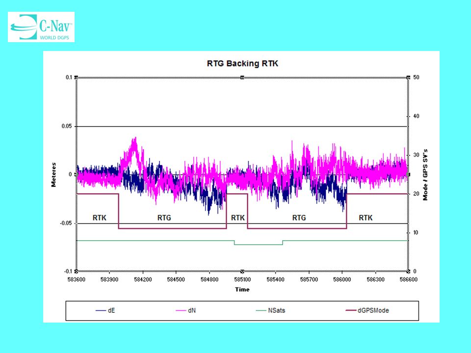
Recent Improvements L1 phase navigation ‘smart’ position updates
Upstream (50Hz) measurement processing restructure L1 phase nav. residual editing and cycle slip detection restructure RTG backing RTK
 measurement processing restructure. L1 phase nav. residual editing and cycle slip detection restructure. RTG backing RTK.")
12
Onshore GPS Stress Testing

13
A - Shading Areas - B

14
RTG w/o L1Pnav

15
RTG with L1Pnav

16
Overlay

17
Offshore Stress Testing

18
Vessel Setup

19
C-Nav Testing

20
C-Nav Testing

21
C-Nav Testing

22
C-Nav[2050] System Work is underway to provide the next generation (or level) of C-Nav GPS product that will allow high-accuracy Real-Time Kinematic (RTK) capability for users and customers whilst still providing StarFire PVT solutions. The latest development provides for RTK precision when operated in the ‘local area’ of an RTK base reference station but can automatically revert to ‘global’ RTG corrections (or regional WCT corrections) when outside of any RTK coverage. Note: S.B.A.S. capability is also retained.
![C-Nav[2050] System](http://slideplayer.com/slide/7562527/24/images/22/C-Nav%5B2050%5D+System.jpg "Work is underway to provide the next generation (or level) of C-Nav GPS product that will allow high-accuracy Real-Time Kinematic (RTK) capability for users and customers whilst still providing StarFire PVT solutions. The latest development provides for RTK precision when operated in the ‘local area’ of an RTK base reference station but can automatically revert to ‘global’ RTG corrections (or regional WCT corrections) when outside of any RTK coverage. Note: S.B.A.S. capability is also retained.")
23
RTK and GcGPS Synergies
Q: If both RTK and dual frequency Starfire Wide Area DGPS (GcGPS) navigation solutions are available in the same system hardware/firmware, can they be combined to provide better performance? A: Yes
 navigation solutions are available in the same system hardware/firmware, can they be combined to provide better performance A: Yes.")
24
Convential RTK Systems Typical Architecture
RTK base station: stationary, dual frequency GPS receiver generates local corrections Terrestrial communications link used to transmit base station corrections to the RTK rover RTK rover (navigator): dual frequency GPS receiver receives base station corrections and resolves carrier phase, integer ambiguities for satellites in view.
: dual frequency GPS receiver receives base station corrections and resolves carrier phase, integer ambiguities for satellites in view.")
25
Convential RTK Systems Performance and Limitations
Centimeter level accuracy (1cm + 1ppm) Effectively zero position drift rate Initialization time: a few seconds to a few minutes Limitations Requires local base station and communication link to receive RTK correction data. Operational area limited by range to base station Range of communication link Range limit for ambiguity resolution
 Effectively zero position drift rate. Initialization time: a few seconds to a few minutes. Limitations. Requires local base station and communication link to receive RTK correction data. Operational area limited by range to base station. Range of communication link. Range limit for ambiguity resolution.")
26
Exploiting RTK and WADGPS Synergies
Initializing the WADGPS solution with RTK Coasting’ through RTK outages using Carrier Phase RTG measurements Re-initializing RTK using the WADGPS solution

27
The Problem

30
Questions? Refer to: http://www.cctechnol.com/cnav
for additional material and information The C&C Technologies C-Nav WEB Site has additional information and material (Manuals, Papers, Related Links etc..).
.")
Similar presentations

: C-Nav GPS System>")

>")


 & Geographic Information Systems (GIS) RESOURCE INVENTORY Soil Survey National Resources Inventory (NRI) Wetlands.>")


 work>")


