Download presentation
Presentation is loading. Please wait.

1
ATMOSPHERIC CORRECTION – HYPERSPECTRAL DATA Course: Special Topics in Remote Sensing & GIS Mirza Muhammad Waqar Contact: mirza.waqar@ist.edu.pk +92-21-34650765-79 EXT:2257 RG712

2
Outlines Hyperspectral Data Hyperspectral vs Multispectral Data Analysis Hyperspectral Mapping Techniques Spectral Angle Mapper Matched Matching Spectral Feature Fitting Binary Encoding (BE) Complete Linear Spectral Unmixing Match Filtering
 Complete Linear Spectral Unmixing Match Filtering")
3
Format of Remote Sensing Image Data BSQ => Band Sequential Image data (pixel number and line number) of each band are separately arranged BIL => Band Interleaved by Line Line data are arranged in the order of band number and repeated with respect to line number BIP => Band interleaved by pixel A set of multi-band data with respect to each pixel arranged spatially by pixel number and line number
 of each band are separately arranged BIL => Band Interleaved by Line Line data are arranged in the order of band number and repeated with respect to line number BIP => Band interleaved by pixel A set of multi-band data with respect to each pixel arranged spatially by pixel number and line number")
5
For colour image output, BSQ format would be convenient because three bands will be assigned to R(red), G(green) and B(blue). However BIP format would be better for classification by a maximum likelihood classifier because multi-band data are required pixel by pixel for the multi-variable processing. BIL would be a compromise between BSQ and BIP. Format of Remote Sensing Image Data

6
Re-calibration of Hyperspectral Data 1. VNIR Bands (1-70) FIX(100.0*(float(b1)/40.0)+0.5) This will be the VNIR bands converted to absolute radiance and scaled by 100. The output file type is BSQ. 2. SWIR Bands (71-242) FIX(100.0*(float(b2)/80.0)+0.5) This will be the SWIR bands converted to absolute radiance and scaled by 100. Again the output type is BSQ.
 FIX(100.0*(float(b1)/40.0)+0.5) This will be the VNIR bands converted to absolute radiance and scaled by 100. The output file type is BSQ. 2. SWIR Bands (71-242) FIX(100.0*(float(b2)/80.0)+0.5) This will be the SWIR bands converted to absolute radiance and scaled by 100. Again the output type is BSQ..")
7
3. Combine VNIR and SWIR Radiance After successful conversion, VNIR and SWIR Radiance files will be combine together for further processing 4. Attach the Wavelength Header Normally while conversion, wavelength information is lost By editing header file of radiance, wavelength can be attach again Re-calibration of Hyperspectral Data

8
Fixing Bad Pixels In pushbroom sensors such as Hyperion, poorly calibrated detectors in the VNIR or SWIR arrays will leave vertical stripes or ‘streaks’ in certain pixels of an image bands. The most extreme cases of these pixels contain little or no valid data and these are identified as bad bands.

9
Fixing Bad Pixels In level 1B1 processing => Interpolation to fill bad data values In level 1R processing => List of bad data values is provided with the data Note: Due to the geometry fix between the VNIR and SWIR bands the last pixel is left blank for all SWIR bands.

10
Criteria for Selection of bad bands Band 1-7, 58-76, 225-242 zeroed bands Atmospheric Water vapour bands: 121-122, 126-127, 167-178 and 224 bad bands These bands contain little or no information about the surface. Zeroed and bad bands will be ignored for further processing. It is recommended to make a separated image of good bands, it will reduce data volume and speed up the processing.

11
Fix Out of Range Data During re-scaling of the signed integer data to radiance times 100, some bright features like cloud tops cross the max data value limit. In order to fix this issue, an offset of -1000 can be applied.

12
Fixing Outlier Pixels Presence of outliers in the data will affect the column statistics for data bands and hence influence the destreaking based on statistical balancing. Median and Mean Absolute Derivation (MAD) Use to fix outlier Detecting outliers and replacing them with neighbour median
 Use to fix outlier Detecting outliers and replacing them with neighbour median.")
13
Median and Mean Absolute Derivation (MAD) 1. Global Method Weather the absolute value of difference of pixel with the median of the band is more that a given fraction of the band MAD. 2. Local/Global Method Absolute value of the difference of pixel with the median in a local neighbour is more than a given fraction of the band MAD. 3. Local Method Absolute value of the difference of the pixel with the median in a local neighbour hood is more than a given fraction of MAD in the same LOCAL neighbourhood.

14
Streaking

15
Atmospheric Correction Model ACORN (Atmospheric Correction Now) Input radiance image (W/m 2 sr/µm) Image data must be 16 bit Only accept BIL or BIP format Ancillary Data Orientation Parameters Sensor Altitude Date & Time Water Vapour Amount Visibility
 Input radiance image (W/m 2 sr/µm) Image data must be 16 bit Only accept BIL or BIP format Ancillary Data Orientation Parameters Sensor Altitude Date & Time Water Vapour Amount Visibility")
16
FLAASH (Fas Line-of-Sight Atmospheric Analysis of Spectral Hupercube)
")
17
1. Input Radiance Image Input image must have a BIL or BIP interleave. Should contain Hyperspectral radiance data scaled into 16 bit Scale factor should be chosen such that the input image divided by the scale factor covert 16 bit data to floating point radiance. If the image is already in µW/cm 2 /nm/sr, the gain value for each band will be 1. In our case its unit is W/cm 2 /µm/sr 10 W/m 2 /µm/sr = 1 µW/cm 2 /nm/sr

18
2. Scene and Sensor Information 1. Scene center location 2. Sensor type 3. Sensor altitude 4. Ground elevation 5. Flight date 6. Flight time

19
3. Atmospheric Model 1. Sub Arctic Winter 2. Mid Latitude Winter 3. US Standard 4. Sub Arctic Summer 5. Mid Latitude Summer 6. Tropical

20
3. Atmospheric Model

22
4. Aerosol Model 1. No Aerosol 2. Rural 3. Maritime 4. Urban 5. Topographic

23
5. Aerosol Retrieval Aerosol Retrieval This option allows the retrieval of aerosols and estimation of a scene average visibility using image dark pixels. Initial Visibility Value An estimate of visibility (in kilometers) at the time of acquisition must be provided. This value will be used if user will select don’t retrieve aerosol
 at the time of acquisition must be provided. This value will be used if user will select don’t retrieve aerosol.")
24
Spectral Polishing Spectral polishing is a post processing option for smoothing the output reflectance image. Residual noise and artifacts are reduced to make the spectra appear more like the true spectra of the surface. A value of 9 for width is recommended for typical 10 nm-resolution hyperspectral sensor. 5. Aerosol Retrieval

25
6. FLAASH Advanced Settings

26
Questions & Discussion

Similar presentations
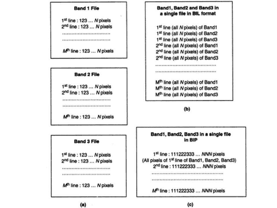
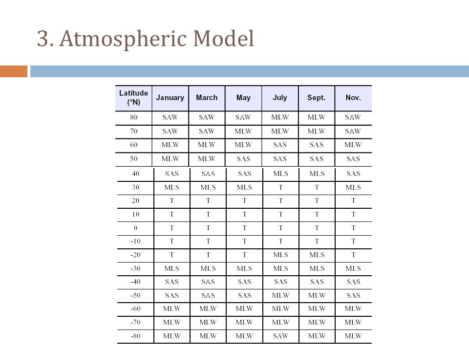

 Image Quality Assessment Radiometric Correction Geometric Correction Image Classification Introduction.>")


 using Hyperion sensor. INTEREST POINTS FOR HYPERSPECTRAL IMAGES Amit Mukherjee 1, Badrinath Roysam 1,>")


