Download presentation
Presentation is loading. Please wait.

1
WRF Modeling System Overview
Jimy Dudhia

2
What is WRF? WRF: Weather Research and Forecasting Model
Used for both research and operational forecasting It is a supported “community model”, i.e. a free and shared resource with distributed development and centralized support Its development is led by NCAR, NOAA/ESRL and NOAA/NCEP/EMC with partnerships at AFWA, FAA, and collaborations with universities and other government agencies in the US and overseas

3
What is ARW? WRF has two dynamical cores: The Advanced Research WRF (ARW) and Nonhydrostatic Mesoscale Model (NMM) Dynamical core includes mostly advection, pressure-gradients, Coriolis, buoyancy, filters, diffusion, and time-stepping Both are Eulerian mass dynamical cores with terrain-following vertical coordinates ARW support and development are centered at NCAR/MMM NMM development is centered at NCEP/EMC and support is provided by NCAR/DTC This tutorial is for the ARW core Both are downloadable in the same WRF tar file Physics, the software framework, and parts of data pre- and post-processing are shared between the dynamical cores

4
What are ARW and NMM? The Advanced Research WRF (ARW) and Nonhydrostatic Mesoscale Model (NMM) are dynamical cores Dynamical core includes mostly advection, pressure-gradients, Coriolis, buoyancy, filters, diffusion, and time-stepping Both are Eulerian mass dynamical cores with terrain-following vertical coordinates ARW support and development are centered at NCAR/MMM NMM development is centered at NCEP/EMC and support is provided by NCAR/DTC This tutorial is for both dynamical cores Both are downloadable in the same WRF tar file Physics, the software framework, and parts of data pre- and post-processing are shared between the dynamical cores

5
WRF as a Community Model
Version 1.0 WRF was released December 2000 Version 2.0: May 2004 (NMM added, EM nesting released) Version 2.1: August 2005 (EM becomes ARW) Version 2.2: December 2006 (WPS released) Version 3.0: April 2008 (includes global ARW version) Version 3.1: April 2009 Version August 2009 Version 3.2: just released in April 2010
 Version 2.1: August 2005 (EM becomes ARW) Version 2.2: December 2006 (WPS released) Version 3.0: April 2008 (includes global ARW version) Version 3.1: April Version August Version 3.2: just released in April")
6
What can WRF be used for? ARW and NMM
Atmospheric physics/parameterization research Case-study research Real-time NWP and forecast system research Data assimilation research Teaching dynamics and NWP ARW only Regional climate and seasonal time-scale research Coupled-chemistry applications Global simulations Idealized simulations at many scales (e.g. convection, baroclinic waves, large eddy simulations)
")
7
Who uses WRF? Academic atmospheric scientists (dynamics, physics, weather, climate research) Forecast teams at operational centers Applications scientists (e.g. Air Quality, Hydrology, Utilities)
")
10
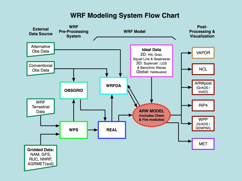
Modeling System Components
WRF Pre-processing System (WPS) Real-data interpolation for NWP runs New obsgrid program for adding more obs to analysis WRF Model (ARW and NMM dynamical cores) Initialization programs for real and (for ARW) idealized data (real.exe/ideal.exe) Numerical integration program (wrf.exe) Graphics and verification tools including MET WRFDA (separate tutorial) WRF-Chem (separate tutorial) WRF-Fire - fire-spread model for forest fires
 Real-data interpolation for NWP runs. New obsgrid program for adding more obs to analysis. WRF Model (ARW and NMM dynamical cores) Initialization programs for real and (for ARW) idealized data (real.exe/ideal.exe) Numerical integration program (wrf.exe) Graphics and verification tools including MET. WRFDA (separate tutorial) WRF-Chem (separate tutorial) WRF-Fire - fire-spread model for forest fires.")
11
WPS Functions Define simulation domain area (and nests)
Produce terrain, landuse, soil type etc. on the simulation domain (“static” fields) De-grib GRIB files for meteorological data (u, v, T, q, surface pressure, soil data, snow data, sea-surface temperature, etc.) Interpolate meteorological data to WRF model grid (horizontally) Optionally add more observations to analysis (separate obsgrid program)
 De-grib GRIB files for meteorological data (u, v, T, q, surface pressure, soil data, snow data, sea-surface temperature, etc.) Interpolate meteorological data to WRF model grid (horizontally) Optionally add more observations to analysis (separate obsgrid program)")
12
WPS Function (cont) Support WRF nesting Map projections:
ARW Lambert conformal, Polar stereographic, Mercator, rotated lat/long NMM Rotated lat/long Two grid-staggerings ARW C-grid NMM E-grid

13
WPS and WRF Running WPS Several executable stages with namelist input
geogrid.exe (interpolate maps and time-independent fields) ungrib.exe (convert time-dependent Grib-formatted data to simple binary format) metgrid.exe (interpolate time-dependent initial and boundary data) obsgrid.exe (optional stage to add more observations) Running WRF Two executable stages with namelist input real.exe or real_nmm.exe (set up vertical model levels for model input and boundary files) wrf.exe (run model)
 ungrib.exe (convert time-dependent Grib-formatted data to simple binary format) metgrid.exe (interpolate time-dependent initial and boundary data) obsgrid.exe (optional stage to add more observations) Running WRF. Two executable stages with namelist input. real.exe or real_nmm.exe (set up vertical model levels for model input and boundary files) wrf.exe (run model)")
14
WRFDA (Data Assimilation)
ARW only WRFDA (Data Assimilation) Variational data assimilation (3D-Var and 4D-Var) Ensemble DA Hybrid variational/ensemble DA Function Ingest observations to improve WRF input analysis from WPS May be used in cycling mode for updating WRF initial conditions after WRF run Also used for observation impact data studies
 Variational data assimilation (3D-Var and 4D-Var) Ensemble DA. Hybrid variational/ensemble DA. Function. Ingest observations to improve WRF input analysis from WPS. May be used in cycling mode for updating WRF initial conditions after WRF run. Also used for observation impact data studies.")
15
WRFDA Supported data types Background error covariance for ARW from
Conventional surface and upper air, wind profiler, aircraft Remote sensing data: Cloud-tracked winds, satellite-retrieved profiles, ground-based/satellite GPS, scatterometer ocean surface winds, radar radial velocity and reflectivity, satellite radiance Background error covariance for ARW from NMC method Ensemble method

16
WRF-Chem Supported by NOAA/ESRL
Includes chemistry species and processes, many chemistry options Also needs emissions data Included in WRF tar file, but requires special compilation option

17
WRF real and ideal functions
Creates initial and boundary condition files for real-data cases Does vertical interpolation to model levels (when using WPS) Does vertical dynamic (hydrostatic) balance Does soil vertical interpolations and land-use mask checks IDEAL (ARW only) Programs for setting up idealized case Simple physics and usually single sounding Initial conditions and dynamic balance
 Does vertical dynamic (hydrostatic) balance. Does soil vertical interpolations and land-use mask checks. IDEAL (ARW only) Programs for setting up idealized case. Simple physics and usually single sounding. Initial conditions and dynamic balance.")
18
WRF Model WRF Dynamical core (ARW or NMM) is compile-time selectable
Uses initial conditions from REAL or IDEAL Real-data cases use boundary conditions from REAL Runs the model simulation with run-time selected namelist switches (such as physics choices, timestep, length of simulation, etc.) Outputs history and restart files
 Outputs history and restart files.")
19
ARW Dynamics Key features:
Fully compressible, non-hydrostatic (with hydrostatic option) Mass-based terrain following coordinate, where is hydrostatic pressure, is column mass Arakawa C-grid staggering v u T u
 Mass-based terrain following coordinate, where is hydrostatic pressure, is column mass. Arakawa C-grid staggering. v. u T u.")
20
ARW Model Key features: 3rd-order Runge-Kutta time integration scheme
High-order advection scheme Scalar-conserving (positive definite option) Complete Coriolis, curvature and mapping terms Two-way and one-way nesting
 Complete Coriolis, curvature and mapping terms. Two-way and one-way nesting.")
21
ARW Model Key features:
Choices of lateral boundary conditions suitable for real-data and idealized simulations Specified, Periodic, Open, Symmetric, Nested Full physics options to represent atmospheric radiation, surface and boundary layer, and cloud and precipitation processes Grid-nudging and obs-nudging (FDDA) New Digital Filter Initialization option
 New Digital Filter Initialization option.")
22
NMM Dynamics Key features:
Fully compressible, non-hydrostatic or hydrostatic Mass-based sigma-pressure hybrid terrain following coordinate similar to ARW but with constant pressure surfaces above 400 hPa Arakawa E-grid staggering T V T V T V where V is u and v

23
NMM Dynamics

24
NMM Model Key features:
Adams-Bashforth and Crank-Nicholson time integration schemes High-order advection scheme Scalar and energy conserving Coriolis, curvature and mapping terms One-way and two-way nesting

25
NMM Model Key features:
Lateral boundary conditions suitable for real-data and nesting Full physics options to represent atmospheric radiation, surface and boundary layer, and cloud and precipitation processes

26
Graphics and Verification Tools
ARW and NMM RIP4 (Read, Interpolate and Plot) WRF Post-Processor (WPP) Conversion to GriB (for GrADS and GEMPAK) MET (Model Evaluation Toolkit) ARW NCAR Graphics Command Language (NCL) ARWPost Conversion program for GrADS and Vis5D
 WRF Post-Processor (WPP) Conversion to GriB (for GrADS and GEMPAK) MET (Model Evaluation Toolkit) ARW. NCAR Graphics Command Language (NCL) ARWPost. Conversion program for GrADS and Vis5D.")
29
Basic Software Requirement
Fortran 90/95 compiler C compiler Perl netCDF library Public domain mpich for MPI

30
Portability Runs on Unix single, OpenMP and MPI platforms:
IBM SP AIX (xlf) Linux (PGI, Intel, g95, gfortran, Pathscale compilers) SGI Altix (Intel) Cray XT (PGI, Pathscale) Mac Darwin (xlf, PGI, Intel, g95 compilers) Others (HP, Sun, SGI Origin, Compaq)
 Linux (PGI, Intel, g95, gfortran, Pathscale compilers) SGI Altix (Intel) Cray XT (PGI, Pathscale) Mac Darwin (xlf, PGI, Intel, g95 compilers) Others (HP, Sun, SGI Origin, Compaq)")
31
User Support User Web pages: ARW: NMM: Latest update for the modeling system WRF software download Various documentation Users’ Guide Technical Note (ARW Description)
")
32
ARW Hurricane Katrina Simulation (4km)
")
33
ARW Convective-scale Forecasting (4km)
")
34
Tutorial Schedule Lectures for WRF: Mon.-Fri.
Practice for WRF: Mon.-Fri. 2 Groups (a.m./p.m.) MET tutorial: Next Mon.-Tue.
 MET tutorial: Next Mon.-Tue.")
35
Tutorial Schedule Lectures for WRF: Wed.-Fri.
Practice for WRF: Wed.-Fri. 2 Groups (a.m./p.m.), 3 sessions WRFDA tutorial and practice: Sat.
, 3 sessions. WRFDA tutorial and practice: Sat.")
36
Data Flow wrfbdy ungrib wrf wrfinput metgrid geogrid real geo_em
intermediate times wrfbdy ungrib wrf GEOG_DATA wrfinput metgrid geogrid real times geo_em wrflowinp wrffdda met_em

Similar presentations


 Stacey Pensgen ESC 452 – Spring ’06.>")


 Alan Gadian, NCAS (Leeds) With thanks to Paul Connolly, Hector.>")

 pollutant Concentration change horizontal advection vertical advection horizontal dispersion vertical diffusion.>")

