Download presentation
Presentation is loading. Please wait.

1
MODULE 1 Groundwater management planning: Governance and Characterisation

2
Groundwater management planning Governance RBMPs - Structure, completeness, legal status Consultation of the public, engagement of stakeholders Characterisation of River Basin Districts – GD 26 Delineation of ground water bodies Identification of significant pressures and impacts Protected areas Monitoring – GD 15 Monitoring of groundwater Monitoring of protected areas Groundwater Status And Trend Assessment – GD 18 Temporal and Spatial Scale of Delineating RBs References and useful links

4
Key Elements of the European Water Framework Directive protecting all waters, surface and ground waters in a holistic way good quality (“good status”) to be achieved by 2015 integrated water management based on river basins combined approach of emission controls and water quality standards, plus phasing out of particularly hazardous substances economic instruments: economic analysis, and getting the prices right to promote prudent use of water getting citizens and stakeholders involved: public participation
 to be achieved by 2015 integrated water management based on river basins combined approach of emission controls and water quality standards, plus phasing out of particularly hazardous substances economic instruments: economic analysis, and getting the prices right to promote prudent use of water getting citizens and stakeholders involved: public participation")
5
Environmental objectives and exemptions Main environmental objectives in the directive are manifold and include the following elements (for details see Article 4 para. 1, (a) surface waters, (b) ground waters and (c) protected areas): No deterioration of status for surface and ground waters and the protection, enhancement, and restoration of all water bodies Achievement of good status by 2015, i.e. good ecological status (or potential) and good chemical status for surface waters and good chemical and good quantitative status for ground waters Progressive reduction of pollution of priority substances and phase- out of priority hazardous substances in surface waters and prevention and limitation of input of pollutants in ground waters Reversal of any significant, upward trend of pollutants in ground waters Achievement of standards and objectives set for protected areas in Community legislation
 surface waters, (b) ground waters and (c) protected areas): No deterioration of status for surface and ground waters and the protection, enhancement, and restoration of all water bodies Achievement of good status by 2015, i.e. good ecological status (or potential) and good chemical status for surface waters and good chemical and good quantitative status for ground waters Progressive reduction of pollution of priority substances and phase- out of priority hazardous substances in surface waters and prevention and limitation of input of pollutants in ground waters Reversal of any significant, upward trend of pollutants in ground waters Achievement of standards and objectives set for protected areas in Community legislation.")
6
6 “A process that promotes the coordinated development and management of water, land and related resources in order to maximize the resultant economic and social welfare in an equitable manner without compromising the sustainability of vital ecosystems.” Global Water Partnership GWMP Issues/opportunities Fact Sheets/Media Demos/Workshops Scientific Papers Concepts Products/Processes Demos/Workshops 1 2 3 4 5 6

7
GWMP “a process that promotes the coordinated development and management of water, land, and related resources in order to maximize the resultant economic and social welfare in an equitable manner without compromising the sustainability of vital ecosystems” (GWP TEC Paper 4, 2000) - Fresh water is a finite and vulnerable resource, essential to sustain life, development, and the environment. - Water development and management should be based on a participatory approach, involving users, planners, and policymakers at all levels. - Women play a central part in the provision, management and safeguarding of water. - Water has an economic value in all its competing uses and should be recognized as an economic good. - Essentially RBMP includes social, political, economic, and environmental aspects of managing water resources in an interdisciplinary manner. 7

12
Key elements to consider during future planning cycles

13
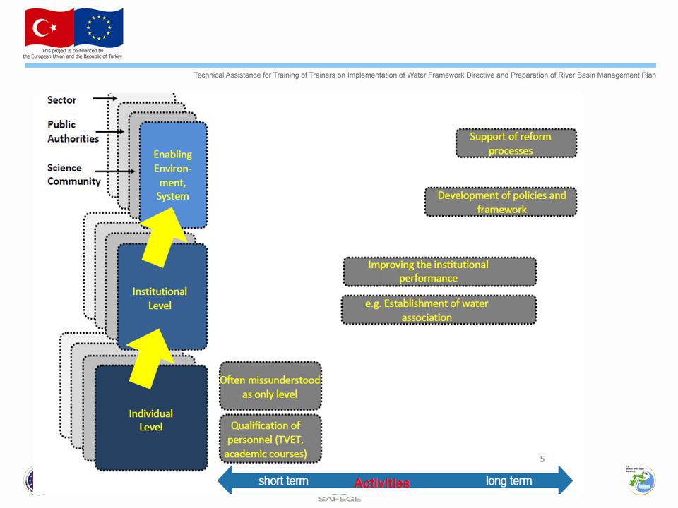
Groundwater governance: Interaction with different levels and sectors

14
Governance Scientific base development for policy making though strengthened groundwater quantity and quality monitoring, modeling and data sharing mechanism – supported by research communities and International organisations; Creation of enabling environment to ensure implementation and enforcement of laws and regulations in consideration of resources available, Promotion of water user involvement in planning, implementation and review of groundwater governance, especially at the lowest feasible level of implementation, which need proper incentives (not necessarily direct financial incentives) and rules of participation
 and rules of participation")
15
Governance Inclusion of water saving (demand management), conjunctive use and managed aquifer recharge (MAR) in the scope of groundwater governance to ensure sustainability of the resource; Facilitation of policy coordination with relevant sectors especially at national level, in particular with policies for surface water management, land-use planning, agriculture, and energy.
, conjunctive use and managed aquifer recharge (MAR) in the scope of groundwater governance to ensure sustainability of the resource; Facilitation of policy coordination with relevant sectors especially at national level, in particular with policies for surface water management, land-use planning, agriculture, and energy.")
16
Characterisation of River Basin Districts – GD 26 WFD Article 5 1. “…for each river basin district…: an analysis of its characteristic a review of the impact of human activity on the status of...groundwater … according to the Annex II…” 2. “… review/update 2013…and every 6 years thereafter.”

17
Annex II – Initial Characterisation all Groundwater Bodies … analysis … shall identify location and boundaries of GW-bodies pressures diffuse + point sources of pollution abstraction + artificial recharge general character of overlying strata directly dependent surface water- or terrestrial ecosystems Characterisation Requirements in the WFD Basis for Risk Assessment

18
Characterisation Requirements in the WFD Groundwater Bodies at risk – (Annex II, 2.2, 2.3) Transboundary Groundwater Bodies – (Annex II, 2.3) 2.2: …where relevant, information on e. g.: Geological characteristics, units….. Hydrogeological characteristics, conductivity, …. … 2.3: … where relevant Points for abstraction Abstraction rate, … Annex II – Further Characterisation

19
Conceptual Models Conceptual models are simplified representations, or working descriptions, of hydrogeological system being investigated

20
Main points during set-up of a conceptual model Main characteristics Scope and questions to be answered - to determine the degree of detail and complexity Determination of the relevant area. Definition of vertical and horizontal structuring units (hydrogeological units). Land use distribution Parameterisation/quantification Description and quantification of hydraulic, geochemical and hydrochemical parameters Consideration of processes with slow kinetics (solution processes, unsaturated zone flow, changes in surface conditions, climate variations) Description of the most important climatic and unsaturated zone parameters. Dealing with uncertainties assess potential uncertainties, variability, and where data are representative. Evaluation of a conceptual model start with a simple model, analyse its performance make a more complex model if the simpler model is not sufficient.
. Land use distribution Parameterisation/quantification Description and quantification of hydraulic, geochemical and hydrochemical parameters Consideration of processes with slow kinetics (solution processes, unsaturated zone flow, changes in surface conditions, climate variations) Description of the most important climatic and unsaturated zone parameters. Dealing with uncertainties assess potential uncertainties, variability, and where data are representative. Evaluation of a conceptual model start with a simple model, analyse its performance make a more complex model if the simpler model is not sufficient..")
21
Delineation of bodies of groundwater Ensure relevant objectives of the Directive can be achieved. Not required to be homogeneous in terms of: -natural characteristics, -concentrations of pollutants -level alterations within it. Enable appropriate description of quantitative and chemical status.

22
Identifying bodies of groundwater (GD 2) Identify Aquifers Provisionally identify body of groundwater on geological boundaries to flow Sub-divide using 1. Geological boundaries 2. Groundwater highs 3. Flowlines Confirm as body of groundwater Can the status of GW be accurately described at this scale? Iterative refinement using Annex II.2 characterisation and Article 8 monitoring Yes No

24
Meeting requirements of protected areas Chemical and Quantitative status, protected areas in practice via the requirement to assess risks to dependent ecosystems. Compliance with Article 7.3 (Drinking Water Protected Area objective) is one of the elements of meeting good groundwater chemical status. Risk assessment for drinking water abstraction sites all information within the catchment area on inputs, groundwater characteristics (geohydrology and -chemistry) analysed.
 is one of the elements of meeting good groundwater chemical status. Risk assessment for drinking water abstraction sites all information within the catchment area on inputs, groundwater characteristics (geohydrology and -chemistry) analysed..")
25
Monitoring Guidance for GW-GD 15 3 GENERAL PRINCIPLES 3.1 CONCEPTUAL MODELS AS BASIS FOR MONITORING 3.2 AQUIFER TYPES 3.3 GROUPING OF GROUNDWATER BODIES 3.4 INTEGRATED MONITORING 3.5 NETWORK REVIEW AND UPDATE 4 CHEMICAL STATUS AND TREND MONITORING 4.1 DESIGN OF THE SURVEILLANCE MONITORING PROGRAMME 4.1.1 Selection of surveillance monitoring determinands 4.1.2 Selection of representative surveillance monitoring sites 4.1.3 Monitoring frequency 4.2 DESIGN OF THE OPERATIONAL MONITORING PROGRAMME 4.2.1 Selection of operational monitoring determinands 4.2.2 Selection of representative operational monitoring sites 4.2.3 Monitoring frequency 5 QUANTITY MONITORING 5.1.1 Monitoring parameters 5.1.2 Selection of monitoring density 5.1.3 Monitoring frequency 6 PROTECTED AREA MONITORING 6.1 DRINKING WATER PROTECTED AREA MONITORING 7 PREVENT AND LIMIT MONITORING 8 ENSURING QUALITY OF MONITORING DATA 8.1 QUALITY REQUIREMENTS 8.2 QUALITY CONTROL 9 METHODS FOR SAMPLING AND ANALYSIS 10 REPORTING

26
Overview of monitoring objectives 1 ) Results will support characterisation in future RBMP cycles 2 ) Assumes new Groundwater Directive will require DWPA objectives to meet good status
 Results will support characterisation in future RBMP cycles 2 ) Assumes new Groundwater Directive will require DWPA objectives to meet good status")
27
Monitoring Programme Design Article 5 characterisation and risk assessment procedure and conceptual model/understanding of GW establish monitoring network representative for groundwater body focus on phenomena affecting overall state of groundwater body. Local scale pollution processes: target of different monitoring activities by authorities local impacts not relevant unless evolution in t and x endangers environmental objectives Consider three-dimensional nature of GW system, spatial and temporal variability, to determine location of monitoring sites and selection of appropriate site density existing quality and/or quantity data (length, frequency, range of parameters) construction characteristics of existing sites and abstraction regime spatial distribution of existing sites compared to the scale of groundwater body practical considerations relating to long-term access, security, health and safety. Appropriate monitoring site types: understanding of objectives of monitoring and understanding of travel times and/or groundwater ages Integrated monitoring: cost-efficient monitoring by using appropriate components of existing monitoring networks and operating integrated groundwater and surface networks
 construction characteristics of existing sites and abstraction regime spatial distribution of existing sites compared to the scale of groundwater body practical considerations relating to long-term access, security, health and safety. Appropriate monitoring site types: understanding of objectives of monitoring and understanding of travel times and/or groundwater ages Integrated monitoring: cost-efficient monitoring by using appropriate components of existing monitoring networks and operating integrated groundwater and surface networks.")
28
Conceptual models as basis for monitoring regional conceptual model – an understanding of the factors at groundwater body scale that identifies the need to establish a monitoring network/point and how the data will be used; local conceptual model – an understanding of the local factors influencing the behaviour, both in chemical and quantitative terms, of individual monitoring points.

29
Conceptual Model-Basis for Monitoring

30
MODULE 1 Groundwater management planning: Status and Trend Assessment

31
Background Current activity of WG C Groundwater – Subgroup « Status compliance and Trends » Mandate: TV Article 3 of the GWD (« criteria for assessing groundwater chemical status ») Based on BRIDGE outcomes Environmental objectives of the GWD / Receptors to protect Articles 3 and 4 (status assessment) Surface water Groundwater Dependant Terrestrial Ecosystems (GWDTE) Human uses Article 5 (trends) Groundwater « itself » (Surface water, GWDTE, Human uses) Article 6 (prevent or limit) Groundwater « itself » (Surface water, GWDTE, Human uses) Full protection of groundwater Groundwater Status And Trend Assessment – GD 18
 Based on BRIDGE outcomes Environmental objectives of the GWD / Receptors to protect Articles 3 and 4 (status assessment) Surface water Groundwater Dependant Terrestrial Ecosystems (GWDTE) Human uses Article 5 (trends) Groundwater « itself » (Surface water, GWDTE, Human uses) Article 6 (prevent or limit) Groundwater « itself » (Surface water, GWDTE, Human uses) Full protection of groundwater Groundwater Status And Trend Assessment – GD 18")
32
Legal background: GWD (2006/118/EC) Main objectives and requirements –Groundwater Quality Standards (GW-QS) –Threshold values (TV) for: Parameters causing a risk of failing 2015 objectives Including NO 3 and/or pesticides if relevant Taking the minimum list into account The links between Article 3 and Article 6 Article 3Article 6 Large scale (Groundwater Body - GWB)Local scale (groundwater) Apply to the whole GWB (‘threshold values’) Apply to different ‘Point Of Compliance’(POC) (‘limit values’) Criteria: Surface water, GWDTE, human uses, saline or other intrusions Criteria: Surface water, GWDTE, human uses (including future uses), saline or other intrusions, material property, amenities Source: A. Blum; WG C meeting Berlin 07

33
Background Required scale for deriving TV 3 possible levels (article 3.2) National, River district, GWB Consequence: GWB = the smallest allowed scale for the TV to be reported in the management plan GWB heterogeneity will have to be taken into account through intermediate values ( « criteria’s values ») and through the appropriate investigation Schedule and revision Key dates (Article 3.5) TV to be established by 22 December 2008 TV to be published in the RBMP by 22 December 2009 Revision (Article 3.6) Information to be reported in the RBMP Transboundary GWB Source: A. Blum; WG C meeting Berlin 07

34
Identification of receptors GW associated surface waters Rivers, Lakes Transitional, Coastal waters GW-dependent terrestrial ecosystems and wetlands / mire / GW-fed fens Human uses (drinking water, irrigation, industrial use, farming, …)
")
36
Background Level Derive background levels for all groundwater bodies (shallow and deep groundwater) According to the GWD (Article 2.5), “background level” means concentration of a substance or value of an indicator in a body of groundwater corresponding to no, or only very minor, anthropogenic alterations to undisturbed conditions”. Because background levels can, for some parameters and some type of groundwater body, be very high, it is of major importance to identify these background levels as a first step in the status and trend assessments.

37
Methodology to derive TV Preliminary steps What are the relevant criteria for the status assessment? - Extent of interactions between groundwater and associated aquatic and dependent terrestrial ecosystems - Interference with actual or potential legitimate uses What are the parameters for qualifying a water body’s chemical status? All pollutants that characterise groundwater bodies as being at risk of not meeting WFD environmental objectives Assessing hydrogeological characteristics including information on natural background level of each of the relevant parameters Source: A. Blum; WG C meeting Berlin 07

39
Others… Select the relevant criteria Environmental criteria Usage criteria Selection of legitimate uses which surface is significant compared to the whole surface of the GWB GWDTE Drinking water Industry Crops Identify most stringent TV Derive a Criteria Value (CV) for each of the relevant receptors CV 3 Compare CVi to background level (BL) CV 2 = EQS*AF 2 /DF Methodology to derive TV Two Criteria to be considered Aim to protect Surface waters Saline Intrusion CV 1 = BL CV 4 = DWS CV İ… CV 6 CV 5 If CVi ≤ BL then TVi = BL If CVi > BL then BL < TVi ≤ CVi TV 3 TV 2 TV 1 TV 4 TV 6 TV 5 EQS = Environmental Quality Standard AF= Attenuation Factor, DF=Dilution Factor AF and DF to be defined by Member State. In case data is not sufficient, AF=DF=1 define TV according to national strategies and risk assessment

40
Assess a GWB chemical status

41
Reporting Information to provideScale for reporting General information Number of GWB at risk National List of parameters indicative of and relevant to the associated risk Range of concentrations for each parameter Information for each groundwater body at risk Size Body or group of bodies of groundwater Relationships with surface waters and GWDTE Threshold values for each parameter responsible for a risk NBL (in the case of naturally occurred parameter) Environmental quality objectives and other standards Information on toxicology, eco-toxicology, persistence, bioaccumulation, dispersion of the pollutant * Usage criteria are relevant use based standards, such as drinking water standards, irrigation standards etc. If the monitoring point where compliance against the TV is to be assessed is not the abstraction point, it may be appropriate to take into account dilution and attenuation when deriving the TV.

42
General assessment of chemical status of GWB as a whole * A weighting approach can help taking regard of conceptual model (e.g. pressure, vulnerability, impact situation) within the groundwater body as well as of the monitoring network design. ** Proceed according to Article 4(5) GWD
 within the groundwater body as well as of the monitoring network design. ** Proceed according to Article 4(5) GWD.")
43
Definition of Good Quantitative Status available groundwater resource is not exceeded by long term annual average rate of abstraction Anthropogenic water level alterations no significant diminution of surface water chemistry and/or ecology that would lead to failure of relevant Article 4 objectives for any associated surface water bodies no significant damage to groundwater dependent terrestrial ecosystems no saline or other intrusions.

44
Reading Materials-Technical Reports CIS Working Group on groundwater worked out the following Technical Reports (TR): Groundwater Trends (TR No 1) Groundwater Characterization (TR No 2) Groundwater Monitoring (TR No 3) Groundwater Risk Assessment (TR No 4) Groundwater Management in the Mediterranean (TR No 5) Groundwater Dependent Terrestrial Ecosystems (TR No 6) Recommendations for the Review of Annexes I- II of the Groundwater Directive 2006/118/EC (TR No 7)
: Groundwater Trends (TR No 1) Groundwater Characterization (TR No 2) Groundwater Monitoring (TR No 3) Groundwater Risk Assessment (TR No 4) Groundwater Management in the Mediterranean (TR No 5) Groundwater Dependent Terrestrial Ecosystems (TR No 6) Recommendations for the Review of Annexes I- II of the Groundwater Directive 2006/118/EC (TR No 7)")
45
GENESIS In 2009, the EU funded a 5 year project named GENESIS (VII Framework Programme). Coordinated by the Norwegian Institute for Agricultural and Environmental Research (Bioforsk), involved 25 partners from 17 countries. Integrate pre-existing and new scientific knowledge into the development of methods, concepts, and tools for better management of groundwater resources. Provide suggestions for the revision of the Groundwater Directive. Impacts of land use and climate change have been integrated with the conceptual model so groundwater systems emphasizing on the role of Groundwater Dependent Ecosystems(GDEs).
, involved 25 partners from 17 countries. Integrate pre-existing and new scientific knowledge into the development of methods, concepts, and tools for better management of groundwater resources. Provide suggestions for the revision of the Groundwater Directive. Impacts of land use and climate change have been integrated with the conceptual model so groundwater systems emphasizing on the role of Groundwater Dependent Ecosystems(GDEs)..")
46
Supporting research BRIDGE project (“Background cRiteria for the IDentification of Groundwater thrEsholds”), designed to develop a common methodology WG on Groundwater under CIS of WFD is collaborating with International Hydrological Programme (IHP) of UNESCO International Association of Hydrogeologists (IAH), Eurogeosurveys, the European Water Association (EWA), the International Groundwater Resources Assessment Centre (IGRAC)
, designed to develop a common methodology WG on Groundwater under CIS of WFD is collaborating with International Hydrological Programme (IHP) of UNESCO International Association of Hydrogeologists (IAH), Eurogeosurveys, the European Water Association (EWA), the International Groundwater Resources Assessment Centre (IGRAC)")
47
BRIDGE project

50
Work-package 1: Survey of representative groundwater pollutants Project launching and co-ordination Work-package 2: Study of groundwater characteristics Work-package 3: Criteria for environmental thresholds and methodology to define a good status Work-package 4: Representative sites / water body studies and compliance testing Work-package 5: Economic and social costs linked to the establishment of groundwater threshold values Work-package 6: Information and dissemination

51
FOCUS groundwater scenarios http://focus.jrc.ec.europa.eu/gw/index_with_doc.html Set of nine standard combinations of weather, soil and cropping data which collectively represent agriculture in the EU for the purposes of a Tier 1 EU-level assessment of leaching potential.

Similar presentations


 Ramsar Convention on Wetlands (www.ramsar.org) Convention on Wetlands “The conservation and wise use of.>")


 Regulations 2010 S.I. 9. of 2010 Colin Byrne Water Inspector.>")


![Kavala Workshop 1-2 June 2006 Legal protection of Transitional Waters [in the Cadses area]: A comparative analysis Dr. Petros Patronos / Dr. Liliana Maslarova.](/25/7901785/big_thumb.jpg "Kavala Workshop 1-2 June 2006 Legal protection of Transitional Waters [in the Cadses area]: A comparative analysis Dr. Petros Patronos / Dr. Liliana Maslarova.>")
 Peter Webster Regional Chemist (EPA Cork)>")


