Download presentation
Presentation is loading. Please wait.

1
Spills/Incident Management Monitoring, Mapping and Contingency Planning Jerry Schulte, Manager Source Water Protection and Emergency Response for ORSANCO and UMBRA Joint Meeting Technical/Water Quality Session June 5, 2013

2
Ohio River 32 Public Drinking Water Supplies >5 million people

3
ORSANCO Source Water Protection Program Integration WATER QUALITY MONITORING INTER-AGENCY COMMUNICATION EMERGENCY RESPONSE OSWPOSWP

4
ORSANCO Monitoring Programs Metals (Dissolved/Total Recoverable) Nutrients (Nutrient Criteria Development) Bacteria (TMDL) Algae (Recreation and Drinking Water Protection) Biota (fish, bugs, mussels, fish tissue) Pesticides (Atrazine) Volatile Organics (Organics Detection System)
 Nutrients (Nutrient Criteria Development) Bacteria (TMDL) Algae (Recreation and Drinking Water Protection) Biota (fish, bugs, mussels, fish tissue) Pesticides (Atrazine) Volatile Organics (Organics Detection System)")
5
Tremendous Inter-agency communication due to committee structure 6 mainstem state environmental quality agencies – State EPAs, health, emergency response, fish management, etc. 3 USEPA regions USFWS, USGS, USACE, USCG ORSANCO Communication Programs

6
ORSANCO Emergency Response Programs Spill communication system – Supported by ORSANCO staff Receive NRC Spill Reports for all counties along Ohio River and major tributaries 24/7 Communicate necessary ones to utilities Support utilities needs during spill events Time of travel calculations Estimates of in-stream concentrations Sample collection and analysis

7
ORSANCO Source Water Protection Program Integration WATER QUALITY MONITORING INTER-AGENCY COMMUNICATION EMERGENCY RESPONSE OSWPOSWP

8
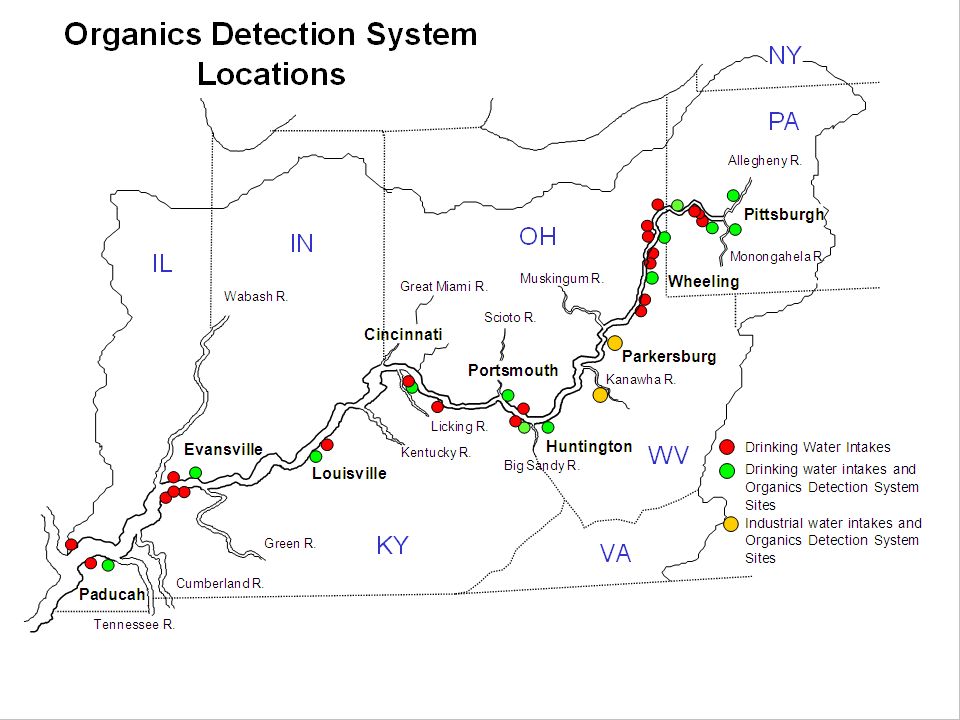
Organics Detection System Established 1978 after Carbon Tetrachloride released into the Kanawha River contaminated water supply systems in Huntington, Portsmouth, Cincinnati. Initial assistance from utilities, ORSANCO and U.S.EPA to establish seven monitoring stations. By 1985 13 ODS stations were operational Presently 16 stations spanning over 1000 miles of navigable waters from Pittsburgh to Paducah

10
ODS Analytical Equipment GC/Mass Spec

11
ODS Analytical Equipment INFICON CMS 500 Gas Chromatograph with argon ionization detector and continuous flow purge cell

12
ODS Analytical Equipment

13
ODS - System Operation Collect and analyze four samples of untreated river water every 24 hours (blank, ccv, raw) Detections exceeding 2ug/L prompt ORSANCO notification by operator The detection is verified by operator and ORSANCO ODS staff Notifications to drinking water utilities, NRC and state emergency response agencies
 Detections exceeding 2ug/L prompt ORSANCO notification by operator The detection is verified by operator and ORSANCO ODS staff Notifications to drinking water utilities, NRC and state emergency response agencies")
14
Compounds Identified by the ODS StyreneBromodichloromethane BromoformCarbon Tetrachloride ChloroformDibromochloromethane 1,1 Dichloroethane1,2 Dichloroethane 1,1 Dichloroethylene1,2 Dichloropropane Methylene ChlorideTetrachloroethylene 1,1,1 TrichloroethaneTrichloroethylene TrichlorofluoromethaneBenzene ChlorobenzeneEthylbenzene 1,2 Dichlorobenzene1,3 Dichlorobenzene 1,4 DichlorobenzeneToluene

15
THO 160 ug/l, MCL FOR TOLUENE 1,000 ug/l ODS Spill Detection Organics Detection System – Why?

16
THO 1000 ug/l, MCL FOR PERC 5 ug/l

19
TABLE OF CONTENTS PROCEDURES 1 SPILL NOTIFICATION 3 STATE AGENCIES FEDERAL AGENCIES NATIONAL RESPONSE CENTER 5 U.S. EPA 5 U.S. COAST GUARD 6 U.S. ARMY CORPS OF ENGINEERS EMERGENCY RESPONSE COORDINATORS WORKGROUP 8 ODS QUICK REFERENCE 10 OHIO RIVER DRINKING WATER INTAKE CONTACT INFORMATION 11 TRIBUTARY DRINKING WATER INTAKE CONTACT INFORMATION 17 RIVER MILE POINTS OF COUNTIES BORDERING THE OHIO RIVER 22 OHIO RIVER MAIN STEM NAVIGATION SYSTEM 18 OHIO RIVER LOCKS AND DAMS 19 ALLEGHENY, MONONGAHELA, AND KANAWHA RIVER LOCKS AND DAM 21 TRIBUTARIES TO THE OHIO RIVER 23 INDUSTRIAL FACILITIES 29 SOURCES OF CHEMICAL AND ENVIRONMENTAL DATA 30 RIVER HYDROLOGIC INFORMATION 30 RIVER STAGE INFORMATION 30 CHEMTREC 30 CONVERSION FACTORS 31 OHIO RIVER MILE POINTS 32 OHIO RIVER COUNTIES, DRINKING WATER INTAKES AND LOCKS & DAMS (0.0-490.0) OHIO RIVER COUNTIES, DRINKING WATER INTAKES AND LOCKS & DAMS (460.0- 981.3) Emergency Response Directory
 OHIO RIVER COUNTIES, DRINKING WATER INTAKES AND LOCKS & DAMS ( ) Emergency Response Directory.")
20
Spill Coordination Workgroups Upper Ohio River Focus Group – Emergency Response, water quality, SID, CID Federal, state Cincinnati Sub-area Focus Group – Incident Action Plan and Tactical Response Plan Federal, state, local, industries Great Rivers Spills Communication Group – Ohio, Mississippi and Tennessee Rivers Federal, state Huntington Area Tri-State Spills Communication Group Federal, state, local, industries

Similar presentations


 Federal Advisory Board DHS Challenges & Opportunities Captain Curtis Dubay, P.E. Department.>")
 Notification SOP.>")


 Training.>")


