Download presentation
Presentation is loading. Please wait.

1
Data Way Forward + INSPIRE contribution Max Craglia European Commission Joint Research Centre based on presentation by George Percivall, Open Geospatial Consortium made at ADC-12 Melbourne Australia 15 September 2009

2
Data Way-Forward Discussion group Ad-hoc discussion group formed by an action from ADC Co-chairs telecon Main emphasis: –Increasing availability of data through GCI and the broader GEOSS –Considering access and value-adding to data in open distributed environment –Influence ADC Data Tasks and AIP-3 Discussion group include: Ken McDonald, Jay Pearlman, Siri Jodha Singh Khalsa, Rob Koopman, Alessandro Annoni, and George Percivall (editor)
")
4
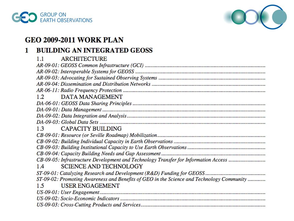
Data Way Forward Topics Global datasets Services for access to data and information Implications of data sharing principles Data quality Information architecture

5
Several global datasets are underway – are more needed? Task DA-09-03 includes several categories of global datasets: Land Cover; Meteorological and Environmental; Geological; and DEM Most of these are geophysical. Also need health, population, sociological, species distribution Considering the base data categories identified in other activities (INSPIRE, FGDC, GCOS, others) should ADC identify and promote additional global datasets in DA-09-03? Link to Summit planning (Document 21)
 should ADC identify and promote additional global datasets in DA Link to Summit planning (Document 21).")
6
Continue to increase Access Services GEOSS 10 Year Plan envisions access to data and information through service interfaces –Move from Order and delivery of files to Access Services Most global dataset tasksheets say nothing about making data available through services. –An exception is DA-09-03c - OneGeology AIP-3 increase data access services and ensure services are correctly registered in the GEOSS CSR. –Discovery of ASTER GDEM via the GCI should become a case study in how the GCI is failing –WIS is registered but you need to go to WIS to find services

7
Consider implications of data sharing principles Continue to participate in review of DSTF Guidelines and Action Plan –policy and requirements on GEOSS interoperability arrangements for access services Consider existing practices, e.g., Landsat and ASTER require user registration with the data center Topics considering multiple provider environment. –authentication of user identity for data with restricted access, –Notification and acknowledgment of copyright restrictions, licenses –mechanisms for assurance that data is uncorrupted. –charges and fees, when appropriate. Link to DA-09-02A Data Integration and analysis systems AIP-3 –Consider methods for licenses and user registration –Technologies like single-sign-on could be investigated

8
Quality Assurance is vitally important in a distributed information system. Task DA-09-01a - quality assurance of EO data. QA4EO information propagated into information systemsQA4EO Consider international standards for quality of geographic information, e.g., ISO TC211 standards, is needed. Interoperability arrangements for the propagation of uncertainty in a distributed information system is required, –e.g., Uncertainty Markup Language (UnCertML ).UnCertML Validation of datasets with user feedback from larger audience to allow that information to get back to the data provider.
.UnCertML Validation of datasets with user feedback from larger audience to allow that information to get back to the data provider..")
9
Data Fusion/Integration is only possible with a harmonized information architecture. GEOSS 10 Year Plan RD anticipates GEOSS will enable new value-added products resulting from fusion/integration of diverse Earth Observation and socio-economic data. Harmonized information architecture allows sharing across different disciplines. DA-09-01b (data harmonization task) and AIP-3 can be a starting point for such information architecture. Multiple topics in an information architecture that must accommodate dataset lifecycle
 and AIP-3 can be a starting point for such information architecture. Multiple topics in an information architecture that must accommodate dataset lifecycle.")
10
European contribution to GEOSS from INSPIRE: Global datasets + Information architecture Contribution through interoperable/ harmonized European data sets on 34 INSPIRE themes Annex I –Coordinate reference systems –Geographical grid systems –Geographical names –Administrative units –Addresses –Cadastral parcels –Transport networks –Hydrography –Protected sites Annex II –Elevation –Land cover –Ortho-imagery –Geology Annex III –Statistical units –Buildings –Soil –Land use –Human health and safety –Utility and governmental services –Environmental monitoring facilities –Production and industrial facilities –Agricultural and aquaculture facilities –Population distribution – demography –Area management/restriction /regulation zones & reporting units –Natural risk zones –Atmospheric conditions –Meteorological geographical features –Oceanographic geographical features –Sea regions –Bio-geographical regions –Habitats and biotopes –Species distribution –Energy Resources –Mineral resources

11
Data harmonisation components coordinate reference systems (CRS); geospatial information types (features, coverages, observations and metadata), application schemas, product definition process, multilingualism and ontologies
; geospatial information types (features, coverages, observations and metadata), application schemas, product definition process, multilingualism and ontologies")
12
Services for access to data and information Discovery and View services –Key building block of any SDI. Important to make an assessment of resources available. –supporting both European and international Coordinate Reference Systems. Download and Transformation Services –providing access to harmonised data either directly or via services able to transform the data models from the national ones to INSPIRE ones. –Interoperability through services in practice. Important input to GEOSS.

13
INSPIRE Geoportal: testing solutions in a multilingual context - GEOSS relevant Current focus on –INSPIRE Discovery & View services, metadata –Tools (metadata editor, multilinguality, …) Technical aspects addressed: –Access to distributed INSPIRE Network Services –Performance, Quality of service –Multilingual support (GEMET, translators, …) Discovery & view web clients based on open source S/W and internal development –Support the draft Technical guidelines (OGC CSW ISO AP, ISO 19128) Based on the prototype geoportal, specifications for the operational portal will be drafted. Public procurement expected end- 2011 Operational infrastructure subject to the availability and testing of Member States INSPIRE network services http://www.inspire-geoportal.eu

14
Supporting GEOSS data sharing principles Metadata critical to support data sharing principles and implementation guidelines –To express who is responsible for the data/service (who to contact for further info + attribution) –Where to find the data/service + how to access –If there are restrictions of any sort –If there are charges of any sort –What quality can be expected / conformance with international specifications INSPIRE Metadata Regulation requires all EU countries to create and maintain MD fulfilling these requirements
 –Where to find the data/service + how to access –If there are restrictions of any sort –If there are charges of any sort –What quality can be expected / conformance with international specifications INSPIRE Metadata Regulation requires all EU countries to create and maintain MD fulfilling these requirements")
15
INSPIRE MD for Datasets and Services Resource title Resource abstract Resource type Resource locator Unique resource identifier Coupled resource Spatial data service type Resource language Topic category Keyword Geographic bounding box Temporal reference Lineage Spatial resolution Conformity Conditions for access and use Limitations on public access Responsible organisation Metadata point of contact Metadata date Metadata language Only data Only services Both data and services

16
MD Editor http://www.inspire-geoportal.eu / Allows to create MD compliant with INSPIRE and ISO 19115/19119 Allows to export to XML But not downloadable or multilingual EUROGEOSS project will deliver Open Source version downloadable and in 23 languages for the INSPIRE elements + easily extendable to other thematic communities

17
Thank you massimo.craglia@jrc.ec.europa.eu For more information on INSPIRE http://inspire.jrc.ec.europa.eu/ For more information on EUROGEOSS www.eurogeoss.eu

Similar presentations


 Data scope in INSPIRE European Commission Joint Research Centre Institute for Environment and Sustainability Digital Earth and Reference Data Unit.>")


 INSPIRE principles, components and implementation>")

