Download presentation
Presentation is loading. Please wait.

1
http://institute.nsta.org/web_seminars.asp JPL/NSTA Web Seminar: Inquire, Engage and Explore: The Mars Student Imaging Project LIVE INTERACTIVE LEARNING @ YOUR DESKTOP

2
Inquire, Engage and Explore: The Mars Student Imaging Project

3
MARS ODYSSEY October 24, 2001

4
Thermal Emission Imaging System (THEMIS) Visible Imaging System –Visible-light images with 18 meters per pixel resolution. –MSIP Students use this imaging system Infrared Imaging System –The entire planet will be mapped in the infrared at 100 meters per pixel resolution.

5
MSIP Overview Students: Learn about and model the process of science Contribute to what is known about Mars by conducting their own research Can possibly command a NASA satellite Incorporate science, math, reading, and writing in a real-world application

6
Question If you had the opportunity to have your students use a NASA orbiter and camera to take their own team image of Mars as part of a research project, would you be interested in participating? Yes No Not sure

7
MSIP Resources Curriculum manuals are available at http://msip.asu.edu MSIP Staff helps mentor teachers through the process For questions, email: msip@asu.edu

8
MSIP Distance Learning Conferences FREE monthly conferences provide access to experts. Conferences offered twice in a day in order to accommodate different time zones.

9
3 Formats of Participation 1. On-Site 2. Distance Learning 3. Archived To Get Started: –Submit an application

10
Which format do you think allows students to: Conduct authentic Mars research Participate in nationwide distance learning conferences Potentially publish their results on the MSIP website Question On-site Distance- Learning Archived

11
On-Site Format Students have the opportunity to: Conduct part of their research at the Mars Space Flight Facility on the campus of Arizona State University, Tempe, AZ Work with scientists and Mars Education staff Acquire their team targeted THEMIS image of Mars Compile their data and present their research to the staff at the Mars Space Flight Facility Participate in nationwide conferences

12
Distance Learning Format Students have the opportunity to: Conduct their research without every leaving their school site Work with scientists and Mars Education staff at the Mars Space Flight Facility via internet, video or teleconferences Participate in nationwide conferences Acquire their team targeted THEMIS image of Mars Present their research to staff at the Mars Space Flight Facility

13
Archived Format Students have the opportunity to: Conduct their research without every leaving their school site Use archived data for their research Participate in nationwide conferences Have their findings posted on the MSIP Team Results webpage

15
Mars Student Imaging Project Teams Diverse groups of students

16
On-Site and Distance- Learning teams can create their own MSIP Team poster of “their” piece of Mars.

17
Activity Goals: Familiarize you, using a “hands-on” approach, with what you can see in THEMIS visible images Make observations of THEMIS visible images Make estimated measurements of features to incorporate mathematics MARS IMAGE ANALYSIS ACTIVITY

18
Mars Image Analysis Materials Latitude and longitude shown under context image 1. MOLA map of Mars 2. Laminated THEMIS visible image AND context image 3. Feature ID Charts (5 charts) 4. Erasable markers
 4. Erasable markers.")
19
4 Steps of the Activity: 1.Using the latitude and longitude provided on the image, find the location of your image on the MOLA map. 2.Using the Feature ID Charts, label geologic features in both your context and THEMIS image. 3.Think about the “history of your area” – What’s older, what’s younger? What’s happened here?!? 4.Make estimated (or actual) measurements on THEMIS visible image. Mars Image Analysis
 measurements on THEMIS visible image. Mars Image Analysis.")
20
MOLA Map 180° 210° 240° 270° 300° 330° 0° 30° 60° 90° 120° 150° 180° East Longitudes 60° 30° 0° -30° -60°

21
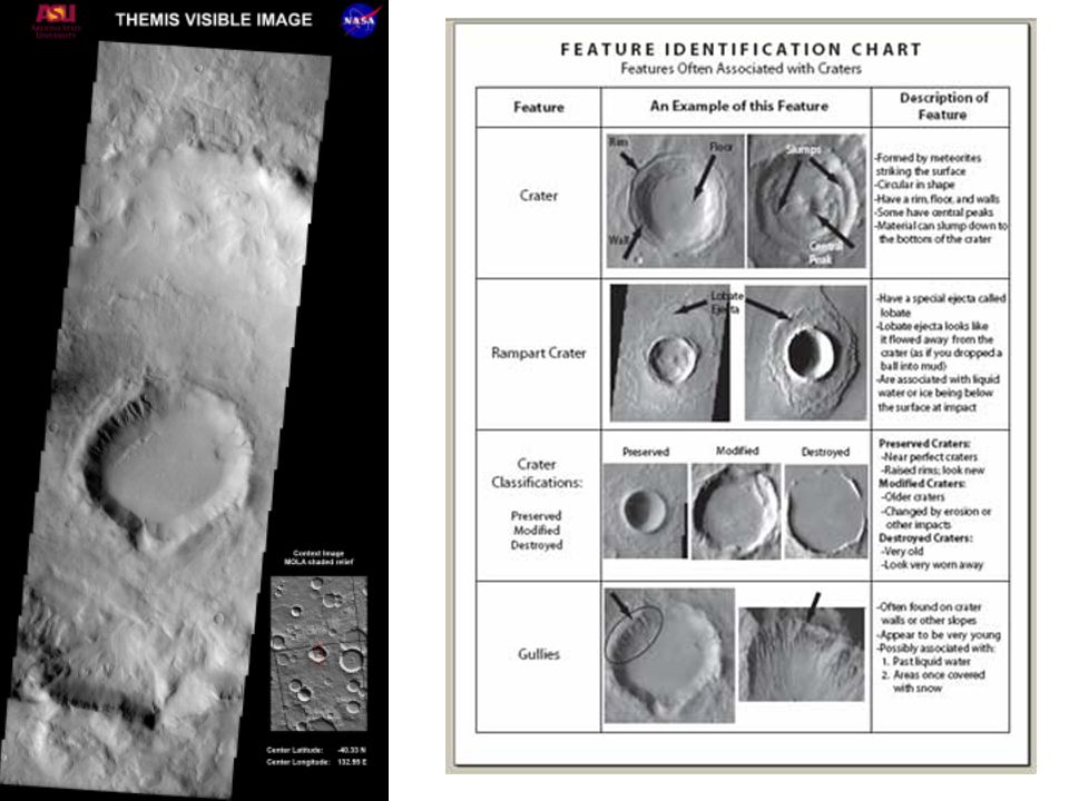
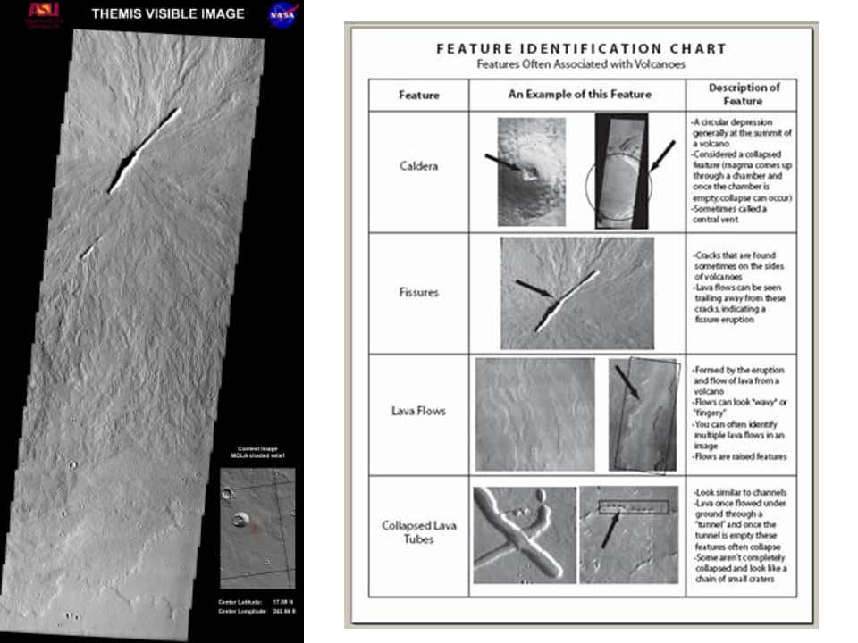
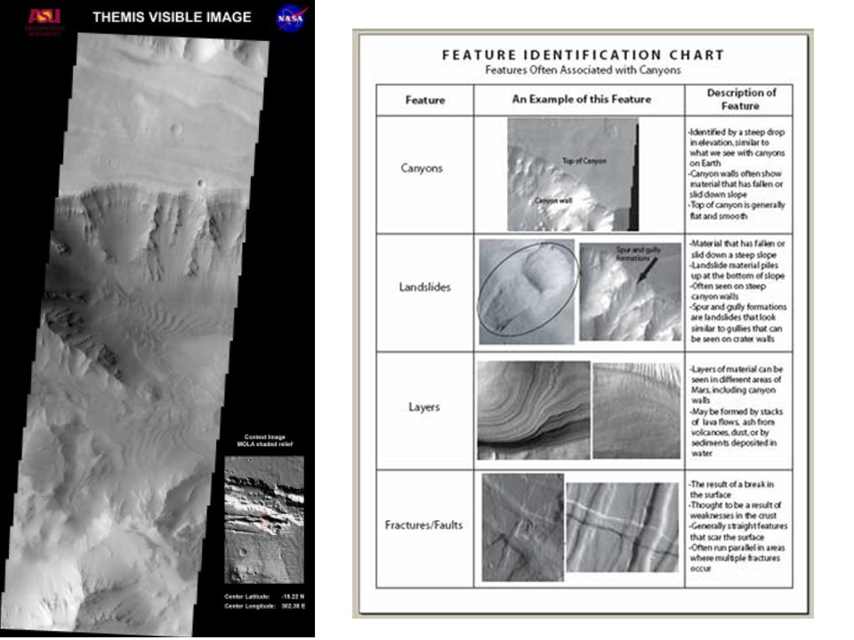
THEMIS Visible Image Context Image: MOLA Shaded Relief -19N, 173E THEMIS images are taken during the afternoon and the sun is shining from the left THEMIS visible images are ~18 km across CONTEXT images appear to have the sun shining from the right

22
Feature ID Charts Categorized by topic: Craters Channels Volcanoes Water-Related Wind-Related

23
What we will do: 1.Using the Feature ID Chart(s), label geologic features in both your context and THEMIS images. 2.Make estimated measurements on THEMIS images only. Mars Image Analysis

29
Closing MSIP Remarks MSIP gives students a chance to conduct authentic research, model the science process, and contribute to what is known about Mars The MSIP Staff will work with you to help you make a plan to fit your classroom needs DON’T MISS OUT on the opportunity to have your students use the Mars Odyssey spacecraft and ASU’s THEMIS visible camera!!!

30
Useful Links Available at NSTA Website: http://institute.nsta.org/JPL/webseminar2.asp MSIP Website THEMIS Website Video clip of how to do the Mars Image Analysis Activity MSIP Application Lendable Mars Image Analysis Image sets: Submit an MSIP application and email msip@asu.edu

31
National Science Teachers Association Gerry Wheeler, Executive Director Frank Owens, Associate Executive Director Conferences and Programs Al Byers, Assistant Executive Director e-Learning LIVE INTERACTIVE LEARNING @ YOUR DESKTOP NSTA Web Seminars Flavio Mendez, Program Manager Jeff Layman, Technical Coordinator Judith Lopes, Administrative Assistant Susan Hurstcalderone, Volunteer Chat Moderator

Similar presentations


 Visible Imaging System –Visible-light images with 18 meters per pixel resolution.>")


