Download presentation
Presentation is loading. Please wait.

1
U.S. Department of the Interior U.S. Geological Survey 2006 Indiana GIS Conference March 8, 2006 - Indianapolis Charles Hickman USGS National Geospatial Program Office

2
Disciplines of the U.S. Geological Survey Geology (GD) Water Resources (WRD) Biological Resources (BRD) Geography and Mapping (National Geospatial Program Office)
 Water Resources (WRD) Biological Resources (BRD) Geography and Mapping (National Geospatial Program Office).")
3
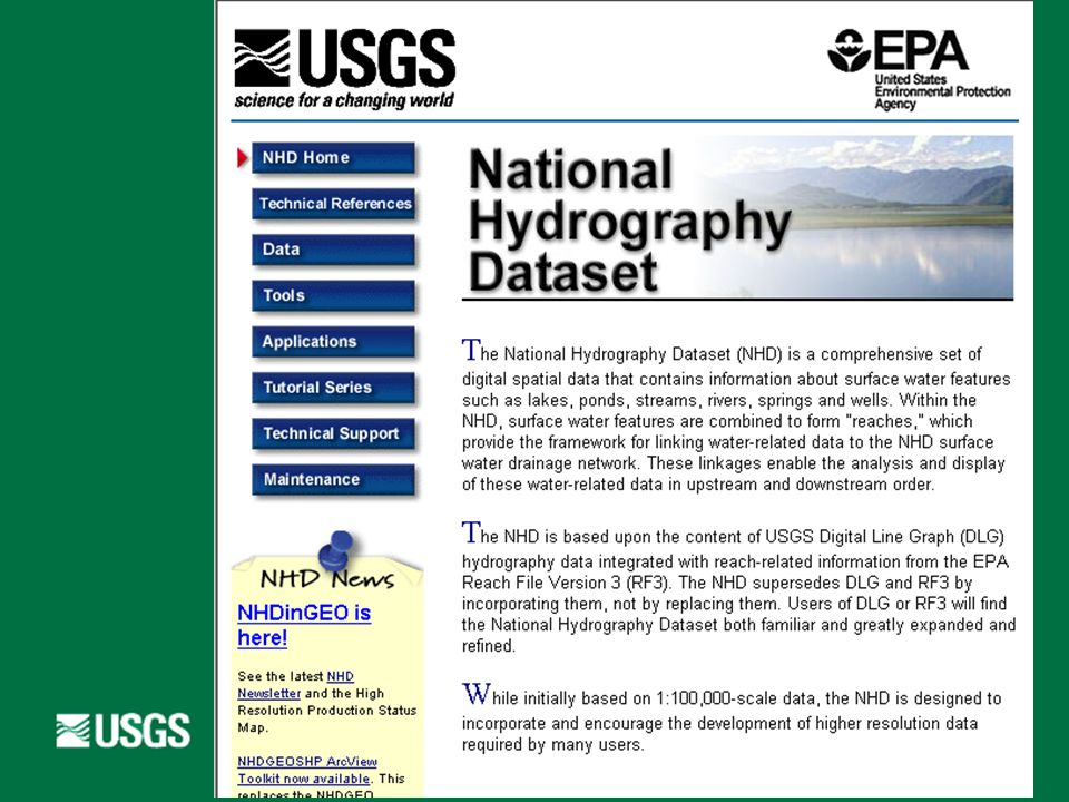
National Hydrography Dataset A comprehensive set of digital spatial data that contains information about: naturally occurring and constructed bodies of water natural and artificial paths through which water flows related hydrographic entities.

4
National Hydrography Dataset Stream network – streams, canals, other paths: 80% Water bodies – lakes, reservoirs, other areas: 14% Landmarks – dams, bridges, geysers, other items: 6%

5
National Hydrography Dataset National program Combine hydro spatial data programs of USGS DLG EPA RF3 USFS CFF other national, state, and regional partners Coordinate update efforts

6
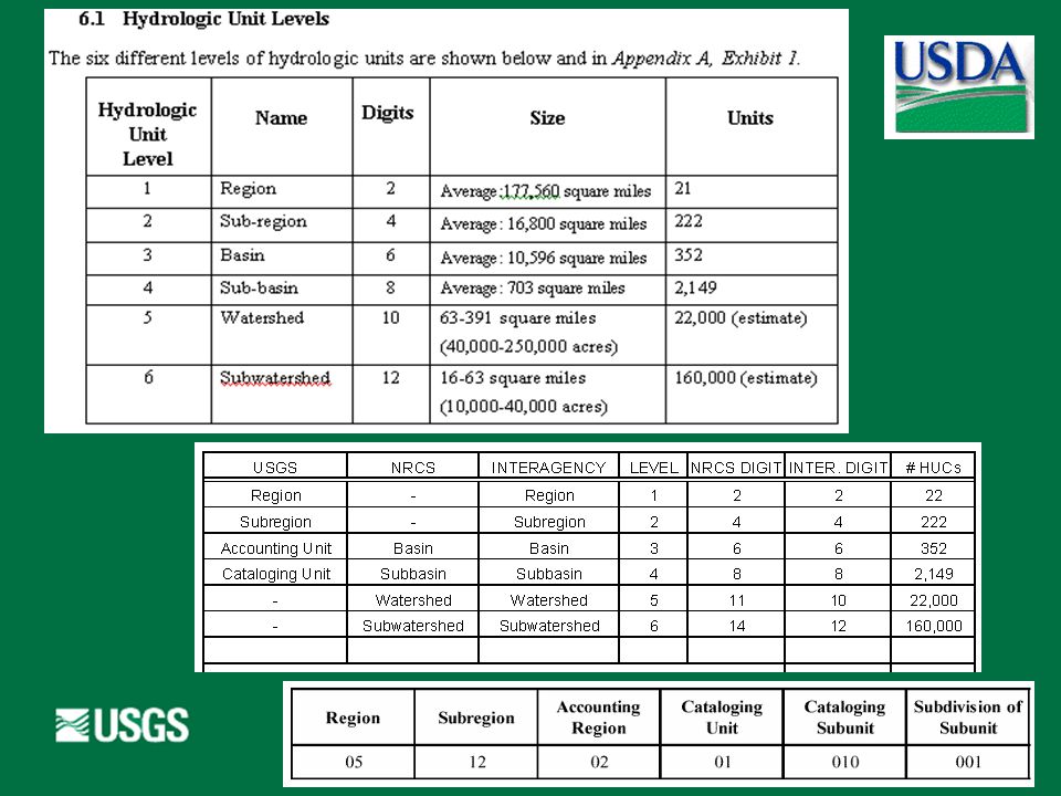
Seamless Data Not quad based Online access GIS ready Variable-resolution Feature-level metadata Update features as needed by transactions Versions Stable identifiers

8
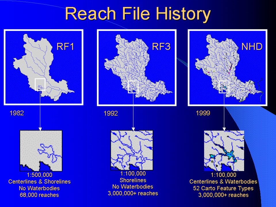
Reach Files – RF1, RF2, RF3, NHD

9
100K NHD and 24K NHD

10
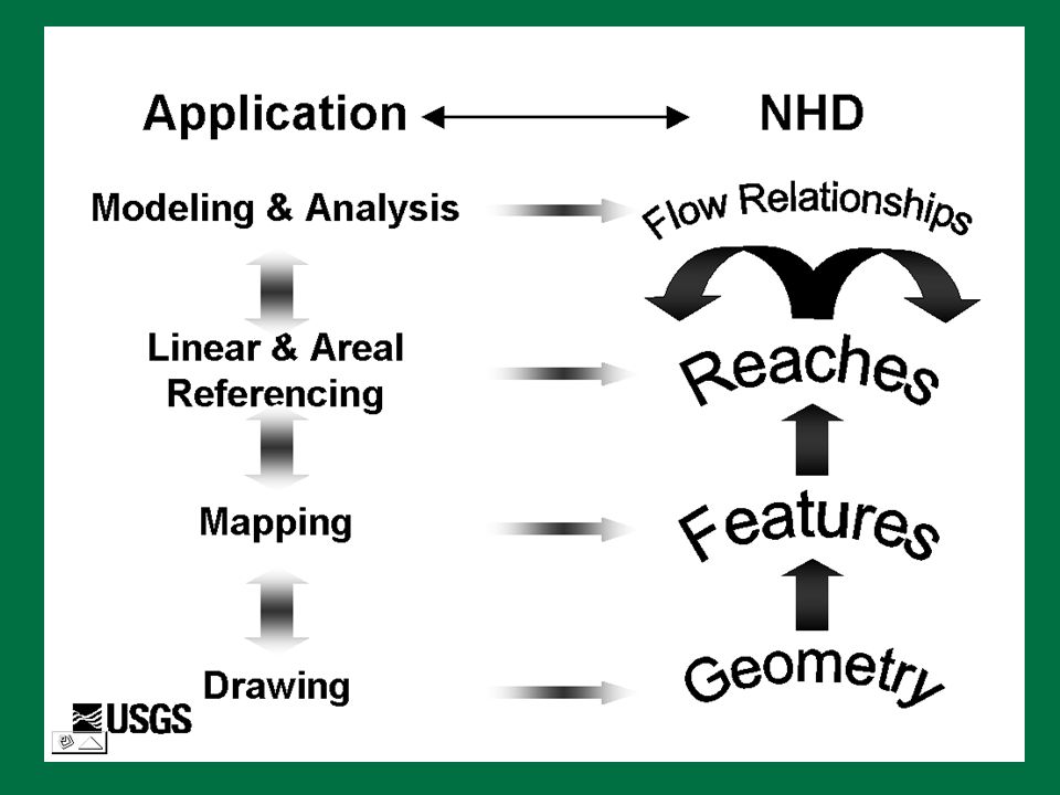
Main Components Features Reaches Flow relationships Geographic names Level paths Coordinates and measures Metadata

11
Features Represent bodies of water, paths through which water flows, and related hydrographic entities Contain the information found on USGS topographic maps: Stream network – streams, canals, other paths: 80% Water bodies – lakes, reservoirs, other areas: 14% Landmarks – dams, bridges, geysers, other items: 6% Classified by feature type using: A five-digit feature code Text aliases for the feature code in a lookup table

12
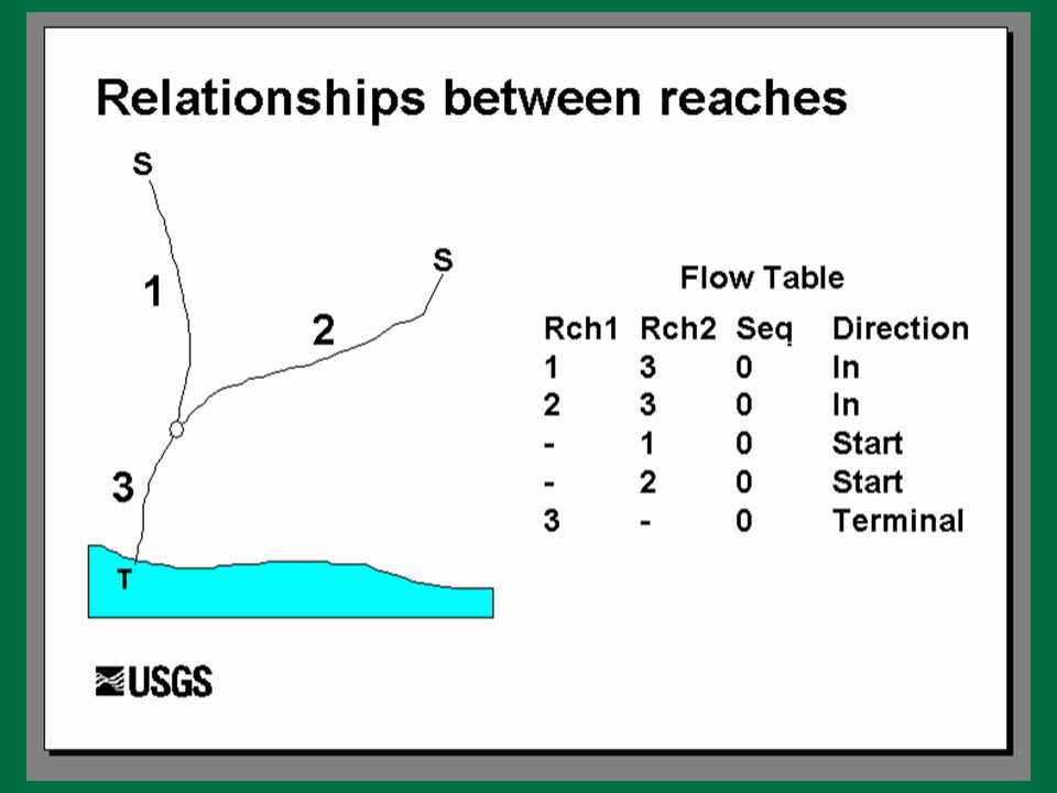
Reaches Segments of surface water with similar hydrologic characteristics Unique reach code identifies each reach Cataloging unit number + sequential number Three types of reaches implemented Transport (lines oriented in direction of flow) Coastline (lines oriented so water is on right) Waterbody
 Coastline (lines oriented so water is on right) Waterbody")
13
Reaches in RF3 and NHD From Spoerri, Miller, and Dabolt, 2000

14
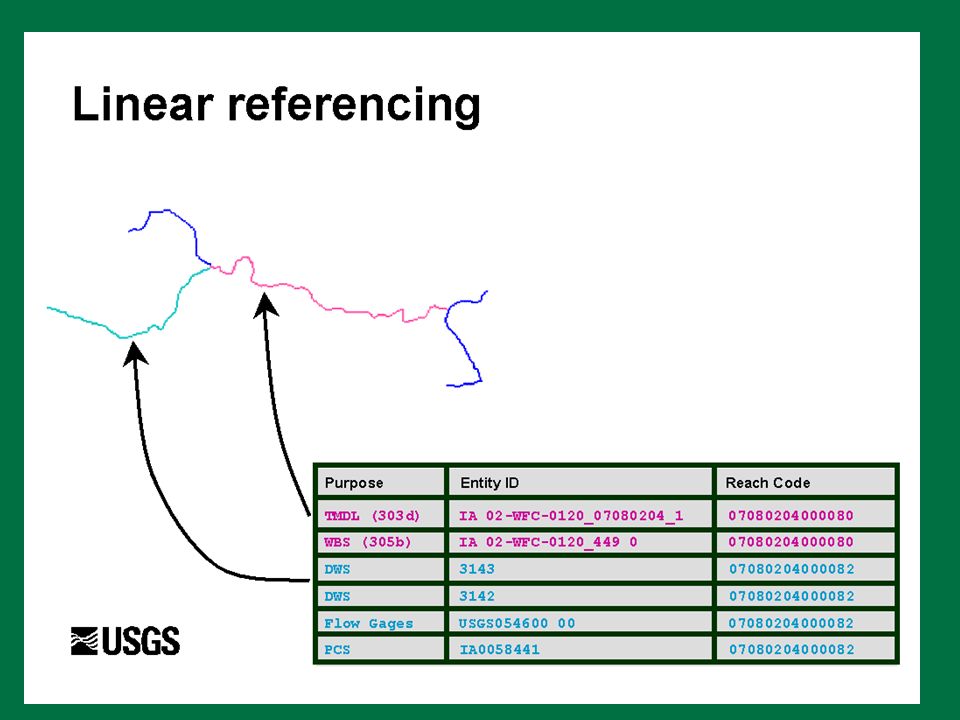
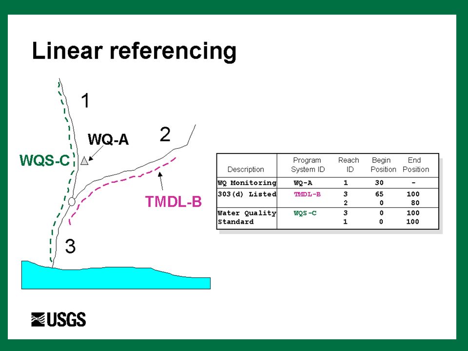
Geographic Names The proper name, specific term, or expression by which a particular geographic entity is known An identifier maintains a link to the Geographic Names Information System Reaches carry the geographic name most often; features only carry the name if they are not part of a reach.

15
Relationship Between Reaches Flow relationships link individual transport and coastline reaches to form the surface water drainage network Flow relationships describe The network connectivity between reaches The direction of water flow between transport reaches The traversal of the coastline along coastline reaches The order of termini of individual drainage networks along the coastline

17
Level Paths The ordered set of transport reaches that trace the main path for a given flow of water Identifies the main path to which a particular transport reach belongs Still working on implementation

18
Coordinates and Measures Latitude and longitude coordinates based on the North American Datum of 1983 Lengths and areas of features and reaches, computed from a projected coordinate system, supplied for convenience Elevations of surfaces and the associated stage for some features

19
Metadata Metadata, or data about data, describes the content, quality, condition or other characteristics of data Uses the FGDC metadata standard In the initial release of the data, there is metadata for The entire NHD Collections of features or reaches, normally organized by quadrangle digital update units for features cataloging unit digital update units for reaches

23
NHD – Applications and Related Programs How is NHD used? Support inventory, analysis, visualization, mapping, modeling... Water quality, flooding, fish...

25
NHD – Applications, Related Programs, and Tools (1) RIT - Reach Indexing Tool for NHD - georeferencing surface water databases to NHD BASINS - Better Assessment Science Integrating Point and Nonpoint Sources - integrated watershed environmental modeling CWAEM - Clean Water Act Effects Model - basic water quality modeling and economic analysis NAWQA - National Water-Quality Assessment Program NLFWA - National Listing of Fish and Wildlife Advisories
 RIT - Reach Indexing Tool for NHD - georeferencing surface water databases to NHD BASINS - Better Assessment Science Integrating Point and Nonpoint Sources - integrated watershed environmental modeling CWAEM - Clean Water Act Effects Model - basic water quality modeling and economic analysis NAWQA - National Water-Quality Assessment Program NLFWA - National Listing of Fish and Wildlife Advisories")
26
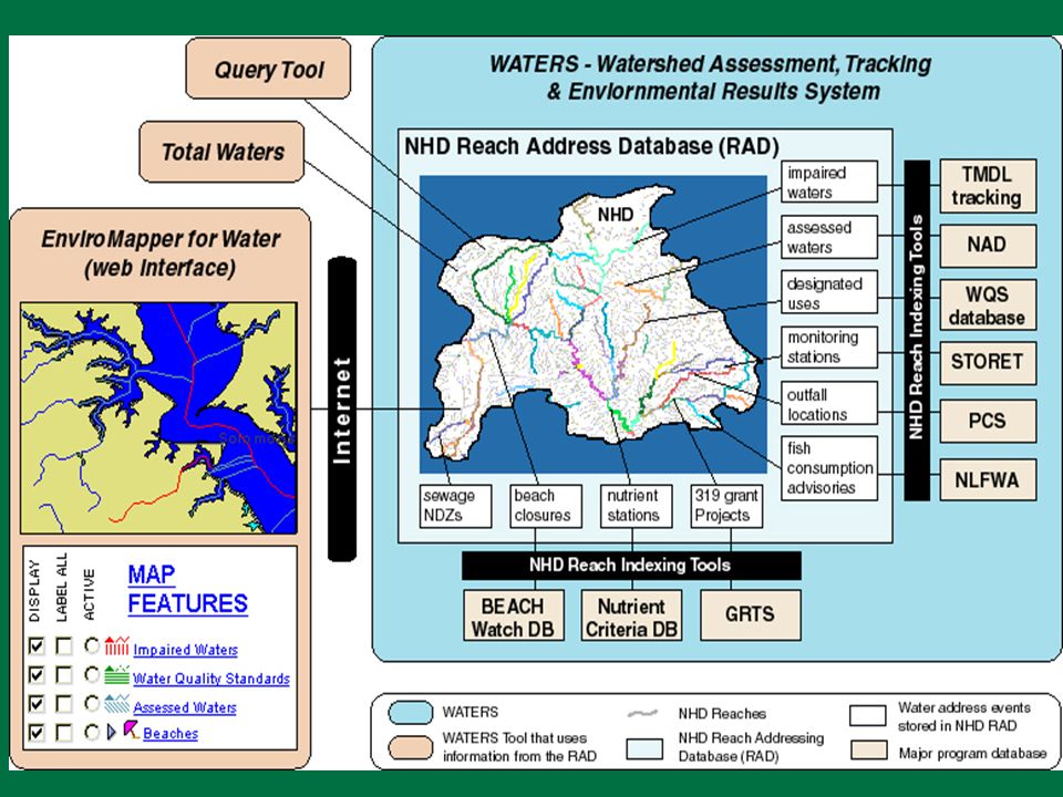
NHD – Applications, Related Programs, and Tools (2) WATERS - EPA Water Assessment, Tracking & Environmental Results Section 303d, Clean Water Act TMDL - Total Maximum Daily Load Section 305b, water quality assessment STORET - data STOrage and RETrieval system - water quality data repository
 WATERS - EPA Water Assessment, Tracking & Environmental Results Section 303d, Clean Water Act TMDL - Total Maximum Daily Load Section 305b, water quality assessment STORET - data STOrage and RETrieval system - water quality data repository")
27
NHD – Applications, Related Programs, and Tools (3) NRS - EPA National Recreation Survey NWIS - National Water Information System NWPCAM - National Water Pollution Control Assessment Model - modeling economic benefits related to water quality RIMDESS - River Management Decision Support System - modeling point and nonpoint discharges, nutrient routing and decay, and nitrogen loading in rivers and estuaries
 NRS - EPA National Recreation Survey NWIS - National Water Information System NWPCAM - National Water Pollution Control Assessment Model - modeling economic benefits related to water quality RIMDESS - River Management Decision Support System - modeling point and nonpoint discharges, nutrient routing and decay, and nitrogen loading in rivers and estuaries")
28
NHD – Applications, Related Programs, and Tools (4) SPARROW - Spatially Referenced Regression of Contaminants on Watershed Attributes WQSDB - Water Quality Standards Database USGS Gaging Station info linked to NHD - Dave Stewart of USGS WRD NHD Flow Volume and Velocity Estimator NHD Stream Order Tool
 SPARROW - Spatially Referenced Regression of Contaminants on Watershed Attributes WQSDB - Water Quality Standards Database USGS Gaging Station info linked to NHD - Dave Stewart of USGS WRD NHD Flow Volume and Velocity Estimator NHD Stream Order Tool")
29
NHD – Applications, Related Programs, and Tools (5) NHD ArcView Tool Kit NHD Names Update Tool USGS National Rivers Information Center - prototype GRT non-point source projects NPL - water-related National Priority List locations Aquatic GAP
 NHD ArcView Tool Kit NHD Names Update Tool USGS National Rivers Information Center - prototype GRT non-point source projects NPL - water-related National Priority List locations Aquatic GAP")
30
135 / 332 lakes are connected to the 1:24,000 NHD 197 / 332 lakes are considered seepage lakes Analysis of Isolated Lakes in Michigan

31
~ 10.2 miles upstream from Lake Michigan Indexing and Analysis of Dams in Michigan

32
Prototype of Aquatic Invasive Species Habitat

33
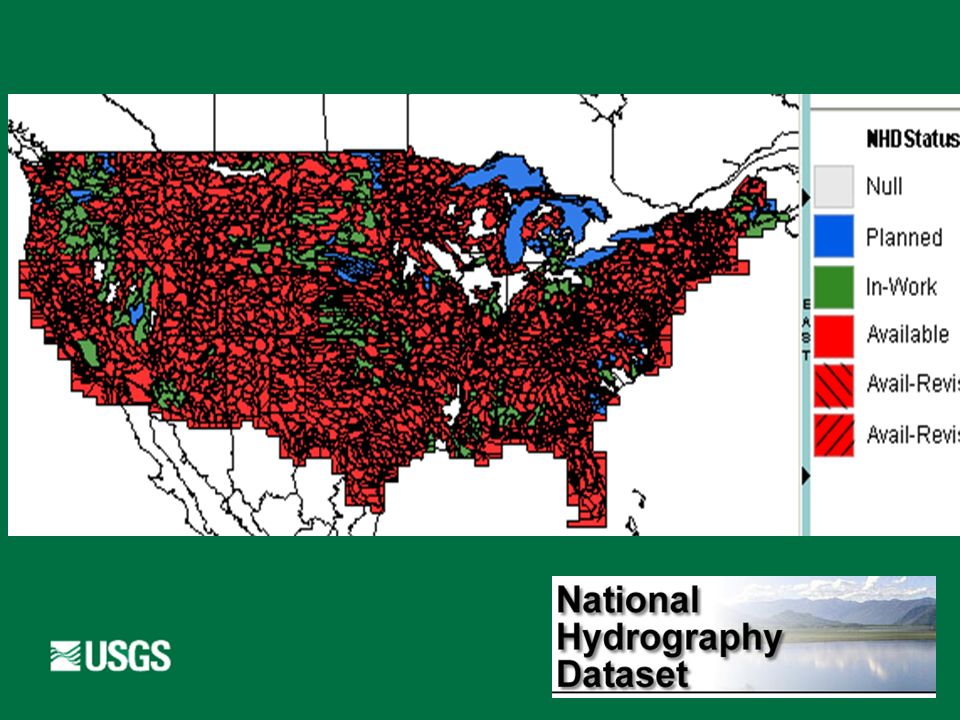
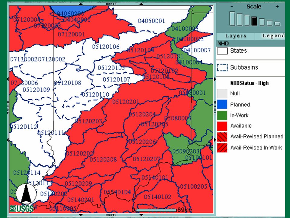
High Resoluton (24K) Status on April 7, 2002
 Status on April 7, 2002")
36
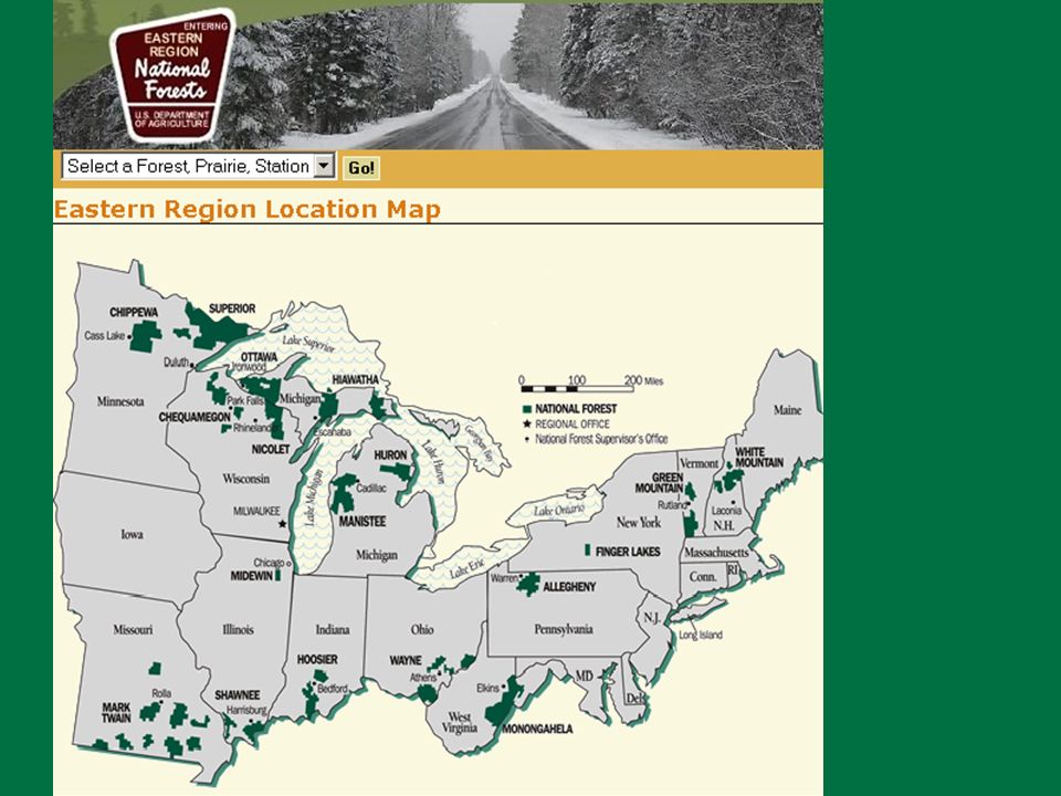
US Forest Service

38
NHDinARC GeoRelational Model (Use of trade, product, or firm names is for descriptive purposes only and does not imply an endorsement by the U.S. Government.)
.")
40
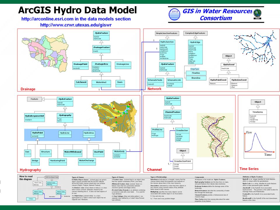
GeoDatabase Model Participating in the GIS Water Resources Consortium Sponsored by the Center for Research in Water Resources (CRWR) of the University of Texas at Austin and ESRI Initial focus is on design of a new GeoDatabase Model for Rivers and Watersheds for ArcGIS version 8 More information is available at http://www.crwr.utexas.edu/giswr (Use of trade, product, or firm names is for descriptive purposes only and does not imply an endorsement by the U.S. Government.)
.")
41
Related National Datasets NED – National Elevation Dataset EDNA – Elevation Derivatives for National Applications NWBD – National Watershed Boundary Dataset NLCD – National Land Cover Dataset USGS plans for National Map

42
National Elevation Dataset (NED)
")
43
Elevation Derivatives for National Applications (EDNA) [ Formerly National Elevation Dataset – Hydrologic Derivatives (NED-H) ]
![Elevation Derivatives for National Applications (EDNA) [ Formerly National Elevation Dataset – Hydrologic Derivatives (NED-H) ]](http://images.slideplayer.com/24/7420822/slides/slide_43.jpg "Elevation Derivatives for National Applications (EDNA) [ Formerly National Elevation Dataset – Hydrologic Derivatives (NED-H) ]")
44
National Watershed Boundary Dataset (NWBD) Integrated with NED and NHD
 Integrated with NED and NHD")
45
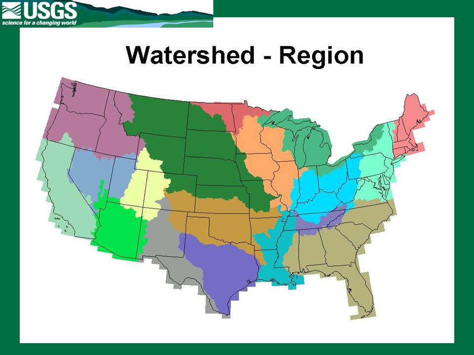
Hydrologic Units

49
National Land Cover Dataset (NLCD) Urban Farmland Pasture Orchard Row crops Water Barren Forest …
 Urban Farmland Pasture Orchard Row crops Water Barren Forest …")
50
Homeland Security

51
Indiana IDNR IDEM USGS WRD & NMD US Forest Service

52
Indiana High-Resolution National Hydrography Dataset Indiana High-Res NHD is part of Indiana’s I-Team effort for Framework development.

53
NHD Stewards The NHD is a living dataset Revision updates needed Quality updates needed Organizations closest to the hydrography are most aware of ground truth Such organizations should have the opportunity to serve as stewards The USGS will assist

54
NHD Partnerships LocalState Federal

55
National Geospatial Programs Office A Unified Approach to the NSDI Align USGS national geospatial activities and responsibilities Federal Geographic Data Committee Geospatial One Stop National Map National Atlas Reaffirm the direction of individual activities Expand partnership offices Assess USGS geospatial products and services

56
A Bold Step for the NSDI: The National Geospatial Programs Office Coordination, standards, policy – Federal Geographic Data Committee Discovery and access – Geospatial One Stop Integrated base data – The National Map Coordination & Standards Data Discovery & Access Consistent & Current Content

59
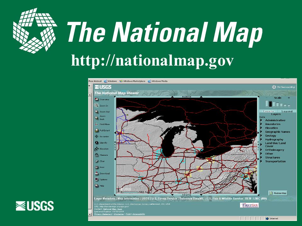
http://nationalmap.gov
60
The National Map Distributed set of consistent, integrated, continually maintained, basic spatial data for the United States. Serve as the Nation's topographic map for the 21 st century.

61
The National Map: Data Themes Orthorectified imagery Land cover Elevation Transportation (road, rail, other) Hydrography Structures Boundaries (political & admin) Geographic names
 Hydrography Structures Boundaries (political & admin) Geographic names")
62
The National Map: Characteristics (1) Seamless not quad based Current to days or weeks, not years Basic spatial data Foundation for additional data stable feature identifiers as Velcro reach codes, address ranges, linear referencing
 Seamless not quad based Current to days or weeks, not years Basic spatial data Foundation for additional data stable feature identifiers as Velcro reach codes, address ranges, linear referencing")
63
The National Map Characteristics (2) Digital data and paper maps GIS ready User friendly Online access, web accessible, 24-7 Accurate, best available Public domain, but link to other data Standardized, consistent, modern datums
 Digital data and paper maps GIS ready User friendly Online access, web accessible, 24-7 Accurate, best available Public domain, but link to other data Standardized, consistent, modern datums")
64
The National Map: Characteristics (3) Integrated themes Continually maintained Transactional updates Feature metadata Roll back to versions for any point in time Based on partnerships Fed by state & local data and knowledge National coverage Variable resolution
 Integrated themes Continually maintained Transactional updates Feature metadata Roll back to versions for any point in time Based on partnerships Fed by state & local data and knowledge National coverage Variable resolution")
65
U.S. Department of the Interior U.S. Geological Survey

68
http://nationalmap.gov
69
Ask USGS Earth Science Information Center (ESIC) Email ask@usgs.gov Phone 1-888-ASK-USGS Web http://ask.usgs.gov Order data using Earth Explorer at http://earthexplorer.usgs.gov
 Phone ASK-USGS Web Order data using Earth Explorer at")
70
National Hydrography Dataset National Database Meets NSDI and FGDC Objectives Technology Available Data Standard Meeting Multiple User Needs Future Applications Support Feature Based Model Framework for Additional Data Flexible Maintenance Mechanism

71
Almost Done Monthly NHD Newsletter USGS Geodata Liaison for Indiana Indiana NHD Workshop with Jeff Simley

73
NHD Home Page and Help Site National Hydrography Dataset site http://nhd.usgs.gov NHD Tech Support http://nhd.usgs.gov/techsupport.html nhd@usgs.gov

Similar presentations


, Peter Ilieve, Ken Gilland, Bill Cooter (RTI International) Bill Kramer,>")

>")
 Project MINI – WORKSHOP Thanks to… Susan Phelps, AECOM ; Jeff Simley,>")
>")


 Anne Marie Miller, RTI International (presenter) Michael Plastino, US EPA, Office of Water Thomas.>")

