Download presentation
Presentation is loading. Please wait.

1
Geographical names in the Dutch Topographical Maps Nico Bakker Department Research & Development Topografische Dienst

2
Production overview Aerial Photographs TOP10vector Terrain Reconnaissance Photogrammetry Updated Aerial Photograph orthophoto digitising check TOP10vector

3
Pencomputer for reconnaissance

4
Interface (Microstation)
")
5
TOP10vector Topographic map 1:25.000

6
Specifications/Handbook Namenboek Topografische Dienst Handleiding Versie 2001.1

7
Explanation 2.1. Preface 2.1.2 Sources / general information 2.1.3 Use of deviated corps for populated places 2.1.4 Spacing of names of populated places 2.1.5 Description of quarters of towns and industrial areas Selection of names 2.2 Selection of names of farms or houses 2.3 Local names 2.4 Foreign names 2.5 Depth and depth line figures 2.6 Street names 2.7 Buildings 2.8 Elevation numbers and contour lines 2.9 Low water mark 2.10 Polder name Content Handbook (1)
.")
8
Sources (1) Current map Name on object or on board List of Dutch municipalities City maps and city guides Navigation documentation Handbook Nature reserves German and Belgian maps
 Current map Name on object or on board List of Dutch municipalities City maps and city guides Navigation documentation Handbook Nature reserves German and Belgian maps")
9
Sources (2) ObjectInformation Name MunicipalityOfficial name by law Place nameMunicipality Field nameMunicipality, local information, owners etc. Polder nameWaterboards CanalNavigation documentation River, stream,Waterboards, local information Road nameMunicipality, local information

10
3.1 General rules 3.2 Use of van hyphen 3.3 Use of capitals 3.4 Orthography of (farm)houses 3.5 Capitals in names of farms 3.6 Splitting names 3.7 Relation between types the corps 3.8 Frisian toponyms Content Handbook (2) Orthography
houses 3.5 Capitals in names of farms 3.6 Splitting names 3.7 Relation between types the corps 3.8 Frisian toponyms Content Handbook (2) Orthography")
11
Languages Dutch Frisian

12
Frisian and Dutch names

13
How to handle the 2 languages

14
Some translations

15
Reconnaissance of topographical names (1) 4.1 Reconnaissance 4.2 Preparation 4.2.1 Overview of sources 4.2.2 Description of information 4.3 Activities during field work 4.4 Documenting the name information 4.4.1 Documentation on the register 4.4.2 Documentation on the name model
 4.1 Reconnaissance 4.2 Preparation Overview of sources Description of information 4.3 Activities during field work 4.4 Documenting the name information Documentation on the register Documentation on the name model")
16
Preparation Documentation (letters, remarks,..) Road documentation Water documentation Old map(s) Foreign maps (border region) Exploring other sources (books, table, lists, etc.) …
 Road documentation Water documentation Old map(s) Foreign maps (border region) Exploring other sources (books, table, lists, etc.) …")
17
4.1 Reconnaissance 4.2 Preparation 4.2.1 Overview of sources 4.2.2 Description of information 4.3 Activities during field work 4.4 Documenting the name information 4.4.1 Documentation on the register 4.4.2 Documentation on the name model Reconnaissance of topographical names (2)
")
18
Reconnaissance Visiting official authorities (municipalities, water boards, etc.) Names on boards, signs, buildings, …. Street names Local people ….

19
4.1 Reconnaissance 4.2 Preparation 4.2.1 Overview of sources 4.2.2 Description of information 4.3 Activities during field work 4.4 Documenting the name information 4.4.1 Documentation on the register 4.4.2 Documentation on the name model Reconnaissance of van topographical names (3)
")
20
Documentation The source of the name is documented: Name of authority, persons, date, etc

21
Placing the names on the map 5.1General rules 5.1.1Caption 5.1.2Colour of the text 5.1.2Corps of the text 5.1.3Often used text 5.1.4Spacing 5.1.5Superior placing of letters and numbers 5.1.6Abbreviations

22
Letter family and type

23
Placing the names on the map 5.1General rules 5.1.1Caption 5.1.2Colour of the text 5.1.2Corps of the text 5.1.3Often used text 5.1.4Spacing 5.1.5Superior placing of letters and numbers 5.1.6Abbreviations

24
Tabel topographic objects

25
Abbreviations

26
Placing the names on the map 5.1General rules 5.1.1Caption 5.1.2Colour of the text 5.1.2Corps of the text 5.1.3Often used text 5.1.4Spacing 5.1.5Superior placing of letters and numbers 5.1.6Abbreviations

27
Use of colours at different maps 1:25,0001:50,000 1:100,0001:250,000 1:500,000 Blackyes Redyes Blueyes Brownyes Violetyes

28
Text types CAPITAL Normal Bold Half bold Italic Narrow S p a c e d

29
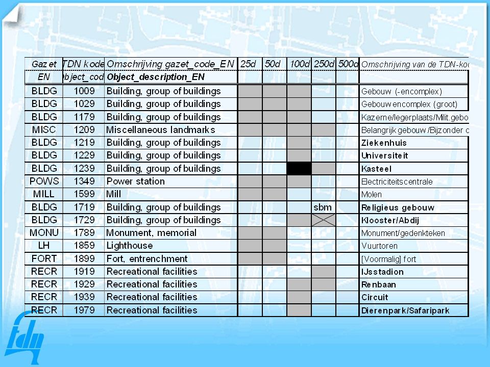
Geogr names at different map scales Overview with gazetteer codes

31
Production flow Preparation Sources research Field work Name documentation Digitising in Microstation Check-plot Correction Publishing maps

32
Dgn-file txt (1)
")
33
Map (1)
")
34
Dgn-file txt (2)
")
35
Map (2)
")
36
Gazetteers

37
Gazetteer 1:250,000

38
Gazetteercodes (1)
")
39
Gazetteercodes (2)
")
40
Development TOP10NL and smaller scales

41
Topographic basic objects Terrain Building Road segment Water segment Railroad segment Specific terrain element Administrative area Conservation area Geographic areaFunctional area

42
Topographic basic objects Entity Road segment Railroad segmentl Water segment Building Terrain Ispecial terrain element/construction Administrative area Conservation area Geographic area Functional area

43
Objects with NAME attribute

44
Special polygon for geographical names

45
Object characteristics: wegdeel

46
Shows attributes of an object

47
Meta-information for each object

Similar presentations
>")


 style is most commonly used to write papers and.>")

. 2.Add fields (automated.>")


