Download presentation
Presentation is loading. Please wait.

1
The National Resources Inventory (NRI)
Is a statistical survey, based on well-established scientific principles Designed & implemented to assess conditions & trends of soil, water, & related resources on non-Federal rural lands Conducted for USDA, by NRCS, in cooperation with the Iowa State University Statistical Laboratory What is the NRI? Who does it?

2
The National Resources Inventory (NRI)
Captures data on land cover & use, soils, soil erosion, wetlands, habitat diversity, selected conservation practices, & related resource attributes -- at 800,000 scientifically selected sample sites Purpose: To provide support for Agricultural & Environmental Policy Development and Program Implementation What the NRI does and overall purpose.

3
National Sample Density
Patterns West coast - more homogeneous wrt agriculture & more federal land (low sampling rates), CA ag lands East cost - ag lands & more heterogeneous Midwest - ag lands
, CA ag lands. East cost - ag lands & more heterogeneous. Midwest - ag lands.")
4
Primary Sample Unit (PSU)
")
5
CONTINUOUS NRI NRI 5-Year Cycles – 1982,1987, 1992 & 1997
In 2000 we converted from 5-year inventory to a continuous annual inventory The continuous annual inventory design: - 73,000 PSUs/year by remote sensing -14,000 PSUs by onsite methods.

6
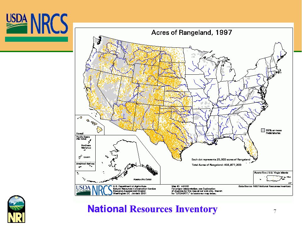
Example of output. Stress the large chunk of rangeland – of which not a lot is known.

8
Grazing Lands Nonfederal Grazing Lands Rangelands
45% of all nonfederal lands (*) Rangelands > 40% of all lands in Nation (#) * Excludes Alaska & Federal lands # Includes Alaska & Federal lands This slide tells more about the grazing land and rangeland resource- Foot notes are important here
 Rangelands. > 40% of all lands in Nation (#) * Excludes Alaska & Federal lands. # Includes Alaska & Federal lands. This slide tells more about the grazing land and rangeland resource- Foot notes are important here.")
9
National Academy of Sciences
ISSUES: Disagreement over status of rangeland, over analysis and assessment techniques, over extent of problems, etc. Recommendations to DOI and USDA included implement a coordinated & statistically valid national inventory to periodically evaluate health of Federal and nonfederal rangelands NRI is statistically valid for nonfederal range but proper data are not being collected From the Busby/Cos article- may not want this one for this crowd.

10
Plans Establishment of Analysis Team – concern re “Continuity and utility of data” (STC) Make sure we can monitor and look at trends over time Make sure that we can and do utilize all data Agency implementation of rangeland field protocols Many pilot studies; inter-agency development Federal government – National Cooperative Rangeland Study – DOI, USDA, SRM, others Conservation Effects Assessment Project (CEAP) Details plans- again may not want this one for this group.
 Details plans- again may not want this one for this group.")
11
NRI Rangeland Assessment - Objectives
In addition to the usual NRI objectives as stated in policy, use of the NRI (rangeland) field protocols will provide data that: can be used to further range science provide more knowledge about interactions among environmental, soil, and plant variables, and management practices This slide adds to the first list targeting the Rangeland field study.
 field protocols will provide data that: can be used to further range science. provide more knowledge about interactions among environmental, soil, and plant variables, and management practices. This slide adds to the first list targeting the Rangeland field study.")
12
NRI Rangeland Field Study-2003
Background: High level of interest in identifying resource concerns/treatment needs. High quality imagery available for 2000 NRI Utilize this resource to potential Team of ICCS leaders and other discipline specialists developed this module as a pilot attempt at photo-interpretation of resource concerns. Based on Soil, Water, Air, Plant and Animal concerns previously identified as critical components of a resource management system in NRCS Technical Guides.

13
Scientific Requirements – for NRI Rangeland Data
Continuous NRI To be conducted on the basis of rigorous, scientifically developed sample survey (e.g., statistical) principles and protocols [Policy] Features prescribed mixture of data collection types [on-site; PI; satellite] & full QA program Timely, credible, useful data Move from qualitative/subjective measures to quantitative/objective [National Academy] Last word on scientific nature of the NRI – leading to next segment on Process and protocols of the 2003 NRI Rangeland Inventory.
 principles and protocols [Policy] Features prescribed mixture of data collection types [on-site; PI; satellite] & full QA program. Timely, credible, useful data. Move from qualitative/subjective measures to quantitative/objective [National Academy] Last word on scientific nature of the NRI – leading to next segment on Process and protocols of the 2003 NRI Rangeland Inventory.")
14
Sample Design for Field & Special Resource Studies
Use photo-interpretation sample First phase in multi-phase design Use historical information to design sample Borrow strength from photo-interp data in estimation Often requires extra stage in sampling Reduce study costs by selecting geographic clusters Example: select counties within states first, then PSUs Design of special studies is an interesting off shoot of the foundation small, natl or region Multi-phase design Large sample w/”cheap” msrmts Smaller (sub)sample w/more expensive measurements Used to balance operational & stat (precision) considerations Phase I: frame for Phase II
sample w/more expensive measurements. Used to balance operational & stat (precision) considerations. Phase I: frame for Phase II.")
15
NRI Rangeland Data Collection, NRCS
Preceded by a number of pilots in association with personnel from BLM/FS/USGS. Part of 3-year effort The 2003 data can not be used by themselves to obtain statistical estimates 2004 and 2005 data collection On-site data collection Standard facet of NRI; Monitoring Continue to work with other agencies and to pursue remote techniques Bob takes over!

16
2004 and 2005 2003 Sample/Non-Federal 2003- Pilot Year
600 Primary sampling units Across 110 counties in 17 states 2004 and 2005 2400 Primary sampling units/each year 19 States

17
Rangeland Inventory Oracle Data base (Source for historical data and storage for new submitted data) Front end machines Modem bank or Network access to mobile device PSU and associated historical to mobile computing device New data uploaded from mobile computing device All via modem or network connection

18
Computer-Assisted Survey Information Collection
Hand-held pen-based computer controlled input formats & navigation edit checking communication w/ central server & other peripherals Central warehouse sample data base, process metadata web pages: survey progress, interactive training, data views, instructions

19
CASI- (Computer Assisted Survey Instrument)
Paper worksheet with embedded rules, logic and communication capabilities. Key to high quality data

20
Equipment/Software Apple Newton Message Pads Model 2000/2100
Modem or Network connection* CASI (Range02.pkg) Rockwell PLGR (GPS) Cables, backpack Some specialized equipment (cover pole, soil stability test kit, tapes etc.) Background: High level of interest in identifying resource concerns/treatment needs. High quality imagery available for 2000 NRI Utilize this resource to potential Team of ICCS leaders and other discipline specialists developed this module as a pilot attempt at photo-interpretation of resource concerns. Based on Soil, Water, Air, Plant and Animal concerns previously identified as critical components of a resource management system in NRCS Technical Guides.
 Rockwell PLGR (GPS) Cables, backpack. Some specialized equipment. (cover pole, soil stability test kit, tapes etc.) Background: High level of interest in identifying resource concerns/treatment needs. High quality imagery available for 2000 NRI. Utilize this resource to potential. Team of ICCS leaders and other discipline specialists developed this module as a pilot attempt at photo-interpretation of resource concerns. Based on Soil, Water, Air, Plant and Animal concerns previously identified as critical components of a resource management system in NRCS Technical Guides.")
21
PSU Data/General Entry for data collection team members and job titles. PSU ID information displayed for information.

22
Locating the Point, Land Cover and Transect Ends
Navigation to point location using GPS Entry of appropriate land cover/use opens up rest of data entry screens. Transect ends were also captured using GPS – not likely in 2004.

23
Plot Layout and Design Intersect at the NRI sample point
Intersect at the NRI sample point Two 150 ft transects oriented NW- SE and NE – SW. North, south, east and west quadrants are identified for some types of data collection.

24
Landscape and Soils Landscape and soil data elements. Choice lists for most NASIS SSAID and MUSYM brought forward from 2001 NRI. Soil Component name and ID optional depending upon make-up of data collection team.

25
Ecological Site Information
Choice lists for all data elements. Historic 1992 Ecological site brought forward for information Existing list of current Ecological site numbers and names also provided as choice list.

26
Rangeland Health Rangeland health protocol (same as in BLM/NRCS publication) Two screens Summary information provided on set II screen.

27
Noxious Weed and Invasive/Alien Plants
Sub-list of noxious and invasive or alien plants is created from the two provided plant data bases Record species by quadrant along with an estimate of degree of invasion (from choice list). On board data bases include: NRCS plant data base National noxious weed data base Plants can be sorted by common or scientific name. Plant symbol is displayed as the code.
. On board data bases include: NRCS plant data base. National noxious weed data base. Plants can be sorted by common or scientific name. Plant symbol is displayed as the code.")
28
Disturbance Indicators
Record presence or absence of a number of past or present disturbances. Two screens.

29
Conservation Practices (from NRCS technical guide)
Record presence or absence of a number of conservation practices Three screens

30
Conservation Treatment Needs
This is retained from the 1992 NRI. Likely will change to resource concerns as listed in NRCS technical guides in 2004.

31
Soil Stability Indictor
A soil aggregate stability test which provides information on the degree of soil structural development and erosion resistance. This test measures the stability of the soil when exposed to rapid wetting. Involves some special equipment which is provided to data collection teams. Ratings 0- 6 with 0 as unstable and 6 as % of ped remains after 5 dips.

32
Rangeland Inventory

33
Line Point Transects for Cover Composition
Rapid , accurate method for quantifying species composition, ground cover, litter, rocks and biotic crusts. Completed at 3 foot intervals along transects. Sub-list of plants can be created by the user from the large National plants database. Top, basal, and NS layer must be entered. Up to 6 canopy species could be entered prior to the basal layer.

34
Line intercept Transects for Basal and Canopy Cover
Provides an estimate of basal and canopy gaps along both transects 1 foot or larger. Large gaps between plants are important indicators of potential wind and water erosion and weed invasion. Enter beginning an end of gap to the nearest 0.1 of a foot.

35
Gap Examples Basal gaps Canopy gaps

36
Cover, Density and Height (Cover pole)
Provides an estimate of cover density along both transects at pre-determined intervals (left column). Visual obstruction readings are made at 10 foot intervals along each transect.. Right most column for estimate of canopy height. Observations made with the cover pole will allow users to reduce complex vegetative conditions found in nature to simplified structures with which to conduct analyses. This will include estimates of both vertical (<5 ft.) and horizontal structural diversity on rangelands
. Visual obstruction readings are made at 10 foot intervals along each transect.. Right most column for estimate of canopy height. Observations made with the cover pole will allow users to reduce complex vegetative conditions found in nature to simplified structures with which to conduct analyses. This will include estimates of both vertical (<5 ft.) and horizontal structural diversity on rangelands.")
37
Cover Pole Transect line B Viewing pole A Y 39.4” offset X

38
Species Composition by Weight (Biomass)
Record all plant species and associated weight to the nearest gram. Enter information of yield reconstruction including dry weight percentage, percent ungrazed, percent of total growth, and any needed climate adjustment. Similarity index is also calculated.

39
Species Composition by Weight (Biomass)
")
40
Criterion 1- Soil Based Criterion 1: Conservation and Maintenance of Soil and Water Resources of Rangelands Land Cover /Use Landscape/ soils Ecological Site Rangeland Health Noxious Weed –Invasive./Alien Plants Disturbance Indicators Conservation Practices Conservation Treatment Needs Soil Stability Test Line Point- Cover composition. Line Inter. Basal and Canopy Cover Cover, Density and Height Species Composition by Weight Soil-based Indicators 1. Area and percent of rangeland soils with significantly diminished organic matter and/or high carbon:nitrogen (C:N) ratio. 2 2. Area and extent of rangelands with changes in soil aggregate stability. 1 3. Assessment of microbial activity in rangeland soils. 4. Area and percent of rangeland with significant change in extent of bare ground. 5. Area and percent of rangeland with accelerated soil erosion by wind or water. May be too much detail here but this slide lists NRI objectives.
 ratio Area and extent of rangelands with changes in soil aggregate stability Assessment of microbial activity in rangeland soils. 4. Area and percent of rangeland with significant change in extent of bare ground. 5. Area and percent of rangeland with accelerated soil erosion by wind or water. May be too much detail here but this slide lists NRI objectives.")
41
Criterion 1-Water Based
Criterion 1: Conservation and Maintenance of Soil and Water Resources of Rangelands Land Cover /Use Landscape/ soils Ecological Site Rangeland Health Noxious Weed –Invasive./Alien Plants Disturbance Indicators Conservation Practices Conservation Treatment Needs Soil Stability Test Line Point- Cover composition. Line Inter. Basal and Canopy Cover Cover, Density and Height Species Composition by Weight Water-based Indicators 6. Percent of water bodies in rangeland areas with significant changes in natural biotic assemblage composition. 7. Percent of surface water on rangeland areas with significant deterioration of their chemical, physical, and biological properties from acceptable levels. 2 8. Changes in ground water systems. 9. Changes in the frequency and duration of surface no-flow periods in rangeland streams. 10.Percent of stream length in rangeland catchments in which stream channel geometry significantly deviates from the natural channel geometry.

42
Criterion 2- (Indicators 11-15)
Criterion 2: Conservation and Maintenance of Plant and Animal Resources on Rangelands Land Cover /Use Landscape/ soils Ecological Site Rangeland Health Noxious Weed –Invasive./Alien Plants Disturbance Indicators Conservation Practices Conservation Treatment Needs Soil Stability Test Line Point- Cover composition. Line Inter. Basal and Canopy Cover Cover, Density and Height Species Composition by Weight 11. Extent of land area in rangeland. 1 12.Rangeland area by plant community. 2 13.Number and extent of wetlands. 14.Fragmentation of rangeland and rangeland plant communities. 15. Density of roads and human structures.

43
Criterion 2 (Indicators 16-20)
Criterion 2: Conservation and Maintenance of Plant and Animal Resources on Rangelands Land Cover /Use Landscape/ soils Ecological Site Rangeland Health Noxious Weed –Invasive./Alien Plants Disturbance Indicators Conservation Practices Conservation Treatment Needs Soil Stability Test Line Point- Cover composition. Line Inter. Basal and Canopy Cover Cover, Density and Height Species Composition by Weight 16. Integrity in natural fire regimes on rangeland. 17. Extent and condition of riparian systems. 18. Area of infestation and presence/absence of invasive and other nonnative plant species of concern. 1 19.Number and distribution of species and communities of concern. 20.Population status and geographic range of rangeland-dependent species

44
Criterion 3 Criterion 3: Maintenance of Productive Capacity on Rangelands Land Cover /Use Landscape/ soils Ecological Site Rangeland Health Noxious Weed –Invasive./Alien Plants Disturbance Indicators Conservation Practices Conservation Treatment Needs Soil Stability Test Line Point- Cover composition. Line Inter. Basal and Canopy Cover Cover, Density and Height Species Composition by Weight 21. Rangeland aboveground biomass. 2 22. Rangeland annual productivity 1 23. Percent of available rangeland grazed by livestock. 24. Number of domestic livestock on rangeland. 25. Presence and density of wildlife functional groups on rangeland. 26. Annual removal of native hay and non-forage plant materials, landscaping materials, edible and medicinal plants, and wood products.

Similar presentations


>")


