Download presentation
Presentation is loading. Please wait.

1
Class lectures available

2
World Lithospheric Plates
Source: After W. Hamilton, U.S. Geological Survey.

4
North American Plate Caribbean Plate
Source:

5
Source: http://woodshole. er. usgs

6
Source: http://woodshole. er. usgs

7
Hot Spot Volcanism Tectonic plates ‘drift’ over a ‘mantle plume’

8
Hot spot volcanism: tracking moving plates
![]()
9
Hot spot volcanism: tracking moving plates
Midway Island (Pacific Plate) ~ 25 Million years old, 2700 km from Hawaii 2700 km/25 Ma At what rate is the Pacific plate moving?
![]()
10
Plate Tectonics and the Rock Cycle
What drives plate tectonics? Rock Formation at Plate Boundaries

11
Mantle Convection Different rocks form in different environments

12
Source: http://www. gly. fsu

13
Overview Earthquakes–Basic Theory
Seismic Waves and Earthquake Severity Earthquake–Related Hazards and Their Reduction Earthquake Prediction and Forecasting Earthquake Control? Awareness, Public Response Further Thoughts on Modern and Future U.S. Earthquakes

14
Source: http://www. gly. fsu

15
Seismic Waves and Earthquake Severity
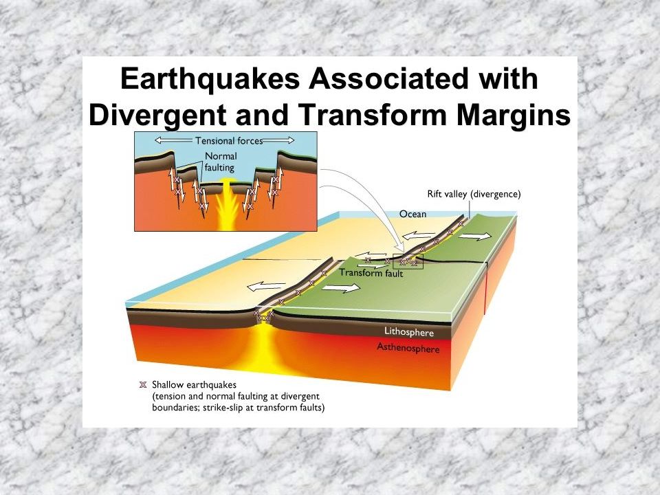
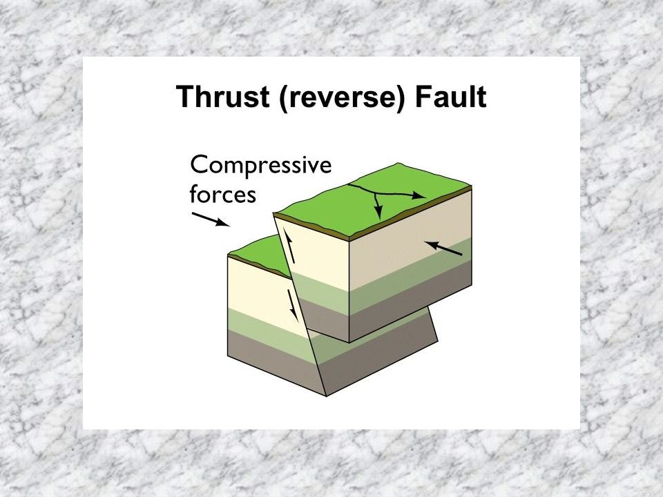
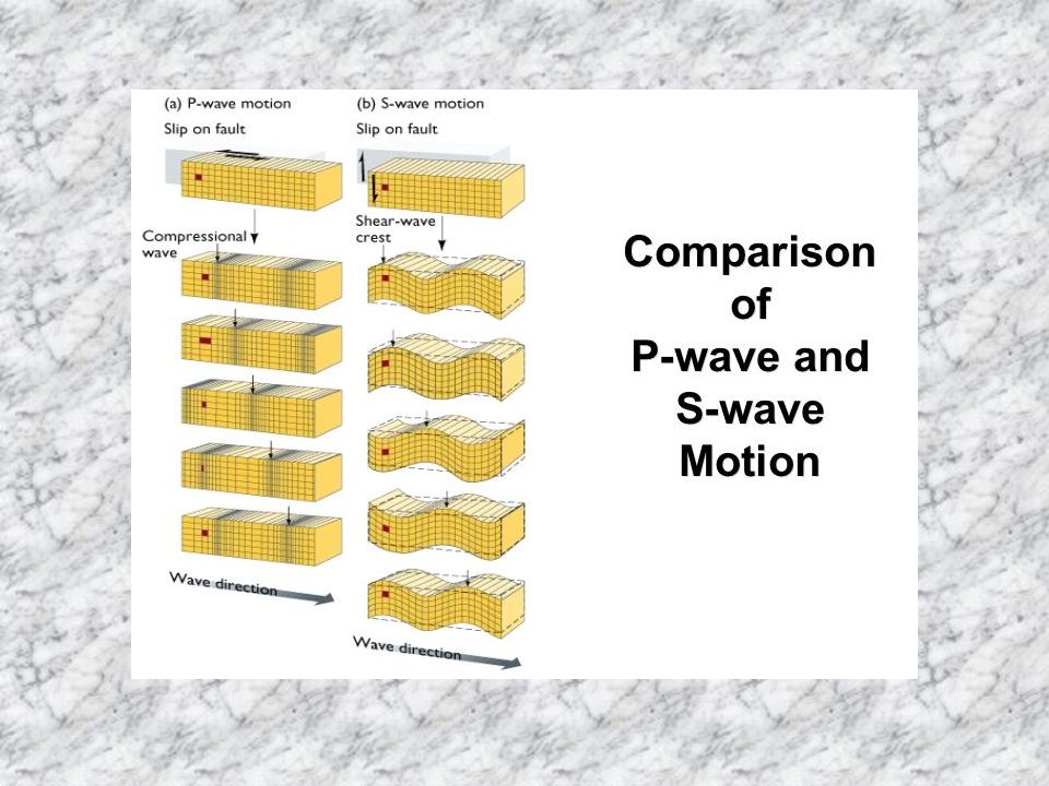
Locations faults occur Types of Faults Seismic Waves Locating the Epicenter Magnitude and Intensity

22
Source: http://www. gly. fsu

35
Earthquake–Related Hazards and Their Reduction
Ground Motion (shaking) Influenced by bedrock vs. sediments Ground Failure (landslides, liquefaction) Tsunamis and Coastal Effects Fire
 Influenced by bedrock vs. sediments. Ground Failure (landslides, liquefaction) Tsunamis and Coastal Effects. Fire.")
37
Ground Shaking — Loma Prieta Earthquake
Source: R.A. Page et. al., Goals, Opportunities, and Priorities for the USGS Earthquake Hazards Reduction Program, U.S. Geological Survey Circular 1079, p. 7.

38
Hollow Clay Brick Walls in Iran
Source:Photograph by M. Mehrain, Dames and Moore, courtesy of U.S. Geological Survey.

39
Timber-Frame Buildings in Turkey
Source:Photograph by Roger Bilham, courtesy of U.S. Geological Survey.

40
Landslide from Seattle Earthquake, 1965
Source:Photograph courtesy University of California at Berkeley/NOAA.

41
Effects of Soil Liquefaction, Japanese Quakes (Nigata), 1964
Source:Photograph courtesy of National Geophysical Data Center.

42
Sand Boils after Loma Prieta Earthquake
Source:Photograph by J. Tinsley, from U.S. Geological Survey Open-File Report

43
Collapse of I-880 1989 Loma Prieta Earthquake
Source:Photograph by D. Keefer, from U.S. Geological Survey Open-File Report

44
Marina District Damage from Loma Prieta Quake
Source:Photograph by M. Bennette, from U.S. Geological Survey Open-File Report

47
Tsunami Damage in Kodiak, Alaska
Source:Photograph courtesy of National Geophysical Data Center.

48
Tsunami Travel Times to Hawaii
Source: After U.S. Geological Survey.

49
Earthquake Prediction and Forecasting
Seismic Gaps Earthquake Precursors and Prediction Current Status of Earthquake Prediction The Earthquake Cycle and Forecasting

50
California Earthquake Probabilities Map
Source: After U.S. Geological Survey Circular 1079, fig, 15, p. 29.

51
Parkfield, CA: USGS Prediction of Earthquakes
Prediction: 1988 ± 5 years Source: Data from U.S. Geological Survey Circular 1079.

52
The “Earthquake Cycle” Concept
Source: After U.S. Geological Survey Circular 1079, fig 6, p. 15.

53
Earthquake Control? Releasing the energy: is it possible?
Observations: Denver, CO (1960’s) Fluid Injection to allow smaller slip
 Fluid Injection to allow smaller slip.")
54
Waste Disposal Correlated with Quakes in Denver
Source: Adapted from David M. Evans, “Man-Made Earthquakes in Denver,” Geotimes, 10(9):11-18, May/June Used by permission.
:11-18, May/June Used by permission.")
55
Earthquake: Public Response

58
Freeway Damage — 1971 CA Earthquake
Source:Photograph by E.V. Leyendecker, courtesy of U.S. Geological Survey.

59
Freeway Damage — 1994 CA Earthquake
Source:Photograph by M. Celebi, courtesy of U.S. Geological Survey.

60
Further Thoughts on Modern and Future U.S. Earthquakes
Areas of Widely Recognized Risk Other Potential Problem Areas

62
U.S. Seismic-Risk Map Source: Photo courtesy of U.S. Geological Survey National Seismic Hazard Mapping Project.

63
Seismic Waves Propagation
Source: After U.S. Geological Survey Professional Paper 1240-B.

64
Zones of Mercalli Intensity from Charleston Quake
Source:Data from U.S. Geological Survey.

65
Earthquake Scrapbook

66
Pancake-Style Collapse — 1985 Mexico City Quake
Source:Photograph by M. Celebi, USGS Photo Library, Denver, CO.

67
Mission district — San Francisco Earthquake, 1906
Source:Photograph by G.K. Gilbert, courtesy U.S. Geological Survey.

68
Source: http://www. gly. fsu

69
Fourth Ave Landslide — Anchorage, Alaska, 1964
Source:Photograph courtesy USGS Photo Library, Denver, CO.

70
Wreckage of Gov’t Hill School, Anchorage, 1964
Source:Photograph courtesy USGS Photo Library, Denver, CO.

71
Damage from 1886 Charleston, SC Earthquake
Source: Photograph by J.K. Hillers, USGS Photo Library, Denver, CO.

Similar presentations


 Chapter 10: Earthquakes (Part 3)>")

>")
 below surface.>")


 Outer Core is molten metal Rocky mantle (solid.>")

 what an earthquake is; b) what the elastic rebound theory.>")


>")


