Download presentation
Presentation is loading. Please wait.

1
Weather Services SECTION 3, & 7

2
PIREPS 3.2 UA PIREPS (UA) - observations from pilots in the cockpit. Provide the only means of directly observing cloud tops, icing, and turbulence. Transmitted in a prescribed format

3
PIREP UUA/UA Type of Report, /OV = LOCATION, /TM = TIME,
/FL = ALTITUDE/FLIGHT LEVEL, /TP = AIRCRAFT TYPE, /SK = SKY COVER, /WX = FLIGHT VISIBILITY AND WEATHER, /TA = TEMPERATURE, /WV = WIND, /TB = TURBULENCE, /IC = ICING, /RM = REMARK

4
PIREPS

5
PIREPS UA/UUA PIREPS (UA) - Any PIREP that contains weather phenomena not listed below, including low-level wind shear reports with air speed fluctuations of less than 10 knots UUA -URGENT PIREP - Tornadoes, funnel clouds, waterspout; severe or extreme turbulence, CAT; severe icing; hail; vocanic ash: low level wind shear 10 knots or move within 2000 feet of the surface; or anything considered by the controller to be hazardous.
 - Any PIREP that contains weather phenomena not listed below, including low-level wind shear reports with air speed fluctuations of less than 10 knots. UUA -URGENT PIREP - Tornadoes, funnel clouds, waterspout; severe or extreme turbulence, CAT; severe icing; hail; vocanic ash: low level wind shear 10 knots or move within 2000 feet of the surface; or anything considered by the controller to be hazardous.")
6
PIREPS ADDS http://adds.aviationweather.gov/pireps/ PIREP JAVA TOOL
7
ADDS PIREPS

8
PIREP REQUIRED ELEMENTS
Message type Location Time Altitude/flight level Type aircraft And at least one other element to describe the phenomena

9
PIREPS /OV - Location - Use VHF NAVAIDs or an airport using the three or four letter location identifier. Position can be over a site, at some location relative to a site, or along a route. Example /OV ABC; /OV KFSM090025; /OV OKC DFW; /OV KMWH-KGEG

10
/OV LOCATION

11
PIREPS /TM=TIME four digits in UTC Example /TM 0915 = 09:15 Z
/FL = ALTITUDE/FLIGHT LEVEL Three digits for hundreds of feet with no space between FL and altitude. If not known UNKN Example /FL095; /FL310 DURC OR DURD

12
PIREPS /TP = Type of Aircraft; if not known UNKN
Example /TP B737, /TP L35 /SK = Sky cover; Describes cloud amount, height of cloud bases, and height of cloud tops. Example /SK SKC040-TOP080; /SK SKC (PAGE 3-33)
")
13
/SK SKY CONDITION

14
/WX = FLIGHT VISIBILITY AND WEATHER
FV reported first in standard METAR symbols, then precipitation modifier Example /WX FV05SM -RA; /WX FV01SM SN BR; /WX RA, FV99SM = unrestricted

16
/WX FLIGHT VIS AND WEATHER

17
/WX FLIGHT VIS AND WEATHER

18
PIREPS WX TYPE AND SYMBOLS Listed on table 3-7 (review and memorize)
Notice BR mist = visibility great than or equal to 5/8 SM) What does /WX FV00SM +TSRAGR MEAN?
 What does /WX FV00SM +TSRAGR MEAN")
19
Flight visibility zero statute miles, thunderstorm, heavy rain, hail
PIREPS /WX FV00SM +TSRAGR Flight visibility zero statute miles, thunderstorm, heavy rain, hail

20
PIREPS /TA = TEMPERATURE (C) If below zero prefixed by a M /WV=WIND
example /WV 27045KT; /WV KT Wind on PIREPS = magnetic

21
/WV WIND

22
PIREPS /TB = TURBULENCE includes altitude if different from FL
/TB EXTRM; /TB OCNL LGT-MOD BLW 090; /TB MOD-SEV CHOP PIREP Turbulence reporting criteria Table 3-8 on page 3-38

24
/TB TURBULENCE

25
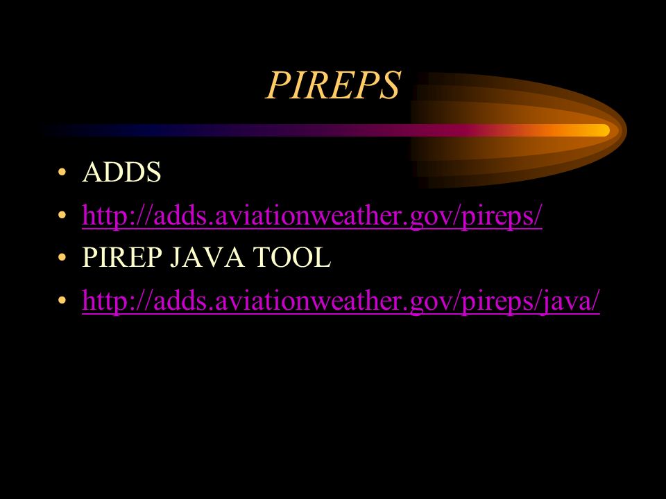
PIREPS /IC = ICING /IC LGT-MOD RIME; IC SEV CLR 028-045
PIREP Icing reporting criteria Table 3-9 on page 3-39 /RM = REMARKS Use free form to clarify the report putting hazardous elements first Example /RM LLWS -15KTS SFC-030 DURC RWY22 JFK

26
/IC ICING

27
/IC ICING TYPES

29
/RM /RM is used to report a phenomenon which is considered important but does not fit in any of the other groups

30
SKYSPOTTER When a PIREP is received from a pilot identifying themselves as a SKYSPOTTER aircraft, the additional comment /AWC is added at the end of the remarks section of the PIREP

31
PIREPS UA Example UA /OV MWH /TM 1600 /FL070 /TP B19 /SK BKN040-TOP065 /WX FV02 R H / TA -12 /WV /TB LGT /IC LGT-MDT RIME /RM MDT RAIN REVIEW PIREP EXAMPLE ON page 3-42 & 43

32
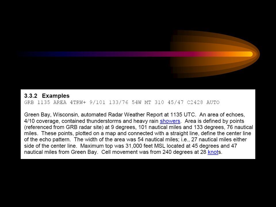
RADAR WEATHER REPORT (SD/ROB)
Include general areas of precipitation, including rain, snow, and thunderstorms, observed by radar. This is a textual product derived form the WSR-88D NEXRAD radar without human intervention. The resolution of this textual product is very coarse, up to 80 minutes old, and should only be used if no other radar information is available. All heights in an SD are MSL come out normally each hour +35 minutes

33
SD RADAR WEATHER REPORTS

34
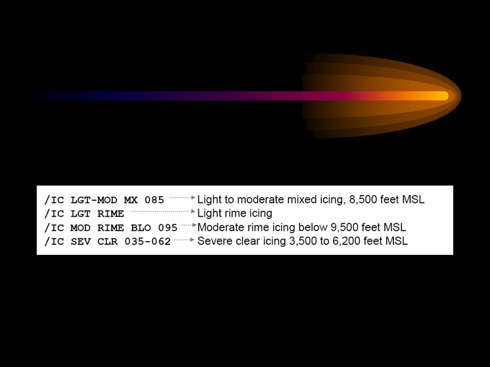
RADAR WEATHER REPORT (SD)
Include: Location - identifier and time of radar observation Configuration: Echo pattern - LINE (30 miles long), AREA, or CELL (example on Figure 3-12) Coverage - of the area in 10ths Intensity - (- = light, nothing=moderate, +=heavy, ++very heavy, X=intense, XX=extreme)
, AREA, or CELL (example on Figure 3-12) Coverage - of the area in 10ths. Intensity - (- = light, nothing=moderate, +=heavy, ++very heavy, X=intense, XX=extreme)")
36
SD PRECIP. Rain = R Rain Shower = RW Snow = S Snow Shower = SW
Thunderstorm = T

37
INTENSITY

39
RADAR WEATHER REPORT (SD)
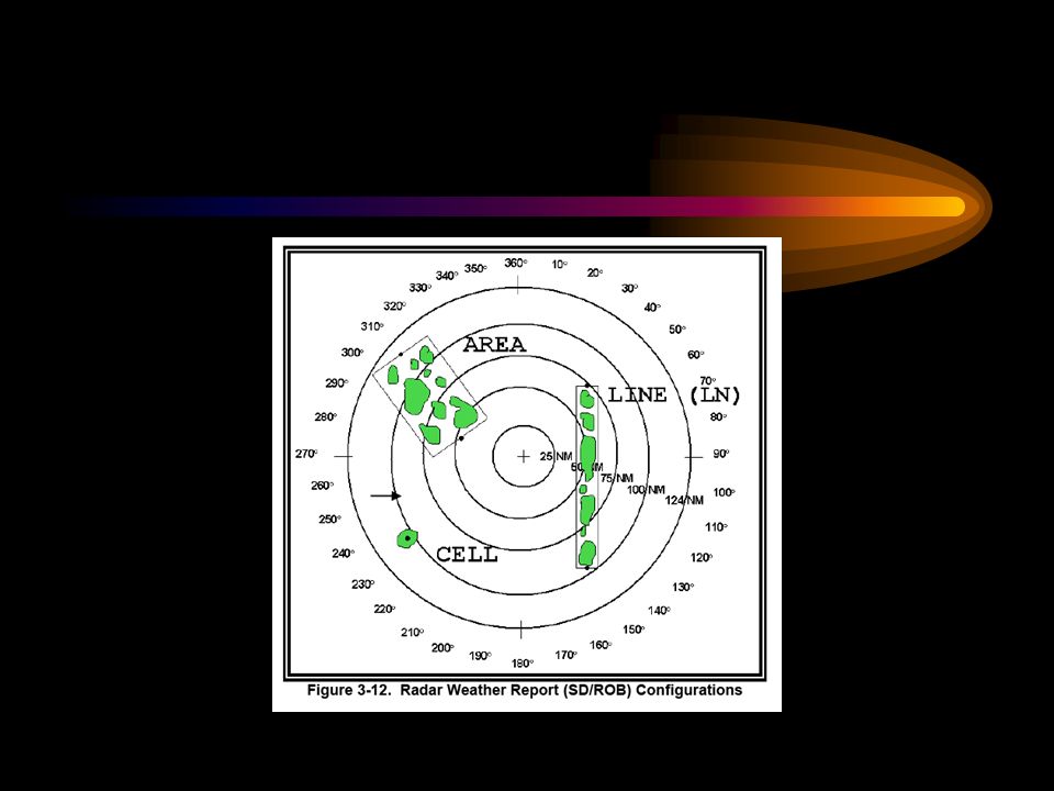
Azimuth, referenced to true north, and range in NM from the radar site, of points defining the echo pattern. For lines and areas, there will be two azimuth and range sets. Example (86/40 164/60) Dimension of echo (example 20NM wide) Cell movement (from speed knots) Max top and location (MT or MTS=satelite)
 Dimension of echo (example 20NM wide) Cell movement (from speed knots) Max top and location (MT or MTS=satelite)")
40
RADAR WEATHER REPORT (SD)
If the report is Automated=AUTO from WSR-88D weather radar data Digital section used for preparing radar summary chart. PPINE = equipment normal no echos PPINA = observation not available PPIOM = radar out for maintenance AUTO = report derived from an automated weather radar

41
RADAR WEATHER REPORT (SD)
OTX 1135 AREA 4TRW+ 9/ /76 54W MT /47 C22428 AUTO

44
RADAR WEATHER REPORT (SD)
")
46
RADAR NETWORK SITES

47
TAF (7-22) Used to be called a FT
Is a forecast of the expected weather conditions at an airport during a specific period (usually 24hrs) Issued four times a day for 24 hrs OR 30 HOURS periods (00Z, 06Z, 12Z, 18Z)
 Issued four times a day for 24 hrs OR 30 HOURS periods (00Z, 06Z, 12Z, 18Z)")
48
TAF FORMAT (FROM BOOK)
")
49
TAF Note In international and U.S. military TAFs contain forecasts of maximum and minimum temperature, icing, and turbulence (Fairchild AFB) TAF AMD KSKA VRB06KT 9999 SCT100 OVC150 QNH3010INS BECMG KT 9999 VCSH BKN025 BKN050 OVC QNH3008INS BECMG KT 9999 VCSH SCT025 BKN050 OVC QNH3009INS BECMG KT 9999 NSW BKN100 QNH3015INS T05/23Z TM01/13Z AMD 2155 Note in the NWS TAFs

50
TAF Contains: Type of report, ICAO identifier, Date/Time or origin, Valid period, Wind forecast, Visibility, Significant WX, Sky condition, LLWS, Forecast change indicators, Probability forecast

51
TAF P6SM = visibility greater than 6 SM
FM = FROM, is used when a rapid and significant change, usually occurring in less than 1 hour is expected. From that time until the next change group

52
TAF BECMG = BECOMING, gradual change in conditions expected over a period not to exceed 2 hours Example BECMG 2422/2423

53
TAF TEMPO = TEMPORARY- temporary fluctuations of wind, visibility, weather, or sky condition that are expected to last for generally less than an hour at a time for half the period TEMPO 2412/2416

54
TAF PROB30 OR PROB40 = PROBABILITY 30-39% for thunderstorms or precipiation to less than 50% of the area over that time. PROB /2423

55
TAF OLD FORMAT Example:
TAF KOKC Z KT 5SM BR BKN030 WS018/32030KT TEMPO /2SM BR FM KT P6SM SKC BECMG G20KT 4SM SHRA OVC020 PROB SM TSRA OVC008CB

56
TAF NEW FORMAT TAF KMWH Z 2500/ G25KT P6SM FEW090 SCT150 FM KT P6SM SCT150 FM KT P6SM SCT015 BKN070 FM KT P6SM VCSH SCT040 BKN080

57
NEW TAF FORMAT

58
TAF LOCATIONS

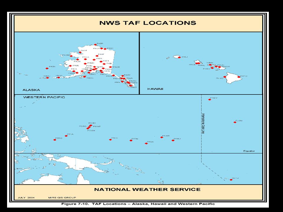
60
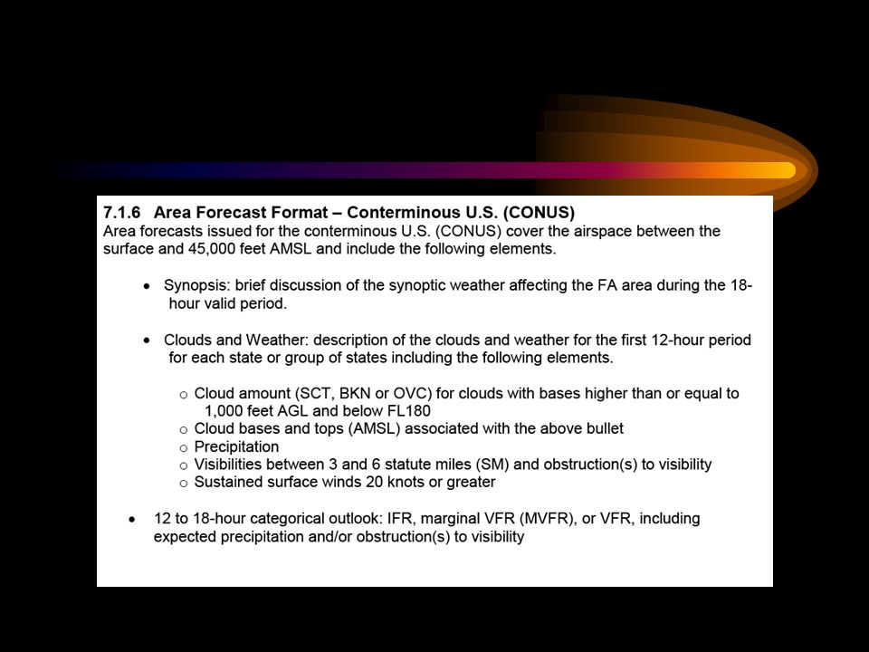
FA AVIATION AREA FORECAST
FA is a forecast of general weather conditions over an area the size of several states. It is used to determine forecast en route weather and to interpolate conditions at airports that do not have TAF’s issued. FA’s are issued 3 times a day for 6 different areas in the U.S. Surface to 45,000 ft conus U.S.

61
FAA REGIONS

62
FA ISSUANCE

64
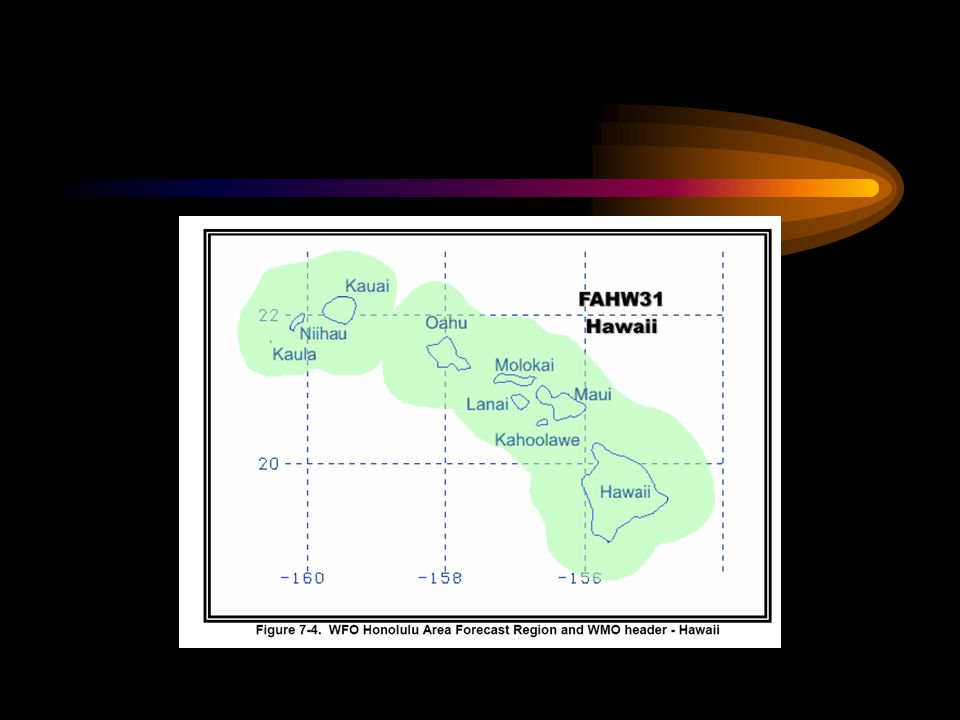
ALASKA

65
FA AVIATION AREA FORECAST
FA is comprised of four sections: 1 Communication and product header section 2. A precautionary statement section 3. Synopsis section 4. VFR Clouds/WX section

66
FA AVIATION AREA FORECAST
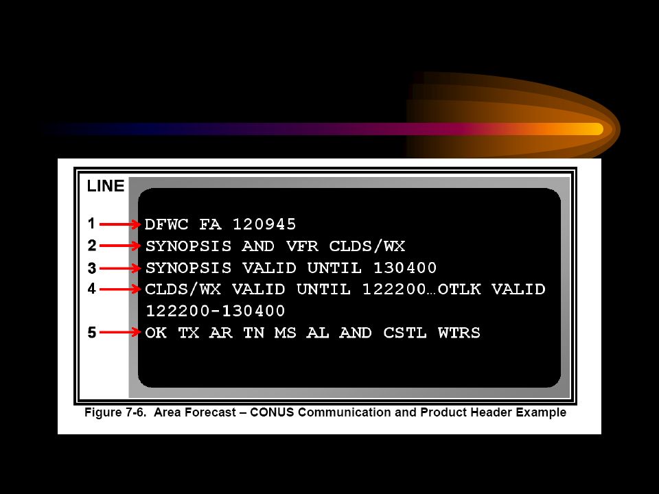
The area we are in is the SFO San Francisco area 1. Communication and Product header Identifies the office for which the FA is issued, the date and time of issue, the product name, the valid times, and the states and/or areas covered by the FA 2. Precautionary statements. Three statements are in all FA’s

68
FA AVIATION AREA FORECAST
SEE AIRMET SIERRA FOR IFR CONDS AND MTN OBSCN. TS IMPLY SEV OR GTR TURB SEV ICE LLWS AND IFR CONDS. NON MSL HGTS DENOTED BY AGL OR CIG.

69
FA AVIATION AREA FORECAST
Synopsis - brief summary of the location and movement of fronts, pressure systems, and circulation patterns for an 18-hr. period VFR Clouds and Weather - contains a 12 hr. specific forecast, followed by a 6 -hr outlook giving a total forecast of 18hr

70
SYNOPSIS SYNOPSIS...ALF..AT 21Z MOD/STG WLY WND NRN HLF FA AREA..MOD W WND SRN HLF. BY 15Z LOW OVER NRN VANCOUVER ISLAND WITH TROF EXTDG SWWD. STG WSW WND WA/NRN OR..MOD/STG W WND RMNDR FA AREA. SFC..AT 21Z TROF NERN CSTL WTRS OF WA-NWRN CSTL WTRS OF OR-CONTG SWWD. HIGH ABOUT 400NM SW LAX. BY 15Z CDFNT FAR NWRN WA-CONTG SWWD. HIGH JUST SW OF SRN CA CSTL WTRS.

71
CLOUDS & WEATHER WA E OF CASCDS CNTRL WA...BKN060 TOP 120. OTLK...MVFR CIG SHRA BR. ERN WA...OVC060 TOP 150 BKN CI. OCNL -SHRASN. OTLK...MVFR CIG RASN BR.

74
In-Flight WX advisories
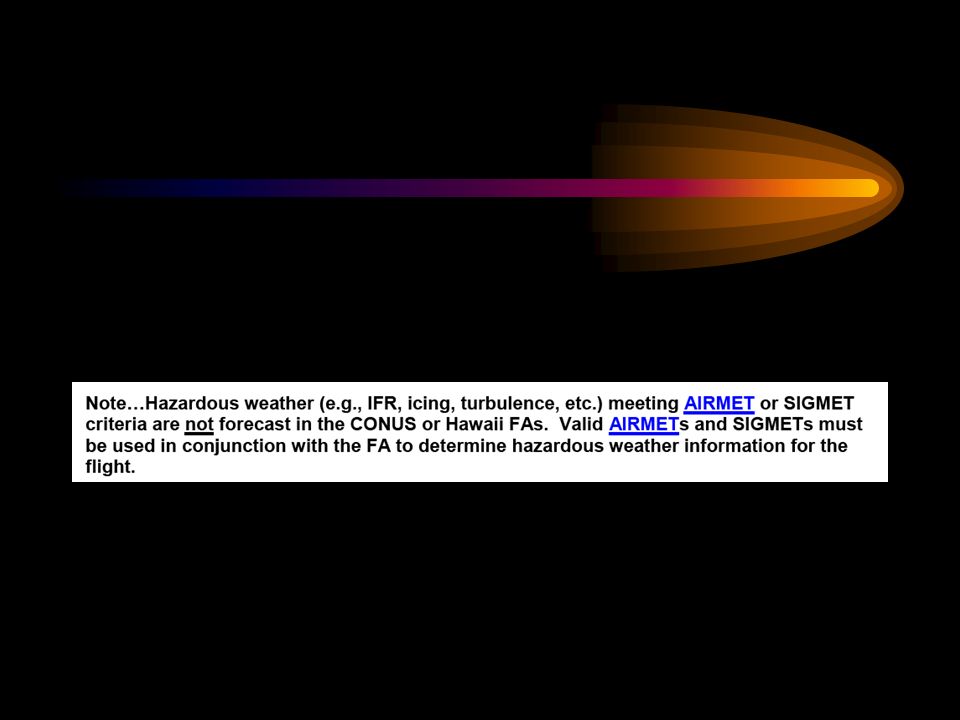
Are forecasts that advise en route aircraft of the development of potentially hazardous weather Three different kinds of in-flight wx advisories 1. Convective SIGMET (WST) 2. SIGMET (WS) 3. AIRMET (WA)
 2. SIGMET (WS) 3. AIRMET (WA)")
75
In-Flight WX advisories
All heights are MSL unless stated CIG Convective SIGMET (WST) - Are issued for any of the following A severe thunderstorm due to 1. Surface winds greater than or equal to 50kt, 2. Hail at the surface greater than or equal to 3/4 in. in diameter, 3. Tornadoes, 4. Embedded thunderstorms, 5. Line of thunderstorms, or 6. TS greater or = to VIP intensity level 4 affecting 40% or more of an area 3000 square miles.
 - Are issued for any of the following. A severe thunderstorm due to 1. Surface winds greater than or equal to 50kt, 2. Hail at the surface greater than or equal to 3/4 in. in diameter, 3. Tornadoes, 4. Embedded thunderstorms, 5. Line of thunderstorms, or 6. TS greater or = to VIP intensity level 4 affecting 40% or more of an area 3000 square miles.")
76
In-Flight WX advisories
Convective SIGMET (WST) - implies severe or greater turbulence, severe icing, and low-level wind shear Issued for eastern (E), central (C), and western (W) United States. Bulletins are issued hourly at H+55 Each new bulletin is identified with a number The text of the bulletin’s forecast is valid for up to 2 hours. (Pg 281)
 - implies severe or greater turbulence, severe icing, and low-level wind shear. Issued for eastern (E), central (C), and western (W) United States. Bulletins are issued hourly at H+55. Each new bulletin is identified with a number. The text of the bulletin’s forecast is valid for up to 2 hours. (Pg 281)")
77
In-Flight WX advisories
SIGMET (WS)- advises of nonconvective weather that is potentially hazardous to all aircraft 1. Severe icing, 2. Severe or extreme turbulence or clear air turbulence not associated with a TS 3. Dustorms, sandstorms, or volcanic ash lowering surface visibilities to below 3SM 4. Volcanic eruption The maximum forecast period is 6 hrs.
- advises of nonconvective weather that is potentially hazardous to all aircraft. 1. Severe icing, 2. Severe or extreme turbulence or clear air turbulence not associated with a TS. 3. Dustorms, sandstorms, or volcanic ash lowering surface visibilities to below 3SM. 4. Volcanic eruption. The maximum forecast period is 6 hrs.")
78
In-Flight WX advisories
Identified by alphabetic designators which inlude November through Yankee but exlude Sierra and Tango First issuance of a SIGMET with be labeled UWS (urgent weather SIGMET)
")
79
In-Flight WX advisories
Example UWS SIGMET PAPA 1 VALID UNTIL AR LA MS FROM STL TO 30N MEI TO BTW TO MLU TO STL OCNL SVR ICING 90 TO 130 EXPCE. FRZLVL 80 E TO 120 W. CONDS CONTG BYD 2100Z

80
In-Flight WX advisories
AIRMET (WA)- are advisories of significant weather phenomena but describe conditions at intensities lower than those which trigger SIGMETs. Are bulletins issued on a scheduled basis every 6 hrs. Issued for: moderate icing, Moderate turbulence, sustained surface winds of 30 kt. Or more, IFR clouds and visibilites affecting over 50% of the area at one time, extensive mountain obscurement
- are advisories of significant weather phenomena but describe conditions at intensities lower than those which trigger SIGMETs. Are bulletins issued on a scheduled basis every 6 hrs. Issued for: moderate icing, Moderate turbulence, sustained surface winds of 30 kt. Or more, IFR clouds and visibilites affecting over 50% of the area at one time, extensive mountain obscurement.")
81
In-Flight WX advisories
AIRMET - have fixed alphanumeric designators of: ZULU for icing TANGO for turbulence SIERRA for IFR and mountain obscuration Pg 284 example

82
WINDS ALOFT FORECAST FD
Forecasts are made twice a day based on 00Z and 12Z data for use during specific time intervals Can be both an observation or a forecast. Valid for a specific time Gives winds at 3000ft, 6000ft, 9000ft, 12,000ft, 18,000ft, 24,000ft, 30,000ft, 34,000ft etc. example winds and temperature at 9,000ft are written as = winds 270 degrees true and 25 knots temperature 0 degrees C

83
WINDS ALOFT FORECAST FD
No winds are forecast within 1500ft of station elevation, also no temperature are forecast for the 3,000ft level or for any level within 2,500 ft of station elevation. Above no negative C If wind speed is over 100 knots (or from knots) the wind speed will have 50 added to the direction Example wind 230 degrees T at 150 knots =7350 Wind less than 5 kt code as 9900 light and variable
 the wind speed will have 50 added to the direction. Example wind 230 degrees T at 150 knots =7350. Wind less than 5 kt code as 9900 light and variable.")
Similar presentations


 by Dr. Bradley Muller.>")


 USING TAFs The purpose of this presentation is to explain: What a TAF is; What a TAF is; How to register with.>")


 PILOT'S OPERATING HANDBOOK – POH DUATS – OR 1-800-WX BRIEF ADVISORY CIRCULAR COLD WEATHER.>")


 Loss of Control In Flight (“frequently.>")


, high and low pressure areas, air masses and fronts shows actual conditions.>")

 Under what conditions does low-level wind shear normally occur? 2) Describe.>")