Download presentation
Presentation is loading. Please wait.

1
DO NOW Tell a friend what you feel like on humid days. What time of year do we have humid days?

2
Chapter 2: “Understanding Weather”

3
Humidity Humidity – the amount of water vapor in air Air’s ability to hold water vapor changes as the temperature of the air changes. Increased temperature means the air can hold more water. Decreased temperature means the air can hold less water.

4
Relative Humidity Relative Humidity –ratio of water vapor in the air to the maximum amount the air can hold 2 factors that affect relative humidity: 1.Temperature 2.Water vapor in the air

5
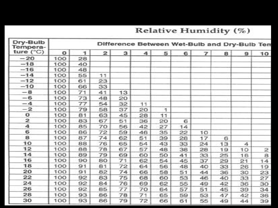
How to measure relative humidity? Psychrometer – a tool to measure relative humidity; contains a wet and a dry bulb. 1) Wet-bulb thermometer –bulb covered with wet cloth 2) Dry-bulb thermometer –bulb is dry Measuring Relative Humidity The difference in temperature readings between the 2 thermometers is used to determine the relative humidity.
 Wet-bulb thermometer –bulb covered with wet cloth 2) Dry-bulb thermometer –bulb is dry Measuring Relative Humidity The difference in temperature readings between the 2 thermometers is used to determine the relative humidity..")
6
Determining Relative Humidity

8
Water in the Air Dew Point –temperature when the air can no longer hold any more water (gas condenses to a liquid) Happens when relative humidity reaches 100%
 Happens when relative humidity reaches 100%")
9
DO NOW Write the answer to this question in the DO NOW section of your binder: What is the relative humidity if the temperature in the classroom today is 20 o C on the dry bulb and 17 o C on the wet bulb?

10
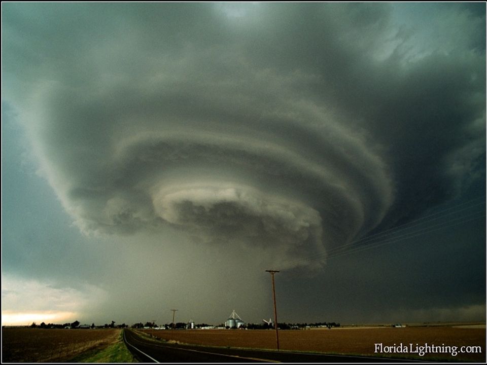
Clouds Clouds are groups of millions of tiny water droplets or ice crystals 2 Steps to Cloud formation: 1.Air rises 2.Air cools below the dew point, water droplets form

11
Water droplets – form when water condenses above 0 C Ice crystals – form when water condenses below 0 C Clouds Are Made Of…

12
Clouds 2) Shape: Stratus clouds (sheets, stripes, bands) Cumulus clouds (clumpy & puffy) Cirrus clouds Clouds are classified by: 1) Altitude Low clouds Middle clouds High clouds *NIMBO or NIMBUS = clouds producing precipitation*
 Shape: Stratus clouds (sheets, stripes, bands) Cumulus clouds (clumpy & puffy) Cirrus clouds Clouds are classified by: 1) Altitude Low clouds Middle clouds High clouds *NIMBO or NIMBUS = clouds producing precipitation*")
13
Low Clouds Found below 2,000 meters & made of only water droplets Three Types: 1)Stratus Clouds 2)Nimbostratus Clouds 3)Stratocumulus Clouds
Stratus Clouds 2)Nimbostratus Clouds 3)Stratocumulus Clouds")
14
“Overcast” Ill-defined edges In layers Block sun

15
Dark stratus cloud continuous rain Gray, rainy days

16
Lumpy & Low lying Patches of clouds with some blue between. Flat (Doesn’t look like popcorn)
")
17
Found between 2,000 meters and 6,000 meters They are made of water droplets or ice crystals Alto- means “middle” Four Types: 1)Cumulus 2)Cumulonimbus 3)Altocumulus 4)Altostratus Middle Clouds
Cumulus 2)Cumulonimbus 3)Altocumulus 4)Altostratus Middle Clouds")
18
White & Puffy Distinct edges popcorn-like; NOT flat

19
Big & Dark cumulus cloud Thunderstorm clouds Hail, tornadoes Tallest clouds anvil shaped top

20
Layered cumulus clouds Distinct cloud elements Patchy, scattered, or in bands

21
Uniform & Scattered Coverage Difficult to detect individual features

22
High Clouds Found above 6,000 m Temperature are very cold and made of ice crystals Cirro- means “high” Three Types: 1) Cirrus Clouds 2) Cirrocumulus Clouds 3) Cirrostratus Clouds
 Cirrus Clouds 2) Cirrocumulus Clouds 3) Cirrostratus Clouds")
23
Thin & feathery, wispy

24
Thick white wispy Distinct patchy or wavelike appearance

25
Sheet-like & cover entire sky Usually transparent (sun/moon can easily be seen).
.")
26
#1 #2 #3 #4 #5 #6 #7 #8 #9 #10

27
#1 #2 #3 #4 #5 #6 #7 #8

28
10 8 9 5 7 6 3 4 2 1

29
Recap!!! What is weather? What does it greatly depend on? Weather is the condition of the atmosphere at a certain time and place. It depends greatly on the amount of water in the air. What is the difference between humidity and relative humidity? Humidity is the amount of water vapor in the air. Relative humidity is the ratio of the amount of water vapor in the air to the maximum amount the air can hold.

30
Which two main cloud shapes are seen in this picture? Stratus Cumulus A B

31
Which two main cloud shapes are seen in this picture? Cumulus Cirrus C D

32
Clouds Stratus Clouds

33
Recap!!! What does nimbo or nimbus mean for clouds? It produces precipitation What does stratus mean for clouds? They are layered What are each of the following clouds made of? 1) Low Clouds 2) Middle Clouds 3) High Clouds 1) Water droplets only 2) Water droplets/ice crystals 3) Ice crystals only What are the two most common forms of precipitation? Rain and snow
 Low Clouds 2) Middle Clouds 3) High Clouds 1) Water droplets only 2) Water droplets/ice crystals 3) Ice crystals only What are the two most common forms of precipitation. Rain and snow.")
34
Air Masses Air Masses – a very large volume of air that has a certain temperature & moisture content

35
When air masses meet, the less dense air mass rises over more dense air mass. Since warm air is less dense, warm air masses usually rise above cold air masses Front– the place where two or more air masses meet

36
The four main kinds of fronts are: 1) Cold Fronts 2) Warm Fronts 3) Occluded Fronts 4) Stationary Fronts Fronts
 Cold Fronts 2) Warm Fronts 3) Occluded Fronts 4) Stationary Fronts Fronts")
37
Cold Fronts Cold air mass moves under a warm air mass and pushes the air up Cold air mass replaces warm air mass Moves quick & brings heavy precipitation

38
Warm Fronts Warm air mass moves in over a cold air mass leaving an area. Warm air mass replaces cold air as it moves away Bring light rain & followed by clear, warm weather

39
Cold air mass pushes Warm air mass replaces warm air mass away a cold air mass Visual

40
Warm air mass is caught between 2 cold air masses. Brings cool temperatures, rain, and snow Occluded Fronts

41
Cold air mass & a warm air mass move toward each other. Neither has enough energy to push the other away. Remain in same place causing cloudy weather Stationary Fronts

42
Occluded Front = warm air mass is trapped between two cold air masses, which move together and push warm air away Stationary Front = air masses stay in one place

43
Cyclone – air mass formed that has lower pressure than surrounding air. Air rises and cools Forecast: Clouds can form & cause rainy or stormy weather Anticyclone – air mass that has higher pressure than the surrounding air Air sinks and gets warmer Relative humidity decreases Forecast: Warm sinking air brings dry, clear weather Air Pressure and Weather

44
Cyclones and anticyclones can affect each other. Air moving out from anticyclones move towards areas of low pressure. This movement can form a cyclone.

45
What does air mass depend on? Recap!!! Water Content (Moisture) & Temperature What are the four different kinds of fronts? Cold Fronts Warm Fronts Occluded Fronts Stationary Fronts
 & Temperature What are the four different kinds of fronts. Cold Fronts Warm Fronts Occluded Fronts Stationary Fronts.")
46
Recap!!! What is the difference between Cyclones and Anticyclones? Cyclones lower pressure than surrounding air Cools as it rises. Anticyclones higher pressure than surrounding air Warms as it sinks. How are front and air masses related? A front is where two or more air masses meet. Therefore, without air masses…there would be no fronts.

52
What are the different types of severe weather?

53
1.) Thunderstorms
 Thunderstorms")
54
2. Hurricanes

55
3. Tornadoes

56
Thunderstorms –intense storm with strong winds, heavy rain, lightening, & thunder often along cold fronts Conditions required: 1)Warm, moist air near Earth’s surface 2) Unstable area of the atmosphere Thunderstorms
Warm, moist air near Earth’s surface 2) Unstable area of the atmosphere Thunderstorms")
57
4 Steps to a Formation of a Thunderstorm 1.cold air above warm air (unstable) 2.Warm air rises & mixes with cool air 3.water vapor condenses & forms cumulus clouds 4.If warm air keeps rising, clouds become dark cumulonimbus clouds
 2.Warm air rises & mixes with cool air 3.water vapor condenses & forms cumulus clouds 4.If warm air keeps rising, clouds become dark cumulonimbus clouds")
58
What is the difference between a severe thunderstorm watch and a severe thunderstorm warning? A severe thunderstorm watch is issued by the National Weather Service when the weather conditions are such that a severe thunderstorm is likely to develop. A severe thunderstorm warning is issued when a severe thunderstorm has been sighted or indicated by weather radar. At this point, the danger is very serious and everyone should go to a safe place, turn on a battery-operated radio or television, and wait for further information

59
Thunderstorm Safety Avoid touching metal objects Install metal lightning rods Find a low area away from trees Stay away from water

60
Number of days each year in which thunderstorms occur. Note hightest (90) in Florida.
 in Florida.")
61
Lightning 5 steps to the formation of lightning: 1.As a cloud grows bigger, parts begin to develop electrical charges Upper parts = positively charged Lower parts = negatively charged 2.When the charge difference gets big enough, electricity flows from one area to another (between the clouds) or to the ground
 or to the ground")
62
Lightening Video # 1Lightening Video # 1 Simulation of LighteningSimulation of Lightening

63
Thunder 4 Steps to the Formation of Thunder 1.When lightning moves through the air, the air gets very hot 2.hot air expands rapidly and vibrates 3.Vibrations release energy in the form of sound waves, called thunder.

64
Hurricanes Hurricanes – large, rotating tropical weather systems Wind speeds over 120 km/h Can be 160 km to 1,500 km in diameter and travel thousands of miles Most powerful storms on Earth Also called typhoons & cyclones Where are they formed? Over warm, tropical oceans

66
Hurricanes 5 Steps in the Formation of a Hurricane 1.Begins as a group of thunderstorms over tropical waters (Tropical Disturbance) 2. Winds traveling in different directions meet & cause the storm to spin (Tropical Depression) counterclockwise in the North clockwise in the South
 counterclockwise in the North clockwise in the South.")
67
Tropical Storm 3. Increases in strength, adds moisture, clouds, and wind (Tropical Storm)
")
68
Hurricane Formation continued 4. Gets stronger – adds moisture, clouds, and wind – as long as it is over warm water (Hurricane) 5. When they move over cold water or land they lose energy
 5. When they move over cold water or land they lose energy.")
69
Hurricane Video # 1Hurricane Video # 1 Hurricane Video # 2Hurricane Video # 2

70
Storm Surge Storm Surge- A rise in sea level that happens during a storm.

71
Hurricane Damage A storm surge from a hurricane can be up to 8 m high

74
Hurricane Safety Evacuate Move into the interior room and stay away from windows

75
Tornado rapidly whirling, funneled-shaped cloud reaches down from a storm cloud to touch Earth’s surface Usually brief, 15 minutes or less Wind speeds may reach 480 km/hr (230 mph) Counterclockwise in both the Northern and Southern Hemispheres
 Counterclockwise in both the Northern and Southern Hemispheres")
76
Tornadoes 1.Cold dry air meets warm moist air and causes wind to move in 2 directions (cold dry air meets warm moist air) 2.a layer of air in the middle to being to spin 3.The spinning column of air is turned to a vertical position by strong updrafts of air in the cloud. 4.The spinning column of air moves to the bottom of the cumulonimbus cloud and forms a funnel cloud. 5.The funnel cloud becomes a tornado when it touches ground.

78
Tornadoes Fewer than 1% of thunderstorms produce tornadoes About 75% of the world’s tornadoes happen in the United States Most happen in the spring and early summer Most last for only a few minutes Average wind speeds are between 120 km/h and 180 km/h Tornado Video # 1Tornado Video # 1 Tornado Video # 2Tornado Video # 2

79
Tornado Alley Where is Tornado Alley?? An area of the United States where tornadoes are most frequent Between Rocky & Appalachian Mountains z

80
Why is Central United States considered Tornado Alley? 90% of tornadoes hit this region of the US Cold, dry air from Canada/Rocky Mountains meets warm, moist air from the Gulf of Mexico and hot, dry air from deserts Tornado Alley

81
The core of Tornado Alley consists of: Texas Panhandle Oklahoma Kansas Nebraska South Dakota Colorado Eastern Plains Ohio Valley The southern Great Lakes The Tennessee Valley The lower Mississippi Valley Tornado Alley

82
A map Tornado Alley outlined. This area has been defined as the area where there has been approximately at least one significant tornado per day, per decade.

83
Tornado Safety Listen for watches & warnings Basement level, or to the middle room on ground floor Stay away from windows Lie in a ditch

84
Recap!!! Why do thunder and lightning usually happen together? When lightning moves through the air, the air gets very hot and expands rapidly. This makes the air vibrate which releases energy in the form of sound waves, called thunder. Where do most tornadoes happen. Why? 90% of tornados occur in Tornado Alley. This is a result of when the cold, dry air from Canada and the Rocky Mountains meets warm, moist air from the Gulf of Mexico and hot, dry air from deserts, which combines with atmospheric instability to produce intense tornadoes.

85
What type of energy powers hurricanes? How do hurricanes lose energy? They are powered by solar energy. The sun’s energy causes ocean water to evaporate. When they move over cold water or land they lose energy. Recap!!! 1)warm, moist air near Earth’s surface 2) an unstable area of the atmosphere Which two conditions are required for thunderstorms to form: A storm surge is a rise in sea level that happens during a storm. A hurricane can cause a storm surge to be 8 m high. What is a storm surge? Which type of severe storm is most commonly associated with this?
warm, moist air near Earth’s surface 2) an unstable area of the atmosphere Which two conditions are required for thunderstorms to form: A storm surge is a rise in sea level that happens during a storm. A hurricane can cause a storm surge to be 8 m high. What is a storm surge. Which type of severe storm is most commonly associated with this .")
Similar presentations