Download presentation
Presentation is loading. Please wait.

2
Edging Toward Interoperability Mélanie F. Meaux GO-ESSP: June 6-8, 2005 The Global Change Master Directory: A Directory of Earth Science Data & Earth Science-Related Services

3
Edging Toward Interoperability International Interoperability Standards Authoring Tools: web-based & off-line Controlled-Vocabulary Query Free-Text Query Open Application Programmer Interfaces (APIs) OAI/HTTP Harvesting Capabilities Metadata Converter Local Database Agent (LDA) OGC WMS Capabilities GCMD’s Prototype Mapserver Moving forward through …
 OAI/HTTP Harvesting Capabilities Metadata Converter Local Database Agent (LDA) OGC WMS Capabilities GCMD’s Prototype Mapserver Moving forward through …")
4
2004: ISO-19115 Geographic Information Metadata International Standard formalized - ISO-19115-2 Extensions for imagery and gridded data I. International Interoperability Standards – crosswalks among metadata standards Other formats: - Dublin Core Metadata Initiative (DCMI) & MARC21 - WMO Core Metadata - US Federal Geographic Data Committee (FGDC) Content Standard for Digital Geospatial Metadata (CSDGM) -Extensions for Remote Sensing Metadata (2002) - Directory Interchange Format (DIF) - European Directory of Marine Environmental Datasets (EDMED) - ROSCOP/CSR (Cruise Summary Report) - Ocean Data Acquisition System (ODAS)
 & MARC21 - WMO Core Metadata - US Federal Geographic Data Committee (FGDC) Content Standard for Digital Geospatial Metadata (CSDGM) -Extensions for Remote Sensing Metadata (2002) - Directory Interchange Format (DIF) - European Directory of Marine Environmental Datasets (EDMED) - ROSCOP/CSR (Cruise Summary Report) - Ocean Data Acquisition System (ODAS).")
5
Web User Search data set descriptions through GCMD search interface Retrieve metadata records portals Search data set descriptions through portals - virtual subsets of the directory Retrieve metadata records Search data service descriptions through GCMD search interface Retrieve metadata records Publish metadata through web- based & off-line tools DocBUILDER; Metadata records are stored off-line where they can be later submitted to GCMD GCMD Database /Server HTML DocBUILDER Translate existing records using Extensible Stylesheet Language Transformations (XSLT) Metadata Converter : Converts metadata records (e.g. FGDC) to GCMD’s Directory Interchange Format (DIF) Harvester : Retrieves, converts & exchanges metadata through HTTP or Open Archives Initiatives (OAI) servers 1 2 Metadata Tools A B C GCMD Interfaces Search/Publish Metadata Content Harvest existing records for exchange
 to GCMD’s Directory Interchange Format (DIF) Harvester : Retrieves, converts & exchanges metadata through HTTP or Open Archives Initiatives (OAI) servers 1 2 Metadata Tools A B C GCMD Interfaces Search/Publish Metadata Content Harvest existing records for exchange.")
6
View DIF in QA XML DIF/SERF MD Server Web User 2 DIF object process & validate against DTD Valid DIF object validate with MD software 3 4 1 DIF in DB insert into DB retrieve from DB & display (HTML, FGDC) 5 6 Life Cycle of the Directory Metadata Format In House / off-line The Life Cycle of the Directory Metadata Format XML DIF Schema can be found at http://gcmd.nasa.gov/Aboutus/xml/dif/dif.xsd
 5 6 Life Cycle of the Directory Metadata Format In House / off-line The Life Cycle of the Directory Metadata Format XML DIF Schema can be found at")
7
II. Authoring Tools: web-based & off-line HTML docBUILDER docBUILDER

8
DIF authors can now select from set of Geospatial and Temporal resolution range “valid” values. Vertical Resolution refers to both Altitude and Depth resolution. < 1 m 1 m - < 30 m 30 m - < 100 m 100 m - < 250 m 250 km - < 500 m 500 m - < 1 km 1 km - < 10 km 10 km - < 50 km 50 km - < 100 km 100 km - < 250 km 250 km - < 500 km 500 km - < 1000 km > 1000 km or > 10 degrees < 1 second 1 second - < 1 minute 1 minute - < 1 hour Hourly - < Daily Daily - < Weekly Weekly - < Monthly Monthly - < Annual Hourly Climatology Daily Climatology Pentad Climatology Weekly Climatology Monthly climatology Annual Annual climatology Decadal Climate Normal (30-year climatology) Horizontal Resolution Range: Temporal Resolution Range: Data Resolution Proposal “Valids” Vertical Resolution Range: < 1 m 1 m - < 10 m 10 m - < 30 m 30 m - < 100 m 100 m - < 1km > 1km
 Horizontal Resolution Range: Temporal Resolution Range: Data Resolution Proposal Valids Vertical Resolution Range: < 1 m 1 m - < 10 m 10 m - < 30 m 30 m - < 100 m 100 m - < 1km > 1km.")
9
Numerical Model Fields Proposed Anne Sophie Archambeau from IPSL, France proposed an addition to the DIF to handle numerical output data sets: Group: Numerical_Experiment Model_Name: Model_Version: Model_URL: Model_Configuration: Model_Resolution: Model_Calendar: Group: Model_Integration_Period Start_Date: Stop_Date: End_Group Simulation_Name: Initial_Conditions: Perturbation: Imposed_Boundary_Conditions: End_Group Interop discussions on the proposed new fields are summarized in the CEOS IDN Interop Newsletter for April 2003: http://gcmd.gsfc.nasa.gov/pipermail/interop/2003-April/000011.html

10
A new model keyword list for MODELS? Global Coupled Climate System Models Global General Circulation Models (GCM) Earth System Component Models (Global or Regional) Process Models: Clouds and Precipitation Phenomenological/Decision Making Models Geophysical Models (as in Earth Geophysics) Solar-Atmospheric Space-Weather Models A higher level of hierarchy? Diagnostic and Simulation Models Data Assimilation Models Forecast, Prediction, Projection (Scenario’s) Models Monitoring and Early Warning Systems
 Earth System Component Models (Global or Regional) Process Models: Clouds and Precipitation Phenomenological/Decision Making Models Geophysical Models (as in Earth Geophysics) Solar-Atmospheric Space-Weather Models A higher level of hierarchy. Diagnostic and Simulation Models Data Assimilation Models Forecast, Prediction, Projection (Scenario’s) Models Monitoring and Early Warning Systems.")
11
THREDDS THREDDS (Thematic Realtime Environmental Data Distributed Services) “…for students, educators and researchers to publish, contribute, find, and interact with data relating to the Earth system in a convenient, effective, and integrated fashion.” Exploring methods to add relative temporal coverage to DIF automatically for THREDDS real-time data. –Require that DIF “Keyword:” field be populated with the phrase: RELATIVE_START_DATE: -d, where d = any number of days –Created script to automatically populate DIF field Temporal_Coverage with Start_Date and Stop_Date based on the current date +# of days specified in RELATIVE_START_DATE –Cron set up nightly to populate THREDDS DIFs

12
Web User Search data set descriptions through GCMD search interface Retrieve metadata records portals Search data set descriptions through portals - virtual subsets of the directory Retrieve metadata records Search data service descriptions through GCMD search interface Retrieve metadata records Publish metadata through web- based & off-line tools DocBUILDER; Metadata records are stored off-line where they can be later submitted to GCMD GCMD Database /Server HTML DocBUILDER Translate existing records using Extensible Stylesheet Language Transformations (XSLT) Metadata Converter : Converts metadata records (e.g. FGDC) to GCMD’s Directory Interchange Format (DIF) Harvester : Retrieves, converts & exchanges metadata through HTTP or Open Archives Initiatives (OAI) servers 1 2 Metadata Tools A B C GCMD Interfaces Search/Publish Metadata Content Harvest existing records for exchange New Look !
 to GCMD’s Directory Interchange Format (DIF) Harvester : Retrieves, converts & exchanges metadata through HTTP or Open Archives Initiatives (OAI) servers 1 2 Metadata Tools A B C GCMD Interfaces Search/Publish Metadata Content Harvest existing records for exchange New Look !.")
13
III. Controlled-Vocabulary Query * For a listing of all GCMD keywords see: http://gcmd.nasa.gov/Resources/valids/ keyword_list.html http://gcmd.nasa.gov/Resources/valids/ keyword_list.html

14
III. Controlled-Vocabulary Query * For a listing of all GCMD keywords see: http://gcmd.nasa.gov/Resources/valids/ keyword_list.html http://gcmd.nasa.gov/Resources/valids/ keyword_list.html

15
III. Controlled- Vocabulary Query – Old Location Hierarchy Non- Parallel list

16
III. Controlled- Vocabulary Query – New Location Hierarchy - based on the USGS Coastal and Marine Geology Program InfoBank Atlas and gazetteer http://walrus.wr.usgs.gov/infobank/ gazette/html/regions/gl.html

17
III. Controlled-Vocabulary Earth Science Keywords TOPICTERMVARIABLE PALEOCLIMATEIce Core Records Paleoclimate Reconstructions Electrical Properties Air Temperature Reconstruction Drought/Precipitation Reconstruction Streamflow Reconstruction Ocean Salinity Reconstruction Ground Water Reconstruction Lake Level Reconstruction SST Reconstruction Atmospheric Circulation Reconstruction Sea Level Reconstruction Vegetation Reconstruction Solar Forcing/Insolation Reconstruction ATMOSPHEREAtmospheric Pressure Altitude Planetary/Rossby Waves Topographic Waves Mesopause OCEANSOcean Circulation Ocean Waves Upwelling/Downwelling Gravity Waves Rossby/Planetary Waves Topographic Waves

18
III. Controlled-Vocabulary Query Earth Science Services Keywords

19
Highly Customized Portals: Virtual Subsets of the Directory

20
IV. Free-Text Query Language (Lucene) High performance, full-featured text search engine written in Java Cross-platform; supports fielded content; adaptable relevance ranking Advanced free-text query language Geospatial & temporal search capabilities
 High performance, full-featured text search engine written in Java Cross-platform; supports fielded content; adaptable relevance ranking Advanced free-text query language Geospatial & temporal search capabilities.")
21
Lucene Query Language Advanced Free-Text Query –Single Keyword and Phrase Searches: [ DODS ] –Boolean Operators: [ ESIP AND “sea surface temperature” ] –Wildcard Searches: [ NASA* ] –Fielded Searches: [ DIF/Project: DODS ] –Fuzzy Search: [ rain~0.8] –Proximity Search [ocean temperature~10 ] Query language can be adapted as such: http://gcmd.gsfc.nasa.gov/KeywordSearch/Freetext.do?Keywor dPath=&Portal=GCMD&MetadataType=0&Freetext=DIF/Projec t:DODS+AND+DIF/Parameters:"Sea Surface Temperature"&action=search
![Lucene Query Language Advanced Free-Text Query –Single Keyword and Phrase Searches: [ DODS ] –Boolean Operators: [ ESIP AND sea surface temperature ] –Wildcard Searches: [ NASA* ] –Fielded Searches: [ DIF/Project: DODS ] –Fuzzy Search: [ rain~0.8] –Proximity Search [ocean temperature~10 ] Query language can be adapted as such: Keywor dPath=&Portal=GCMD&MetadataType=0&Freetext=DIF/Projec t:DODS+AND+DIF/Parameters: Sea Surface Temperature &action=search](http://images.slideplayer.com/23/6889232/slides/slide_21.jpg "Lucene Query Language Advanced Free-Text Query –Single Keyword and Phrase Searches: [ DODS ] –Boolean Operators: [ ESIP AND sea surface temperature ] –Wildcard Searches: [ NASA* ] –Fielded Searches: [ DIF/Project: DODS ] –Fuzzy Search: [ rain~0.8] –Proximity Search [ocean temperature~10 ] Query language can be adapted as such: Keywor dPath=&Portal=GCMD&MetadataType=0&Freetext=DIF/Projec t:DODS+AND+DIF/Parameters: Sea Surface Temperature &action=search")
22
Lucene Query Example Query “Breadcrumbs” Query Results Metadata Record Further Refine By Direct link to data

23
V. Open Application Programmer Interfaces (APIs) – Mechanisms for remote clients to interoperate with GCMD MDServer: Java-based protocol providing Java clients the ability to interoperate using the RMI protocol (communication protocol used by Java) HTTP Protocol: Servlets that respond to GET and POST requests and return XML results. SOAP: WSDL file implemented that reuses most of the business logic used in the MDServer. (Still in development)
 – Mechanisms for remote clients to interoperate with GCMD MDServer: Java-based protocol providing Java clients the ability to interoperate using the RMI protocol (communication protocol used by Java) HTTP Protocol: Servlets that respond to GET and POST requests and return XML results. SOAP: WSDL file implemented that reuses most of the business logic used in the MDServer. (Still in development).")
24
MDServer Provides a mechanism for remote clients to interoperate with GCMD using RMI protocol (communication protocol used by Java) Assumes a Java client. Document API Create, modify, and remove Documents Query API Retrieve documents based on entry identifier, object identifier,or query expression. Valids API Insert, modify, remove, retrieve valids Personnel API Insert, modify, remove, retrieve and merge personnel. Incoming Queue API Insert, modify, retrieve incoming items. Application Programmers Interface (API)
.")
25
get_entry_ids.pyRetrieve a set of entry identifiers given a specified query. getdif.pyRetrieve a DIF given its entry identifier or object identifier. getdifs.pyRetrieve a set of DIFs given a specified query. get_valids.pyRetrieve a set of valids given its type. getdifs_by_personnel.pyRetrieve a set of personnel given the first, middle, and last name. Jython Servlets HTTP Protocol Provides a mechanism for remote clients to interoperate with GCMD using HTTP protocol Returns all results in XML

26
SOAP Provides a simple XML based protocol allowing organizations to inter-operate with the GCMD using a language-independent protocol Developed a Web Services Descriptor File (WSDL) that implements most of the MDServer API Document API Create, modify, and remove Documents Query API Retrieve documents based on entry identifier, object identifier,or query expression. Valids API Insert, modify, remove, retrieve valids Personnel API Insert, modify, remove, retrieve and merge personnel. Incoming Queue API Insert, modify, retrieve incoming items for review. Application Programmers Interface (API)
.")
27
V. Open Application Programmer Interfaces (APIs) – OPeNDAP Data Connector (ODC) The “Search” frame provides interfaces to the GCMD’s MDServer through APIs HTTP Protocol DODS/OPeNDAP uses the GCMD open API and servlets to query the GCMD directly
 – OPeNDAP Data Connector (ODC) The Search frame provides interfaces to the GCMD’s MDServer through APIs HTTP Protocol DODS/OPeNDAP uses the GCMD open API and servlets to query the GCMD directly.")
28
Web User Search data set descriptions through GCMD search interface Retrieve metadata records portals Search data set descriptions through portals - virtual subsets of the directory Retrieve metadata records Search data service descriptions through GCMD search interface Retrieve metadata records Publish metadata through web- based & off-line tools DocBUILDER; Metadata records are stored off-line where they can be later submitted to GCMD GCMD Database /Server HTML DocBUILDER Translate existing records using Extensible Stylesheet Language Transformations (XSLT) Metadata Converter : Converts metadata records (e.g. FGDC) to GCMD’s Directory Interchange Format (DIF) Harvester : Retrieves, converts & exchanges metadata through HTTP or Open Archives Initiatives (OAI) servers 1 2 Metadata Tools A B C GCMD Interfaces Search/Publish Metadata Content Harvest existing records for exchange
 to GCMD’s Directory Interchange Format (DIF) Harvester : Retrieves, converts & exchanges metadata through HTTP or Open Archives Initiatives (OAI) servers 1 2 Metadata Tools A B C GCMD Interfaces Search/Publish Metadata Content Harvest existing records for exchange.")
29
VI. OAI/HTTP Harvesting Capabilities – Metadata Converter (NOAA NCDC – DIF) 1. Apply Mapping to an XSLT Stylesheet Treebeard XSLT Editor Sample CSDGM XML document Edit XSLT Stylesheet DIF XML 2. Obtain metadata Resulting CSDGM XML Files 3. Translate, Format, and Submit to the GCMD CSDGM XML Unformatted DIF XML Formatted DIF XML Translate using Xalan Format using HTML Tidy

30
VI. OAI/HTTP Harvesting Capabilities – Metadata Converter Treebeard –XSLT Transformer/Editor; validates XSLT http://treebeard.sourceforge.net/ Xalan-Java –XSLT processsor for Transforming XML documents to other XML formats, HTML, or Text http://xml.apache.org/xalan-j/ HTML/XML Tidy –Formats and aligns XML/HTML http://tidy.sourceforge.net/

31
OAI Repository Identify ListMetadataFormats (DIF, FGDC, Dublin Core) ListIdentifiers Get Record ListRecords GCMD Controlled Vocabulary OAI Harvester Metadata Get records VI. OAI/HTTP Harvesting Capabilities – NCAR OAI Harvester Example Retrieves DIF Metadata identifiers, records in XML Identifies protocol; supported formats

32
NCAR Subset to GCMD Round 1 Keyword Issues: –“Term” Keywords are missing. Minimally the Science Keyword field must extend to the third level “Term”. Four levels are recommended “Category > Topic > Term > Variable” –Non GCMD-standard keywords are used in some fields (URL content Type, Science Keywords, Personnel “Role”, and Location) Must minimally have “Last_Name” in Personnel field. - Philosophical problem with NCAR - “Last Name” does not have to be a person. It just has to be unique. i.e. “DSS General Assistance”. Free-text fields exceed 80 character line limit. Project fields have Data Center information in them? Metadata syntax does not validate with the DIF DTD
 Must minimally have Last_Name in Personnel field. - Philosophical problem with NCAR - Last Name does not have to be a person. It just has to be unique. i.e. DSS General Assistance . Free-text fields exceed 80 character line limit. Project fields have Data Center information in them. Metadata syntax does not validate with the DIF DTD.")
33
Show stopper: Data has Latin-1 characters embedded in metadata, which is not UTF-8 compatible. Harvester fails with error: Invalid byte1 of 1byte UTF-I sequence. GCMD Subset to NCAR Round 1

34
Syntax closer to validation but not quite. Most problems are keyword related. –Use of non-standard Location keywords. –Use of non-standard Science keywords. –Use of non-standard Personnel Role keywords. –Use of non-standard Related URL Content Type keywords. Personnel fields with “Role” only. If choose this field, “Role” and “Last Name” required. Two “Summary” fields in several of entries. “Summary” not repeatable. NCAR Subset to GCMD Round 2

35
Jumped character set hurdle. Harvesting in progress. Trouble with XSLT transform into THREDDS Trailing slash problem Cryptic validation error against our schema. Transform fails. Schema issues. (be specific) GCMD Subset to NCAR Round 2
 GCMD Subset to NCAR Round 2.")
36
VII. Local Database Agent (LDA) – Software for Distributed Content
 – Software for Distributed Content")
37
Peer-to-peer connectivity to other databases: enables distributed input Captures updates to the local database and shares content Minimal impact to the local DB activities Reduces maintenance related to data exchange Builds a sense of community among partners

38
VII. Local Database Agent (LDA) – Software for Distributed Content NCAR
 – Software for Distributed Content NCAR")
39
VIII. OGC WMS Capabilities

40
VIII. OGC WMS Capabilities - GCMD Prototype Mapserver Customized Portal for NASA GIS Metadata Access to Mapserver displaying vector and raster GIS data using ArcIMS Software Access to GIS data that can be downloaded into other GIS system http://mapserver.gsfc.nasa.gov

41
VIII. OGC WMS Capabilities - GCMD Prototype Mapserver Provides Real-Time Visualization http://mapserver.gsfc.nasa.gov/website/MODIS_TEST_03/viewer.htm Using ESRI OGC connector to provide WMS access. Anyone that has a WMS compliant client can access these WMS.

42
Edging Toward Interoperability The Global Change Master Directory: A Directory of Earth Science Data & Earth Science-Related Services Questions? Mélanie Meaux mmeaux@gcmd.nasa.gov

43
Middleware Searching Architecture User Search Central Index Global Change Master Directory Tools Data contributed by staff, universities, federal and local agencies, international agencies and organizations, or commercial providers Other Data Contributions UNEP (4%) JCADM (18%) NOAA (11%) GeoConnections (4%) Harvesting Interfaces (e.g. OAI-PMH) Harvesting Interfaces (e.g. OAI-PMH) Data sharing nodes CEOP, GLOBEC, GOFC, GOSIC, IAI, JAXA, NCAR, NOAA, OPeNDAP, UN, USDA, WDC, NASA Contribution (42%) EOS DAACs, ESIP, NASA Centers Portals API Interfaces Data contributed through various portal collaborations GCMD Search Engine
 Harvesting Interfaces (e.g. OAI-PMH) Data sharing nodes CEOP, GLOBEC, GOFC, GOSIC, IAI, JAXA, NCAR, NOAA, OPeNDAP, UN, USDA, WDC, NASA Contribution (42%) EOS DAACs, ESIP, NASA Centers Portals API Interfaces Data contributed through various portal collaborations GCMD Search Engine.")
44
Freetext Freetext (Lucene) Database Index Layer Spatial Spatial Database Index Layer Controlled Vocabulary Controlled Vocabulary Database Layer joins delegates Controller Controller User performs query 1) 2) 3) Middleware Search/Retrieval Component (Integration of spatial, freetext, and controlled queries) 4)Set of unique IDs ResultProcessor Multi-Layer Search Component 5)Title set information, brief summary, dataset links, etc. 6)Returns to user SearchResults Cache 7) Refines search
Returns to user SearchResults Cache 7) Refines search.")
45
Data provider MD Server Start docBUILDER Click on Location Field Click on Data Center Field load Unrecognized Personnel Set Personnel Unrecognized Instrument Keyword Set instrument Keyword Get Location Keywords Get Data Center Keywords Get Personnel validate Commit to database Set Personnel load Unrecognized Personnel Unrecognized Instrument Keyword Set instrument Keyword Ingest of Metadata: Sequence diagram Interaction among User, OPS/docBUILDER and MD Server User Action Software Action OPS/ docBUILDER

46
Database ControlledVocabularyAPI ServicesAPIDatasetAPI Security LayerMiddleware RMI/SOAP Published Interfaces Operations Operations Tool/ Third Party Clients (e.g. OPeNDAP) GCMD Architecture XML Loader Data Object Model DIF SERF Keywords Persistent Framework Core Transaction Peer Query Engine Lucene RDMS Spatial HTTP Full Text Search Interface Subscription Service Interface Keyword Interface Search Metadata Authoring Tool Spatial/Temporal Search Interface Portal Interfaces Open API Web Application Server (Tomcat)
 GCMD Architecture XML Loader Data Object Model DIF SERF Keywords Persistent Framework Core Transaction Peer Query Engine Lucene RDMS Spatial HTTP Full Text Search Interface Subscription Service Interface Keyword Interface Search Metadata Authoring Tool Spatial/Temporal Search Interface Portal Interfaces Open API Web Application Server (Tomcat).")
47
Global Change Master Directory search data sets refine results OPeNDAP (DODS) MODIS Other Data Access Systems Data Retrieval Flow Diagram refined search results search results view full record request data requested data set full data set description
 MODIS Other Data Access Systems Data Retrieval Flow Diagram refined search results search results view full record request data requested data set full data set description")
48
Local Database Agent Network New Content Local Database Agent HTTP Server (Jetty/Tomcat) OAI Repository DB MD Server Local Database Agent DB MD Server Local Database Agent MD Server Local Database Agent DB OAI Network File Based Repository OAI Harvester Mirrors Table Metadata Controlled Vocabulary Incoming Queue Commit docBUILDER (Authoring Tool) NCAR
 OAI Repository DB MD Server Local Database Agent DB MD Server Local Database Agent MD Server Local Database Agent DB OAI Network File Based Repository OAI Harvester Mirrors Table Metadata Controlled Vocabulary Incoming Queue Commit docBUILDER (Authoring Tool) NCAR")
50
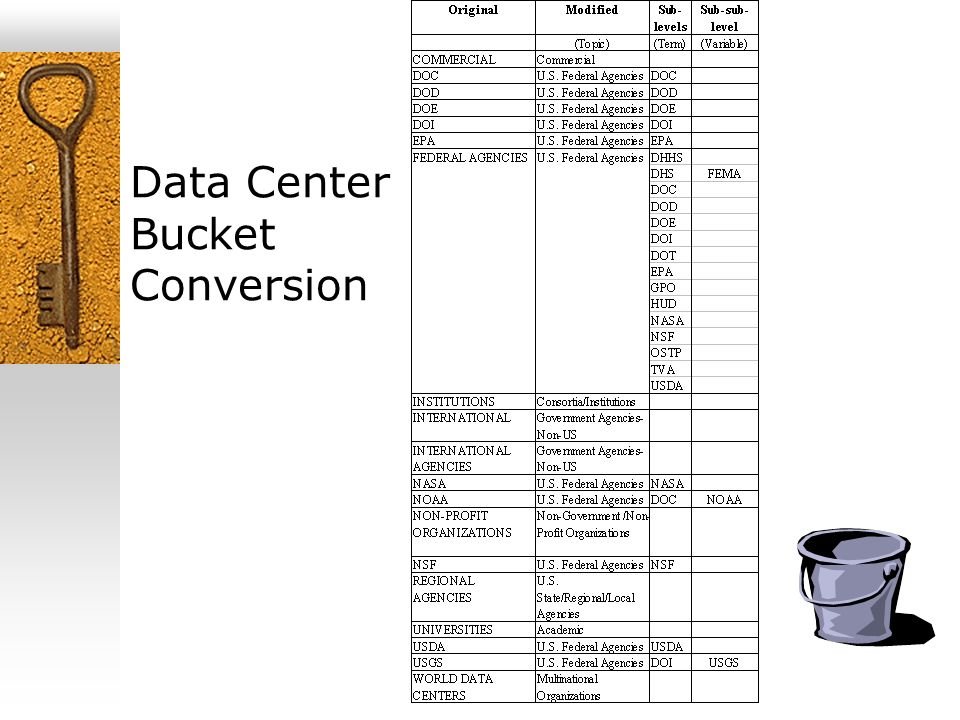
Data Center Bucket Conversion

51
Data Center Bucket Clean Up Each data center name is a hierarchy consisting of a Category (or bucket), Short Name and Long Name – Data Center Category > Data Center Short Name > Data Center Long Name Government Agencies-Non-US > JP/JAXA/ISAS > Institute for Space and Astronautical Sciences, Japan Aerospace Exploration Agency, Japan Government Agencies – Non-US – broken down by country ISO identifier
, Short Name and Long Name – Data Center Category > Data Center Short Name > Data Center Long Name Government Agencies-Non-US > JP/JAXA/ISAS > Institute for Space and Astronautical Sciences, Japan Aerospace Exploration Agency, Japan Government Agencies – Non-US – broken down by country ISO identifier")
Similar presentations
 and New Access Interfaces.>")


 RFC GIS Workshop July 2007 NOAA/NESDIS/NGDC Documentation.>")

 Joris Siermann (CIFOR) Global Forest.>")


