Download presentation
Presentation is loading. Please wait.

1
Geography Challenge #3 (10 Minutes)
1. Take out your study guide for a stamp. 2. Open your TCI (RED Books) to page 3. Use the information to complete the questions (in full sentences) on the Geography Challenge 4 handout and label the map on the back. 5. I don’t care what colors you use for Question #4. 6. You may work with a partner (someone already sitting right next to you, or by yourself) *HINT* The fastest way to finish is to answer a question and then label it on the map.
 to page Use the information to complete the questions (in full sentences) on the Geography Challenge 4 handout and label the map on the back. 5. I don’t care what colors you use for Question #4. 6. You may work with a partner (someone already sitting right next to you, or by yourself) *HINT* The fastest way to finish is to answer a question and then label it on the map.")
2
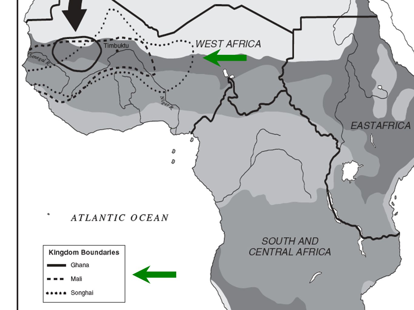
Question #1 West Africa Question 1
Which ocean borders Africa on the west? Which ocean borders Africa on the east? Which sea borders Africa on the north? Label these bodies of water. A: The Atlantic Ocean borders Africa on the west, the Indian Ocean borders Africa on the east, and the Mediterranean Sea borders Africa on the north.

4
Question #2 West Africa Question 2
Into what four regions is Africa divided? Draw in the boundaries of these regions, and label each region. A: Africa is divided into West Africa, North Africa, South and Central Africa, and East Africa.

6
Question #3 West Africa Question 3
Lightly shade each of Africa’s vegetation zones in a different color. Then fill in the key to show the meaning of each color. Which of these zones do you think people were least likely to settle? Why? A: People were least likely to settle in desert zones because it would be hard to grow food and to find water there.

8
Question #4 West Africa Question 4
Outline Ghana’s boundary in red, Mali’s boundary in blue, and Songhai’s boundary in brown. Add these colors to the key. In what region of Africa were these kingdoms located? What vegetation zones are in this part of Africa? A: These kingdoms were located in West Africa. The vegetation zones in this region include desert, semidesert.

10
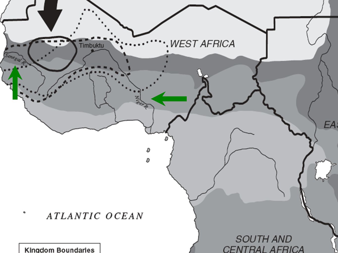
Question #5 West Africa Question 5
Label the Niger and Senegal Rivers. Why do you think these rivers were important to the societies that developed in West Africa? A: The rivers helped make the land fertile and provided fish. Also, traders traveled along the rivers.

12
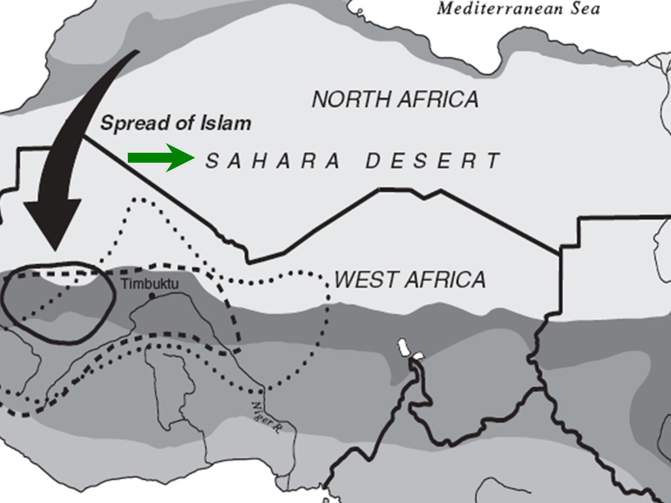
Question #6 West Africa Question 6 Label the Sahara Desert.
Why do you think the territory below the Sahara Desert might have had limited contact with lands to the north of the desert before the late 700s C.E.? A: Travel across the Sahara Desert was very difficult. (Note: Travel across the Sahara was made easier after this time because of the introduction of the camel.)
")
14
Question #7 West Africa Question 7
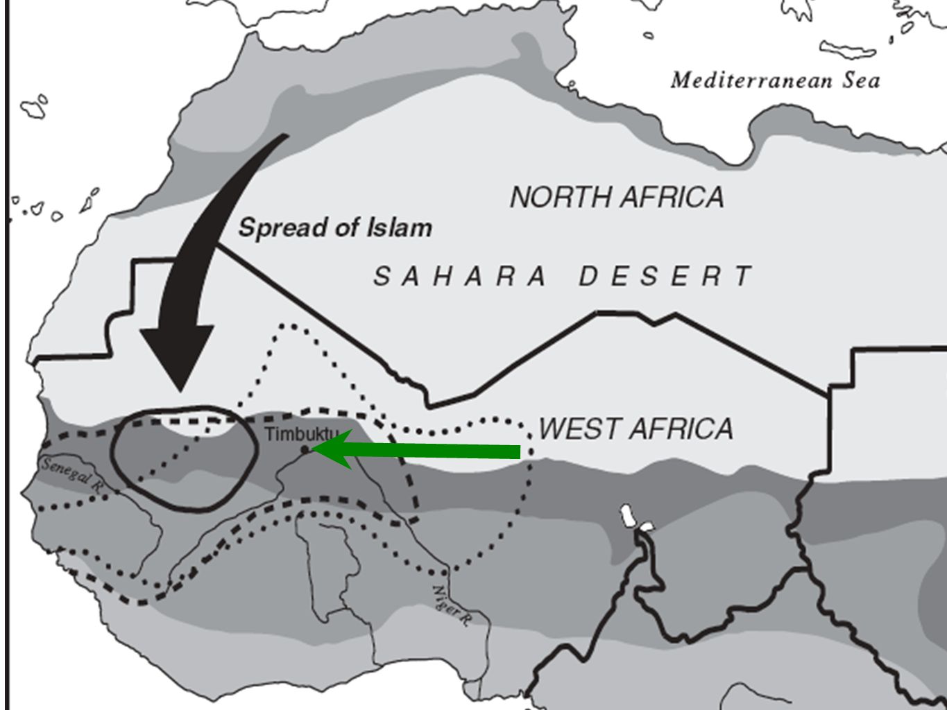
What religion spread from North Africa to West Africa? Draw and label an arrow to show the spread of this religion. A: Islam spread from North Africa to West Africa.

16
Question #8 West Africa Question 8
What city was an important center of trade and learning for the kingdoms of Mali and Songhai? Label that city. A: Timbuktu was an important center of trade and learning for the kingdoms of Mali and Songhai.

18
Correct Study Guide 1. Rifts (p. 112):
Key Terms and People 1. Rifts (p. 112): Rifts are long deep valleys formed by the movement of the earth’s crust. 2. sub-Saharan Africa (p. 112): Africa south of the Sahara Desert is known as sub-Saharan Africa.
: Rifts are long deep valleys formed by the movement of the earth’s crust. 2. sub-Saharan Africa (p. 112): Africa south of the Sahara Desert is known as sub-Saharan Africa.")
19
Correct Study Guide Key Terms and People 3. Niger River (p. 112):
A river in West Africa that served as a source of water, food, and transportation. It allowed many people to live in the area. 4. Sahara Desert (p. 114): The Sahara desert is the world’s largest desert.
: The Sahara desert is the world’s largest desert.")
20
Correct Study Guide Key Terms and People 5. Sahel (p. 114):
The Sahel is a strip of land that divides the desert from wetter areas. It is fairly dry, but has enough vegetables to support hardy grazing animals. 6. savannah (savanna)(p. 114): The savannah is open grassland with scattered trees, tall grasses, and shrubs. Grazing animals are common in the savannah
(p. 114): The savannah is open grassland with scattered trees, tall grasses, and shrubs. Grazing animals are common in the savannah.")
21
Correct Study Guide 7. rain forests (p. 114):
Key Terms and People 7. rain forests (p. 114): Rain forests are moist, densely wooded areas. Many plants and animals live in the rain forests.
: Rain forests are moist, densely wooded areas. Many plants and animals live in the rain forests.")
22
Correct Study Guide Questions 1. (Short Answer) In which African climate region would you most like to live? Why? (p. 114) Intro 2-3 Juicy Details Conclusion

23
Correct Study Guide Questions 2. List four of early West Africa’s important mineral resources and where they came from. (pgs ) Dates - Desert Oasis Kola Nuts - Forests Salt - Sahara Desert Gold - Southern Forests

24
Correct Study Guide Essential Question #1 1. Describe the physical features, vegetation, and climate of the different areas of West Africa.

25
New Standard 1. Take out your Standards page
2. Add the following standard: 7.4.2 Analyze the importance of family, labor specialization, and regional commerce to the development of states and cities in West Africa.

26
Study Guide Section 2 Work Time (15 Minutes)
Study Guide Work Time Study Guide Section 2 Work Time (15 Minutes) 1. Complete Study Guide Section 2 Key Terms and People and Questions. 2. We will review them in 15 minutes.
 1. Complete Study Guide Section 2 Key Terms and People and Questions. 2. We will review them in 15 minutes.")
27
Study Guide Section 2 Key Terms and People
Correct Study Guide Study Guide Section 2 Key Terms and People 1. Extended Family (p. 116): An extended family included the father, mother, children, and close relatives in one household. 2. animism (p. 117): Animism i the belief that boies of water, animals, trees, and other natural objects have spirits.
: An extended family included the father, mother, children, and close relatives in one household. 2. animism (p. 117): Animism i the belief that boies of water, animals, trees, and other natural objects have spirits.")
28
Study Guide Section Questions
Correct Study Guide Study Guide Section Questions 1. (Short Answer) Describe how the use of iron changed the lives of the Nok people. (p. 118)
 Describe how the use of iron changed the lives of the Nok people. (p. 118)")
29
Correct Study Guide The use of Iron changed the lives of the Nok people dramatically. One way that their lives were changed was by using iron to create farming tools, such as the hoe, which was able to clear the land more quickly and easily than earlier tools. This resulted in the Nok being able to grow more food. Iron was also used to create tips for arrows and spears which provided for better defensive and hunting weapons. Finally, the Nok were able to use the iron to make tools to cut down trees to clear land for farms. This lead to an increase in the amount of land available for housing and farming. Overall, the use of iron lead to a growth in the strength and populatin of the Nok.

30
Study Guide Section Questions
Correct Study Guide Study Guide Section Questions 2. What animal made trade across the Sahara easier? Why? (p. 119) A: The camel made trade aross the Sahara easier because they could travel long distances without as much food or water as horses. They could also carry heavier loads than horses.
 A: The camel made trade aross the Sahara easier because they could travel long distances without as much food or water as horses. They could also carry heavier loads than horses.")
31
Study Guide Section Questions
Correct Study Guide Study Guide Section Questions 3. List the main items being traded and in what directions they moved. (p. 119) Salt - From Sahara to south Gold - From south to north (Europe/Islamic World) Slaves - North and South
 Salt - From Sahara to south. Gold - From south to north (Europe/Islamic World) Slaves - North and South.")
32
Correct Study Guide You may work on:
HW Time You may work on: 1. Answering Essential Question #2 2. Two new symbols/images and two keywords-info to the cover page 3. Study for the Test

Similar presentations


>")

