Download presentation
Presentation is loading. Please wait.

1
Canada’s Landform Regions

2
Glacial Erosion

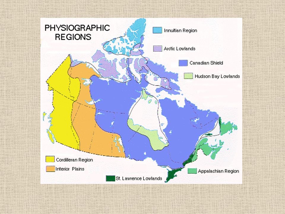
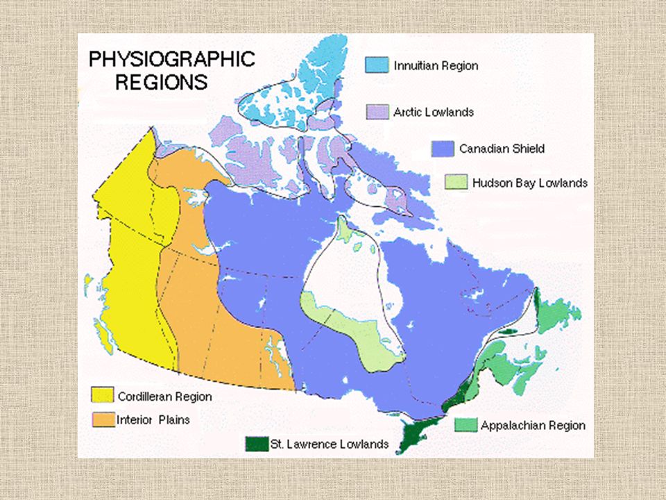
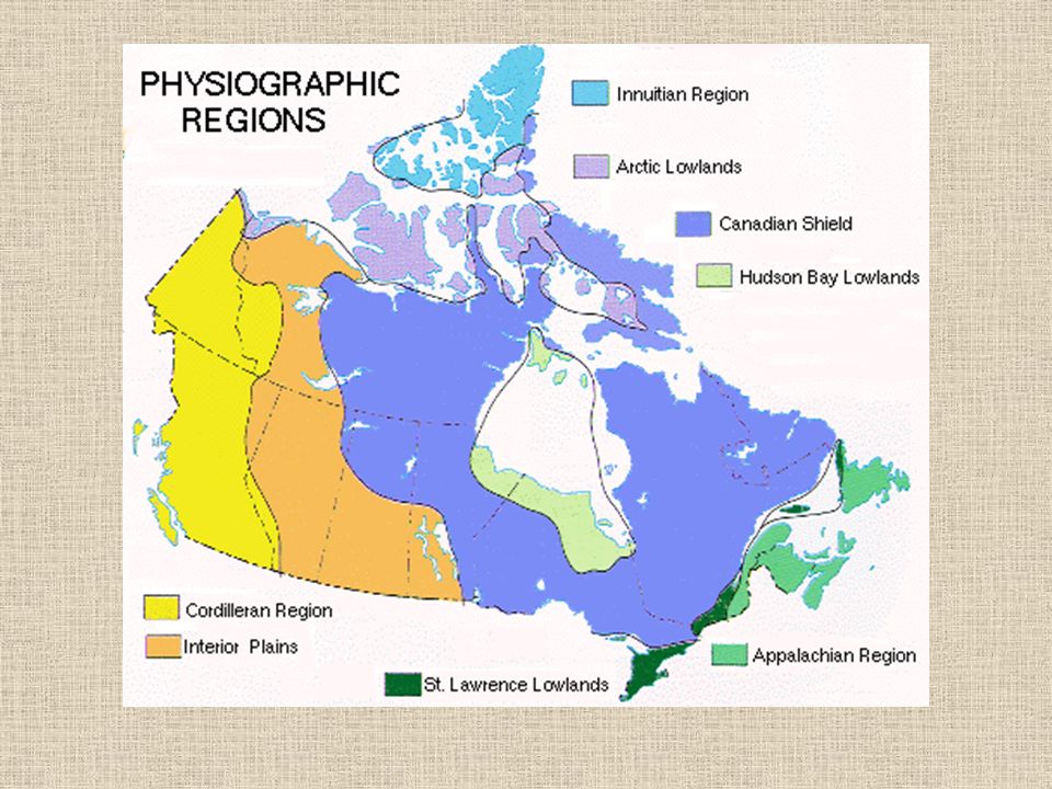
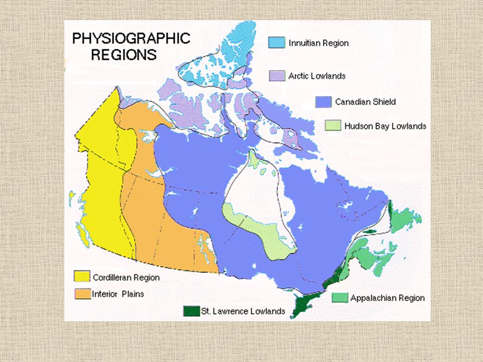
3
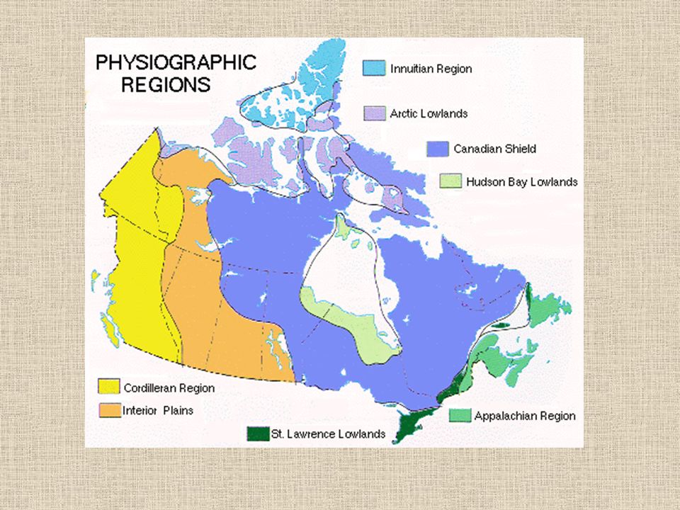
Landform Region Map

4
Canadian Shield Lake near Port Cartier, Quebec Rounded hills in the background

5
Canadian Shield Boulder field in the Northwest Territories More evidence of glaciation

6
Canadian Shield Exposed rock along the lakeshore Notice the scratches in the rock They were caused by glaciers

7
Canadian Shield A boulder in the Northwest Territories It was deposited here by a retreating glacier

8
Canadian Shield Exposed rock near Abitibi, Quebec The scratches are the result of a glacier

9
Canadian Shield Canada’s oldest and largest landform. Forms the foundation for the rest of Canada. Very thin acidic soil. Poor for agriculture. Shaped by erosion (glaciers and weather).
..")
11
Appalachian Mountains

12
Bald Mountain NB Notice the rounded mountains

13
Appalachian Mountains Aspy Bay in Cape Breton

14
Appalachian Mountains Cape Breton Highlands The mountains have been flattened by erosion Erosion: soil and rock is moved by wind or water to a different location.

15
Appalachian Mountains Atlantic Canada Rounded Mountains through erosion Rolling Hills and Valleys Fertile soil. Good for farming

17
Western Cordillera Mountains of the Yukon Notice the jagged peaks If you looks carefully, you will also see glaciers

18
Western Cordillera One of the large glaciers found in the Yukon

19
Western Cordillera A glacier-fed lake in Jasper National Park in Alberta

20
Western Cordillera Jasper National Park The valley is U- shaped because it was carved by a glacier, not the river you see here

21
Western Cordillera The Coast Mountains provide a dramatic backdrop in this picture of North Vancouver, BC

22
Western Cordillera A series of parallel mountains Are considered young as they have not been effected by erosion Valleys are good for farming as soil has been put there through sedimentation Western side has huge timber where as the eastern side has much smaller trees.

24
Innuitian Mountains The dramatic cliffs of Ellesmere Island, Nunavut

25
Innuitian Mountains A glacier and its melt water on Ellesmere Island, Nunavut

26
Innuitian Mountains Red rocks and barren landscape on Melville Island Melville Island is divided between Nunavut and the Northwest Territories

27
Innuitian Mountains Due to their “young” age they have not been worn down through erosion. Rugged Peaks Approx 2000m in height The area is too cold for trees to survive.

29
Arctic Lowlands Tundra in Nunavut Notice the flat land and strewn rocks

30
Arctic Lowlands The flat, exposed land of Prince Patrick Island in the Northwest Territories

31
Arctic Lowlands Another image of Prince Patrick Island in the NWT The flat land allows melting water to cover a vast area

32
Arctic Lowlands South of the Innuitian Mountains Is a region of tundra and is treeless. Cold, dry and poorly drained soil. Sparse vegetation

34
Interior Plains Farmland near the Red River in Southern Manitoba

35
Interior Plains The meandering Red River in Southern Manitoba

36
Interior Plains The Cypress Hills in Southern Saskatchewan

37
Interior Plains The Qu’Appelle Valley in Southern Saskatchewan A rare change from the flat landscape in this region

38
Interior Plains Cows graze in a rocky field These rocks, deposited by glaciers, are called moraine

39
Interior Plains Located between Shield and Cordillera. Created by a dried up inland sea and through erosion In some areas the soil is very deep (black soil due to carbon content) and in others it is almost desert like Extends to the Gulf of Mexico
 and in others it is almost desert like Extends to the Gulf of Mexico.")
41
Great Lakes – St. Lawrence Lowlands Typical farm in Ontario

42
Great Lakes – St. Lawrence Lowlands The city of Toronto from the air Notice the lack of hills Also notice the smog

43
Great Lakes – St. Lawrence Lowlands Farmland near Toronto

44
Great Lakes – St. Lawrence Lowlands Southern Ontario from the air Notice the flat horizon

45
Great Lakes – St. Lawrence Lowlands Located south of the shield (southern Ontario and Quebec) Good soil is a the result of flooding by the Champlain Sea that receded Experienced volcanic activity a long time ago Relatively flat.
 Good soil is a the result of flooding by the Champlain Sea that receded Experienced volcanic activity a long time ago Relatively flat..")
47
Hudson Bay Lowlands A wetland known as a muskeg in Northern Manitoba

48
Hudson Bay Lowlands The watery terrain outside Churchill, Manitoba

49
Hudson Bay Lowlands The water-filled landscape near Fort Severn, Ontario

50
Hudson Bay Lowlands A forested bog outside Gilliam, Manitoba

51
Hudson Bay Lowlands North of the shield Some places rock is 2000m thick Poor drainage and flat terrain swamp like forests.

Similar presentations