Download presentation
Presentation is loading. Please wait.

1
Environmental education with use of ICT and GIS UNEP/GRID-Warsaw Centre Experiences Monika Rusztecka, Environmental Information Centre UNEP/GRID-Warszawa

2
Each UNEP/GRID-node is much involved in education activitiesEach UNEP/GRID-node is much involved in education activities Target groups are diverseTarget groups are diverse Focus on sustainable development and environmental managementFocus on sustainable development and environmental management –Capacity building, good governance (former Soviet Rep. – Arendal, Geneva) –GIS trainings for developing countries (GRID-Sioux Falls) –Environmental education for young people and trainings for teachers (GRID-Warsaw, Geneva)
 –GIS trainings for developing countries (GRID-Sioux Falls) –Environmental education for young people and trainings for teachers (GRID-Warsaw, Geneva).")
3
Activities in UNEP/GRID-Warsaw short review Long term educational projectsLong term educational projects Training projects dedicated for teachersTraining projects dedicated for teachers Event-based educational projects for pupilsEvent-based educational projects for pupils Training programmes for public sectorTraining programmes for public sector

4
Long-term educational projects The GLOBE Programme (since 1997) –All year cooperation with teachers (over 60 schools actively involved) –Training workshops (basic and advance level, twice a year –GLOBE Games for pupils (once a year) –Teachers community – activities in the frame of GLOBE field studies and monitoring
 –All year cooperation with teachers (over 60 schools actively involved) –Training workshops (basic and advance level, twice a year –GLOBE Games for pupils (once a year) –Teachers community – activities in the frame of GLOBE field studies and monitoring")
5
Training projects for teachers in cooperation with Teachers development Centres Thematic scope: use of ICT tools and techniques in teaching of an environmental subjects (geography and biology)Thematic scope: use of ICT tools and techniques in teaching of an environmental subjects (geography and biology) 2-3 days workshops for teachers form Poland (since 2005 – at least once a year)2-3 days workshops for teachers form Poland (since 2005 – at least once a year) Strong focus on combining field work and Internet resources and tools (working with numeric map, Google Earth, Internet Databases, 3D visualizations, introduction to GIS)Strong focus on combining field work and Internet resources and tools (working with numeric map, Google Earth, Internet Databases, 3D visualizations, introduction to GIS) Use of GPS/PDA devicesUse of GPS/PDA devices
Thematic scope: use of ICT tools and techniques in teaching of an environmental subjects (geography and biology) 2-3 days workshops for teachers form Poland (since 2005 – at least once a year)2-3 days workshops for teachers form Poland (since 2005 – at least once a year) Strong focus on combining field work and Internet resources and tools (working with numeric map, Google Earth, Internet Databases, 3D visualizations, introduction to GIS)Strong focus on combining field work and Internet resources and tools (working with numeric map, Google Earth, Internet Databases, 3D visualizations, introduction to GIS) Use of GPS/PDA devicesUse of GPS/PDA devices")
6
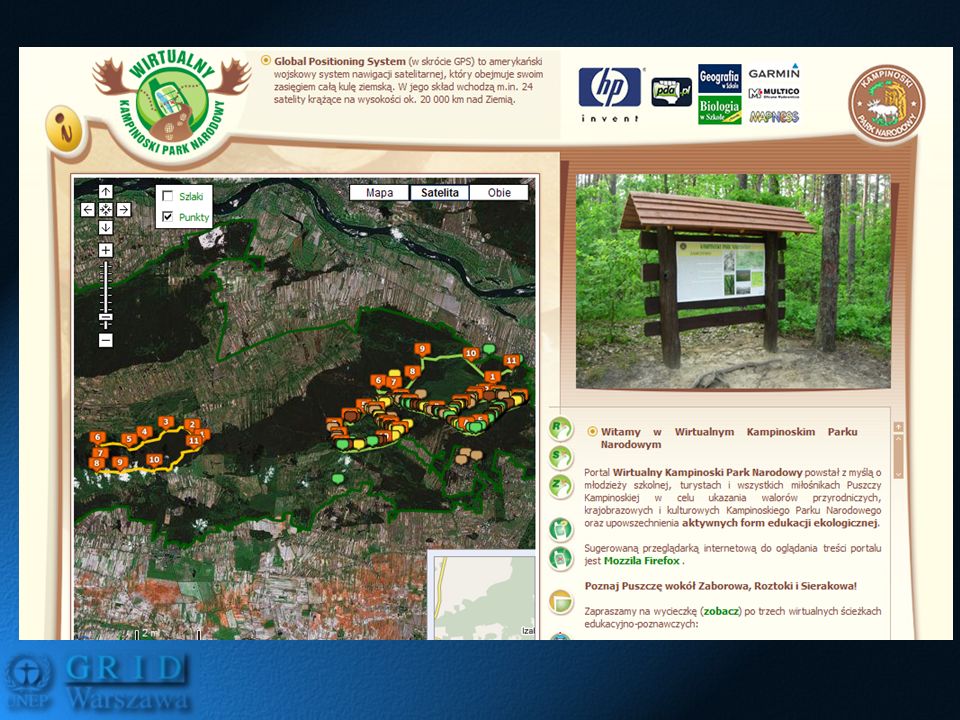
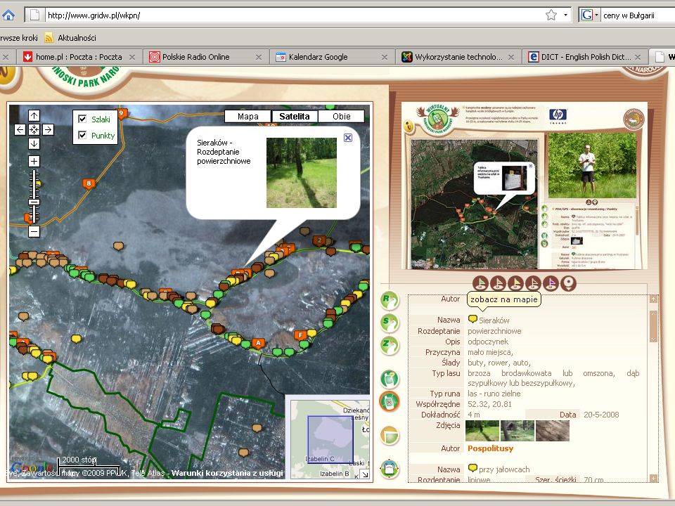
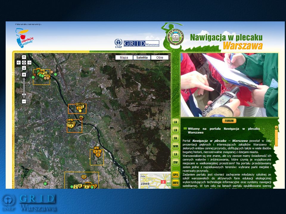
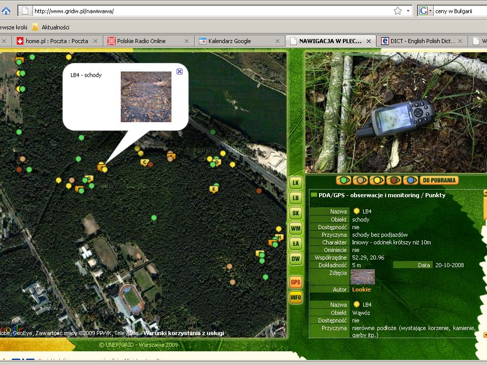
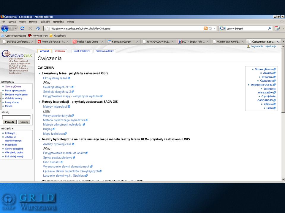
Community-based portals and event-based educational projects for pupils Virtual Kampinos National Park andVirtual Kampinos National Park and Navigation in backpack (KPN, Warsaw) Educational field-event/game for pupilsEducational field-event/game for pupils Nature observation and monitoring with use of GPS and internet-based formsNature observation and monitoring with use of GPS and internet-based forms Interactive mapping (Google Maps)Interactive mapping (Google Maps) Community, competition, fun (special tasks)Community, competition, fun (special tasks)
 Educational field-event/game for pupilsEducational field-event/game for pupils Nature observation and monitoring with use of GPS and internet-based formsNature observation and monitoring with use of GPS and internet-based forms Interactive mapping (Google Maps)Interactive mapping (Google Maps) Community, competition, fun (special tasks)Community, competition, fun (special tasks)")
7
Training for teachresTraining for teachres –1 day workshop with GPS devices and working with portal (data input to thematic forms) –Trial measurements and work in the frame of group (sharing responsibilities and tasks among pupils) –Consultations with methodologist on project approach
 –Trial measurements and work in the frame of group (sharing responsibilities and tasks among pupils) –Consultations with methodologist on project approach")
12
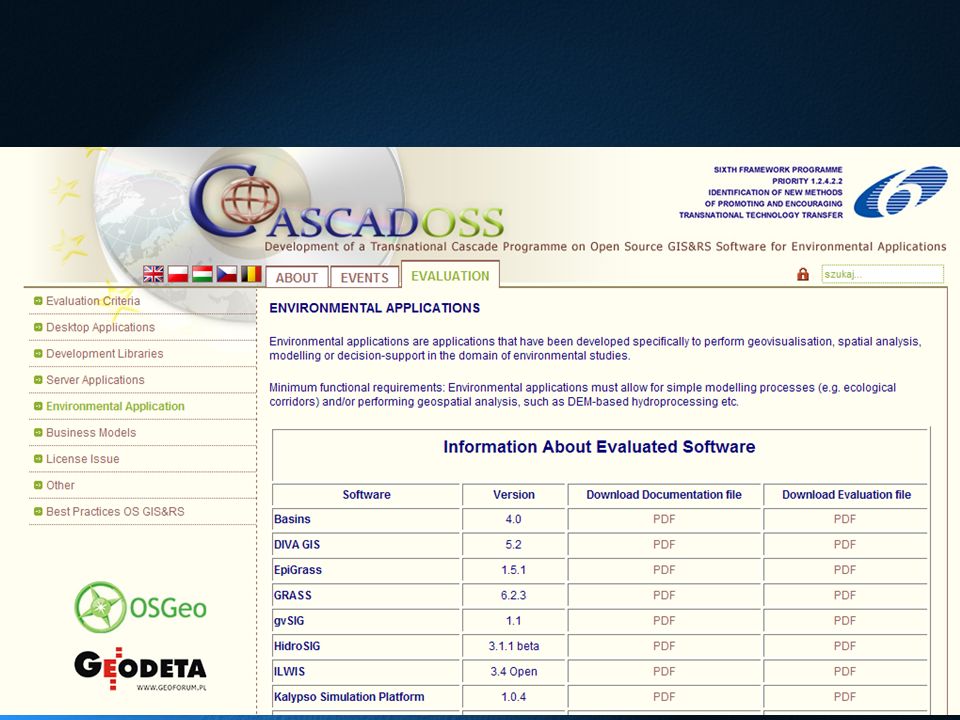
Training projects on GIS applications for public sector CASCADOSS – FOSS4G for environmental applications (2007-2009)CASCADOSS – FOSS4G for environmental applications (2007-2009) –Training workshops (2 days) for staff of National Parks and Regional Services for Environmental Conservation The INSPIRE Academy (2008-2010)The INSPIRE Academy (2008-2010) –Complex training programme for communes on use of GIS in spatial planning and environmental management (e-Learning, 2, 2-day trainings) –Increasing capacity of local administration in the use of geoinformation
CASCADOSS – FOSS4G for environmental applications ( ) –Training workshops (2 days) for staff of National Parks and Regional Services for Environmental Conservation The INSPIRE Academy ( )The INSPIRE Academy ( ) –Complex training programme for communes on use of GIS in spatial planning and environmental management (e-Learning, 2, 2-day trainings) –Increasing capacity of local administration in the use of geoinformation")
15
Core target groups Teachers (ICT and GIS in new curricula)Teachers (ICT and GIS in new curricula) –Geography –Biology Public administration staffPublic administration staff –communes (INSPIRE) –environmental management staff (nature protection services(!!!) Pupils – who are much more familiar with GPS tools, like to play with Google EarthPupils – who are much more familiar with GPS tools, like to play with Google Earth StudentsStudents
Teachers (ICT and GIS in new curricula) –Geography –Biology Public administration staffPublic administration staff –communes (INSPIRE) –environmental management staff (nature protection services(!!!) Pupils – who are much more familiar with GPS tools, like to play with Google EarthPupils – who are much more familiar with GPS tools, like to play with Google Earth StudentsStudents")
16
Level of interest in GIS/ICT trainings among target groups Teachers – very strong interest in fostering qualifications and skills in use of ICT – GIS could be one of the „edu-path”Teachers – very strong interest in fostering qualifications and skills in use of ICT – GIS could be one of the „edu-path” Public administrationPublic administration –Nature protection services - very strong interest in informal ways of learning (e-learning) – lack of free GIS courses –Communes (if it is required – they will be interested – but no „passion” about it)
 – lack of free GIS courses –Communes (if it is required – they will be interested – but no „passion about it)")
17
How to reach a target groups? Teachers – trough cooperation with Teachers development CentresTeachers – trough cooperation with Teachers development Centres –Building a community of teacher advisors who can „animate” other teachers and present how the ICT and GI can be implemented in the content of geography and biology Pupils – through a teachers (GIS oriented educational projects)Pupils – through a teachers (GIS oriented educational projects) Students – through cooperation and networking among UniversitiesStudents – through cooperation and networking among Universities
Pupils – through a teachers (GIS oriented educational projects) Students – through cooperation and networking among UniversitiesStudents – through cooperation and networking among Universities.")
18
How to reach a target groups? GI community – promo action among NGO and scientific institutes (also in reference to INSPIRE implementation)GI community – promo action among NGO and scientific institutes (also in reference to INSPIRE implementation) Public administration – INSPIRE !Public administration – INSPIRE ! –cooperation with regional offices of geodesy and cartography (recommendation for eGIS+ resources) –cooperation with environmental protection services (National parks!) through the Ministry of the Environment and related units
GI community – promo action among NGO and scientific institutes (also in reference to INSPIRE implementation) Public administration – INSPIRE !Public administration – INSPIRE . –cooperation with regional offices of geodesy and cartography (recommendation for eGIS+ resources) –cooperation with environmental protection services (National parks!) through the Ministry of the Environment and related units.")
19
ConstrainsConstrains Not sufficient knowledge of English language – need for translation of the learning materials (or cooperation with teacher of English)Not sufficient knowledge of English language – need for translation of the learning materials (or cooperation with teacher of English) E-learning as a method of learning – need for self-discipline, extra time for learning (postgraduate)E-learning as a method of learning – need for self-discipline, extra time for learning (postgraduate)
Not sufficient knowledge of English language – need for translation of the learning materials (or cooperation with teacher of English) E-learning as a method of learning – need for self-discipline, extra time for learning (postgraduate)E-learning as a method of learning – need for self-discipline, extra time for learning (postgraduate)")
20
DisseminationDissemination Promotion among teachers communityPromotion among teachers community –Cooperation with the development centers –GLOBE Programme network Education-related authorities – Ministry of Education – ICT implementation unitEducation-related authorities – Ministry of Education – ICT implementation unit

21
DisseminationDissemination Promotion among GI communityPromotion among GI community –National level – scientific units, GI discussion lists, NGOs, articles in GI magazines or promo baner (Geodeta in PL) –International level (OSGeo Foundation – Education Group, Agile, discussion lists, GI thematic portals)
 –International level (OSGeo Foundation – Education Group, Agile, discussion lists, GI thematic portals)")
22
Thanks for your attention Thanks for your attention UNEP/GRID-Warszawa Centre http://www.gridw.pl

Similar presentations