Download presentation
Presentation is loading. Please wait.

1
Multimodal Corridor Plan BCC Discussion Item Transportation Planning Division August 19, 2014

2
Presentation Outline Project Context Project Overview Project Implementation Coordination with Other Initiatives

3
Project Context Goal to have transportation better reflect land use Transportation plan historically roadway-focused 2011 legislation removed state mandates Develop and implement a different approach More urban, multimodal, safer for pedestrians/bicyclists

4
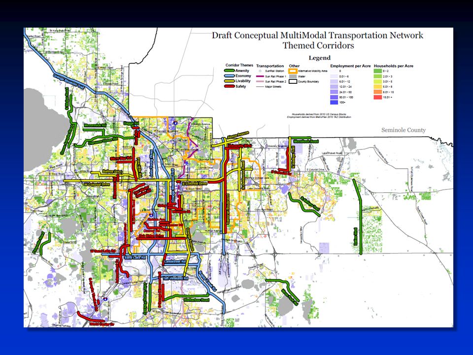
Project Context Make key State/County corridors more multimodal Year 2040 network designed to leverage limited available funding Coordinated plan to make investments add most value Flexibility to fund operational/ non-capacity projects Use maintenance/resurfacing to add multimodal features

5
Project Overview

6
ProjectOverview Project Overview Phase 1 Plan document addresses safety and planning needs Based on extensive technical analysis Analysis of County and specific corridors Understand trends and potential solutions to support balanced network

7
Project Overview Organized by Theme: – Safety – Livability – Technology – Economy – Amenity

8
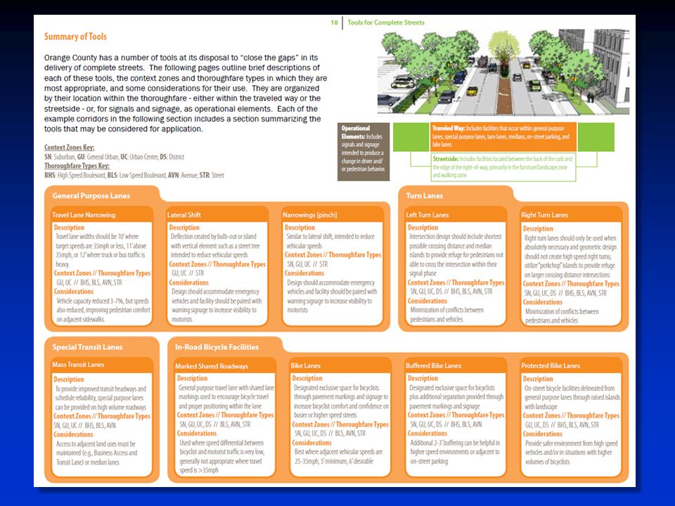
Project Overview: Safety Analysis of crash data, intersections, posted speeds Complete Streets guidelines / corridor review ADA assessment Pedestrian safety strategies

9
Project Overview: Livability Land use and placemaking Orange Avenue University Boulevard Lighting, landscaping, and streetscape “Road diet” analysis High quality transit areas

10
Project Overview: Technology Fiber optics and adaptive signals Red light safety cameras Beacons / traffic control technologies Pedestrian/bicycle data collection Multimodal trip planning for real-time travel information

11
Project Overview: Economy Potential Multimodal Focus Areas – International Drive – UCF Major employment clusters Freight mapping and analysis Revenue constraints Public-private partnerships

12
Project Overview: Amenity Recreational trails / Trails Master Plan Multiuse path network Parking – On Street – Structured parking Bikesharing / carsharing

13
Project Implementation Studies informed by Phase 1 Public Works ADA Compliance Initiative Multimodal scope for Sand Lake Road RCA Road Safety Audit – Texas-Americana New Pedestrian Safety Program Freight projects submitted to regional/ state freight plans

14
Project Implementation Phase II underway Developing multimodal 2040 network Based on MPO 2040 LRTP projects and projected funding Modeling and cost projections Refining transportation-land use performance measures

15
Project Implementation Phase III in 2016 Identify individual corridors for multimodal transition Determine funding sources/options Orange County Complete Streets Policy Develop concurrency alternatives Guidance for impact fee update

18
Coordination with Other Initiatives Orange County Sustainability Plan Forthcoming Sustainable Land Development Code – Land use context – Street standards MetroPlan Orlando’s 2040 Long Range Transportation Plan Forthcoming FDOT Complete Streets standards

19
Coordination with Other Initiatives The Sustainability Plan and the Multimodal Corridor Plan recognize that the County’s many places have unique characteristics and needs.

20
Coordination with Other Initiatives Built Environment – urban form, walkability, shared parking, context-sensitive design Community – walkable communities, traffic safety Education – walking and biking to school Natural Resources – expanded tree canopy for walkability Built Environment – code/incentives for infill and redevelopment, workforce housing near transit Community – walkable communities for better health, mix of land uses Mobility – multiple transportation options, access to transit, trail connectivity Natural Resources – strengthen and connect regional trail systems, alternative fuel vehicles Community – traffic safety, connected communities Built Environment – urban form and enhancements for pedestrian safety Mobility – multi-modal trip planning, technology for pedestrian safety Civic Engagement – increase access to jobs, transit Built Environment – economic effects of infrastructure improvements, ROI for redevelopment, TOD Mobility – fiscal sustainability, TOD to enhance transit ridership Education – sustainable schools, location to reduce need for transportation Community – create destinations with a mix of uses and amenities (to increase walkability) Arts and Culture – public art enhances places (to increase walkability), increasing access to venues (emphasis on transit), amenities at transit stops, public art along right-of-way
 Arts and Culture – public art enhances places (to increase walkability), increasing access to venues (emphasis on transit), amenities at transit stops, public art along right-of-way")
21
Multimodal Corridor Plan BCC Discussion Item Transportation Planning Division August 19, 2014

Similar presentations


 Regional Transportation Plan (RTP) Housing choices and opportunities Housing choices and.>")

