Download presentation
Presentation is loading. Please wait.

1
Land Use and Land Cover Change
Isaac Gerg

2
Land Cover & Usage Timeline History Playing Field Visible
Multispectral Hyperspectral SAR

3
2008 2004 2003 2002 2001 2000 VIIRS EnMap 2009 – TanDEM-X GeoEye-1 ARTEMIS Worldview-1 2007 – TerraSAR-X 2007 – RADARSAT-2 2006 – PALSAR Kompsat-2 FORMOSAT-2 2003 – Orbview 3 2003 – LISS-3 NEMO 2002 – MERIS ASAR 2001 – Quickbird 2001 – Orbview-4 2001 – CHRIS 2000 – Hyperion 2000 – ALI 1999 – MODIS 1999 – MISR 1999 – Landsat-7 1999 – Kompsat-1 1999 – Ikonos 1999 – ASTER 1997 – Orbview 2 1995 – RADARSAT-1 1995 – ATSR 1994 – SIR-C/X-SAR 1992 – JERS-1 1991 – AMI 1987 – Seasat 1986 – SPOT 1978 – AVHRR 1972 – Landsat 1 1990 1980 1970 1860 1870 1880 1890 1900 1910 1920 1930 1940

4
History 1858: First aerial pictures by French photographer and balloonist Nada over Paris, France. 1959: Explorer 6 takes first satellite image of earth. 1972: Birth of Landsat and birth of spaceborne MSI. 1972: Blue Marble from Apollo 17. 1977: KH-11 series satellites give first near real-time imagery. 2007: Worldview-1 has current lowest commercial 0.5m for a satellite.

5
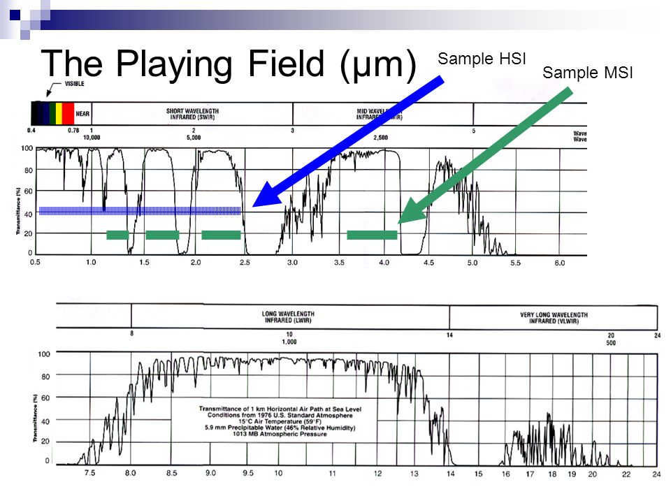
The Playing Field (μm) Sample HSI Sample MSI
6
Synopsis of Imagery Sensors
Visible (Spaceborne) Iknonos, Quickbird, Explorer 6 (1959), KH (197), WorldView-1 Multispectral (Spaceborne) Landsat, MODIS, ALI, MISR, SPOT (86 – 2002, 5 satellites) Hyperspectral (Satellite) Hyperion TacSat-3 SAR (Spaceborne) SIR-C/X-SAR (1994), SRTM(2000), TerraSAR X TODO (insert more of these here) Hyperspectral (Airborne) AVIRIS (1994), HyDICE (210 bands nm), ARCHER HYperspectral Digital Imagery Collection Experiment
 Iknonos, Quickbird, Explorer 6 (1959), KH (197), WorldView-1. Multispectral (Spaceborne) Landsat, MODIS, ALI, MISR, SPOT (86 – 2002, 5 satellites) Hyperspectral (Satellite) Hyperion. TacSat-3. SAR (Spaceborne) SIR-C/X-SAR (1994), SRTM(2000), TerraSAR X. TODO (insert more of these here) Hyperspectral (Airborne) AVIRIS (1994), HyDICE (210 bands nm), ARCHER. HYperspectral Digital Imagery Collection Experiment.")
7
Visible Wavelength Sensors
Launch Date GSD [m] Country Orbview 2,3 1997, 2003 USA Kompsat-1 1999 6 Korea Ikonos 1 Quickbird 2001 0.6 FORMOSAT-2 2004 2 Taiwan Kompsat-2 2006 Worldview-1 2007 0.5 GeoEye-1 (Orbview-5) 2008 0.41
")
8
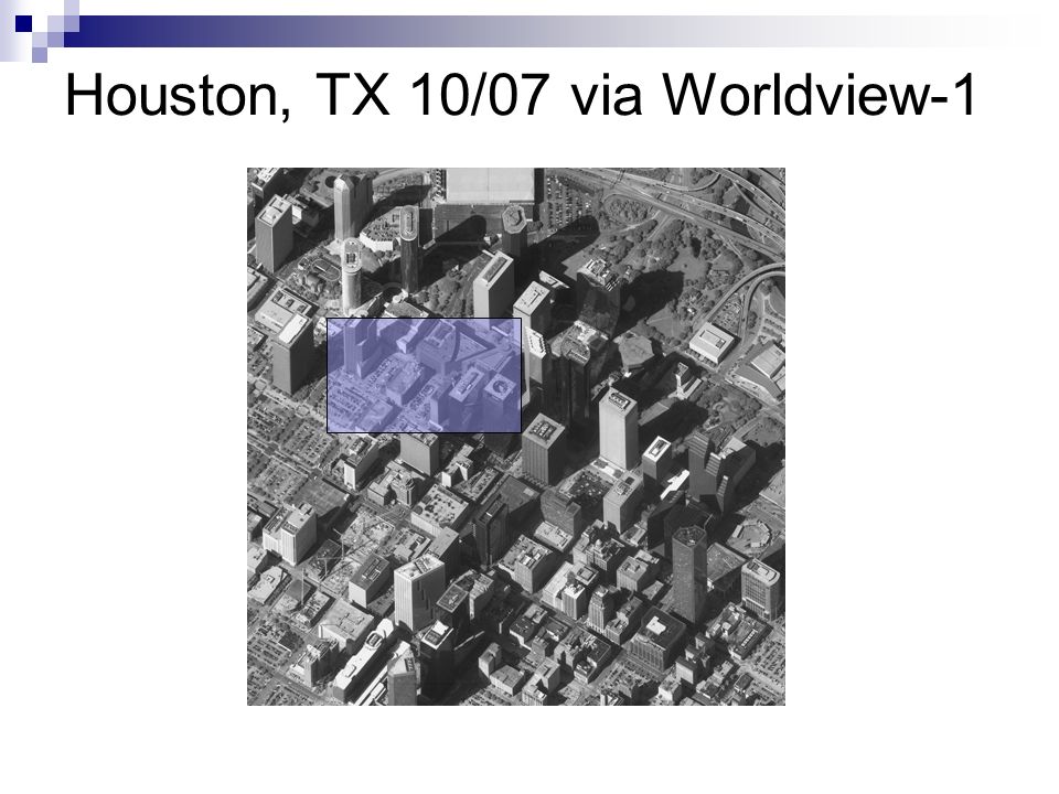
Houston, TX 10/07 via Worldview-1
9
Houston, TX 10/07 via Worldview-1

10
Visible Light Sensors Ikonos (1999): 1m resolution
Quickbird (2001): 60cm resolution Worldview-1 (2007): 50 cm resolution GeoEye-1 (aka OrbView-5) (2008): 41cm resolution. Orbview 2, 3 (2997, 2003) 3 is now out of commission FORMOSAT-2 (2004) (Twain) 2m resolution. Kompsat-1 (1999) Korea 6m resolution. Kompsat-2 (2006) Korea 1m resolution
: 60cm resolution. Worldview-1 (2007): 50 cm resolution. GeoEye-1 (aka OrbView-5) (2008): 41cm resolution. Orbview 2, 3 (2997, 2003) 3 is now out of commission. FORMOSAT-2 (2004) (Twain) 2m resolution. Kompsat-1 (1999) Korea 6m resolution. Kompsat-2 (2006) Korea 1m resolution.")
11
Utility of MSI NDVI Crop growth stage Fire detection
Surface Temperature Landcover usage (NLCD) Deforestation monitoring Mineral mapping Soil Brightness Index (SBI) Green Vegetation Index (GVI)
 Deforestation monitoring. Mineral mapping. Soil Brightness Index (SBI) Green Vegetation Index (GVI)")
12
Multispectral Sensors
Platform Launch Date Country MSS, ETM+ Landsat 1-7 USA AVHRR NOAA POS SPOT France ATSR ERS-2 1995 ESA MODIS Terra, Aqua 1999, 2002 ASTER Terra 1999 MISR (multi-angle look) ALI EO-1 2000 MERIS Envisat 2002 LISS-3,4 ResourceSat-1 2003 India VIIRS NPOESS 2013
 ALI. EO MERIS. Envisat LISS-3,4. ResourceSat India. VIIRS. NPOESS")
13
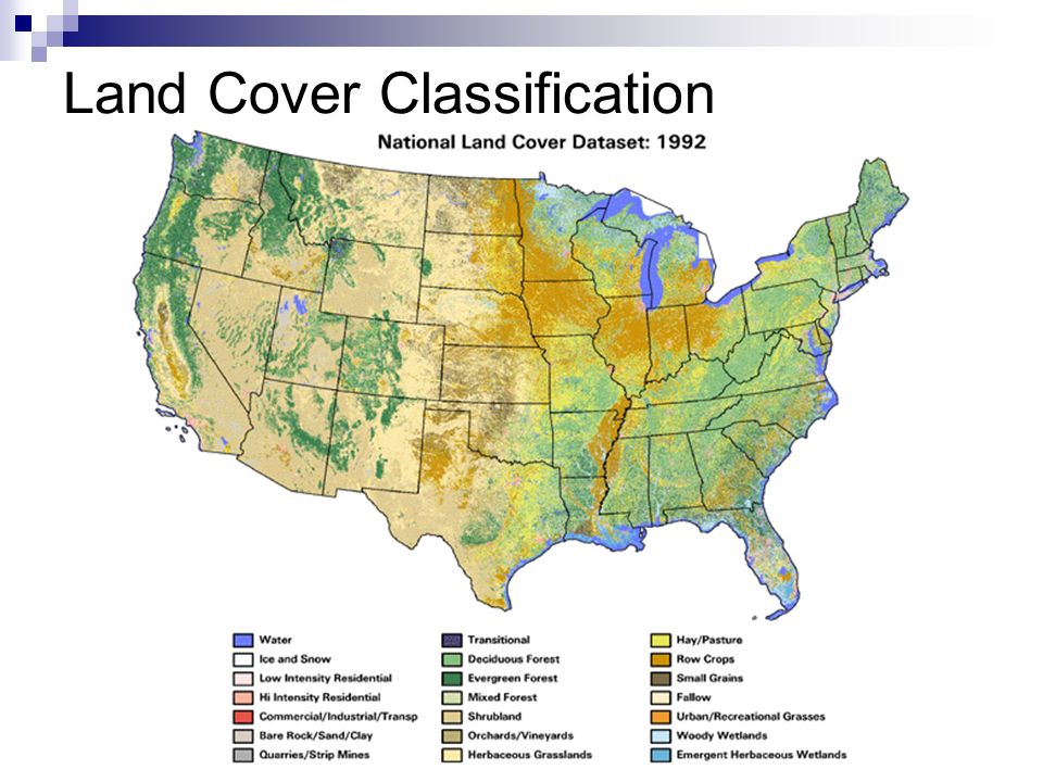
Land Cover Classification
14
MODIS Fire Map

15
MODIS NDVI

16
Multispectral Sensors
Landsat ( ) MODIS (1999, 2002) aboard Terra and Aqua satellites. ALI (2000) aboard EO-1 MISR (1999) aboard Terra, multi-angle look imagery. SPOT ( ) France. ASTER (1999) aboard Terra MERIS (2002) aboard Envisat. ATSR (1995) aboard ERS-2 AVHRR ( ) aboard NOAA POS. VIIRS (2013) aboard NPOESS LISS-3/4 (2003) aboard IRS-P6 (aka ResourceSat-1, India).
 MODIS (1999, 2002) aboard Terra and Aqua satellites. ALI (2000) aboard EO-1. MISR (1999) aboard Terra, multi-angle look imagery. SPOT ( ) France. ASTER (1999) aboard Terra. MERIS (2002) aboard Envisat. ATSR (1995) aboard ERS-2. AVHRR ( ) aboard NOAA POS. VIIRS (2013) aboard NPOESS. LISS-3/4 (2003) aboard IRS-P6 (aka ResourceSat-1, India).")
17
Landsat Program Sats launched 1972-1999
7 satellites (Landsat 6 failed to reach orbit) Only 5 and 7 still functioning Multispectral (MSS) on Landsat 1-5 Thematic Mapper (TM) sensor on Landsat 4 & 5 0.45 um – 2.35um + thermal band ( ) Enhanced Thematic Mapper (ETM+) on Landsat 7 Landsat 1: 18 day revisit, RBV, MSS Landsat 2: 18 day revisit, RBV, MSS Landsat 3: 18 day revisit, RBV, MSS, first with thermal band Landsat 4: 16 day revisit, TM, MSS, 30m max resolution Landsat 5: TM, MSS, 16 day revisit, provide global archive of satellite photos, TM Landsat 7 (ETM+, 16 day revisit, 15m resolution panchromatic, 60m thermal resolution, Current, cloud free imagery) ETM+ has 8 bands including thermal Multispectral Scanner (MSS)
 Only 5 and 7 still functioning. Multispectral (MSS) on Landsat 1-5. Thematic Mapper (TM) sensor on Landsat 4 & um – 2.35um + thermal band ( ) Enhanced Thematic Mapper (ETM+) on Landsat 7. Landsat 1: 18 day revisit, RBV, MSS. Landsat 2: 18 day revisit, RBV, MSS. Landsat 3: 18 day revisit, RBV, MSS, first with thermal band. Landsat 4: 16 day revisit, TM, MSS, 30m max resolution. Landsat 5: TM, MSS, 16 day revisit, provide global archive of satellite photos, TM. Landsat 7 (ETM+, 16 day revisit, 15m resolution panchromatic, 60m thermal resolution, Current, cloud free imagery) ETM+ has 8 bands including thermal. Multispectral Scanner (MSS)")
18
Utility of HSI Material abundance maps (MAMs) Subpixel detection
Automatic target recognition (ATR) Crop health Crop type
![]()
19
Hyperspectral Sensors
Platform Launch Date Country Hyperion (220 bands) EO-1 2000 USA CHRIS PROBA-1 2001 ESA Orbview-4 2001 (DNO) ARIES Australia NEMO Cancelled 2002 ARTEMIS (~400 bands) TacSat-3 2008 EnMap 2011 Germany DNO – did no orbit
 EO USA. CHRIS. PROBA ESA. Orbview (DNO) ARIES. Australia. NEMO. Cancelled ARTEMIS (~400 bands) TacSat EnMap Germany. DNO – did no orbit.")
20
Mineral Maps of Cuprite, NV

21
MAM from Moffett Field, CA

22
Hyperspectral Sensors
Hyperion (2000) aboard EO-1 220 bands ARTEMIS (2008) aboard TacSat-3 ~400 bands EnMap (2011) Germany ARIES (Australian) NEMO (NRL) Cancelled 2002 Orbview-4 (2001) failed to orbit. CHRIS (2001) aboard PROBA-1 (ESA) CHRIS:
 aboard EO bands. ARTEMIS (2008) aboard TacSat-3. ~400 bands. EnMap (2011) Germany. ARIES (Australian) NEMO (NRL) Cancelled Orbview-4 (2001) failed to orbit. CHRIS (2001) aboard PROBA-1 (ESA) CHRIS:")
23
Utility of SAR Polarization All weather DEM Urban density
Soil moisture Crop type

24
SAR Sensors Seasat 1987 USA AMI ERS-1,2 1991, 1995 ESA JERS-1
Platform Launch Date Country Seasat 1987 USA AMI ERS-1,2 1991, 1995 ESA JERS-1 Japan SIR-C/X-SAR Endeavor 1994 RADARSAT-1,2 1995, 2007 Canada ASAR Envisat 2002 PALSAR ALOS 2006 TerraSAR-X 2007 Germany TanDEM-X 2009

25
SIR-C/X-SAR SAR Examples

26
Questions?

27
References See slide notes.

28
SAR Sensors Seasat (1987) First spaceborne SAR - NASA
SIR-C/X-SAR (1994) aboard shuttle JERS-1 (1992) Japan (returned to earth in 1998) RADARSAT-1,2 (1995, 2007) Canada ASAR (2002) aboard Envisat (ESA) AMI (1991,95) aboard ERS-1/2. PALSAR (2006) aboard ALOS (JAEA) TerraSAR-X (2007) German TanDEM-X (2009) Germany (DEM)
 aboard shuttle. JERS-1 (1992) Japan (returned to earth in 1998) RADARSAT-1,2 (1995, 2007) Canada. ASAR (2002) aboard Envisat (ESA) AMI (1991,95) aboard ERS-1/2. PALSAR (2006) aboard ALOS (JAEA) TerraSAR-X (2007) German. TanDEM-X (2009) Germany (DEM)")
29
ERS European remote sensing satellite ERS-1: 1991, ERS-2: 1995 Ers-1
Radar altimiter, Radiometer, SAR, Wind scatterometer, MWR (microwave radiometer) ERS-2 GOME (Global Ozone Monitoring Experiment) Added Radiometer bands for vegatation / chlorphyll analysis. Sucessor is ENVISAT
 ERS-2. GOME (Global Ozone Monitoring Experiment) Added Radiometer bands for vegatation / chlorphyll analysis. Sucessor is ENVISAT.")
30
ENVISAT 35 day revisit Launched 2002
ASAR, MERIS (MEdium Resolution Imaging Spectrometer), AATSR (Advanced Along Track Scanning Radiometer), RA-2 (Radar Altimeter 2), MWR, DORIS (Doppler Orbitography and Radiopositioning Integrated by Satellite, Used for accurate orbit position 10cm), GOMOS (Global Ozone Monitoring by Occultation of Stars), MIPAS (Michelson Interferometer for Passive Atmospheric Sounding), SCIAMACHY (SCanning Imaging Absorption spectroMeter for Atmospheric CHartographY) ASAR = Advance SAR
, AATSR (Advanced Along Track Scanning Radiometer), RA-2 (Radar Altimeter 2), MWR, DORIS (Doppler Orbitography and Radiopositioning Integrated by Satellite, Used for accurate orbit position 10cm), GOMOS (Global Ozone Monitoring by Occultation of Stars), MIPAS (Michelson Interferometer for Passive Atmospheric Sounding), SCIAMACHY (SCanning Imaging Absorption spectroMeter for Atmospheric CHartographY) ASAR = Advance SAR.")
31
Airborne Photography First = French photographer and balloonist Nadar in 1858 over Paris, France Airborne Real-time Cueing Hyperspectral Enhanced Reconnaissance (ARCHER)
")
32
MODIS MODIS (Moderate-resolution Imaging Spectroradiometer)
1999, 2002 (Terra and Aqua) 36 bands (0.4 µm to 14.4 µm)
 36 bands (0.4 µm to 14.4 µm)")
33
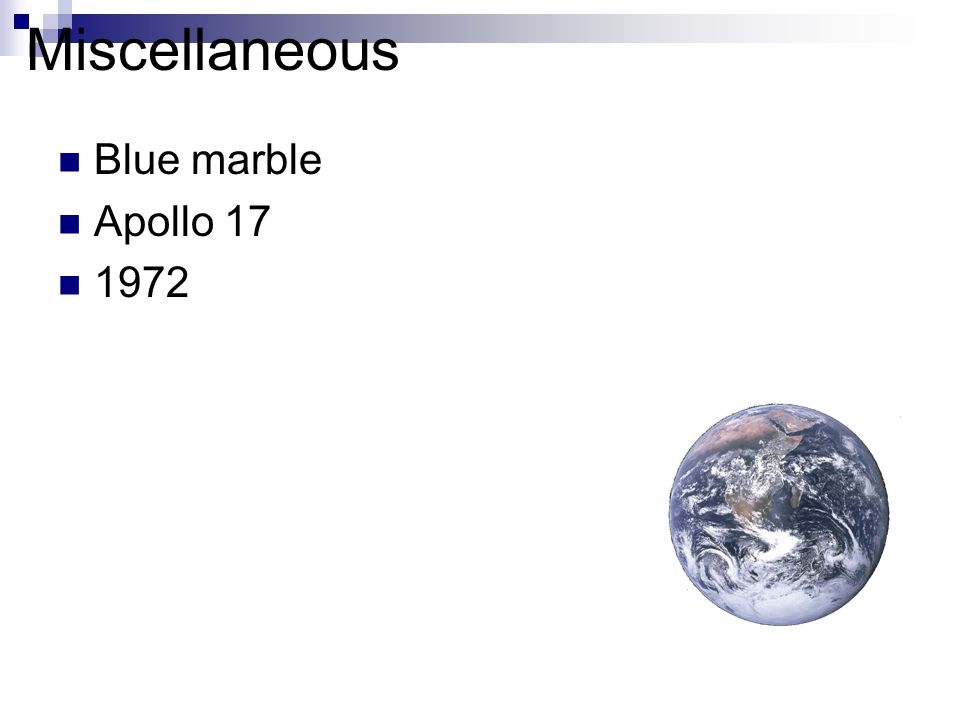
Miscellaneous Blue marble Apollo 17 1972
34
Commercial Imagery Today
Ikonos (2000) GeoEye 0.8m-4m resolution, MS and PAN, 144 day revisit for true nadir 3-5 day revist for off-nadir Orbview-2,3 (1997, 2003 respectively) Orbview 2 has NASAS SeaWiFS stands for Sea-viewing Wide Field-of-view Sensor. Quickbird (2001) 60sm resolution PAN and MS
 GeoEye. 0.8m-4m resolution, MS and PAN, 144 day revisit for true nadir. 3-5 day revist for off-nadir. Orbview-2,3 (1997, 2003 respectively) Orbview 2 has NASAS SeaWiFS stands for Sea-viewing Wide Field-of-view Sensor. Quickbird (2001) 60sm resolution. PAN and MS.")
35
EO Sats MODIS Hyperion ALI
36 bands covering 0.4 µm to 14.4 µm Hyperion 220 bands ALI 8 bands MISR (Multi-angle Imaging SpectroRadiometer) (1999, NASA) 9 cameras (multiangle) ASTER 15 bands MSS, Stereo
 (1999, NASA) 9 cameras (multiangle) ASTER. 15 bands MSS, Stereo.")
Similar presentations


, infrared (BW, Color) –RADAR (SLAR, SAR) –LIDAR (light detection and ranging)>")


 and Landsat Thematic Mapper (TM) Sensor System Characteristics.>")


-Polar Orbiting Environmental Satellite (POES) Orbital characteristics.>")

