Download presentation
Presentation is loading. Please wait.

1
Ozone Layers Aloft Bill Brick & Bill Reeve San Diego County APCD SCOS97-NARSTO DATA ANALYSIS CONFERENCE FEBRUARY 15, 2001

2
SCOS97-NARSTO LOGO

3
3-D OZONE PLOT: ARB Art Collins

4
3-D OZONE PLOT: ARB Art Collins

5
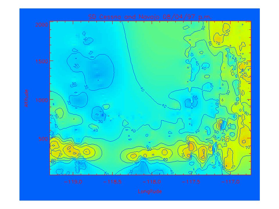
August 4-7, 1997 August 4 (Mon): Weak South Coast Air Basin ozone maximum August 5 (Tue): Weak SCAB ozone maximum; weak upper level transport to San Diego August 6 (Wed): Weak SCAB ozone maximum; secondary South Coast Air Basin ozone maximum with transport into Mojave Desert; eddy transport to Ventura following episode in the SCAB
: Weak South Coast Air Basin ozone maximum August 5 (Tue): Weak SCAB ozone maximum; weak upper level transport to San Diego August 6 (Wed): Weak SCAB ozone maximum; secondary South Coast Air Basin ozone maximum with transport into Mojave Desert; eddy transport to Ventura following episode in the SCAB")
38
August 22-23, 1997 August 22 (Fri): Weak secondary SCAB ozone maximum with transport into Mojave August 23 (Sat): Weak secondary SCAB ozone maximum with transport into Mojave
: Weak secondary SCAB ozone maximum with transport into Mojave August 23 (Sat): Weak secondary SCAB ozone maximum with transport into Mojave")
42
September 4-6, 1997 September 4 (Thu): Upper level transport to San Diego September 5 (Fri): Weak secondary SCAB ozone maximum with transport into Mojave September 6 (Sat): Eddy transport to Ventura following episode in the SCAB
: Upper level transport to San Diego September 5 (Fri): Weak secondary SCAB ozone maximum with transport into Mojave September 6 (Sat): Eddy transport to Ventura following episode in the SCAB")
50
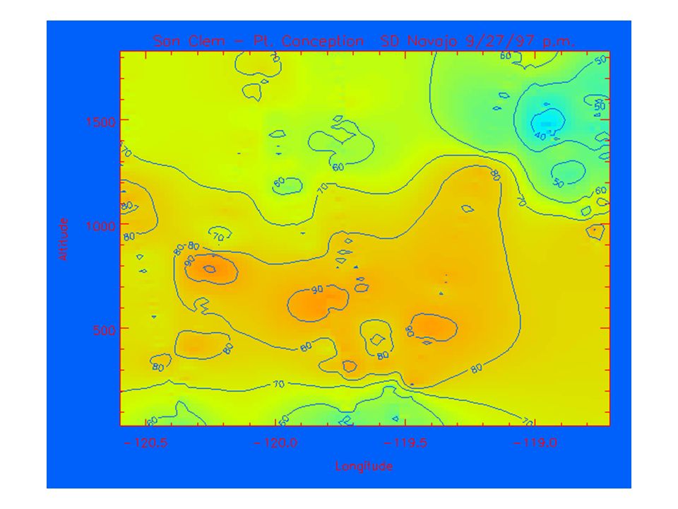
September 27-29, 1997 September 27 (Sat): Weak upper level transport to San Diego; weak secondary SCAB ozone maximum with transport into Mojave September 28 (Sun): Weak upper level transport to San Diego; weak secondary SCAB ozone maximum with transport into Mojave September 29 (Mon): Eddy transport to Ventura following episode in the SCAB
: Weak upper level transport to San Diego; weak secondary SCAB ozone maximum with transport into Mojave September 28 (Sun): Weak upper level transport to San Diego; weak secondary SCAB ozone maximum with transport into Mojave September 29 (Mon): Eddy transport to Ventura following episode in the SCAB")
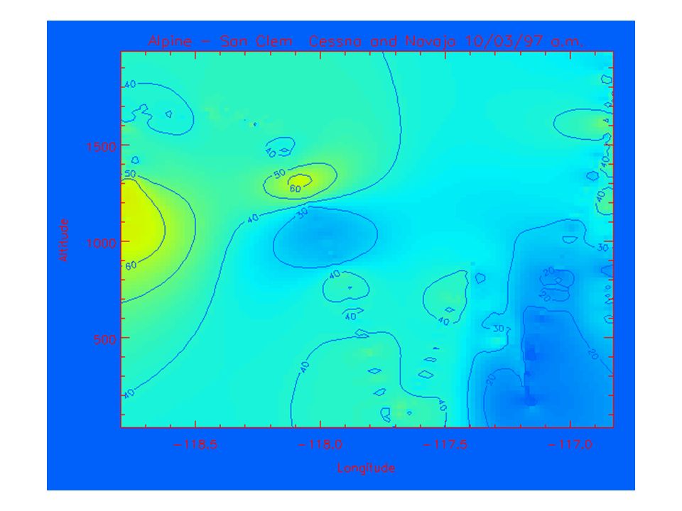
64
October 3-4, 1997 October 3 (Fri): No episode October 4 (Sat): Weak secondary SCAB ozone maximum with transport into Mojave Desert; eddy transport to Ventura following episode in the SCAB
: No episode October 4 (Sat): Weak secondary SCAB ozone maximum with transport into Mojave Desert; eddy transport to Ventura following episode in the SCAB")
69
Summary Measurements show ozone layers aloft. Ozone layers are persistent and wide- spread over the SCOS97 domain. Transported ozone layers have potential to impact downwind areas at surface.

70
Future Steps: Want to identify source region and fate of ozone layers aloft. Expand current analysis and include additional platforms (UCD Cessna, US Navy aircraft, ozonesondes, lidar, surface monitoring sites). Trajectory analysis using profiler and modeled wind fields. Investigation of HC and NO y data collected by aircraft.
. Trajectory analysis using profiler and modeled wind fields. Investigation of HC and NO y data collected by aircraft..")
71
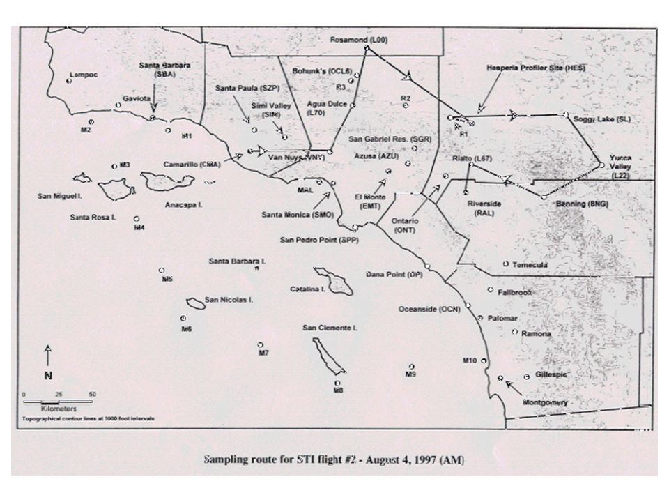
Acknowledgements: Jerry Anderson, et al. (STI) for Navajo and Cessna data processing ARB for project coordination, data archive (CD-ROM); Leon Dolislager for timely supply of supplemental aircraft data SCAQMD and ARB for arranging and hosting this Conference
 for Navajo and Cessna data processing ARB for project coordination, data archive (CD-ROM); Leon Dolislager for timely supply of supplemental aircraft data SCAQMD and ARB for arranging and hosting this Conference.")
Similar presentations


 Robert A. Baxter, CCM T&B Systems Clark County Air Quality Forum – 03/14/06.>")

;>")


 Robert A. Baxter, CCM T & B Systems,>")

School Calendar>")


