Download presentation
Presentation is loading. Please wait.

1
Estimating Pedestrian and Bicycle Miles Traveled (PMT/BMT) in Washington State Krista Nordback, P.E., Ph.D. Mike Sellinger, MURP Taylor Phillips

2
Overview Purpose & Scope Review Data Methods Results Conclusions & Recommendations Next Steps

3
PURPOSE

4
Motivation VMT is an accepted metric for motorized travel. A comparable metric is needed for walking and cycling. Needed by – Policy makers – Engineers – Planners – Researchers

5
Why measure walking & biking? Funding & policy decisions To show change over time Facility design Planning (short-term, long-term, regional…) Economic impact Public health Safety
 Economic impact Public health Safety.")
6
Motivation SAFETY: Accurate estimation of bicyclist and pedestrian volumes are critical to evidence- based safety analysis of bicycling and walking. HEALTH: Exposure to air pollutants Changes in physical activity

7
BMT and PMT Bicycle Miles Traveled (BMT) Pedestrian Miles Traveled (PMT)
 Pedestrian Miles Traveled (PMT)")
8
REVIEW

9
TRAFFIC MONITORING PROGRAMS

10
State Traffic Monitoring Metro Count Accessed 6/13/13 http://mtehelp.tech-metrocount.com/article.aspx?key=mc5805 Commonly inductive loops Permanent Counters Short Duration Counters Commonly pneumatic tubes

11
Permanent Counters

12
Short Duration Counters

13
AADT and VMT

14
Can we apply these methods to biking and walking?

15
Permanent Counters in 2012 Bicycle Counter

16
Permanent Counters now? Bicycle Counter Bicycle and Pedestrian Counter

17
Short Duration Counts

18
DATA

19
Non-motorized Data TypeProsCons Survey/travel dairyRepresentative sampleNo facility level info GPSRoute choice includedUsually self-selection bias Continuous and short- term counts Facility levelMany locations needed Volume Data: Spatial Variables: Facility type, land use, geography Socio-demographics, population

20
METHODS Estimating Pedestrian and Bicycle Miles Traveled (PMT/BMT) in Washington State
 in Washington State")
21
Pedestrian/Bicycle Volume Estimates Sample based approach Aggregate demand model Travel Surveys

22
Continuou s Counts Seasonal Adjustment Factors AADB/AADP X Manual Counts Road Segment Length Count-Based BMT/PMT = Aggregate Demand Model = Aggregate Demand BMT/PMT

23
Count-based Method Stratified Random Sample – Where to count? – Which strata (attributes) impact bike/ped volumes?
 impact bike/ped volumes .")
24
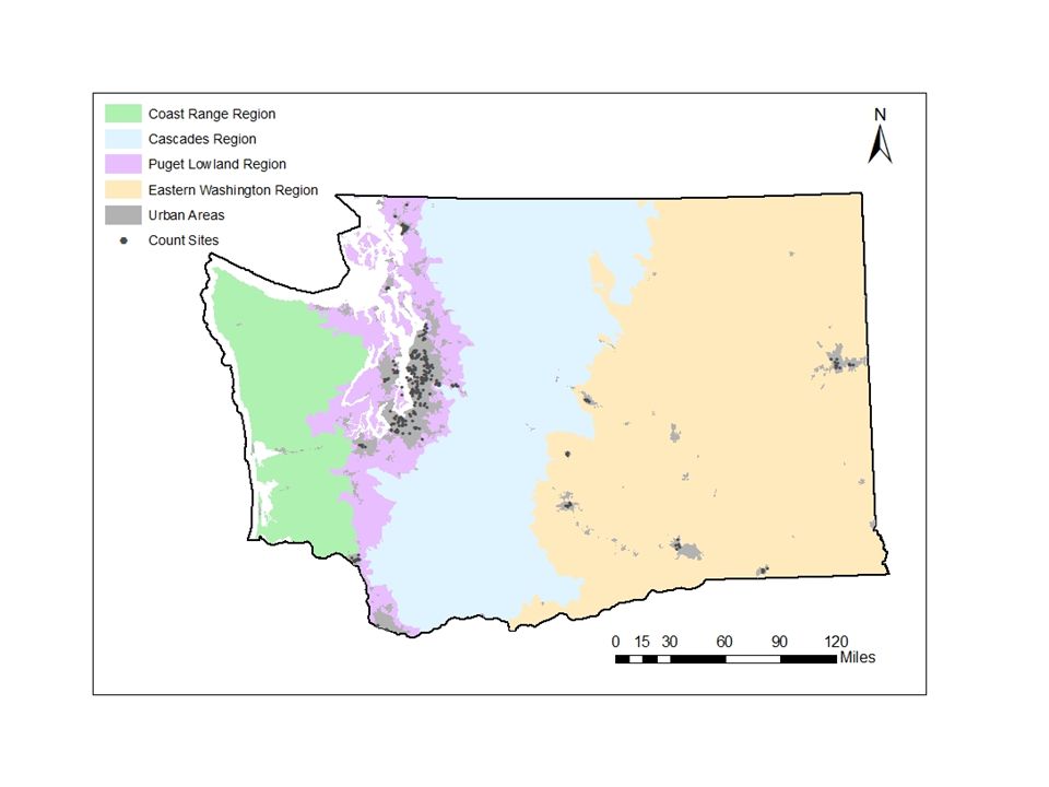
Sampling Groups AttributeRecommended CategoriesNumber of Categories Level of urbanismUrban Rural 2 Road or path typeArterials & highway, Local Roads, Collectors, & Paths 2 Geographic and climatic regions Coast Range Puget Lowland Cascades Eastern Washington 4

25
Urban vs. Rural

26
Arterial/Highway vs. Local/Collector/Path

27
WSDOT EcoRegions

29
Count-based Method Groups 4 Regions X 2 Urban/Rural X 2 Road Type= 16 Groups Compute center lane miles for each Compute Average Annual Daily Bicycle and Pedestrians (AADBP) for each. Compute PMT or BMT = Miles X AADBP X 365 days/year

30
Traffic Patterns Seattle – one year of data Olympia – multiple sites with 7 days of data

31
Fremont Bridge, Seattle Annual Average Daily Bicyclists (AADB) = 2,461
 = 2,461")
32
Fremont Bridge, Seattle

33
Annual Average Daily Bicyclists (AADB) = 2,461
 = 2,461")
34
Factoring Method Adapted from Traffic Monitoring Guide AADB = C known * M * D C known = hourly count M = Monthly Factor D = Daily/Hourly Factor

35
Monthly Factor M = AADB MADB where MADB = Ave daily bike count in that month December =2,000 1,000 = 2 Daily counts in December are half of AADB.

36
Created Monthly Factors Month Monthly AADBFactor January1,4481.7 February1,7871.4 March2,1321.2 April2,4001.0 May3,5020.7 June3,2370.8 July3,8060.6 August3,3730.7 September2,6910.9 October2,2541.1 November1,6881.5 December1,1732.1

37
Created Daily/Hourly Factors 7-8 AM Week- day 8-9 AM Week- day 10-11 AM Week- day 11- Noon Week- day 4-5 PM Week- day 5-6 PM Week- day 6-7 PM Week- day Noon-1 PM Satur- day 1-2 PM Satur- day January9.06.126.532.311.05.58.128.321.0 February8.86.028.433.411.25.47.817.116.3 March9.97.129.439.313.26.38.613.912.5 April8.26.225.731.410.05.36.726.933.1 May8.76.729.941.012.15.67.521.417.5 June9.37.127.834.811.45.77.316.214.4 July10.37.525.733.912.06.27.919.218.0 August9.86.824.633.411.75.77.122.119.8 September8.75.823.731.610.84.96.227.624.5 October14.515.217.417.014.415.322.025.122.8 November8.15.824.031.09.45.58.417.019.9 December8.65.624.233.610.15.38.324.725.1

38
Continuou s Counts Seasonal Adjustment Factors AADB/AADP X Manual Counts Road Segment Length Count-Based BMT/PMT = Aggregate Demand Model = Aggregate Demand BMT/PMT

39
Aggregate Demand Model Uses the AADB and AADP estimations calculated from manual and automated count data. Each AADB and AADP estimation was then associated with the following variables: – Facility type: This variable has three categories. Local and collector roads Arterial roads and highways Trail – Bridge: This is a dummy variable which indicates if the bicyclist or pedestrian is crossing a bridge. – Population density: Density of population in the census tract – Percent of the population aged 18 to 54 – Percent of the population with a four year degree or more

40
Aggregate Demand (cont.) These models can then be used to calculate BMT and PMT at the statewide level using the following procedure: – Associate road and trail segments throughout the state with the corresponding census tract and American Community Survey (ACS) data. – Apply the explanatory variables to each segment to estimate AADB and AADP for the segment. – Multiply AADB and AADP by the length of the segment. – Sum all of the segments throughout the state. – Multiply by 365 to get estimates for annual PMT and BMT.

41
National Household Survey Method “Back of the envelope” method Uses research from Pucher et al. NHTS and Census Data Puget Sound Regional Travel Survey

42
RESULTS

43
Available Data in 16 Groups Sampling GroupsNumber of Continuous Stations Available Stations Available in State’s Count Program RegionLevel of urbanismRoad/Path Type Coast RangeRuralArterial/Highway00 RuralLocal/Collector/Path00 UrbanArterial/Highway00 UrbanLocal/Collector/Path00 Puget Lowland RuralArterial/Highway01 RuralLocal/Collector/Path00 UrbanArterial/Highway1157 UrbanLocal/Collector/Path199 CascadesRuralArterial/Highway00 RuralLocal/Collector/Path00 UrbanArterial/Highway00 UrbanLocal/Collector/Path00 Eastern Washington RuralArterial/Highway00 RuralLocal/Collector/Path00 UrbanArterial/Highway037 UrbanLocal/Collector/Path06 Total 304 Note: There are 13 count sites for which the location is ambiguous or unknown.

44
Count-based Estimates Using the available data, annual PMT and BMT were estimated for four of the sixteen groups. Bicycle and pedestrian traffic on trails was significantly higher, on average, than on local streets. Trail site count data was removed from the local street sampling groups. Estimates are biased toward over estimation, since count sites were deliberately chosen at locations where bicycle and pedestrian activity tend to be high. This bias can be corrected in the future by randomly sampling count locations. Estimates Using Count-Based Method (Millions of Miles)
.")
45
Aggregate Demand Estimates Aggregate Model for Bicycle and Pedestrian Models

46
NHTS Estimates 415 households surveyed in Washington State 891 individuals in the 2009 NHTS 96 (11%) reported making at least one bike trip in the past week 645 individuals (72%) reported making at least one walking trip in the past week Only 2 and 9 individuals biked and walked to work in the past week, respectively Necessary to use nationwide data in order to produce an acceptable sample size of bicyclists and walkers. Statewide Estimates Using National Survey Method (in Millions of Miles) YearPMT (95% CI)*BMT (95% CI)* 2010710 (680 to 740)150 (140 to 170) 2013730 (700 to 770)160 (150 to 180) * The confidence interval (CI) only accounts for error from the National Household Travel Survey as reported by Pucher et al. 2011 (Pucher, Buehler et al. 2011). Actual error is much higher.Pucher, Buehler et al. 2011
 YearPMT (95% CI)*BMT (95% CI)* (680 to 740)150 (140 to 170) (700 to 770)160 (150 to 180) * The confidence interval (CI) only accounts for error from the National Household Travel Survey as reported by Pucher et al (Pucher, Buehler et al. 2011). Actual error is much higher.Pucher, Buehler et al")
47
King County Comparison Annual PMT and BMT for King County within the Puget Lowlands (Millions of Miles)
")
48
Comparison of Studies PMT/Person/Day Survey Method Count Method

49
CONCLUSIONS & RECOMMENDATIONS

50
Conclusions ApproachProsCons Recommended Data Improvements State-wide survey Expanding existing dataset is easier than creating new dataset. Data are not at the facility level. Fund an oversampling of the next NHTS. Count-based Data are at the facility level. - Data tend to be biased towards high count locations. - It is harder to sample pedestrian locations. Expand count program to allow for a statewide representative sample. Aggregate Demand Method More accurate estimate of PMT and BMT. Difficult to do at the state level. Expand count program to allow for a statewide representative sample.

51
Recommendations for Counting Program In coming years: – Expand program to include rural areas and mountain regions – Install at least 1 permanent counter in each of the 16 groups In the coming decades: – At least 7 permanent counters per group. – Ideally count 7 days per location – At least 150 short duration count sites per group

52
Discussion & Questions Krista Nordback, P.E., Ph.D.Mike Sellinger nordback@pdx.edunordback@pdx.edu mikesellinger@altaplanning.commikesellinger@altaplanning.com 503-725-2897 Taylor Phillips tphill2@pdx.edu Transportation Research and Education Consortium

53
Why measure walking & biking?

54
Conclusions Existing count data are not sufficient for BMT/PMT estimation More data needed Random sampling needed to get better representation Combining with GPS data potential For bikes – count based approach OK For peds – aggregate approach more appropriate

55
Adventure Cycling Adventure Cycling Route Mileage Estimates

56
Ride with GPS & Strava Data Number of GPS Uploaded Trips Across Years 2005 48 2006 54 2007 58 2008 438 2009 1,001 2010 2,878 2011 6,285 2012 12,885 2013 21,888 2014 7,451 Total 52,986 Strava Global Heat Map Ride with GPS Data

57
Organized Group Rides Name Start Location Distances Number of riders Miles Ridden Seattle to PortlandSeattle20310,0002,030,000 Chilly Hilly Bainbridge Island 343,005102,170 Flying Wheels Summer Century*Redmond401,57062,800 1001,570157,000 Totals3,139219,800 Bike MS*Mt. VernonDay 11,800 2234737 59341,977 78342,613 97343,250 Day 21,000 5050025,000 7550037,500 Totals1,80071,076 RSVPSeattle1871,400261,800 RSVP 2Seattle1871,365255,255 Cycle the WAVEBellevue121341,608 252255,625 4230012,600 6222513,950 Totals88433,783 Kitsap Color Classic*Kitsap244049,696 5740423,028 Totals80832,724 Seattle Bike-n-Brews*Seattle253919,775 5039119,550 Totals78229,325 ObliterideSeattle252245,600 5024012,000 10015915,900 1806912,420 Totals69245,920 Grand Totals23,8753,081,853 *For rides where total riders were not given for each distance, ridership was distributed evenly between mileage options

58
Miles of Road/Trails RegionLevel of UrbanismRoad/Path TypeTotal Miles Coast Range Urban Arterial409 Collector739 Trail6 Rural Arterial128 Collector13,062 Trail69 Puget Lowlands Urban Arterial4,042 Collector20,730 Trail344 Rural Arterial183 Collector15,380 Trail163 Eastern Washington Urban Arterial2,574 Collector7,140 Trail108 Rural Arterial1,448 Collector54,407 Trail376 Cascades Urban Arterial219 Collector352 Trail4 Rural Arterial576 Collector33,526 Trail124 Total Centerline Miles in Washington State156,109

59
Safe Routes to School

60
Count Data State’s Count Program Olympia bike counts Seattle bike counts

61
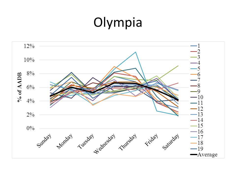
Olympia TimeMark tube counters 7 day counts Three times per year (March, June, October) YearNumber of Locations 20089 200917 201017 201117 201219
 YearNumber of Locations")
62
Seattle Manual Counts 50 locations 4 times per year – 10:00 AM to noon Weekdays – 5:00 PM to 7:00 PM Weekdays – Noon to 2:00 PM Saturdays State’s only permanent counter: Fremont Bridge New permanent counter on the Spokane St. Bridge

63
Seattle

64
Olympia

66
SUBURBAN CLASSIFICATION

67
Literature U.S. Dept of Agriculture – Rural-Urban Commuting Area Codes Ramsey & Bell (2014) – Smart Location Database Guiliano & Small (1991) – Subcenters
 – Smart Location Database Guiliano & Small (1991) – Subcenters.")
68
Washington State Densities Not enough population density to warrant suburban vs urban distinction

69
Trails

70
Past work Phase 1 – Recommendations to Improve State’s Count Program – Identify Data Sources – Identify Methods – Recommend Changes Phase 2 – Methods for Estimating Bicycling and Walking – Prepare existing count data – Outline a method to use count data to compute BMT/PMT

Similar presentations


 Briefing on the Draft Update of the Bicycle and Pedestrian Plan for the National Capital Region Michael Farrell DTP Presentation to the.>")


 – Transportation equity act.>")
>")


