Download presentation
Presentation is loading. Please wait.

1
World Regional Geography January 20, 2010
Reading: Marston Chapter 1 Website:

2
Haiti Brief History of Haiti Brief Geography of Haiti
Human / Social Physical January 12th Earthquake What happened…. Social implications International response How are geographers helping? How does this affect the world?

3
Haiti: Location

4
Colonial History 1492: Columbus lands on Hispaniola, Spanish colonize Island shortly thereafter. 1697: Eastern 1/3 of Hispaniola ceded to France by Spain (Saint-Domingue). 1791: Slave revolts begin. 1804: Haiti achieves independence. Wealthy colonial holding (sugar, coffee, indigo) – due in large part to slave labor.
. 1791: Slave revolts begin. 1804: Haiti achieves independence. Wealthy colonial holding (sugar, coffee, indigo) – due in large part to slave labor.")
5
History 1825: After several failed attempts to retake the country, France officially recognizes Haiti. 1914: British, German, and US forces enter Haiti to ‘protect their citizens”. : US occupation of Haiti. 1937: Parsley Massacre. US occupation – developed infrastructure – dismantled constitutional system – left country in shaky position US took disputed land from D.R. – when US left DR massacred Haitians living near border.

6
History 1991: Elected leader Jean-Bertrand Aristide fleas the country following a successful coup. 1994: Aristide returns with international support. 2004: Following his re-election in 2000, Aristide is again overthrown amidst corruption charges. US Marines “evacuate” Aristide. 2006: Current President Rene Preval elected.

7
Instability & Emigration
Since achieving independence in 1804 the sitting Haitian government has been overthrown 32 times. As a result hundreds of thousands have fled Haiti Dominican Republic (800,000) United States (600,000) New York City Miami (Little Haiti) Canada (100,000) Montreal France (80,000) Bahamas (80,000) Coups – military factions, members of the elite economic class, foreign nationals with economic interests, foreign governments.
 United States (600,000) New York City. Miami (Little Haiti) Canada (100,000) Montreal. France (80,000) Bahamas (80,000) Coups – military factions, members of the elite economic class, foreign nationals with economic interests, foreign governments.")
8
Haiti: Interesting Facts
Only nation in the world born of a slave revolt. First independent nation in Latin America. First black-led post-colonial independent nation in the world. Only French-speaking independent nation in the Americas. Strong connection to Louisiana Creole population. 17th century haven for pirates. Tortuga and the “Brethren of the Coast”

9
Haiti Capital: Port-Au-Prince

10
The People Population: 9,035,536 Ethnicity Religion*
African Decent: 95% White / Mulatto: 5% Religion* Roman Catholic: 80% Protestant: 16% None: 1% Other: 3% Official Languages French Creole * It is estimated that roughly 50% of the population actually practices Haitian Vodou, which merges Catholicism and West African religions.

11
Population Characteristics
Demographic differences related to stages of development. “Demographic Transition”

12
Population Density

13
Social/Vital Characteristics
Highest fertility rate in the western hemisphere. Ranks 149th out of 182 countries in U.N. Human Development Index.

14
Economic Characteristics
* Nearly 2/3 of the population is not formally employed. Haiti is the poorest country in the Western Hemisphere.

15
Socio- Economic Characteristics
Poverty Most Haitians live on less than $2 per day. 80% of the population lives below the poverty line. 54% live in “abject poverty”. Poverty has forced some 225,000 children into virtually slavery (unpaid servants). Labor Force Lack of skilled labor, and opportunities for skilled laborers. 2/3 of population relies on small-scale agriculture (subsistence), which is extremely vulnerable to natural hazards. Education Brain-drain: 80% of Haitian college graduates have left the country to find work. Inequality 50% of the nations wealth is owned by 1% of the population.
. Labor Force. Lack of skilled labor, and opportunities for skilled laborers. 2/3 of population relies on small-scale agriculture (subsistence), which is extremely vulnerable to natural hazards. Education. Brain-drain: 80% of Haitian college graduates have left the country to find work. Inequality. 50% of the nations wealth is owned by 1% of the population.")
16
Physical Geography Haiti is situated on the western part of Hispaniola, the second largest island in the Greater Antilles. Haiti is the third largest country in the Caribbean behind Cuba and the Dominican Republic (the latter shares a 360 kilometer (224 mi) border with Haiti). Haiti at its closest point is only about 45 nautical miles (80 km; 50 mi) away from Cuba and has the second longest coastline (1,771 km/1,100 mi) in the Greater Antilles, Cuba having the longest. Haiti's terrain consists mainly of rugged mountains interspersed with small coastal plains and river valleys. The northern region consists of the Massif du Nord (Northern Massif) and the Plaine du Nord (Northern Plain). The Massif du Nord is an extension of the Cordillera Central in the Dominican Republic. It begins at Haiti's eastern border, north of the Guayamouc River, and extends to the northwest through the northern peninsula. The lowlands of the Plaine du Nord lie along the northern border with the Dominican Republic, between the Massif du Nord and the North Atlantic Ocean. The central region consists of two plains and two sets of mountain ranges. The Plateau Central (Central Plateau) extends along both sides of the Guayamouc River, south of the Massif du Nord. It runs from the southeast to the northwest. To the southwest of the Plateau Central are the Montagnes Noires, whose most northwestern part merges with the Massif du Nord. Its westernmost point is known as Cap Carcasse. The southern region consists of the Plaine du Cul-de-Sac (the southeast) and the mountainous southern peninsula (also known as the Tiburon Peninsula). The Plaine du Cul-de-Sac is a natural depression which harbors the country's saline lakes, such as Trou Caïman and Haiti's largest lake, Lac Azuei. The Chaîne de la Selle mountain range – an extension of the southern mountain chain of the Dominican Republic (the Sierra de Baoruco) – extends from the Massif de la Selle in the east to the Massif de la Hotte in the west. This mountain range harbors Pic la Selle, the highest point in Haiti at 2,680 metres (8,793 ft) * Map of Haiti. The country's most important valley in terms of crops is the Plaine de l'Artibonite, which is oriented south of the Montagnes Noires. This region supports the country's (also Hispaniola's) longest river, the Riviere l'Artibonite which begins in the western region of the Dominican Republic and continues most of its length through central Haiti and onward where it empties into the Golfe de la Gonâve. The eastern and central region of the island is a large elevated plateau. Haiti also includes various offshore islands. The historically famous island of Tortuga (Île de la Tortue) is located off the coast of northern Haiti. The arrondissement of La Gonâve is located on the island of the same name, in the Golfe de la Gonâve. Gonâve Island is moderately populated by rural villagers. Île à Vache (Cow Island), a lush island with many beautiful sights, is located off the tip of southwestern Haiti. Also part of Haiti are the Cayemites and Île d' Anacaona.
 border with Haiti). Haiti at its closest point is only about 45 nautical miles (80 km; 50 mi) away from Cuba and has the second longest coastline (1,771 km/1,100 mi) in the Greater Antilles, Cuba having the longest. Haiti s terrain consists mainly of rugged mountains interspersed with small coastal plains and river valleys. The northern region consists of the Massif du Nord (Northern Massif) and the Plaine du Nord (Northern Plain). The Massif du Nord is an extension of the Cordillera Central in the Dominican Republic. It begins at Haiti s eastern border, north of the Guayamouc River, and extends to the northwest through the northern peninsula. The lowlands of the Plaine du Nord lie along the northern border with the Dominican Republic, between the Massif du Nord and the North Atlantic Ocean. The central region consists of two plains and two sets of mountain ranges. The Plateau Central (Central Plateau) extends along both sides of the Guayamouc River, south of the Massif du Nord. It runs from the southeast to the northwest. To the southwest of the Plateau Central are the Montagnes Noires, whose most northwestern part merges with the Massif du Nord. Its westernmost point is known as Cap Carcasse. The southern region consists of the Plaine du Cul-de-Sac (the southeast) and the mountainous southern peninsula (also known as the Tiburon Peninsula). The Plaine du Cul-de-Sac is a natural depression which harbors the country s saline lakes, such as Trou Caïman and Haiti s largest lake, Lac Azuei. The Chaîne de la Selle mountain range – an extension of the southern mountain chain of the Dominican Republic (the Sierra de Baoruco) – extends from the Massif de la Selle in the east to the Massif de la Hotte in the west. This mountain range harbors Pic la Selle, the highest point in Haiti at 2,680 metres (8,793 ft) * Map of Haiti. The country s most important valley in terms of crops is the Plaine de l Artibonite, which is oriented south of the Montagnes Noires. This region supports the country s (also Hispaniola s) longest river, the Riviere l Artibonite which begins in the western region of the Dominican Republic and continues most of its length through central Haiti and onward where it empties into the Golfe de la Gonâve. The eastern and central region of the island is a large elevated plateau. Haiti also includes various offshore islands. The historically famous island of Tortuga (Île de la Tortue) is located off the coast of northern Haiti. The arrondissement of La Gonâve is located on the island of the same name, in the Golfe de la Gonâve. Gonâve Island is moderately populated by rural villagers. Île à Vache (Cow Island), a lush island with many beautiful sights, is located off the tip of southwestern Haiti. Also part of Haiti are the Cayemites and Île d Anacaona.")
17
Physical Geography Area: 27,750 km², slightly smaller than Maryland.
»3rd largest Caribbean nation. Climate: Tropical, semi-arid immediately east of mountains. Terrain: Mountainous with dispersed plains and river valleys. »Highest point: 2,680 meters (8,793 feet) Arable Land: 28.11% Permanent Crops: 11.53% Define Arable Land and Permanent Crops
 Arable Land: 28.11% Permanent Crops: 11.53% Define Arable Land and Permanent Crops.")
18
Land Use

19
Physical Geography Environmental Issues Natural Hazards
Extensive Deforestation Agriculture Logging Fuel (Charcoal) Soil Erosion Mud-slides Lack of Potable Water Left side of satellite image is Haiti – right side is D.R. Define Potable Water Natural Hazards “Lies in the middle of the hurricane belt and subject to severe storms from June to October; occasional flooding and earthquakes; periodic droughts.” (CIA World Fact Book)
 Soil Erosion. Mud-slides. Lack of Potable Water. Left side of satellite image is Haiti – right side is D.R. Define Potable Water. Natural Hazards. Lies in the middle of the hurricane belt and subject to severe storms from June to October; occasional flooding and earthquakes; periodic droughts. (CIA World Fact Book)")
20
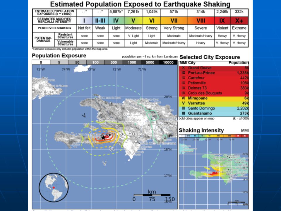
January 12, 2010 in Review Time: 4:53pm local time (Eastern Time Zone)
Magnitude: 7.0 on the Richter Scale Location: 25km (15mi) WSW of Port-Au-Prince Depth: 13km (8.1mi)
 WSW of Port-Au-Prince. Depth: 13km (8.1mi)")
21
January 12, 2010 in Review

23
Caribbean Earthquakes
How prevalent are earthquakes in this region? Was what happened rare?

24
Caribbean Earthquakes

25
Caribbean Earthquakes

26
Caribbean Earthquakes
How prevalent are earthquakes in this region? Was what happened rare? Small earthquakes occur daily in this region, although this particular earthquake was unusually large. Yes…..and no. Seismic activity is common in the Caribbean, but the precise location of this quake was somewhat unusual. The last significant earthquake along the Enriquillo-Plaintain Garden Fault occurred in 1860.

27
January 12, 2010 in Review An earthquake of this magnitude occurs somewhere in the world, on average, once every 3 weeks. In relation to other earthquakes, the Haiti quake was very strong. However, what made this earthquake particularly devastating was not necessarily its strength, but WHERE it occurred.

28
Recipe for Disaster Proximity to Population
Metro Port-Au-Prince: 2,000,000 Shallow epicenter = greater surface intensity Most buildings not designed to withstand earthquakes. Simple concrete structures. Many of the slums surrounding Port-Au-Prince are built on steep hillsides. Haiti does not have the resources to respond to a disaster of this magnitude.

29
Social Ramifications Health & Humanitarian Social & Political
Estimated 200,000 dead. 3 million Haitians in need of food, water, and medical care (U.N.). Estimated 1.5 million Haitians are now homeless. Search and rescue (5-7 days) Medical care for those successfully extracted. Sanitation and disease. Social & Political Most government infrastructure destroyed. Rule of law? “Mob Justice” Looting and rioting – both “criminal” and survival oriented. International aid - should foreign governments step in for the Haitian government?
. Estimated 1.5 million Haitians are now homeless. Search and rescue (5-7 days) Medical care for those successfully extracted. Sanitation and disease. Social & Political. Most government infrastructure destroyed. Rule of law Mob Justice Looting and rioting – both criminal and survival oriented. International aid - should foreign governments step in for the Haitian government")
30
How are Geographers Involved
Logistics Satellite Imagery: search and rescue mapping. Transportation of aid once it reaches Hispaniola. Socio-political Aid organization – making difficult decisions. Predicting social behaviors / reactions.

31
How does this affect the world?
Safety of foreign nationals. Diplomats, foreign companies Instability affects neighboring countries. Refugees / Legal length of stay. World commodity prices. Sugar, coffee Transportation and trade. Airline routes International shipping

32
Aftershock: January 20, 2010 Time: 6:03am local time (Eastern Time Zone) Magnitude: 6.1 on the Richter Scale Location: 53km (35mi) WSW of Port-Au-Prince Depth: 9.9km (6.1mi)
 WSW of Port-Au-Prince. Depth: 9.9km (6.1mi)")
Similar presentations


>")


