Download presentation
Presentation is loading. Please wait.

1
Eric Green, GISP, MSCE, PE

2
Safe, Accountable, Flexible, Efficient Transportation Equity Act: A Legacy for Users (SAFETEA-LU) Traffic Safety Information System Improvement Grants available to states under section 408 of the bill Follow-up to 2004 study: "Evaluation of the Accuracy of GPS as a Method of Locating Traffic Collisions" Accurate crash locations: Crash rates, highway improvement, education and enforcement efforts
 Traffic Safety Information System Improvement Grants available to states under section 408 of the bill Follow-up to 2004 study: Evaluation of the Accuracy of GPS as a Method of Locating Traffic Collisions Accurate crash locations: Crash rates, highway improvement, education and enforcement efforts")
3
Methods for locating a crash for a Kentucky police officer Review of a random sample of crash data Analysis of current location data Where should a crash be located? Conclusions / Recommendations

4
Submitted manually GPS from Magellan, Google® Maps, 911 system County, Route and Milepoint (CRMP) using reference system
 using reference system")
5
MapIt Added October 1 st 2007 CRMP data linked to GPS Between/Intersect streets Searchable RT Unique: “034-US-0068 -000”

6
Crash data from January to June of 2003 Lat/Long added in 2000, required June 1 st, 2002 Accuracy by County, Route and Milepoint (CRMP) Linear reference system 55% correct Accuracy by GPS Using Magellan SporTrak handheld unit 58% correct
 Linear reference system 55% correct Accuracy by GPS Using Magellan SporTrak handheld unit 58% correct")
7
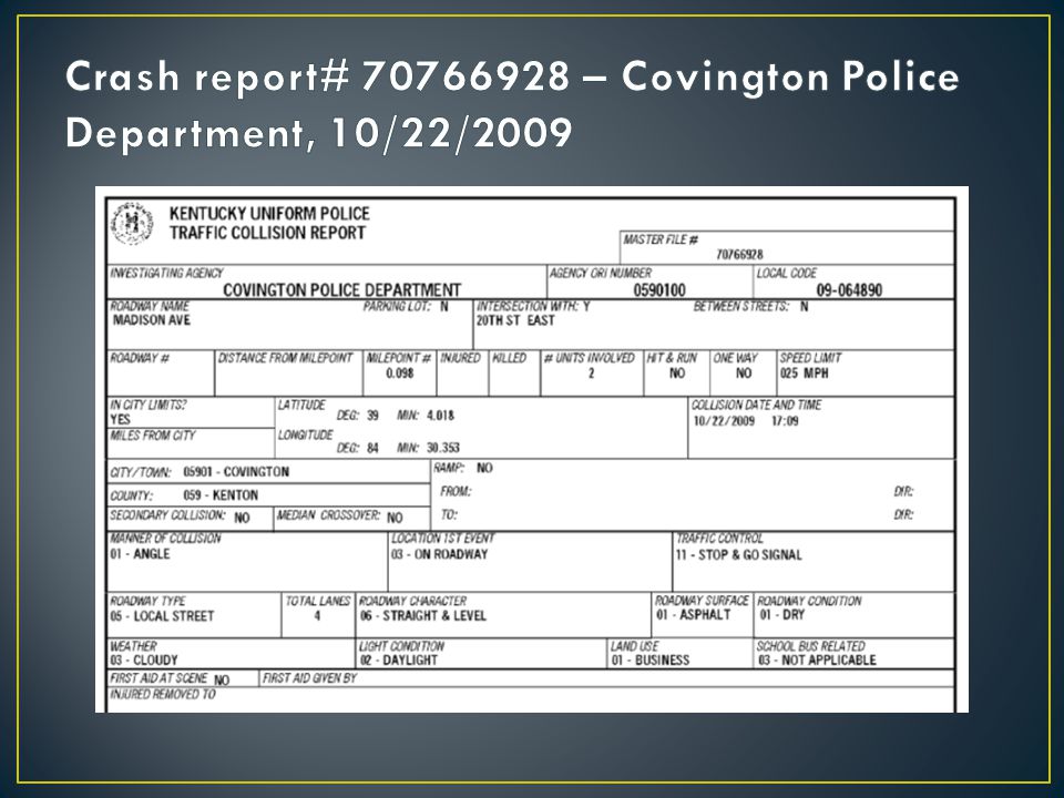
222 random crashes from 2009 were reviewed All had Lat/Long generated by the MapIt system This was considered the reported location The actual location was derived from: Report narratives Addresses Intersecting or between roads The accuracy of each location was classified: YES – within 500 feet of actual location NO – outside of 500 feet from actual location UNKNOWN – unable to determine actual location

8
Each report was classified as: Intersection Between Streets None 500 feet is useful for network screening but more accurate locations are preferred for individual crash analysis A range was given for each crash indicating accuracy of each presumed locations Definitive locations such as addresses had small or ranges of zero Larger ranges were used when the location was determined to be between two reference points

9
Was location Accurate?Type of Location Between streetsIntersectionNone Grand Total Yes100.0% 54.6%71.2% No0.0% 9.2%5.9% Unknown0.0% 36.2%23.0% Grand Total100.0%

10
If the unknown locations were removed 152 of the 167 or 92% were accurate 92% can be compared to a similar study conducted 6 years ago which yielded: 58% were correct by Lat/Long 55% were correct by CRMP

11
Lat/Long is not consistent with address/reference (12 crashes) No reference point (1 crash) These could be a result of the officer needing to "guess" where to click on the mapping system Additional reference systems could help minimize this error
 No reference point (1 crash) These could be a result of the officer needing to guess where to click on the mapping system Additional reference systems could help minimize this error")
12
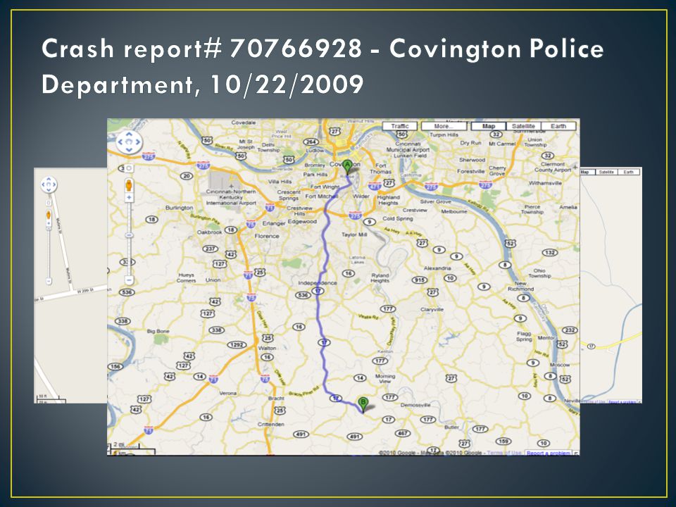
Latest data containing the MapIt-based location October 1 st, 2007 to December 31 st, 2009 334,354 crashes Data were plotted using CRMP data Lat/Long data was assigned to all plotted CRMP crashes The distance between the Lat/Long location and the CRMP location was calculated

15
Plotted In Reported County? YearNoYes 2007*2.7%97.3% 20081.1%98.9% 20090.3%99.7% Grand Total0.9%99.1% *2007 only represents 3 months of the year

16
Row Labels Average Distance (Feet) Average Distance (Miles)Crash Count 2007*16,1853.124,874 200840,7137.7112,434 20091,7930.3121,066 Grand Total20,1153.8258,374 *2007 only represents 3 months of the year
 Average Distance (Miles)Crash Count 2007*16, , , , , ,066 Grand Total20, ,374 *2007 only represents 3 months of the year")
17
The crash database was sorted by distance and several of the most egregious errors were examined There were two types of electronic reporting errors that yielded large distance between the CRMP and Lat/Long locations Lat/Long Glitch ‘Distance From’ Glitch

18
For several crashes one of the Lat/Long coordinates was off by -96 degrees Adding this value to these crashes plotted the crash very close to the CRMP location MFN of 70651040 reported longitude of 7.759983063 longitude based on the CRMP of -88.2399139 7.76 - 96 = -88.24 The data base actually showed “07.759983-01” This was only observed in 252 crashes, most of which were in 2008 The error was not observed since January of 2009. It is assumed to have been fixed.

19
This error was harder to quantify its frequency as the distance was not nearly as egregious It was noticed in about 700 crashes (presumed to be many more) The GPS coordinates were modified by the ‘distance from’ field The office should not need to use the ‘distance from’ field when using the MapIt system (it is used for CRMP) This error is currently repeatable Perhaps by design, but it was never noticed to be deliberate
 The GPS coordinates were modified by the ‘distance from’ field The office should not need to use the ‘distance from’ field when using the MapIt system (it is used for CRMP) This error is currently repeatable Perhaps by design, but it was never noticed to be deliberate")
20
Several of these errors were related to the officer entering the data wrong or the data being keyed into the system incorrectly There were 731 crashes with a Lat/Long minute value 60 or greater Over 400 crashes with noticeably bad Lat/Long Several crashes that had no minutes or seconds or suspicious values such as 30 minutes Although these represent a small number of crashes, they are a much higher proportion when only paper reports (about 27,000) are considered
 are considered")
21
If all crashes that were plotted outside of their reported county are removed, this distance reduces from 3.8 to 0.2 miles This implies that if a county check was performed before accepting a crash that the most egregious errors could be eliminated Most of the worst errors occurred prior to 2009 The average distance in 2009 would reduce from 0.3 miles to 0.1 miles by requiring this check There is a county bounding box check although it must not be required

22
Crashes indicating that the officer used the MapIt system and did not edit its location It would be expected that the distance between the CRMP and the Lat/Long locations would be ostensibly zero It would be expected to observe rounding and map projection errors that would yield some distance between the two locations Unexpectedly, however, there were 5,267 (4.4%) usable crashes in 2009 that used an unedited MapIt location, yet had a distance of 500 feet or more
 usable crashes in 2009 that used an unedited MapIt location, yet had a distance of 500 feet or more")
23
6 crashes with a distance over 4,000 miles (explained by the Lat/Long Glitch discussed earlier) There were 12 crashes with a distance of over 20 miles The average distance of this dataset was 6.6 miles (1.3 miles excluding the 6 with latitude/longitude errors) Several of these crashes were reviewed to determine the reason for these errors For 127of the crashes the error seemed to be related to ‘distance from’ error discussed above.
 There were 12 crashes with a distance of over 20 miles The average distance of this dataset was 6.6 miles (1.3 miles excluding the 6 with latitude/longitude errors) Several of these crashes were reviewed to determine the reason for these errors For 127of the crashes the error seemed to be related to ‘distance from’ error discussed above.")
27
A summary was performed by county-route combinations A count of each county-route was compared to the count of that county-route’s occurrence in all 2009 crashes A percentage was calculated based on these two counts The unmodified MapIt location database represents 4.4% of all 2009 crashes A percentage higher than 4.4% is overrepresented Several county-routes had very high percentages implying that there may be something wrong with these routes in the MapIt database

28
Appendix D-2. The County-Routes with 20 or More Crashes and an Unmodified MapIt Location in 2009 Ordered by Descending Percentage of All 2009 Crashes County-Route Number of Crashes in 2009 with Unmodified MapIt Location Number of Crashes in 2009Percent Bath @ KY-36232592.0 Kenton @ KY-107213915291.4 Hardin @ KY-300510711989.9 Lewis @ KY-8394783.0 Pulaski @ KY-914242982.8 Warren @ KY-185445974.6

29
Most of the location errors have been addressed and mitigated in KYOPS Analyze paper reports or electronic reports with modified MapIt locations The distance between the Lat/Long and CRMP should be zero for all unmodified MapIt The averages were not driven down by the frequency of such crashes

30
Location of the first harmful event Priority of roadways: 1.Interstates* 2.Parkways* 3.US routes* 4.KY routes* 5.All other roads Intersection and between used when available *The lower number should be used if both roads are the same priority

31
92% of all crashes were accurate compared to around 50% in the previous study Most of this improvement can be attributed to the implementation of the MapIt system in eCrash A large majority of incorrectly located were largely due to a lack of reference points The MapIt system currently requires user to know where they are on a map Identified errors should be investigated by KYOPS

32
Aerial photos Integrated GPS receivers Reference log data Mileposts, bridges, culverts, etc. Training QC of location data, state road preference (the importance) Contact specific agencies or evaluate county data ‘Distance From’ glitch Edits to check for county and distance between CRMP and GPS
 Contact specific agencies or evaluate county data ‘Distance From’ glitch Edits to check for county and distance between CRMP and GPS.")
33
Eric Green, M.S.C.E, P.E. Kentucky Transportation Center Research Engineer 140C Raymond Building University of Kentucky Lexington, KY 40506-0281 egreen@engr.uky.edu Phone: (859) 257-2680 Toll Free: (800) 432-0719 Fax: (859) 257-1815 egreen@engr.uky.edu www.ktc.uky.edu http://www.ktc.uky.edu/Reports/KTC_10_16_KSP3_10_1F.pdf
 Toll Free: (800) Fax: (859)")
Similar presentations