Download presentation
Presentation is loading. Please wait.

1
Starter: Sketch the map below with a pencil and label the countries. Please borrow a coloured pencil from the front if you don’t have one. China India Nepal Bangladesh Pakistan Bhutan

2
FLOODING IN BANGLADESH An example from an LEDC Flood event

3
Floods in Bangladesh- Over Many Years, but with a Close Look at 1998 and 2004 Learning Objectives: To be able to describe the location of Bangladesh To classify the causes, effects and responses to the floods To build upon personal learning and thinking skills (PLTS)
")
4
Starter As you watch the video, jot down some questions you have about the Bangladesh Floods in your books

5
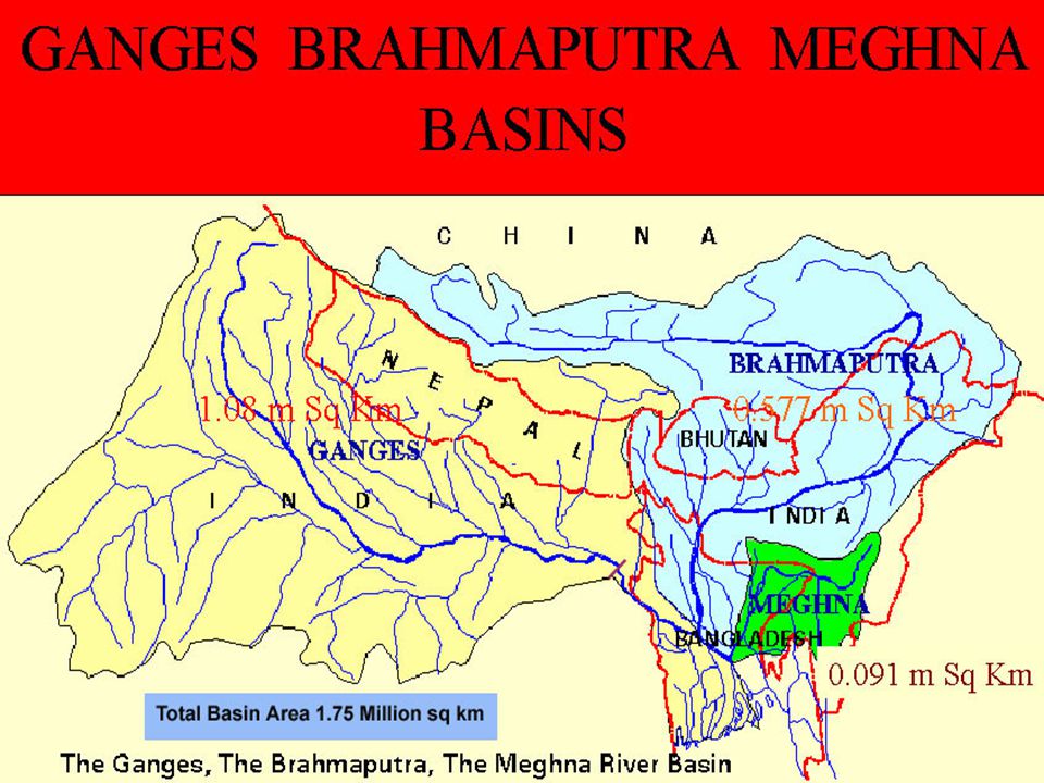
3 Great Rivers Ganges

6
Brahmaputra

7
Meghna

9
Heavy monsoon rains have caused devastation in Bangladesh. The port city of Chittagong has been particularly badly hit.

10
The city and surrounding areas have suffered both flooding and landslides.

11
Worst hit was a crowded shanty town near a military area.

12
Classification What do the following three terms mean…? 1.Cause 2.Effect 3.Response

13
Classification - an example! Biscuit classification: Bourbon Jaffa Cake Jammy dodger Digestive Hobnob Shortbread Custard Cream

14
Classification 1.Causes - what made the floods happen? 2.Effects - what problems did the floods bring? 3.Responses and Solutions - what did people have to do afterwards?

15
Cast Study Sheet

16
Task- Case Study Sheet You have 15 minutes to travel around the room and collect information from the sheets that have been printed around the room DO try and get at least some information for each box DO collect statistics Do NOT copy each information sheet word for word- there’s not enough time

17
Missing Any Information? Then fill it in now…. http://www.youtube.com/watch?v=DQQS qjpjm6I

18
Positive impact of flooding: Regular annual flooding is essential to people who live on the flood plain of these rivers, the farming season is planned around the floods, rice is a main crop and requires large quantities of water. Also, when the river floods it leaves behind fertile silt.

19
China India Nepal Bangladesh Pakistan Bhutan

21
CAUSES OF FLOODING

22
Bangladesh Government Distributed money and 400 tonnes of rice Relief supplies of fresh water, water purification tablets and sanitation services provided Aid Agencies Provided Boats to rescue people Supplied medicines Supplied clean drinking water Set up a medical treatment centre Distributed fodder for livestock Distributed food and plastic sheeting Planned a rehabilitation programme to repair and construct housing and provide sanitation Other Governments Gave aid including wheat, money, medicines, water tablets, house repair, sanitation and rehabilitation for farming and fishing MANAGING THE FLOOD - SHORT TERM

23
In 1989 the Bangladesh government working with several international agencies and the world bank produced a FLOOD ACTION PLAN (FAP): SHELTERS AND WARNING SYSTEMS Built 5000 flood shelters in high risk areas Improve flood forecasting system using satellite and computer technology Prepare flood disaster management plans which provide early warning and clear, effective instructions as to what people should do before, during and after a flood DAMS Building 7 new dams to control river flow and to hold back the monsoon rainwater in reservoirs The water would be used for irrigation and generating electricity MANAGING THE FLOOD - LONG TERM Flood Control 12-15 floodwater storage basins to hold floodwater diverted from main rivers Divide the land into compartments and control water flow through a system of channels by sluice gates and water pumps In the dry season water can be moved to farming areas requiring irrigation Embankments Complete and strengthen the embankments along all the main river channels to a height of up to 7 metres More than 7500km of embankments are already in place but repairs, heightening and new building would cost over $6 billion Other controls Pumping water out of the ground in the Himalayas during the dry season to create underground storage for the monsoon rains Replanting of forest cover in Nepal and Tibet
: SHELTERS AND WARNING SYSTEMS Built 5000 flood shelters in high risk areas Improve flood forecasting system using satellite and computer technology Prepare flood disaster management plans which provide early warning and clear, effective instructions as to what people should do before, during and after a flood DAMS Building 7 new dams to control river flow and to hold back the monsoon rainwater in reservoirs The water would be used for irrigation and generating electricity MANAGING THE FLOOD - LONG TERM Flood Control floodwater storage basins to hold floodwater diverted from main rivers Divide the land into compartments and control water flow through a system of channels by sluice gates and water pumps In the dry season water can be moved to farming areas requiring irrigation Embankments Complete and strengthen the embankments along all the main river channels to a height of up to 7 metres More than 7500km of embankments are already in place but repairs, heightening and new building would cost over $6 billion Other controls Pumping water out of the ground in the Himalayas during the dry season to create underground storage for the monsoon rains Replanting of forest cover in Nepal and Tibet")
24
Protection 5000 shelters Improve flood forecasting scheme Flood disaster management – early warning, clear instructions Dams – in Bangladesh and Nepal Flood control compartments Embankments

25
Info Card 1 Flood shelters save lives Flood shelters provide a safe place for almost everyone Flood shelters don’t protect land and property

26
Info Card 2 The plans are expensive and Bangladesh might get in debt trying to afford them Local people could make the flood shelters Flood shelters need to be well stocked with food Embankments trap rainwater and prevent it from reaching/ returning to the river - this can make flooding worse

27
Info Card 3 Flood shelters are cheap to construct Up to half a million Bangladeshi people will lose their land to reservoirs and embankments Water stored in reservoirs behind dams can be used to water crops (irrigation) Flood warning systems would give people instructions to people to tell them what to do before, during and after the flood
 Flood warning systems would give people instructions to people to tell them what to do before, during and after the flood")
28
Info Card 4 Water stored in reservoirs behind dams can be used to generate cheap electricity Building dams increases the build up of silt, this can make flooding worse

29
Info Card 5 Embankments strengthen the banks of the river so water stays in the river channel Embankments stop people fishing on the river Help would be given to people to plant crops for next year Dams control the river flow and hold back the monsoon rainwater in reservoirs

30
Info Card 6 The embankments could be up to 7m high in urban areas 5,000 flood shelters could be built in high risk areas If people can’t fish it will affect their livelihood

31
Info Card 7 Flood warning systems would give early warnings of the floods People would be taken to safety, given food and medical care Because this river sediment is very fertile, it is good for growing crops like rice - embankments would stop this

32
Info Card 8 Food, drinking water, tents and medicines would be available after the floods Not everyone would get the warning Providing emergency help when the floods arrive

33
Plenary- 8 Mark Question Please complete the tasks on the worksheet and then rewrite the 8 mark question in your books in a way that would achieve a level 3 mark

Similar presentations


 To categorise.>")


 team of Sarah Librea-USDA Foreign Agricultural Service (Team Leader), Jon Fripp.>")


>")


