Download presentation
Presentation is loading. Please wait.

1
The Relationships Between Plate Boundaries and Tectonic Landforms

2
Island arcs Volcanoes Mountains
The earth’s surface is covered with a variety of wonderful and interesting landforms… Island arcs Volcanoes Mountains

3
And valleys bordered by steep cliffs,
Just to name a few!

4
How did these landforms originate?
How does it relate to our dynamic, changing earth? …These are questions that curious and analytical scientific minds have only really been able to answer in the last years!

5
Courtesy of pictures from NASA’s website:
“Earth from Space” We are going to take a “Virtual Tour” of the Earth to explore these Tectonic Landscapes and put into “real-world” context what we have learned in class.

6
But first a review… An important modern theory about the forces that drive plate tectonics is that the plastic, partially melted asthenosphere is undergoing convection. This movement of materials below the earth’s lithosphere is thought to be causing the plates of the earth’s lithosphere to move too!

7
As you have learned, where there is upwelling of the asthenosphere, the crust above spreads apart, and new material from below bulges up into ridges. Where there is subsidence of the asthenosphere, the crust is being pulled down along with it to form depressions, or trenches. This can be visualized superbly in this diagram.

8
This movement of the astheno-sphere causes the lithosphere plates to be pulled apart or pushed together! This creates the different plate boundaries, which in turn creates the landscapes we see on earth today!

9
Let’s review the 3 types of plate boundaries we have discussed so we can better understand the pictures we are about to see.

10
Convergent: Where compression forces push the earth’s plates together
Plate Boundaries 1. Divergent: Where tension forces are pulling the earth’s plates apart. (where plates move away from each other) Convergent: Where compression forces push the earth’s plates together (where plates crash into each other) Transform: Where shearing forces cause the earth’s plates to slide past each other. (where plates rub against each other in opposite directions)
 Convergent: Where compression forces push the earth’s plates together. (where plates crash into each other) Transform: Where shearing forces cause the earth’s plates to slide past each other. (where plates rub against each other in opposite directions)")
11
How do scientists know where plate boundaries are, and of what type?
By studying where the earth is under stress. How do scientists know where the earth is under stress? By identifying where earthquakes are and how deep they are!

12
Shallow earthquakes are found along divergent, transform, and rift boundaries, and where continental crust is colliding. Deep earthquakes are found along what kind of zones?! * * *

13
O.K.! Enough Review! Let’s take off and look at some real-life landforms!
Our first stops will take us to CONVERGENT boundaries. Stop 1: Oceanic crust colliding into oceanic crust

14
COUNTDOWN…. 5 4 3 2 1

15
LIFTOFF!!!!

16
We are going to fly over Alaska and the Aleutian Islands
What features should we be looking for? Aleutian Islands

17
Unimak Island Sept Seen in this southwest-looking, low oblique photograph is Unimak Island, AK, the largest island in the Aleutian chain. The major volcano on the island (snow-capped peak in the center of the photograph), Shishaldin, rises approx ft (2860 m) and has been active during the last 175 years, with several eruption occuring recently. The volcano is locally known as “Smoking Moses.” At the southwestern end of the island is the snow-capped Pogromni Volcano. The blue lake situated in a large volcanic caldera, which can be seen midway between Pogromni and Shishaldin volcanoes, is the result of a now extinct volcano that collapsed.
, Shishaldin, rises approx ft (2860 m) and has been active during the last 175 years, with several eruption occuring recently. The volcano is locally known as Smoking Moses. At the southwestern end of the island is the snow-capped Pogromni Volcano. The blue lake situated in a large volcanic caldera, which can be seen midway between Pogromni and Shishaldin volcanoes, is the result of a now extinct volcano that collapsed.")
18
Unimak Island and Aleutian Islands, AK, Sept 1992
Unimak Island and Aleutian Islands, AK, Sept Three distinctive, snowcapped stratovolcanoes are easily identified in this near-vertical photograph of Unimak Island, one of many volcanic islands in the Aleutian archipelago. The Aleutian archipelago, formed by the collision of the Pacific Plate with the western extension of the North American Plate, forms a northern part of the Ring of Fire that encircles the Pacific Ocean. Unimak Island, the large island nearest the AK peninsula, is separated from the peninsula by Bechevin Bay, shown at the bottom of the photograph. Shishaldin Volcano is the westernmost and tallest of the three featured volcanoes. Isanolski Volcano is the middle volcano (8088 ft or 2465 m.) Unimak Island
 Unimak Island.")
19
Turn to page 5 in your Earth Science Reference Tables…
What tectonic feature do you see associated with the Aleutian Islands?

21
Volcanic Island Arcs are associated with trenches!
Why is this so?!

22
What type of lava would be extruding from these volcanoes
What type of lava would be extruding from these volcanoes? (See page 6 of your reference tables.)
")
23
Stops 2&3: Oceanic crust colliding with continental crust

24
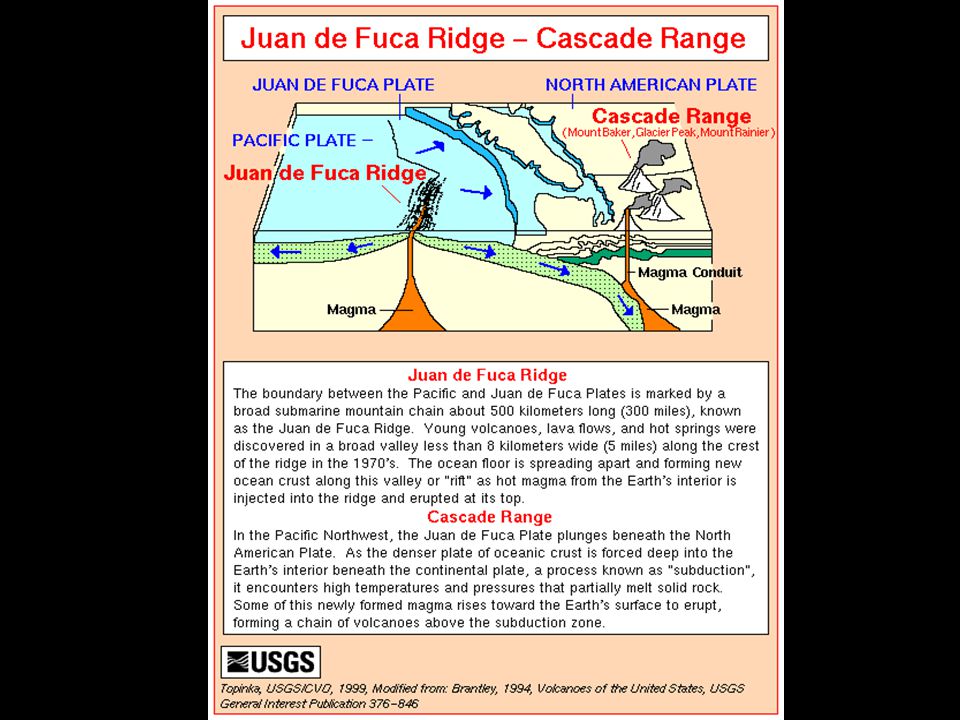
We will be visiting the state of Washington in order to view plate tectonic features that resulted when the Juan de Fuca Plate (oceanic crust) collided with the North American Plate (continental crust.) Based on the map to the right, and in the next slide, what features should we be looking for?

26
Cascade Range, Washington
Cascade Range, Washington, August The volcanic peaks of Mount Rainier (just right of the center of the image), Mount St. Helens (just to the top of the center of the image), and Mount Adams (near the left center of the image) in the Cascade Range of central and southern Washington, can be seen in this south-southwest-looking view. The Cascade Range, a part of the Pacific Ring of Fire, extends 700 miles (1125 km) from British Columbia, Canada, southward into northern CA. The Cascade Range was formed from colliding tectonic plates (N. America and Juan De Fuca) and volcanic activity, and these forces continue to make the Cascades rise. Mount Rainier at ft (4395 m) is the highest point in the range. Forests cover an extensive area of the Cascade Range. The small city of Hood River, Oregon, and the Columbia River Gorge can be seen at the left center of this image. The city of Portland, OR (barely discernible) and the Willamette River Valley are visible near the top left and top center of the image.
, Mount St. Helens (just to the top of the center of the image), and Mount Adams (near the left center of the image) in the Cascade Range of central and southern Washington, can be seen in this south-southwest-looking view. The Cascade Range, a part of the Pacific Ring of Fire, extends 700 miles (1125 km) from British Columbia, Canada, southward into northern CA. The Cascade Range was formed from colliding tectonic plates (N. America and Juan De Fuca) and volcanic activity, and these forces continue to make the Cascades rise. Mount Rainier at ft (4395 m) is the highest point in the range. Forests cover an extensive area of the Cascade Range. The small city of Hood River, Oregon, and the Columbia River Gorge can be seen at the left center of this image. The city of Portland, OR (barely discernible) and the Willamette River Valley are visible near the top left and top center of the image.")
27
Mount Rainier Mount Rainier, Washington, November Snow-covered Mt. Rainier, the tallest mountain in the Cascade Range at 14,410 ft (4395 m), can be seen in this low-oblique, west-southwest-looking photograph. Mount Rainier, a stratovolcano that has been dormant since 1850, has 26 active glaciers. Portions of Interstate Highway 90, Kachess Lake, and Cle Elum Lake are discernible near the bottom right. Scattered rectangular patterns are caused by the clearcutting practices of the timber companies in the region.
, can be seen in this low-oblique, west-southwest-looking photograph. Mount Rainier, a stratovolcano that has been dormant since 1850, has 26 active glaciers. Portions of Interstate Highway 90, Kachess Lake, and Cle Elum Lake are discernible near the bottom right. Scattered rectangular patterns are caused by the clearcutting practices of the timber companies in the region.")
28
Mount Saint Helens Mount Saint Helens National Volcano Monument, WA, Sept This spectacular, near-vertical photograph shows the 8360 foot (2548 m) Mt. St. Helens volcano with its developing lava dome and expansive pumice plain. The grayish-colored area of the blast zone from the 1980 eruption extends outward to the northwest, north, and northeast of the volcano. North of the volcano lie three major lakes from east to west—Spirit Lake (the largest), the elongated Coldwater Lake, and Castle Lake. South of Mt. St. Helens are clear-cut patterns (lumbering) interspersed throughout the darker green forested region of the Gifford Pinchot National Forest. Mount Saint Helens erupted on May 18, 1980, at 8:32 a.m. Pacific Time. A series of moderate-to-severe earthquakes preceded the eruption, sending the north side of the mountain cascading down towards Spirit Lake. The avalanche, the largest ever observed in the Western Hemisphere, weakened the magma chambers within the volcano, causing a northward lateral and vertical explosion that destroyed over 270 square miles (700 square kilometers) of forest in 5 seconds, and sent a billowing cloud of ash and smoke 70,000 feet (21,000 m) into the atmosphere. Visible on this photograph and situated between the caldera of the volcano and Spirit Lake is a large, grayish, pumice plain. This plain is made up of volcanic mud, ash, and debris that burned the original Toutle River Valley to a depth of 1000 feet (300 m). The avalanche of debris and ash raised the level of Spirit Lake 200 feet (61 m) over its pre-eruption level, blocked the flow of Coldwater Creek, and formed the now elongated 300 foot deep (91 m deep) Coldwater Lake. This lake is located approximately 7 miles (11 km) from the volcano. The lava dome,, which is visible in the center of the volcano crater, has attained a height of 1700 ft (518 m) since it began to form in the early 1980’s. Though not clearly visible on this photograph, vegetation has returned and is flourishing in most areas of the blast zone, with the exception of the pumice plain area.
 Mt. St. Helens volcano with its developing lava dome and expansive pumice plain. The grayish-colored area of the blast zone from the 1980 eruption extends outward to the northwest, north, and northeast of the volcano. North of the volcano lie three major lakes from east to west—Spirit Lake (the largest), the elongated Coldwater Lake, and Castle Lake. South of Mt. St. Helens are clear-cut patterns (lumbering) interspersed throughout the darker green forested region of the Gifford Pinchot National Forest. Mount Saint Helens erupted on May 18, 1980, at 8:32 a.m. Pacific Time. A series of moderate-to-severe earthquakes preceded the eruption, sending the north side of the mountain cascading down towards Spirit Lake. The avalanche, the largest ever observed in the Western Hemisphere, weakened the magma chambers within the volcano, causing a northward lateral and vertical explosion that destroyed over 270 square miles (700 square kilometers) of forest in 5 seconds, and sent a billowing cloud of ash and smoke 70,000 feet (21,000 m) into the atmosphere. Visible on this photograph and situated between the caldera of the volcano and Spirit Lake is a large, grayish, pumice plain. This plain is made up of volcanic mud, ash, and debris that burned the original Toutle River Valley to a depth of 1000 feet (300 m). The avalanche of debris and ash raised the level of Spirit Lake 200 feet (61 m) over its pre-eruption level, blocked the flow of Coldwater Creek, and formed the now elongated 300 foot deep (91 m deep) Coldwater Lake. This lake is located approximately 7 miles (11 km) from the volcano. The lava dome,, which is visible in the center of the volcano crater, has attained a height of 1700 ft (518 m) since it began to form in the early 1980’s. Though not clearly visible on this photograph, vegetation has returned and is flourishing in most areas of the blast zone, with the exception of the pumice plain area.")
29
A similar situation exists in western South America, but the plates involved are different.
What plates are involved in this collision between oceanic and continental crust?

30
Now we’re off to Chile and Peru to check out the landforms there!
Stop 3: South America

31
Chile Southern Andes Mountains, Central Valley, Chile, Many volcanic peaks, snowcapped ridges, and glacial lakes of the southern Andes are visible in this southeast-looking view. Between the mountains and the Pacific Ocean (lower right), the long, narrow, fertile Central valley of Chile appear distinctly greener—on the wet side of the mountains—compared with the dry plains of Patagonia (top left). The Central Valley stretches southward to where it drops below sea level into the Gulf of Ancud (upper right). The glacial lakes of the forested slopes of the Andes begin with Lakes Colico, Caburga, and Villarrica (bottom left portion of the image.) Between Lakes Villarrica and Calafquen is the snow-covered stratovolcano Villarrica which is presently active. The large lake with the small island near it is Lake Ranco. Just to the south-southeast of Lake Ranco and at the center of the image is the Cordillera Nevada. The narrow complex lake on the Patagonian side of the Cordillera Nevada is Lake Nahuel Huapi. The large lake at the southern end of the Central Valley is Llanquihue. Covering the upper left and top center of the image is the Patagonian Plateau.
, the long, narrow, fertile Central valley of Chile appear distinctly greener—on the wet side of the mountains—compared with the dry plains of Patagonia (top left). The Central Valley stretches southward to where it drops below sea level into the Gulf of Ancud (upper right). The glacial lakes of the forested slopes of the Andes begin with Lakes Colico, Caburga, and Villarrica (bottom left portion of the image.) Between Lakes Villarrica and Calafquen is the snow-covered stratovolcano Villarrica which is presently active. The large lake with the small island near it is Lake Ranco. Just to the south-southeast of Lake Ranco and at the center of the image is the Cordillera Nevada. The narrow complex lake on the Patagonian side of the Cordillera Nevada is Lake Nahuel Huapi. The large lake at the southern end of the Central Valley is Llanquihue. Covering the upper left and top center of the image is the Patagonian Plateau.")
32
Lascar Volcano, Chile July 1995
Lascar Volcano, Chile July With the exception of the road (light-colored, linear feature) along the end of the great salt flat, Salar De Atacama (left middle), little evidence of human presence can be observed in this remote and arid region of northern Chile. Characterized by dramatic elevation changes, numerous volcanic features, and a variety of eolian and fluvial landforms can be identified in this arid environment. The western edge (left) of the image is roughly 7500 ft (2286 m) above sea level. Just 25 miles (40 km) to the east, the average elevation of the Andes Mountains increases to approx. 14,000 ft (5486 m). Several stratovolcanoes, including Lascar Volcano, may be recognized by a pronounced radial drainage (erosional) pattern on the flanks of the volcanoes. Lascar Volcano, located (slightly above and left of center) by the V-shaped ash plume that extends eastward from the April 1993 eruption, is barely discernible. Several highly reflective (whitish) salars (salt flats) are scattered throughout the high altitude terrain. The darker, somewhat paralleling lines, aligned east-west along the western slopes of the Andes Mountains (left edge) are fluvial landforms; while the less distinct features (paralleling lines in the upper right corner) are the result of eolian processes.
 along the end of the great salt flat, Salar De Atacama (left middle), little evidence of human presence can be observed in this remote and arid region of northern Chile. Characterized by dramatic elevation changes, numerous volcanic features, and a variety of eolian and fluvial landforms can be identified in this arid environment. The western edge (left) of the image is roughly 7500 ft (2286 m) above sea level. Just 25 miles (40 km) to the east, the average elevation of the Andes Mountains increases to approx. 14,000 ft (5486 m). Several stratovolcanoes, including Lascar Volcano, may be recognized by a pronounced radial drainage (erosional) pattern on the flanks of the volcanoes. Lascar Volcano, located (slightly above and left of center) by the V-shaped ash plume that extends eastward from the April 1993 eruption, is barely discernible. Several highly reflective (whitish) salars (salt flats) are scattered throughout the high altitude terrain. The darker, somewhat paralleling lines, aligned east-west along the western slopes of the Andes Mountains (left edge) are fluvial landforms; while the less distinct features (paralleling lines in the upper right corner) are the result of eolian processes.")
33
Huacho Area, Peru, May This particular section of the Peruvian coast northwest of Lima is located in a desert climate. Here it is so arid that only the intermittently flowing rivers provide adequate moisture to support irrigated agriculture in the river valleys and floodplains (note the darker linear features aligned east-west in the image.) Many of the deeply incised, short flowing rivers frop dramatically in elevation from 15,000 feet (4572 m) elevation in the Andes Mountains to sea level in less than 50 miles (80 km).
 Many of the deeply incised, short flowing rivers frop dramatically in elevation from 15,000 feet (4572 m) elevation in the Andes Mountains to sea level in less than 50 miles (80 km)..")
34
Look at your reference table again
Look at your reference table again. What feature do you see on the west side of South America that is associated with convergent boundaries and the subduction that results? What is probably happening to the asthenosphere here?

35
Again, what type of lava would be extruding from these volcanoes in Washington State and western South America?

36
Stop 4: Continental crust colliding with continental crust
What features do we expect to find here?

37
We’re off to Southeastern Asia, one of the best places to observe this type of plate boundary!
China India Nepal

38
Himalayas India China Tibetan Plateau and Himalayas, China, October The Himalayas and the Tibetan Plateau shown in this photograph were formed and continue to be modified by the convergent collision of two of the world’s great continental tectonic plates, the Eurasian and the Indian-Australian. As a result of this collision that started more than 65 million years ago, the average elevation of the Tibetan Plateau (shades of brown and numerous deep blue lakes) in the intermountain valleys is approx. 16,000 ft (4880 m). The lakes are fed by the snowmelt from the higher mountain ridges and peaks. Words like treeless, cold, barren, windswept, and desolate are good descriptors of the harsh environment that exists on this elevated plateau. Part of the highest mountains in the world, and sometimes called the “rooftop of the world,” the Himalayas create a formidable barrier southwest of the Tibetan Plateau. The snowcapped Himalayas trend in a southeast-northwest arc with more than 30 peaks rising to heights of 24,000 feet (7300 m). Some clouds along the lower foothills of the southwest side of the Himalayas and some snowcapped mountain ridges and peaks are visible in the photograph. Towards the horizon, hazy and dusty conditions seem to exist on the Indo-Gangetic Plain of northern India (southwest) and the Takla Makan Desert of western China (northwest.)
 in the intermountain valleys is approx. 16,000 ft (4880 m). The lakes are fed by the snowmelt from the higher mountain ridges and peaks. Words like treeless, cold, barren, windswept, and desolate are good descriptors of the harsh environment that exists on this elevated plateau. Part of the highest mountains in the world, and sometimes called the rooftop of the world, the Himalayas create a formidable barrier southwest of the Tibetan Plateau. The snowcapped Himalayas trend in a southeast-northwest arc with more than 30 peaks rising to heights of 24,000 feet (7300 m). Some clouds along the lower foothills of the southwest side of the Himalayas and some snowcapped mountain ridges and peaks are visible in the photograph. Towards the horizon, hazy and dusty conditions seem to exist on the Indo-Gangetic Plain of northern India (southwest) and the Takla Makan Desert of western China (northwest.)")
40
Mount Everest 29,035 feet tall! (8850 meters)
")
41
Use your reference table to determine what plates are colliding to form the Himalayas.

42
Now we have reached the second part of our journey:
Stops 5&6: Exploring DIVERGENT boundaries…

43
A flight over part of Africa’s Rift Valley will demonstrate this.

44
First, find the East African Rift on your reference table and determine what plate the rift is found on.

45
Here are some volcanoes from the Rift Valley.
Knowing this is a divergent zone, what type of lava will extrude from them? Steep cliff of rift valley Lengai Volcano

47
And here are some dramatic pictures of the lava from these volcanoes!

49
…And now to explain how rifting can form volcanoes AND large lakes…

50
Water filled into the gap, creating a freshwater lake.
The uprising asthenosphere here has caused tension forces which have pulled apart the continental crust. ..and magma coming from the spreading center can form volcanoes! The brittle crust has fractured and a section in the middle has downfaulted into the developing gap (rift.) Water filled into the gap, creating a freshwater lake. There are two stunning examples of this in Africa!
 Water filled into the gap, creating a freshwater lake. There are two stunning examples of this in Africa!")
51
Stop 5: Malawi, Africa

52
Lake Malawi Lake Malawi (Lake Nyasa), Malawi Dec This low-oblique, southeast-looking photograph shows Lake Malawi, one of the many elongated lakes that form part of the Great Rift Valley of East Africa. The lake, bounded by steep mountains on all sides except the southern end, is approx. 360 miles long (580 km), averages 25 miles (40 km) in width, and has a maximum depth of 2316 ft (706 m). Lake Malawi is drained at the south end by the Shire River, which eventually empties into the Zambezi River. The lake and its steep-sloped shoreline were created by the faulting that caused an upward thrust as the valley floor subsided between the slopes. The darker area along the northwest coast of the Lake is the Nyika Plateau, which has several elevations more than 8000 ft (2440 m) above sea level. Landlocked Malawi extends along the entire west coast of the lake. The large Luangwa River basin is visible as it drains to the southwest. Immediately west of the Luangwa River Valley stand the northeast-southwest-trending Muchinga Mountains with their dark ridgeline and maximum elevations reaching 6000 feet (1830 m) above sea level. Northwest of this mountain range, drainage is to the north and west into the much larger Zaire (Congo) River watershed.
, Malawi Dec This low-oblique, southeast-looking photograph shows Lake Malawi, one of the many elongated lakes that form part of the Great Rift Valley of East Africa. The lake, bounded by steep mountains on all sides except the southern end, is approx. 360 miles long (580 km), averages 25 miles (40 km) in width, and has a maximum depth of 2316 ft (706 m). Lake Malawi is drained at the south end by the Shire River, which eventually empties into the Zambezi River. The lake and its steep-sloped shoreline were created by the faulting that caused an upward thrust as the valley floor subsided between the slopes. The darker area along the northwest coast of the Lake is the Nyika Plateau, which has several elevations more than 8000 ft (2440 m) above sea level. Landlocked Malawi extends along the entire west coast of the lake. The large Luangwa River basin is visible as it drains to the southwest. Immediately west of the Luangwa River Valley stand the northeast-southwest-trending Muchinga Mountains with their dark ridgeline and maximum elevations reaching 6000 feet (1830 m) above sea level. Northwest of this mountain range, drainage is to the north and west into the much larger Zaire (Congo) River watershed.")
53
And next to Tanzania…

54
Lake Tanganyika Lake Tanganyika, Tanzania. June This east-looking high-oblique photograph features Lake Tanganyika—the second deepest freshwater lake in the world with a maximum depth of 4710 ft (1436 m) and the longest lake in the world, stretching 410 miles (660 km) north to south. Its width varies between miles (16-72 km). The lake, bordered on either side by steep slopes, fills a long, narrow trough in the western arm of Africa’s Great Rift Valley and supports a thriving fishing industry. The lake basin, a landform in which a block of the Earth’s crust dropped down between blocks that rise on either side, began to form nearly 25 million years ago as part of the Great Rift Valley.
 and the longest lake in the world, stretching 410 miles (660 km) north to south. Its width varies between miles (16-72 km). The lake, bordered on either side by steep slopes, fills a long, narrow trough in the western arm of Africa’s Great Rift Valley and supports a thriving fishing industry. The lake basin, a landform in which a block of the Earth’s crust dropped down between blocks that rise on either side, began to form nearly 25 million years ago as part of the Great Rift Valley.")
55
And the last part of our journey… Stop 7: A TRANSFORM BOUNDARY
We’re still in Africa—Zimbabwe this time!

56
Movement that occurs along a transform boundary:

57
Where is the evidence for a transform fault in this area of Zimbabwe?

58
Great Dike, Zimbabwe, January 1993
Great Dike, Zimbabwe, January The Great Dike of Zimbabwe is a linear geographical feature that is easily recognizable running 300 miles (483 km) north-south through the midsection of Zimbabwe. This photograph shows only the southernmost extent of the Great Dike. The highly mineralized composition of the dike (igneous rock) makes this an important economic region for Zimbabwe. Copper, asbestos, chromium, gold, and platinum are some of the minerals that make up the strategic mineral reserves found throughout this region. There is visual evidence of east-west faulting that has occurred at several points along the Great Dike. Much narrower, paralleling mineralized veins observed east and west of the Great Dike exhibit the same horizontal displacement as the much broader dike.
 north-south through the midsection of Zimbabwe. This photograph shows only the southernmost extent of the Great Dike. The highly mineralized composition of the dike (igneous rock) makes this an important economic region for Zimbabwe. Copper, asbestos, chromium, gold, and platinum are some of the minerals that make up the strategic mineral reserves found throughout this region. There is visual evidence of east-west faulting that has occurred at several points along the Great Dike. Much narrower, paralleling mineralized veins observed east and west of the Great Dike exhibit the same horizontal displacement as the much broader dike.")
59
And our final stop… A PASSIVE CONTINETNAL MARGIN

60
Long Island, New York November 1994 The fourth largest island of the United States and the largest outside of Alaska and Hawaii, Long Island can be seen in this northeast-looking view. Long Island is 118 miles (190 km) long, 12 to 20 miles (19 to 32 km) wide, and covers an area of 1723 sq. miles (4463 sq. km). Most of northern Long Island is made up of glacial deposits forming small hills and cliffs and indented bays. The southern portions of Long Island are low-lying out-wash plains of glacial deposits consisting of long sandy beaches, backed by dunes and shallow lagoons. Sand and gravel are quarried from the island’s glacial deposits. Commercial fishing and recreation are also important commodities of the island. Long Island Sound, a former river valley, separates Long Island from the southern coast of the state of Connecticut. The New York/Newark Metropolitan areas are discernible extending north to south along the left (western) edge of the image.
 long, 12 to 20 miles (19 to 32 km) wide, and covers an area of 1723 sq. miles (4463 sq. km). Most of northern Long Island is made up of glacial deposits forming small hills and cliffs and indented bays. The southern portions of Long Island are low-lying out-wash plains of glacial deposits consisting of long sandy beaches, backed by dunes and shallow lagoons. Sand and gravel are quarried from the island’s glacial deposits. Commercial fishing and recreation are also important commodities of the island. Long Island Sound, a former river valley, separates Long Island from the southern coast of the state of Connecticut. The New York/Newark Metropolitan areas are discernible extending north to south along the left (western) edge of the image..")
61
Greenlawn Long Island, New York Spring-Summer 1996 The urban sprawl of central Long Island can be seen in this northwest-looking view. Long Island is made up of glacial moraines and outwash plains. Northern Long Island (upper right) is marked with wooded low hills and low cliffs, and is deeply indented with bays. Southern Long Island has long beaches, backed by dunes and shallow lagoons. Near the upper right of the image, Huntington Bay and Eatons Neck point are discernible. Near the bottom center of the image, the western portion of the Fire Island national Seashore backed by Great South Bay is visible. Extensive beaches backed by South Oyster Bay can be seen near the center left of the image. Numerous highways are discernible traversing the image from west to east through many small cities and urban areas. The wooded area visible near the bottom right of the image is Connetquot River State Park.
 is marked with wooded low hills and low cliffs, and is deeply indented with bays. Southern Long Island has long beaches, backed by dunes and shallow lagoons. Near the upper right of the image, Huntington Bay and Eatons Neck point are discernible. Near the bottom center of the image, the western portion of the Fire Island national Seashore backed by Great South Bay is visible. Extensive beaches backed by South Oyster Bay can be seen near the center left of the image. Numerous highways are discernible traversing the image from west to east through many small cities and urban areas. The wooded area visible near the bottom right of the image is Connetquot River State Park.")
62
Home Sweet Home!

63
In Summary… Wait a second…I’m tired from all this running around and being a tour guide…you do it!!! 1. What are the three main plate boundaries? Describe the movement at each. 2. How does each plate boundary affect what type of landscape results? Give specific examples for each one! 3. Explain how the asthenosphere drives plate tectonics.

Similar presentations


 Divergent Boundary (Ridge) 2)>")


- What is a mid ocean ridge? TABLE 2 (8)-What is.>")

