Download presentation
Presentation is loading. Please wait.

1
Aim: How has geography affected human development? Vocabulary: The bolded words in this slide show.

2
Where are we? Room 411

3
How good are your geography skills?

4
Label: The 7 continents The 4 Oceans Identify the following regions: South Asia, East Asia, Southeast Asia, Southwest Asia (The Middle East), Central Asia, Sub-Saharan Africa, Eastern Europe, Western Europe, Latin America, Oceania
, Central Asia, Sub-Saharan Africa, Eastern Europe, Western Europe, Latin America, Oceania")
5
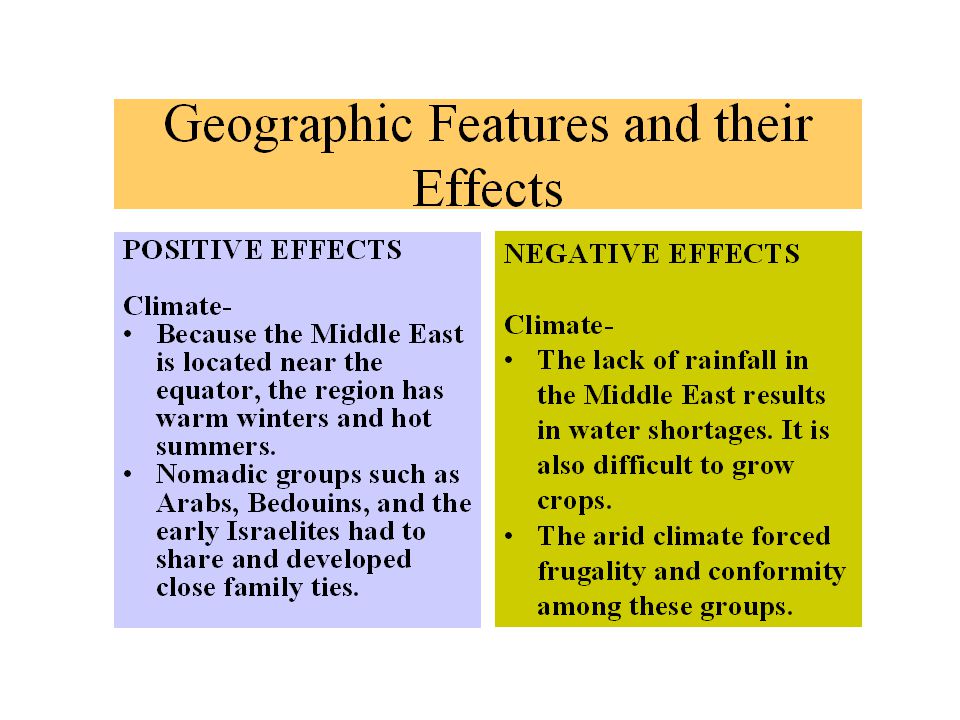
Geographic Determinism-Geography was the primary force behind a society’s development.

6
Just to clear things up… Geography IS really important and it DOES impact people and their development… But did the Inca starve to death because they didn’t have flat land to farm on? No! So you see, geographic conditions don’t always prevail… http://coe.fgcu.edu/students/webb/meso/inca.htm

7
The Human Impact on the Environment Resource consumption and Resource extraction Producing pollution Forest clearing Irrigation Agriculture Mining How do these activities demonstrate That humans shaped their environment?

8
Oceans, Seas, and Rivers Before the world was industrialized, water transport was an easier, cheaper, and better method of travel than overland. Rivers provided food (fish) and water to drink. Rivers were crucial in the development of agriculture and the establishment of cities. Rivers allowed for the movement of people and goods (resulting in cultural diffusion), and connected communities to each other.
 and water to drink. Rivers were crucial in the development of agriculture and the establishment of cities. Rivers allowed for the movement of people and goods (resulting in cultural diffusion), and connected communities to each other..")
9
Arctic Ocean Extremely difficult to navigate because it is packed in ice most of the year. Early European explorers sought the Northwest Passage but it is barely usable.

10
Indian Ocean The Harappans sailed through one of its seas, the Arabian Sea, to trade with Sumer. Malay sailors, Chinese, Muslim, and European traders used the ocean’s monsoon winds to guide them. Africans also traded via this ocean. Commercial rivalries between the Dutch, Portuguese, and Muslim sailors in the 17 th century.

11
Atlantic Ocean Columbus’ voyages caused a lot of exchange between the Eastern and Western hemispheres. Encounters between Europeans, Americans, and Africans. The Mediterranean, joined to the Atlantic, was important to Middle Eastern and Greco-Roman civilizations.

12
Pacific Ocean World’s largest ocean. Ancient Polynesians came to Oceania. Societies of East and Southeast Asia used the Sea of Japan and the South China and East China Seas. World Wars used the Pacific islands for strategic purposes. Painting Tahitian Women on the Beach by Paul Gauguin-Musee d’Orsay Image-wikipedia

13
Major Geographic Features of the Middle East

14
http://www.rethinkingschools.org/just_fun/games/mapgame.html

15
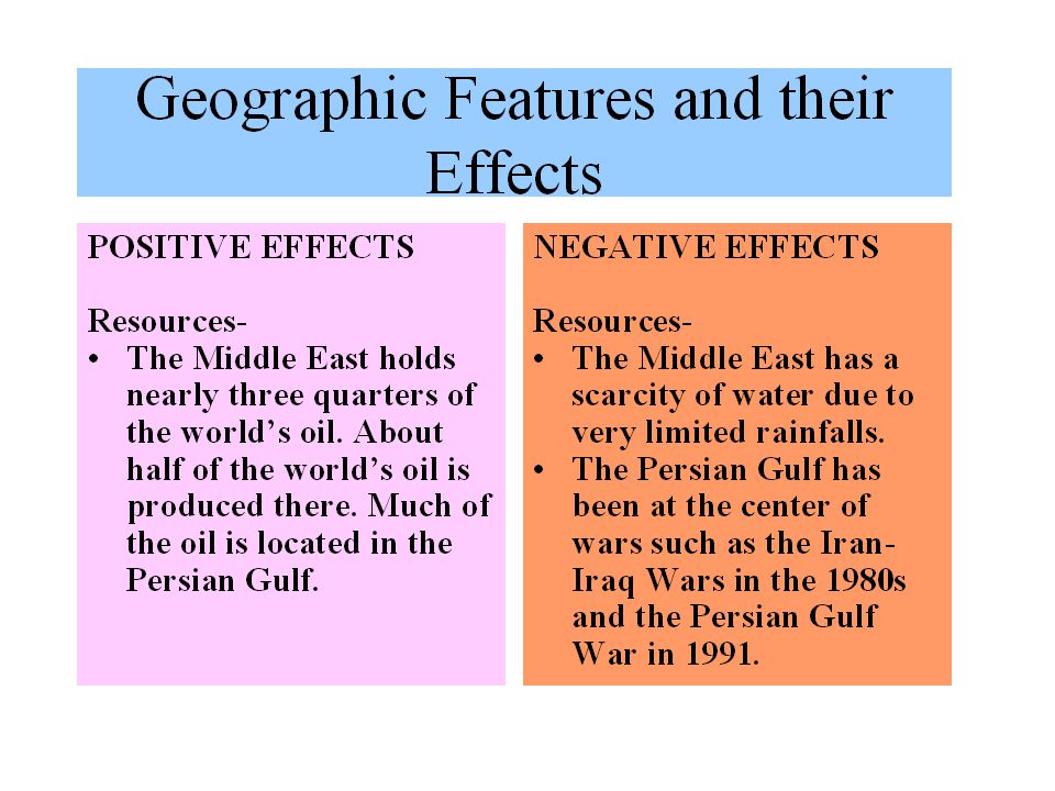
The Middle East is at the “crossroads of three continents: Europe, Africa, and Asia. This region is about twice the size of the United States. There are two strategic waterways in the Middle East: The Suez Canal (connecting Europe to South Asia) and the Dardanelles and Bosporus Straits connecting the Black Sea with the Mediterranean Sea. http://www.infoplease.com/atlas/middleeast.html
 and the Dardanelles and Bosporus Straits connecting the Black Sea with the Mediterranean Sea.")
19
The lack of natural barriers in the Fertile Crescent enabled migrations and invasions. The diversity of the people in the Fertile Crescent made it difficult to unite them into a single nation. The Fertile Crescent has also become known as the “cradle of civilization.” Mesopotamia was in the eastern end of the Fertile Crescent (modern day Iraq). Historyforkids.org
. Historyforkids.org.")
20
Cia.gov

25
Major Geographic Features Of Africa Google Images

26
Africa http://www.sheppardsoftware.com/African_Geography.htmhttp://www.sheppardsoftware.com/African_Geography.htm Geography Quizzes - Fun Map http://www.topix.net/who/regis-philbin

27
The Sahara Desert is the world’s largest desert. The Sahara separated the people who lived north and south of it. People south of the Sahara became fairly isolated from Europe and Asia while people north of it have been part of the Mediterranean world.

28
Sahara Desert Erfoud, Morocco (Late afternoon-sand dunes) http://www.maion.com/photography/morocco/dunes_pictures.html The Sahara Desert can get as hot as 130 degrees Fahrenheit! Rand McNally Intermediate Geography and Map Activities

29
High temperatures and heavy rains Barrier to communication and transportation Deserts and Rain Forests have made Africa not as densely populated as other continents Hindered Africa’s economic development Tropical Rain Forests http://www.enchantedlearning.com/subjects/rainforest/Where.shtml

30
Rivers The Nile River is the longest River spanning about 4,000 miles. Until 2004 no one had navigated its entire length! Many African rivers are too dangerous to travel because of rapids and falls. http://www.enchantedlearning.com/geography/outlinemaps / Rand McNally Geography

31
http://touregypt.net/magazine/mag05012001/magf4a.htm The Nile River

32
Danger Ahead! Some of Africa’s rivers are very dangerous to travel because of the rapids and falls (Victoria Falls located on the Zambezi River, the Mutarazi Falls in Zimbabwe, and the Tugela Falls and Mpumalanga Falls- both in South Africa) http://worldatlas.com/webimage/countrys/africa/zw.htm Victoria Falls (Zimbabwe)
 Victoria Falls (Zimbabwe).")
33
Hymn to the Nile "Hail to you Hapy, Sprung from earth, Come to nourish Egypt…Food provider, bounty maker, Who creates all that is good!…Conqueror of the Two Lands, He fills the stores, Makes bulge the barns, Gives bounty to the poor." (from the Middle Kingdom [2040-1640 BCE] hymn as translated by Lichtheim) http://touregypt.net/magazine/mag05012001/magf4a.htm
![Hymn to the Nile Hail to you Hapy, Sprung from earth, Come to nourish Egypt…Food provider, bounty maker, Who creates all that is good!…Conqueror of the Two Lands, He fills the stores, Makes bulge the barns, Gives bounty to the poor. (from the Middle Kingdom [ BCE] hymn as translated by Lichtheim)](http://images.slideplayer.com/16/5262913/slides/slide_33.jpg "Hymn to the Nile Hail to you Hapy, Sprung from earth, Come to nourish Egypt…Food provider, bounty maker, Who creates all that is good!…Conqueror of the Two Lands, He fills the stores, Makes bulge the barns, Gives bounty to the poor. (from the Middle Kingdom [ BCE] hymn as translated by Lichtheim)")
34
Importance of the Nile People in Egypt settled along the Nile River Provided water for drinking and irrigation Annual floods left rich deposits of silt that kept agricultural land fertile Highway for travel People prayed in pre dynastic times to Osiris (later known as Hapi) for sustenance Hapi http://touregypt.net/magazine/mag05012001/magf4a.htm
 for sustenance Hapi")
35
Coastline Africa has a long coastline that spans thousands of miles. The continent, however, lacks natural harbors where ships can enter and leave a port. This has made trade with others difficult. Cia.gov

36
Savanna A large part of sub- Saharan Africa is savanna. Most African communities and most wildlife are situated there. The distribution of fertile and infertile savannas in Africa. Dark-shaded areas are broad-leaf, nutrient-poor, savannas; striped areas are fine-leaf, nutrient-rich savannas. http://www.nrel.colostate.edu/projects/bas/Models/Africamap.html http://worldatlas.com/webimage/countrys/africa/bw.htm

37
Climate Much of sub-Saharan Africa is near the equator and has hot summers and warm winters. Deserts receive too little rain for agriculture while rain forests get too much. A striking African woman uses cream made from ground bark to provide moisturizing protection from Mozambique Island's equatorial sun. http://plasma.nationalgeographic.com/places/photos/photo_mozambique_mozambique.html

38
Resources What kinds of natural resources can be found in Africa? http://exploringafrica.matrix.msu.edu/teachers /curriculum/m6/natural_resources.html

39
Think about it… Why do you think natural resources have been both good and bad for Africa’s development?

40
The Major Geographic Features Of Latin America

41
Where is Latin America? Geographically speaking, Latin America is South America and the Caribbean (West Indies). Culturally speaking, Latin America includes Mexico well. Geographically, however, Mexico is part of North America.
. Culturally speaking, Latin America includes Mexico well. Geographically, however, Mexico is part of North America..")
42
Google Images

43
Describe the geographic effects of mountains.

44
Andes Mountains The Andes have isolated South America for much of its history. The Inca used terrace farming to grow food along the Andes Mountains. The Andes acted as a geographic barrier, and hindered attempts to unify people in Latin America. http://www.lib.utexas.edu/maps/americas/southamerica_ref802636_1999.jpg

45
Climate Much of Latin America is near the equator but high altitudes and winds keep it from being too hot. More people live in higher altitudes where the temperatures are comfortable. The tropical West Indian climate enables the production of sugar. For this reason African slaves were brought to Latin America.

46
Box 1: Physical Geography of Latin America Mountain AreasCountries included 1. Andes MountainsVenezuela, Colombia, Ecuador, Peru, Bolivia, Chile, Argentina. 2. Brazilian HighlandsMountain areas in the Northeast, Southwest and South. 3. Central American HighlandsCountries of Central America. 4. Sierra Madres and Mexican HighlandsMountain areas of the Sierra Madres (3), ranges and highland areas of the Pacific coast. 5. Caribbean Sierras and highlandsCountries of the Caribbean and island territories. http://www.fao.org/docrep/meeting/x4442e.htm Because of their altitude, mountains regulate local climates and determine climatic conditions creating special biospheres and ecosystems that impact directly on medium- and low-lying areas. The geomorphologic and terrestrial structure of these areas renders them unstable. They also include areas of water catchments, which determine water quality and supply and thus influence the maintenance of local production capacity and the quality of life of local inhabitants. The mountain areas have a wide array of ecosystems, in addition to mineral and forest resources that can be exploited in many ways. Their natural beauty also makes them attractive to tourism and for recreational activities.
, ranges and highland areas of the Pacific coast. 5. Caribbean Sierras and highlandsCountries of the Caribbean and island territories. Because of their altitude, mountains regulate local climates and determine climatic conditions creating special biospheres and ecosystems that impact directly on medium- and low-lying areas. The geomorphologic and terrestrial structure of these areas renders them unstable. They also include areas of water catchments, which determine water quality and supply and thus influence the maintenance of local production capacity and the quality of life of local inhabitants. The mountain areas have a wide array of ecosystems, in addition to mineral and forest resources that can be exploited in many ways. Their natural beauty also makes them attractive to tourism and for recreational activities..")
47
Grassland Plains Latin America’s poor soils and mountains make farming difficult. That is why the grassland plains of the pampas of Argentina and the Llanos of Venezuela are highly valued. They are the most agriculturally productive lands in South America. http://www.venezuelatuya.com/llanos/index.htm

48
THE AMAZON RAIN FOREST Rain Forests have served as a barrier to transportation and communication. For this reason they cause cultures to develop separately. The Amazon rainforest is the largest in the world. It is extremely hot, humid, and of course, rainy. There are more species of plants and animals in the Amazon rain forest than any other place in the world! http://www.junglephotos.com/amazon/amscenery/forest/foresttrail.shtml Rand McNally Intermediate Geography And Map Activities

49
Rainforest Wildlife RAINFOREST WILDLIFE JAGUAR SQUIRREL MONKEY ANACONDA http://www.junglephotos.com/amazon/amscenery/fo rest/foresttrail.shtml

50
Amazon River World’s second longest river (2,300 miles long) The Amazon carries a larger volume of water than the Nile because of the water from the rainforests. The Amazon flows from the Andes Mountains to the Atlantic Ocean. Most cities in Latin America developed on the Atlantic coast where they could trade with Europe. Map showing the course of the Amazon, selected tributaries, and the approximate extent of its drainage area Wikipedia

51
The Amazon River http://www.extremescience.com/AmazonRiver.htm

52
Learn more about the Amazon River! http://www.eduweb.com/amazon.html

53
Resources Latin America lacks resources needed for industrialization including coal and iron ore. However, there are large oil reserves in Venezuela and Colombia. https://www.cia.gov/cia/publica tions/factbook/geos/ve.html Does oil- rich mean that the population is rich?

54
Major Geographic Features Of South Asia

55
South Asia South Asia is a subcontinent. India, Pakistan, Bangladesh, Nepal, Bhutan, Sikkim, and Sri Lanka make up this region. South Asia is about half the size of the United States. http://www.un.org/Depts/Cartographic/map/profile/seasia.pdf

56
Rivers and River Valleys The earliest civilizations in South Asia developed along river valleys. The most fertile land is found on the plains along the Ganges and Indus rivers. Hindus consider the The Ganges River to be holy. Cia.gov

57
http://www.karlgrobl.com/Ganges/ganges03.htm

58
Early River Valley Civilizations http://www.harappa.com/indus2/oldworld.html

59
Mountains The Himalayas, the highest mountains in the world, separate the Indian subcontinent from the rest of Asia. This has allowed people on both sides of the Himalayas to develop cultures separately. http://www.himalayas.dk/photos/ph_index.html

60
Hindu Kush Mountains Contains passes that has allowed for both invasions and trade. Has little vegetation. In 327 BCE Alexander the Great crossed the Hindu Kush mountains into Afghanistan. Alexander’s stay at Afghanistan was brief, but he left a Hellenic influence that lasted for centuries. Cia.gov http://www.gl.iit.edu/govdocs/afghanistan/PreIslamic.html

61
The Khyber Pass allowed invaders to penetrate South Asia including: The Aryans (1500 BCE) Alexander the Great (326 BCE) The Persians under Darius (6 th century BCE) 19 th century British forces http://www.un.org/Depts/Cartographic/map/profile/pakistan.pdf
 Alexander the Great (326 BCE) The Persians under Darius (6 th century BCE) 19 th century British forces")
62
CNN LIVE THIS MORNING America Strikes Back: A Look at Geography of Afghanistan Aired October 18, 2001 - 11:53 ET THIS IS A RUSH TRANSCRIPT. THIS COPY MAY NOT BE IN ITS FINAL FORM AND MAY BE UPDATED. THIS IS A RUSH TRANSCRIPT. THIS COPY MAY NOT BE IN ITS FINAL FORM AND MAY BE UPDATED. MILES O'BRIEN, CNN ANCHOR: To learn about how to find Osama bin Laden, we are spending a little bit of time learning a little bit about the geography of this region. So I guess, if you can imagine for just a moment, that Professor Jack Shroder of the University of Nebraska in Omaha and I are in the space shuttle, and we are flying over the general region. And, Jack, this is an interesting bit of geography here, and when you look at it in this form, you really get a sense of how this is a crossroads, Afghanistan that is, with the Himalayas coming in here and planes here meeting. It has really been a crossroads of conflict, hasn't it? JACK SCHRODER, UNIVERSITY OF NEBRASKA IN OMAHA: Exactly. Alexander the Great came across Iran, Persia and went off to conquer India. Ghengis Khan came down from Mongolia, came through Afghanistan. The English came up from the British Rhys (ph) three times to conquer Afghanistan. The Russians, the Soviet Union, came into Afghanistan. It has been a long history of war, thousands of years of war, and the Afghans are real used to it. O'BRIEN: They are used to it, they are also very effective in their own way as warriors, are they not? They are not exactly the best equipped of armies in the war. SCHRODER: They are very poorly equipped, but they always open their border and say come on in. Getting out is harder to do. O'BRIEN: Particularly here in this area, where the Khyber Pass and Kabul would be, that is -- there have been historically a number of routes there that have occurred at the hands of the Afghans. SCHRODER: Right, the Khyber Pass is right here, and that's the famous pass. That's got a paved highway through it. The other major pass -- and I will try to get around here so I can look at it as we normally look at it. The other major area is here, and then border here, down through Pashtun tribal territory is a completely porous border. There are passes all the way through it. It's easy to get in and out across that border, because it's usually undefended. Cnn.com The Khyber Pass in modern times
 three times to conquer Afghanistan. The Russians, the Soviet Union, came into Afghanistan. It has been a long history of war, thousands of years of war, and the Afghans are real used to it. O BRIEN: They are used to it, they are also very effective in their own way as warriors, are they not. They are not exactly the best equipped of armies in the war. SCHRODER: They are very poorly equipped, but they always open their border and say come on in. Getting out is harder to do. O BRIEN: Particularly here in this area, where the Khyber Pass and Kabul would be, that is -- there have been historically a number of routes there that have occurred at the hands of the Afghans. SCHRODER: Right, the Khyber Pass is right here, and that s the famous pass. That s got a paved highway through it. The other major pass -- and I will try to get around here so I can look at it as we normally look at it. The other major area is here, and then border here, down through Pashtun tribal territory is a completely porous border. There are passes all the way through it. It s easy to get in and out across that border, because it s usually undefended. Cnn.com The Khyber Pass in modern times.")
63
South Asia has warm winters and hot summers. Monsoons are heavy winds that bring heavy rains in the summer. Q: Why do you think that monsoons have been called “The god and devil of India?” http://news.bbc.co.uk/1/hi/world/south_asia/4737187.stm This monsoon in Mumbai (Bombay) in India (August 2005) caused about $690 million in damage.
 in India (August 2005) caused about $690 million in damage..")
64
The Deccan Plateau is in the center of India. Many cities developed here and along the adjoining coastal plains. The term "Deccan" comes from the Sanskrit word dakshina, meaning "the south". The Deccan Plateau encompasses the four states of Andhra Pradesn, Karnataka, Kerala, and Tamil Nadu. Most of the southern peninsula is a fertile rice growing region. The Deccan Plateau http://www.kamat.com/kalranga/deccan/

65
Resources in South Asia Iron ore Gold Silver Diamonds Coal Timber Bauxite (Aluminum ore) Titanium ore http://www.cs.iupui.edu/~umurthy/India/resourse.html Bauxite
 Titanium ore Bauxite")
66
Major Geographic Features Of Southeast Asia

67
Locate the following Rivers: Mekong Salween Irrawaddy These rivers served as water routes and connected people in South, Southeast, and East Asia. http://concise.britannica.com/ebc/art-556

68
Strategic Location Southeast Asia provides the shortest trade routes between the Indian and Pacific Oceans. Southeast Asia’s culture has been historically influenced by Indian and Chinese merchants. Killoran, Zimmer, Jarrett Can you think of some examples?

69
http://news.bbc.co.uk/1/hi/world/asia-pacific/5022558.stm#graphic The Ring of Fire is located at the border of several tectonic plates. 90% of the world’s earthquakes occur in the Pacific Ring of Fire. There is a lot of volcanic activity here as well.

70
BURMA https://www.cia.gov/cia/publications/factbook/geos/bm.html http://snrs.unl.edu/amet351/ogren/monsoons.html

71
Resources The Dutch and the Spanish controlled much of Southeast Asia during the early 1800s. The Dutch East Indies was renowned for its rich soil which allowed the harvesting of crops such as: coffee, pepper, cinnamon, sugar, indigo, and tea. Mines were formed to exploit the rich deposits of tin and copper. Forests yielded valuable timber including teak, ebony, and other hardwoods. The Dutch became notorious for the use of forced slave labor, known as the culture system, to gather these raw materials, while purposely discouraging westernization, or the spreading of European culture. The Spanish used similar methods to reap the rewards from their tobacco and sugar plantations located in the Philippine Islands. However in 1898, the Philippines were given to the United States as part of the settlement for their loss of the Spanish-American War. Regentsprep.org

72
Major Geographic Features of East Asia

73
ETHNOCENTRISM Q: How does this map explain why the Chinese have historically been ethnocentric? http://homepages.stmartin.edu/Fac_Staff/rlangill/HIS%20217%20maps/China%20physical%20map1.jpg

74
Look what was found in the Gobi Desert! Oviraptor was a small, omnivorous, bird-like dinosaur that lived during the late Cretaceous period, about 88-70 million years ago. Oviraptor was first found in the Gobi desert (in Mongolia) in 1924 and was described and named by Henry F. Osborn. Oviraptor (meaning "egg stealer") was thought to eat mostly eggs. In 1924, an Oviraptor fossil was found on top of some eggs (which contained no fossilized embryos), and people assumed that it had been eating the eggs. Recently, however, in Mongolia, paleontologists found some eggs containing fossilized embryos that were identified as embryonic Oviraptors. These eggs were very similar to those eggs found in 1924 that originally implicated the Oviraptor as a thief. If would seem that the Oviraptor fossil in 1924 was probably a parent of the eggs in the nest, and not an egg stealer but a nurturer. Enchantedlearning.com http://www.ucmp.berkeley.edu/diapsids/saurischia/oviraptoridae.html
 in 1924 and was described and named by Henry F. Osborn. Oviraptor (meaning egg stealer ) was thought to eat mostly eggs. In 1924, an Oviraptor fossil was found on top of some eggs (which contained no fossilized embryos), and people assumed that it had been eating the eggs. Recently, however, in Mongolia, paleontologists found some eggs containing fossilized embryos that were identified as embryonic Oviraptors. These eggs were very similar to those eggs found in 1924 that originally implicated the Oviraptor as a thief. If would seem that the Oviraptor fossil in 1924 was probably a parent of the eggs in the nest, and not an egg stealer but a nurturer. Enchantedlearning.com")
75
Most Chinese people live in the eastern part of the country where there is rich farmland for growing rice and tea. The Yangtze River is one of the longest rivers in the world and flows west to east throughout the country. http://www.chinapage.com/chineseriver.html

76
COASTLINE China’s coastline measures over 4,000 miles. This has allowed many Chinese to rely on fishing for their livelihoods. FISHING LIFE: Fishermen of South China ’ s Guangdong Province ship the marine products that they have just fished out in a dock along Beibu Gulf http://www.bjreview.com.cn/200432/World-200432(A).htm The Key to Understanding Global Studies, Jarrett

77
China is racing ahead in industry and development. Q: What kinds of energy sources should industrialized countries (and countries that wish to industrialize) take advantage of?
 take advantage of .")
78
RESOURCES China historically has been desired by foreigners for both its resources and many people to market products to. China’s resources include coal, iron ore, petroleum, natural gas, mercury, tin, aluminum, lead, zinc, uranium, and hydropower potential (world's largest). China is also utilizing solar power especially for residents of rural areas where farmers have experienced difficulties with power. Cia.gov The 1,836MW Xiaolangdi dam is now generating 5.1 billion kWh of electricity a year. http://www.power-technology.com/projects/xiaolangdi/xiaolangdi1.html http://english.people.com.cn/200309/26/eng20030926_125008.shtml
. China is also utilizing solar power especially for residents of rural areas where farmers have experienced difficulties with power. Cia.gov The 1,836MW Xiaolangdi dam is now generating 5.1 billion kWh of electricity a year.")
79
Climate China has a variety of climates. It is tropical in the southwest. In the northeast there are cold winters and warm summers. The southeast gets a lot of rainfall from monsoons. Monsoons have allowed for the cultivation of rice, a staple crop in China.

80
Despite China’s One Child Policy their cities are very crowded. Most people travel by foot or bicycle rather than by car. http://www.cgstock.com/5150

81
Major Geographic Features of Western Europe

82
Image wikipedia

83
Includes: Great Britain Ireland France Belgium The Netherlands Luxembourg The Western Section http://europe-hotel-reservation.info/maps/map-europe-western.gif These nations have a mild and rainy climate due to warm ocean currents (the North Atlantic Drift or the Gulf Stream).
.")
84
The English Channel separates the islands of Britain and Ireland from the mainland of Western Europe. This channel has provided Britain with a natural form of protection against invasion. Britain had a lot of coal which helped them to become a world power in the 19 th century, but they used up much of these resources. Britain has oil reserves in the North Sea. Image wikipedia BRITAIN

85
Some of the most important ranges include the: Alps Pyrenees Apennines Q: How do you think mountain ranges affected the development of Western Europe? http://worldatlas.com/webimage/countrys/eulnd.htm

86
Includes Belgium, The Netherlands, and Luxembourg. Much of the land is below sea level. They are located in the Northeastern European Plain. The Low Countries have very good harbors and rivers. The low elevations prompted people in the Netherlands to build dikes, canals, and windmills to make sure that the land would not flood.

87
Mild climate Cold winters THE CENTRAL SECTION Includes: Germany Austria Switzerland Liechtenstein In Germany the Ruhr and Saar area have rich deposits of coal and iron ore. The Rhine river has been an Important form of transportation And communication in the past. The river also provided protection From western invaders. Austria is very mountainous. The Danube River cuts through The mountains and has been a Major trade route. Agriculture has thrived there. The Alps protected Switzerland and has Enabled them to stay neutral in wars. The Alps are a source of hydroelectric power. The Swiss are famous for their dairy industry And other businesses.

88
PLAINS Europe has broad plains that produce a lot of potatoes, rye, barley, wheat, vegetables, fruit, and corn. The Great European Plain is the largest plain, spanning 1,200 miles eastward from Belgium to Russia. http://earthobservatory.nasa.gov/Library/WxForecasting/Images/fruits&veggies.jpg The Key to Understanding Global Studies-Jarrett

89
Includes the Scandinavian countries (Norway, Sweden, Finland, Denmark, and Iceland). Cold winters and tundra in the far north. Fishing and shipping are important industries as well as mining and lumber. www.worldatlas.com

90
Includes: Spain Portugal Italy Greece Q: Why do you think many early people in Southern Europe became traders? Hot, dry summers Mild, sunny winters www.worldatlas.com

91
Spain has a lot of mining operations Agriculture is significant Portugal has large fishing fleets Northern Italy has fertile soils and is highly industrialized (Po River Valley is the most productive agriculturally) Southern Italy has poorer soils and fewer industries Greece’s mountains make agriculture limited, but it has many fine harbors and many Greeks fish for a living http://www.gilgordon.com/images/pics/map_europe.gif
 Southern Italy has poorer soils and fewer industries Greece’s mountains make agriculture limited, but it has many fine harbors and many Greeks fish for a living")
92
Eastern Europe Mountains The Carpathians are the longest mountain range. The Ural Mountains are considered to be the dividing line between Europe and Asia. Plains There are large plains in Eastern Europe that have served as major invasion routes. Northern European Plain crosses Poland and northern Germany. http://nd.water.usgs.gov/ukraine/english/images/CarpathianMountains.jpg

93
Rivers The Danube is used for trade and commerce, irrigation, fish, and hydroelectric power. Natural Resources Poland-coal, iron ore Czech Republic-coal, iron ore Croatia, Slovenia, Romania-iron, lead, copper, zinc, oil http://www.lib.utexas.edu/maps/europe/easterneurope.jpg

94
Siberia Siberia is in the northern part of Asia. The far north is tundra Further south are forest, steppe, and farmland areas. Siberia was a place for dissidents and those sent into exile. The Trans-Siberian Railroad was finished in the early 20 th century. http://www.geographi a.com/russia/trasib01. htm

95
Mining in the Siberian Tundra What kinds of resources Do you think are here? THE SIBERIAN TUNDRA Image Encarta

96
OCEANIA Image wikipedia

97
Oceania Oceania includes Australia, New Zealand, Papua New Guinea. In addition, there are three main groups of islands: Micronesia, Melanesia, and Polynesia

98
The Outback Australia is mostly desert-like. This dry land is known as the Outback. Even though it is difficult to live in the Outback some people do. Sheep and cattle farms can be found there. The Uluru (or Ayers Rock) is one Of Australia’s most famous landmarks. It is considered the world’s largest stone and in the distance appears to glow bright red. http://www.kidcyber.com.au/topics/austoutback.htm
 is one Of Australia’s most famous landmarks. It is considered the world’s largest stone and in the distance appears to glow bright red.")
99
THE GREAT BARRIER REEF http://www.nationalgeographic.com/earthpulse/reef/reef1_flash.html

100
The Great Dividing Range Image wikipedia This system of mountain ranges and plateaus in Australia extends for more than 2,175 miles. It has varying topography and different sections. The Australian Alps drawers skiers in the winter. http://www.doaustralia.com/states/great_dividing_range.htm

101
Major Geographic Features of North America

102
http://www.blairstripsteel.com/map%20north%20america.jpg

103
NORTH AMERICA Caribbean islands Canada Mexico The United States Central America (Belize, Costa Rica, El Salvador, Guatemala, Honduras, Nicaragua, and Panama) Greenland (which belongs to Denmark and is also the largest island in the world).
 Greenland (which belongs to Denmark and is also the largest island in the world).")
104
CANADA Much of Canada is unpopulated because of its cold temperatures rugged land. Most Canadians live near the United States border. Canada has ten provinces and three territories (Northwest Territories, Yukon Territory, Nunavut). Canada’s Constitution states which provinces are a part of Canada. Territories were created by federal law. Territories have a little less power than provinces. They can’t, for example, vote on changes to the constitution. http://www.kidzone.ws/geography/constitution.htm
. Canada’s Constitution states which provinces are a part of Canada. Territories were created by federal law. Territories have a little less power than provinces. They can’t, for example, vote on changes to the constitution.")
105
THE UNITED STATES http://www.mapsofworld.com/usa/usa-maps/world-map-usa-political.gif

106
Rivers Major rivers include the Mississippi River, Missouri River the St. Lawrence River, and the Rio Grande River. The Mississippi River is the longest river in North America. It is about 2, 350 miles long. European explorers used the St. Lawrence River to explore the interior of North America. After the Lewis and Clark expedition fur trappers used the Missouri River to transport their goods to St. Louis by steamboat. http://www.nps.gov/archive/miss/features/factoids/Imagse Wikipedia http://64.233.187.104/search?q=cache:hGxb2rxsTwMJ:missouririver.visitmt.com/his tory.html+history+missouri+river&hl=en&gl=us&ct=clnk&cd=8

107
MOUNTAINS The Rocky Mountains are about 2,000 miles long. The mountains form the Continental Divide, separating rivers draining to the Atlantic and Arctic oceans from those draining to the Pacific. In Colorado, along the highest point of the Continental Divide, there are rock walls built for driving back game that date back to about 5,800 years ago. Explorers of the Rocky Mountains have included Vasquez de Coronado (1540) and Meriwether Lewis and William Clark (1804-1806). http://vulcan.wr.usgs.gov/Imgs/Gif/VolcanicPast/RegionMaps/map_usa_regions_rocky_mountains.gif Encarta http://72.14.209.104/search?q=cache:jYDfyAlIrjoJ:biology.usgs.gov/s%2Bt/SNT/noframe/wm146.htm+history+rocky+mountains&hl=en&gl=us&ct=clnk&cd=3
 and Meriwether Lewis and William Clark ( ). Encarta q=cache:jYDfyAlIrjoJ:biology.usgs.gov/s%2Bt/SNT/noframe/wm146.htm+history+rocky+mountains&hl=en&gl=us&ct=clnk&cd=3.")
108
THE END!

Similar presentations


. Amazon river- 2 nd longest.>")