Download presentation
Presentation is loading. Please wait.

1
Teaching Critical Thinking Skills within Ag Geospatial Curriculum Ag GIS Education Symposium Pismo Beach, California January 20, 2006 Terry Brase, Associate Professor Agricultural Technology Kirkwood Community College Cedar Rapids, Iowa

3
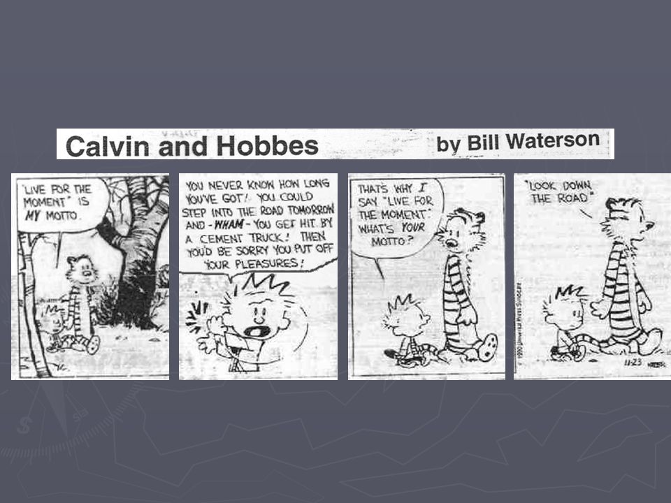
Decision-making process ► Identify Question ► Collect data / information about Question ► Summarize data ► Develop potential solutions ► Analyze and select solution ► Implement selected solution ► Reevaluate

4
Examples of decisions ► No-Till or Minimum tillage on a particular field ► Seed or plant variety ► Amount of fertilizer ► Participation in a government program ► Adding drainage tile/terraces/furrows ► Harvesting time ► Irrigation

5
3 Objectives of Precision Farming ► Recordkeeping Use of Precision farming tools to record inventory, production or management ► Spatial analysis Use of tools and records to analyze records for decision making ► Variable Rate Application Use of tools and analysis to apply correct amounts on fields

6
Decision-making ► A decision should be based on accurate and complete data. ► This data is summarized to create valuable information. ► Information is interpreted (explained) in order to make a decision.
 in order to make a decision..")
7
Tools of Precision Farming ► Global Positioning System ► Geographic Information System ► Computers ► Intelligent Devices and Implements ► Remote Sensing/Digital Imagery

8
How are the tools used? ► Data collection IDI sensors to measure and sense soils or conditions GPS to georeference to a map GIS to manage and display data ► Data Analysis Statistical Summary - GIS Query objects and areas of interest - GIS ► Implementation GIS Spatial records in database Interpretive maps from GIS Variable Rate Application with GPS and IDI

9
Processes of Precision Farming ► Data Collection (builds data) ► Data Analysis (creates information) ► Information Implementation (uses information for decision making) ► Duplicates the decision making process
 ► Data Analysis (creates information) ► Information Implementation (uses information for decision making) ► Duplicates the decision making process")
10
What does industry need? ► Graduates that have: Agronomic skills Technical skills Work ethics Geospatial skills Critical thinking

11
Tool vs Processes of Geospatial Technologies GPS and GIS are tools used for the processes ► Some programs and courses are designed to teach the tools without teaching the processes ► Teaching the tools is training, teaching the processes and critical thinking skills is education ► Based on what industry needs, we need to be concentrating on using geospatial tools to enhance critical thinking and work ethic skills

12
Techniques of Data Collection ► Field operations ► Scouting ► As applied variable rate application ► Remotely sensed images ► Yield mapping ► Soil testing If we are teaching these without helping the student apply it to a problem, then we are teaching tools.

13
Sampling techniques

14
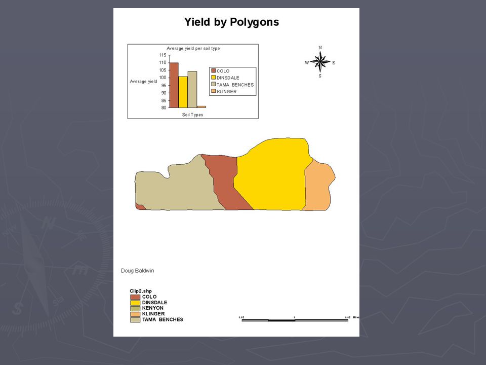
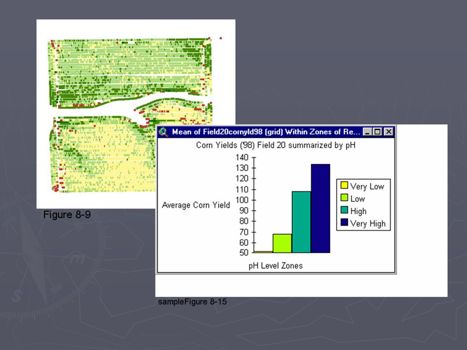
Techniques of Data Analysis ► Averaging and summarizing data ► Query selection and averaging data ► Creating Management Zones ► Surface analysis ► Reclassifying data ► Overlay analysis ► Statistical analysis

15
Surfacing techniques

16
Techniques of Interpretation and Implementation ► Suitability map ► Summarize by zones ► Temporal analysis map ► Predictive modeling ► Prescriptive modeling

19
Data collection ► In industry – managers need data and information to make decisions ► Collecting accurate and valid data ► Knowing what data to collect ► Spatial awareness!

20
Data Collection - Critical Thinking Activities Intro to Precision Farming Introduce the concept of data collection Students are assigned random objects and must think of attributes that could be collected as data and would be valuable for a person managing those objects Example – Students are assigned fireplugs and they must think of 3 attributes that could be recorded as data. Or trash receptacles, street lamps…

21
Geospatial Data Collection provides advanced techniques in collecting data Students must determine data that needs to be collected. Identify their own project (park, cornfield, golf course...) and the problem to be solved. Students must define the question, develop a list of attributes and data that they collect for their project Data Collection - Critical Thinking Activities
 and the problem to be solved. Students must define the question, develop a list of attributes and data that they collect for their project Data Collection - Critical Thinking Activities.")
22
► Outcomes from class – Students must: Build a project with data Create a final map of collected data Present contact with map and data

23
Data Analysis ► Data collected in the field must be analyzed to come up with usable information. ► A map that is easy to interpret and provides the information to assist in a decision

24
Data Analysis - Critical Thinking Activities ► Agricultural Spatial Analysis Develop the ability to create interpretative maps from which a decision can be made. Students are given an example of a technique – example, suitability map The process is demonstrated from question to answer Students then decide if the interpretative technique is appropriate for their problem Students must develop an example of an agriculturally related question that could be answered using a suitability map One question is selected and students are given the task of answering that question.

25
Answering the question ► Once the suitability map has been created, the student must provide an oral description (interpretation) of what it means and provide a recommendation for implementation or a decision. ► Student provides an interpretative map and presentation to contact Analysis skills Communication skills

26
Summary ► GPS and GIS are tools that can be used in almost any discipline ► GPS and GIS are cool and fun! ► Critical thinking skills can taught with GPS and GIS

27
107 Washington Hall Kirkwood CC 6301 Kirkwood Blvd Cedar Rapids, IA 52404 (866) 4AGKNOW www.agknow.org Terry Brase (319) 398-5458 tbrase@kirkwood.edu www.kirkwood.edu/faculty/tbrase
 4AGKNOW Terry Brase (319)")
Similar presentations


>")


 Presentation of Homework Assignment.>")


