Download presentation
Presentation is loading. Please wait.

1
Val Noronha University of California, Santa Barbara NCRST — Infrastructure Management

2
N C R S T Tri-states 2001-08-14 #2 What is NCRST Funded under TEA-21, 1998 US DOT: Research & Special Programs Administration Philosophy: rapid evolution of research into commercial products, practice User consultation and outreach Partnerships: industry, international

3
N C R S T Tri-states 2001-08-14 #3 Guiding Principles Rapid evolution of basic research to deployment Universities feed private sector: Technology Application Partners Universities engage in consultation and outreach

4
N C R S T Tri-states 2001-08-14 #4 Four NCRSTs Environment — Mississippi Infrastructure — California Flow — Ohio Hazards — New Mexico

5
N C R S T Tri-states 2001-08-14 #5 GPCI NM Fletcher Wisconsin Vonderohe Scarpace Adams Iowa Souleyrette Hallmark Andrle Florida Shrestha Degner Tuell California Goodchild Church [Estes] Roberts Manjunath Gerges Noronha Consortium Members
![N C R S T Tri-states #5 GPCI NM Fletcher Wisconsin Vonderohe Scarpace Adams Iowa Souleyrette Hallmark Andrle Florida Shrestha Degner Tuell California Goodchild Church [Estes] Roberts Manjunath Gerges Noronha Consortium Members](http://images.slideplayer.com/16/5163532/slides/slide_5.jpg "N C R S T Tri-states #5 GPCI NM Fletcher Wisconsin Vonderohe Scarpace Adams Iowa Souleyrette Hallmark Andrle Florida Shrestha Degner Tuell California Goodchild Church [Estes] Roberts Manjunath Gerges Noronha Consortium Members")
6
N C R S T Tri-states 2001-08-14 #6 Technology Application Partners OrbImage — Terry Lehman ASL TetraTech — Bill Lyte

7
N C R S T Tri-states 2001-08-14 #7 Steering Committee Advisor: Chris Lee Industry Earthdata — K Schuckman GDT — Don Cooke Intermap — Ron Birk Oracle — Xavier Lopez State DOTs CA — Diane Pierzinski IA — Ian MacGillivray Academic IN — Bill Black SC — John Jensen ITS Research JPL — Bob Barrett ITS T 2 — Linda Howe Feds FHWA — Roger Petzold USGS — Steve Guptill

8
N C R S T Tri-states 2001-08-14 #8 Outline Directions Research Projects MidWest DOT Directions

9
D I R E C T I O N S

10
N C R S T Tri-states 2001-08-14 #10 How to impact Infra Management? Information* on location and condition of infrastructure assets is critical to effective management *data processed into information products used in decision making

11
N C R S T Tri-states 2001-08-14 #11 Research Production Line Problem Sensor Image processing Data integration Decision/solution Data management Needs analysis Sensor technology Image processing tech Analysis/process model Education & outreach Data models, communication

12
R E S E A R C H P R O J E C T S

13
N C R S T Tri-states 2001-08-14 #13 DOT Priorities — 1 Accurate centerline maps consistently identified as a high priority, by photogrammetry and IT staff in DOTs Critical resource for ITS, EMS Highway management: integration of linear referenced archives with GPS

14
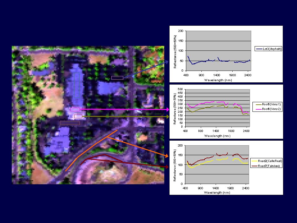
N C R S T Tri-states 2001-08-14 #14 Road Centerline Extraction Find pixels that represent road … hyperspectral library Detect linear patterns, form centerlines Attach legacy attributes Compare costs and benefits

15
Easy Street New neighborhood Little or no foliage overhang Vehicles in garage/driveway

16
Not so easy Repairs and surface coats Paint stripes Shadows Parked vehicles Foliage overhangs

19
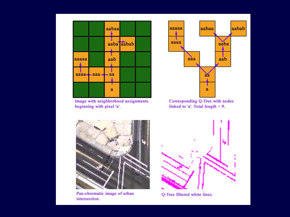
N C R S T Tri-states 2001-08-14 #19 3-step hyperspectral process MESMAQ-treeVectorize Additional steps: clean, revisit, conflate

20
N C R S T Tri-states 2001-08-14 #20 Original image 6-band, 28m pixels Road map from Q-tree filter Desert Context — Landsat7

21
N C R S T Tri-states 2001-08-14 #21 Other centerline methods RS is one of several components of the solution Alternate technologies for (x,y) GPS Cell phone multi-path tracking Emerging technologies in ITS ?
 GPS Cell phone multi-path tracking Emerging technologies in ITS")
22
N C R S T Tri-states 2001-08-14 #22 Error and Accuracy Acceptable accuracy: 1mm or 10m? Rural freeways vs urban intersections Present vs future applications

23
N C R S T Tri-states 2001-08-14 #23 GPS for Hwy Ops Hi end Lo end compatibility

24
N C R S T Tri-states 2001-08-14 #24 Low-end GPS units $250$195$150

25
N C R S T Tri-states 2001-08-14 #25 Lane Discrimination Test

26
N C R S T Tri-states 2001-08-14 #26 Lane Discrimination Test

27
N C R S T Tri-states 2001-08-14 #27 Lane Discrimination Test

28
N C R S T Tri-states 2001-08-14 #28 Lane Discrimination Test

29
N C R S T Tri-states 2001-08-14 #29 Lane Discrimination Test

30
N C R S T Tri-states 2001-08-14 #30 The one to beat … $150 at Staples Convenience Price Can RS beat this?

31
N C R S T Tri-states 2001-08-14 #31 Big Picture Global scale — Logistics Local scale, esp urban — Asset mgmt

32
N C R S T Tri-states 2001-08-14 #32

33
N C R S T Tri-states 2001-08-14 #33

34
N C R S T Tri-states 2001-08-14 #34 Validation Accuracy Turnaround time Cost Client response Developers’ response?

35
N C R S T Tri-states 2001-08-14 #35 © 1999 Val Noronha All rights reserved

36
N C R S T Tri-states 2001-08-14 #36

37
N C R S T Tri-states 2001-08-14 #37 Data Model unifies Centerlines

38
N C R S T Tri-states 2001-08-14 #38 DOT Priorities — 2 Program delivery is currently a high priority … require information to facilitate projects Integrated planning — construction costs, bridges, NIMBY, environment Large scale mapping surveys (1:500 to 1:5000)
")
39
N C R S T Tri-states 2001-08-14 #39 Corridor Analysis Alameda Corridor: rail line from port of Los Angeles and Long Beach to downtown Los Angeles

40
N C R S T Tri-states 2001-08-14 #40 Alameda Corridor Project Corridor analysis tool Rehabilitation of brown sites, redevelopment, facility siting Manage growth

41
N C R S T Tri-states 2001-08-14 #41 DOT Priorities — 3 FHWA mandate: National Bridge Inventory requires bridge locations within ± 2 m Wisconsin DOT request

42
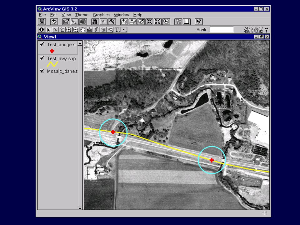
N C R S T Tri-states 2001-08-14 #42 Current Bridge Record

43
N C R S T Tri-states 2001-08-14 #43 Bridge Location Solution Overlay state DOT’s centerline on imagery of increasing resolution BridgeView — ArcView extension Adjust location manually Update table with missing bridges

45
N C R S T Tri-states 2001-08-14 #45 DOT Priorities — 4

46
N C R S T Tri-states 2001-08-14 #46 Pavement Condition Survey

47
N C R S T Tri-states 2001-08-14 #47 Road Surface Modification

48
N C R S T Tri-states 2001-08-14 #48 DOT Priorities — 5 Access & Safety $150b/yr crash loss 40% preventable by improving access 2-way left turn lanes Traffic control Pedestrian facilities

49
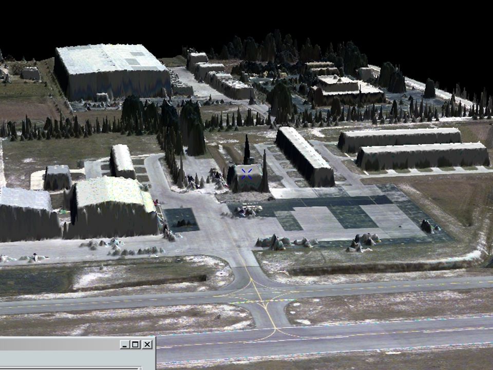
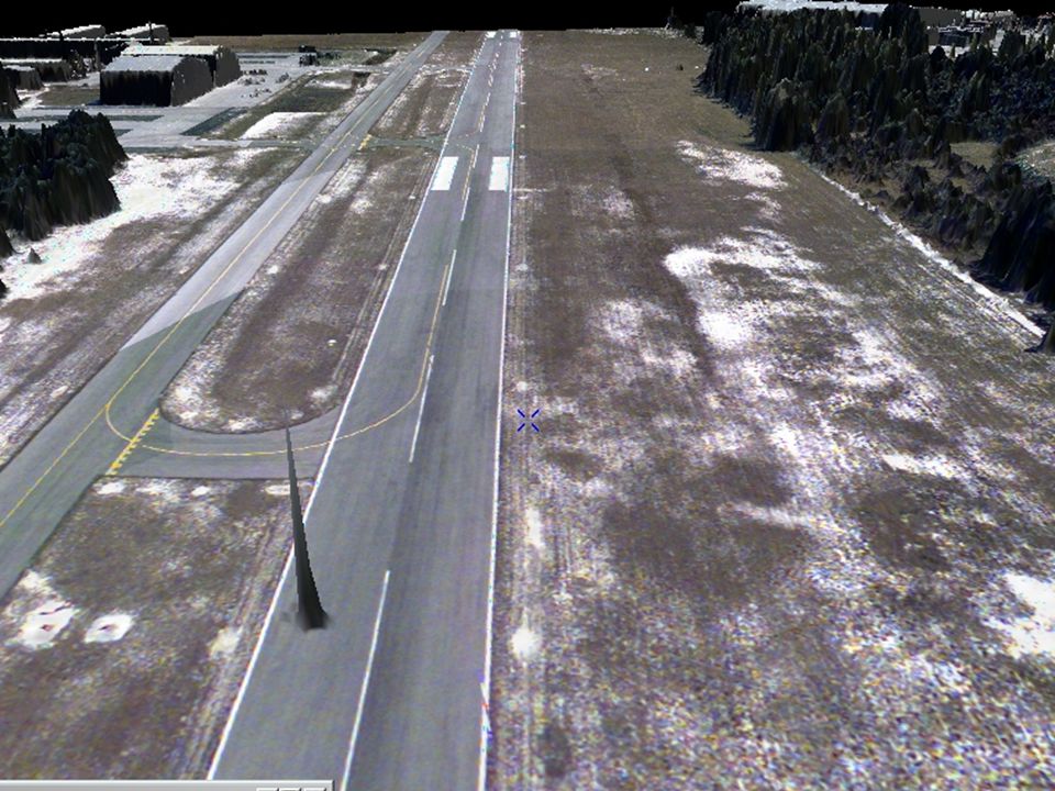
N C R S T Tri-states 2001-08-14 #49 3-D Applications LIDAR: ± 30 cm DEMs Uses 3-D Airport Approach Planning: FAA priority Planning a new corridor: saves 30% on map- survey effort Wireless tower location Hydrology Migration of coastlines

50
N C R S T Tri-states 2001-08-14 #50 3-D Airport Approach Planning

53
N C R S T Tri-states 2001-08-14 #53 DOT Priorities — 6 1/3 of California roads are not covered by police radio Fiber/5.9 GHz network coming GPS dropout areas Locate towers so as to minimize cost, maximize coverage

54
N C R S T Tri-states 2001-08-14 #54 Interfaces & Tools Facilitate manual change detection by image flicker — red and green

55
N C R S T Tri-states 2001-08-14 #55 Interfaces & Tools Facilitate manual change detection by splitting the viewer

56
N C R S T Tri-states 2001-08-14 #56 Synthesis Task Synthesis Report Web page Specialist meetings

57
N C R S T Tri-states 2001-08-14 #57 Entry points End points Application tree: e.g. highway — centerlines FAQ: focused questions Core curriculum: “tell me more about LIDAR” Matrix of user needs Glossary Bibliography Cookbooks Blurbs Professional Development by Web

58
N C R S T Tri-states 2001-08-14 #58 Events CLEM2001: CenterLine Extraction and Maintenance, specialist meeting, August 6-7, Santa Barbara TRB 2001 International workshop with Chinese University of HongKong, 2002

59
1

60
M I D W E S T D O T D I R E C T I O N S

61
N C R S T Tri-states 2001-08-14 #61 Directions Where are we now? Where do we want to go? How to get there? 2001 action plan Beyond 2001

Similar presentations