Download presentation
Presentation is loading. Please wait.

1
ARISTOTELION UNIVERSITY OF THESSALONIKI SCHOOL OF TECHNOLOGY FACULTY OF RURAL AND SURVEYING ENGINEERING DEPARTMENT OF TRANSPORTATION AND HYDRAULIC ENGINEERING TECHNICAL SECRETARIAT OF THE STEERING COMMITTEE GEOGRAPHIC INFORMATION SYSTEM OF THE PAN-EUROPEAN CORRIDOR X April 2002 Technical Secretariat Pan-European Transport Corridor X

2
The continuous and systematic monitoring of any procedure concerning, directly or indirectly, the development of Corridor X (Upgrading, rehabilitation, reconstruction). MAIN OBJECTIVE OF THE CORRIDOR X G.I.S. Monitoring and planning activities Integrated technology for analysis and spatial study that contributes to the decision making process Submission of integrated information Simulation and mapping of scenarios Solutions to complex problems Quick and easy map production Development of direct and effective solutions in an operational and economic way According to data quality: Quick and to the point decisions CHARACTERISTICS OF THE G.I.S. TECHNOLOGY

3
Sources of data used in data base: Questionnaire-based survey On-site visits – expertise Communication process between the Technical Secretariat and the responsible Authorities * The participants were supplied with the first version of the Data Base (in MS Excel format) during the 3 rd meeting of the S.C. and they replied within a month with comments on the information included in the Data Base. Internet Digital Background: Satisfactory level of accuracy for the scope of the T.S. activities Various analog and digital maps collected by the T.S. Two special features: International character of the application (collection, distribution and exchange of information) “Network” G.I.S.: linear reference unit applied to the study of the infrastructure of the rail and road sections of the Corridor APPLICATION OF G.I.S. TECHNOLOGY IN CORRIDOR X – SPECIAL FEATURES
 Network G.I.S.: linear reference unit applied to the study of the infrastructure of the rail and road sections of the Corridor APPLICATION OF G.I.S. TECHNOLOGY IN CORRIDOR X – SPECIAL FEATURES.")
4
Hardware Software D.B.M.S. Query tools Graphical User Interface People (Users) Methods of analysis Data Improved organization Integrated information Dynamic relation between spatial and descriptive data Analysis by non-experienced users Standardization of data base structure Easy updating and exchange of data COMPONENTS OF THE G.I.S. ADVANDAGES OF THE G.I.S.
 Methods of analysis Data Improved organization Integrated information Dynamic relation between spatial and descriptive data Analysis by non-experienced users Standardization of data base structure Easy updating and exchange of data COMPONENTS OF THE G.I.S. ADVANDAGES OF THE G.I.S..")
5
DATA MANAGEMENT CONSIDERATIONS Not very large data volume (at present) Use of a Data Base Management System (D.B.M.S.): Storing, retrieval, management of all kind of data, including spatial. An increase of data volume is expected due to the need for: progress reports, possibly a new questionnaire survey, and flows data Relational (storing as a set of tables) Entity – Relation Diagrams Road Data Base Rail Data Base
 Entity – Relation Diagrams Road Data Base Rail Data Base.")
8
FORMS IN CORRIDOR X ROAD DATA BASE

9
FORMS IN CORRIDOR X RAIL DATA BASE Website Maps

10
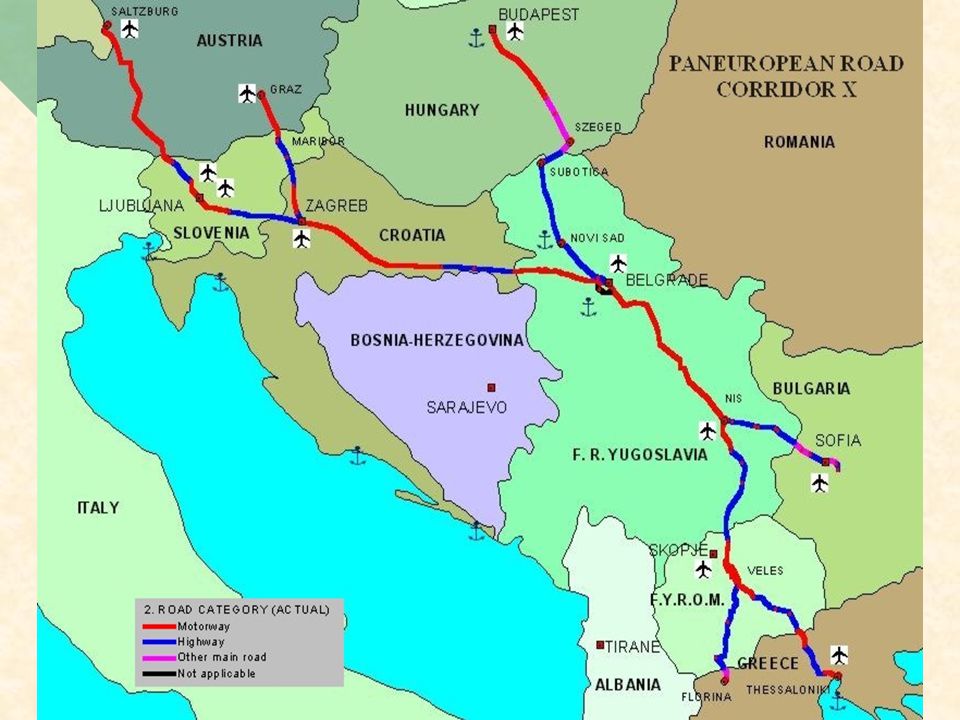
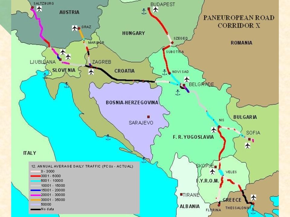
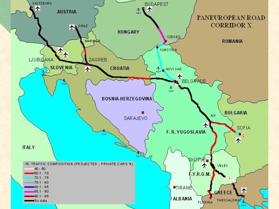
TABLE OF CONTENTS OF ROAD G.I.S. (1/2) Status of road Corridor X Status of road Corridor X Road category (actual) Road category (actual) Road category (projected) Road category (projected) Traffic lanes per direction (actual) Traffic lanes per direction (actual) Traffic lanes per direction (projected) Traffic lanes per direction (projected) Horizontal alignment (actual) Horizontal alignment (actual) Horizontal alignment (projected) Horizontal alignment (projected) Road capacity (actual) Road capacity (actual) Road capacity (projected) Road capacity (projected) Annual Average Daily Traffic (actual) Annual Average Daily Traffic (actual) Annual Average Daily Traffic (projected) Annual Average Daily Traffic (projected) Traffic composition (actual) Traffic composition (actual) Traffic composition (projected) Traffic composition (projected) Maximum design speed (actual) Maximum design speed (actual) Maximum design speed (projected) Maximum design speed (projected) Accidents per kilometer Accidents per kilometer Traffic flows at cross borders (private and commercial vehicles) Traffic flows at cross borders (private and commercial vehicles) Mean estimated delays at cross borders for private and commercial vehicles Mean estimated delays at cross borders for private and commercial vehicles
 Status of road Corridor X Status of road Corridor X Road category (actual) Road category (actual) Road category (projected) Road category (projected) Traffic lanes per direction (actual) Traffic lanes per direction (actual) Traffic lanes per direction (projected) Traffic lanes per direction (projected) Horizontal alignment (actual) Horizontal alignment (actual) Horizontal alignment (projected) Horizontal alignment (projected) Road capacity (actual) Road capacity (actual) Road capacity (projected) Road capacity (projected) Annual Average Daily Traffic (actual) Annual Average Daily Traffic (actual) Annual Average Daily Traffic (projected) Annual Average Daily Traffic (projected) Traffic composition (actual) Traffic composition (actual) Traffic composition (projected) Traffic composition (projected) Maximum design speed (actual) Maximum design speed (actual) Maximum design speed (projected) Maximum design speed (projected) Accidents per kilometer Accidents per kilometer Traffic flows at cross borders (private and commercial vehicles) Traffic flows at cross borders (private and commercial vehicles) Mean estimated delays at cross borders for private and commercial vehicles Mean estimated delays at cross borders for private and commercial vehicles.")
11
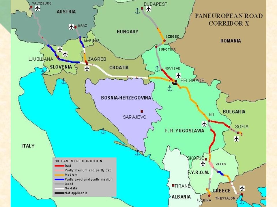
TABLE OF CONTENTS OF ROAD G.I.S. (2/2) Pavement condition Pavement condition Land type Land type Level of signing Level of signing Level of lighting Level of lighting Parking areas Parking areas Tolls stations Tolls stations
 Pavement condition Pavement condition Land type Land type Level of signing Level of signing Level of lighting Level of lighting Parking areas Parking areas Tolls stations Tolls stations.")
39
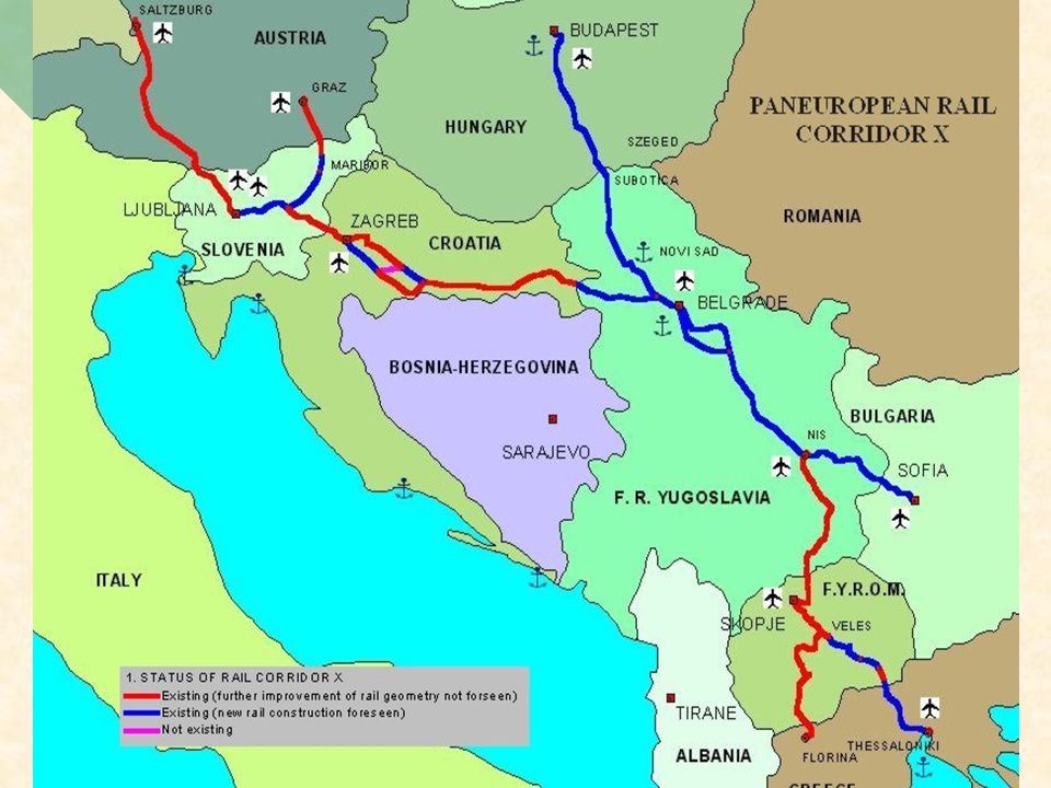
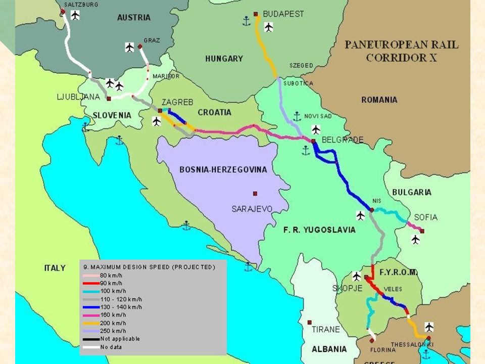
TABLE OF CONTENTS OF RAIL G.I.S. (1/2) Status of rail Corridor X Status of rail Corridor X Traction system (actual) Traction system (actual) Traction system (projected) Traction system (projected) Track alignment - single or double track (actual) Track alignment - single or double track (actual) Track alignment - single or double track (projected) Track alignment - single or double track (projected) Freight trains commercial speed Freight trains commercial speed Passenger trains commercial speed Passenger trains commercial speed Running time for international passenger trains (actual) Running time for international passenger trains (actual) Running time for international passenger trains (projected) Running time for international passenger trains (projected) Running time for international freight trains (actual) Running time for international freight trains (actual) Running time for international freight trains (projected) Running time for international freight trains (projected) Passenger trains per day (actual) Passenger trains per day (actual) Passenger trains per day (projected) Passenger trains per day (projected) Freight trains per day (actual) Freight trains per day (actual) Freight trains per day (projected) Freight trains per day (projected) Annual freight carried (actual) Annual freight carried (actual) Annual freight carried (projected) Annual freight carried (projected) Annual number of passengers (actual) Annual number of passengers (actual) Annual number of passengers (projected) Annual number of passengers (projected)
 Status of rail Corridor X Status of rail Corridor X Traction system (actual) Traction system (actual) Traction system (projected) Traction system (projected) Track alignment - single or double track (actual) Track alignment - single or double track (actual) Track alignment - single or double track (projected) Track alignment - single or double track (projected) Freight trains commercial speed Freight trains commercial speed Passenger trains commercial speed Passenger trains commercial speed Running time for international passenger trains (actual) Running time for international passenger trains (actual) Running time for international passenger trains (projected) Running time for international passenger trains (projected) Running time for international freight trains (actual) Running time for international freight trains (actual) Running time for international freight trains (projected) Running time for international freight trains (projected) Passenger trains per day (actual) Passenger trains per day (actual) Passenger trains per day (projected) Passenger trains per day (projected) Freight trains per day (actual) Freight trains per day (actual) Freight trains per day (projected) Freight trains per day (projected) Annual freight carried (actual) Annual freight carried (actual) Annual freight carried (projected) Annual freight carried (projected) Annual number of passengers (actual) Annual number of passengers (actual) Annual number of passengers (projected) Annual number of passengers (projected).")
40
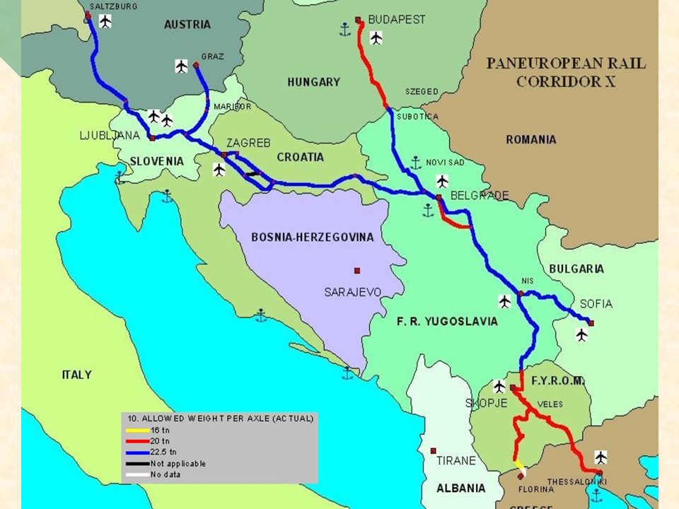
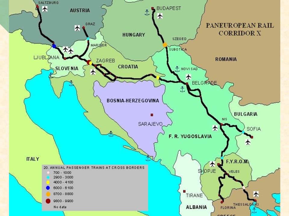
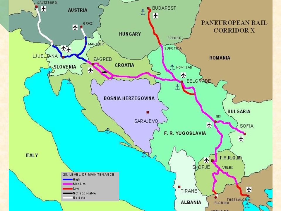
TABLE OF CONTENTS OF RAIL G.I.S. (2/2) Capacity (actual) Capacity (actual) Capacity (projected) Capacity (projected) Maximum design speed (actual) Maximum design speed (actual) Maximum design speed (projected) Maximum design speed (projected) Allowed weight per axle (actual) Allowed weight per axle (actual) Allowed weight per axle (projected) Allowed weight per axle (projected) Accidents per kilometer Accidents per kilometer Annual passenger trains at cross borders Annual passenger trains at cross borders Annual freight trains at cross borders Annual freight trains at cross borders Mean estimated delays at cross borders for passenger and freight trains Mean estimated delays at cross borders for passenger and freight trains Level of maintenance Level of maintenance Land type Land type Signaling system (actual) Signaling system (actual) Signaling system (projected) Signaling system (projected) Number of at level crossings (actual) Number of at level crossings (actual) Number of at level crossings (projected) Number of at level crossings (projected)
 Capacity (actual) Capacity (actual) Capacity (projected) Capacity (projected) Maximum design speed (actual) Maximum design speed (actual) Maximum design speed (projected) Maximum design speed (projected) Allowed weight per axle (actual) Allowed weight per axle (actual) Allowed weight per axle (projected) Allowed weight per axle (projected) Accidents per kilometer Accidents per kilometer Annual passenger trains at cross borders Annual passenger trains at cross borders Annual freight trains at cross borders Annual freight trains at cross borders Mean estimated delays at cross borders for passenger and freight trains Mean estimated delays at cross borders for passenger and freight trains Level of maintenance Level of maintenance Land type Land type Signaling system (actual) Signaling system (actual) Signaling system (projected) Signaling system (projected) Number of at level crossings (actual) Number of at level crossings (actual) Number of at level crossings (projected) Number of at level crossings (projected).")
Similar presentations


 based “Decision Support System for Transport”>")


