Download presentation
Presentation is loading. Please wait.

1
Lecture 14 Tropical disturbances, tropical depressions, tropical cyclones Other tropical systems, remember the ITCZ

2
Tropical cyclones What are they? How are they structured? How and where do they form? What is the life cycle? Tropical cyclone tracks How do they cause destruction? Observing and forecasting them

3
Hurricane Mitch approaching Honduras on Oct. 26, 1998 5-6 Atlantic, 9 in E Pacific, 16 W Pacific

4
Hurricane Mitch in W Caribbean Oct 26 IR images

5
Structure The eye, clear of clouds (8 km or more) eye wall: narrow circular rotating region of intense thunderstorms Spiral rain bands Depend on warm water, warm air. Up moist, down dry.

6
Cross-section of a hurricane (vertical dimension exaggerated)
")
7
Large weather engines Driven by latent heat of water Air of tropics dry because of subsidence in the subtropics and trade winds blowing that air equatorw. Evaporation may take place and great amounts of energy are collected that may be released when the water vapor condenses into liquid water again. Air is driven into the center because there the pressure is lowest. Tight pressure gradient, wind speed is increasing toward the eye; even more energy in latent form

8
How strong a heat engine? “The energy released by condensation in a single day in an average hurricane is at least 200 times the entire world’s electrical energy production capacity.” Can calculate the minimum possible central sea-level pressure for a tropical cyclone based on SSTs

9
Minimum possible central pressure for a perfect tropical cyclone, avg Sept SST

10
Regions where most hurricanes form

11
What inhibits tropical cyclone development if SSTs are above 26.5C? Location too close to the equator because of the decreasing Coriolis effect and therefore less spin Vertical shear. It tends to tear apart the vertical structure in the storm

12
Hurricane Celia wind measurements

13
Winds are strongest on the NE side of the storm because of its movement

14
Wind damage from hurricane

15
What is the life cycle? Easterly waves, westward propagating disturbances (WPDs) Tropical depression, tropical cyclone hurricane/typhoon/cyclone of category –1 33-42 m/s –2 43-49 m/s –3 50-58 m/s –4 59-69 m/s –5 above 70 m/s Decay
 Tropical depression, tropical cyclone hurricane/typhoon/cyclone of category – m/s – m/s – m/s – m/s –5 above 70 m/s Decay.")
16
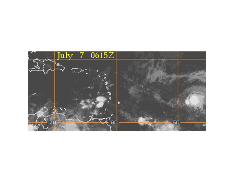
Vis satellite picture on 8/14/2001, easterly wave and a tropical depression are evident Tropical depression later became tropical storm Chantal

17
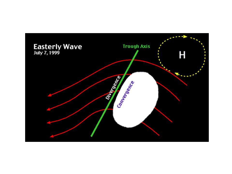
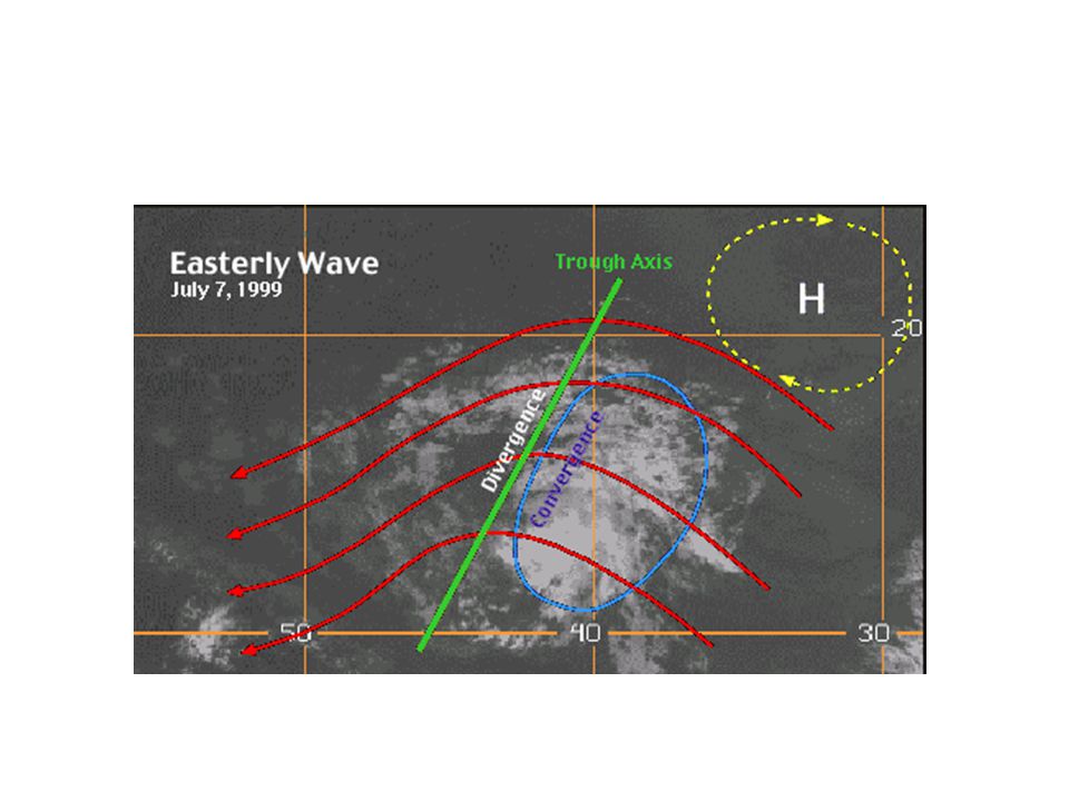
Easterly wave (scale 2000-3000 km)
")
18
Georges at different stages in its life cycle (IR satellite images) 18-28 Sept 98
 Sept 98")
19
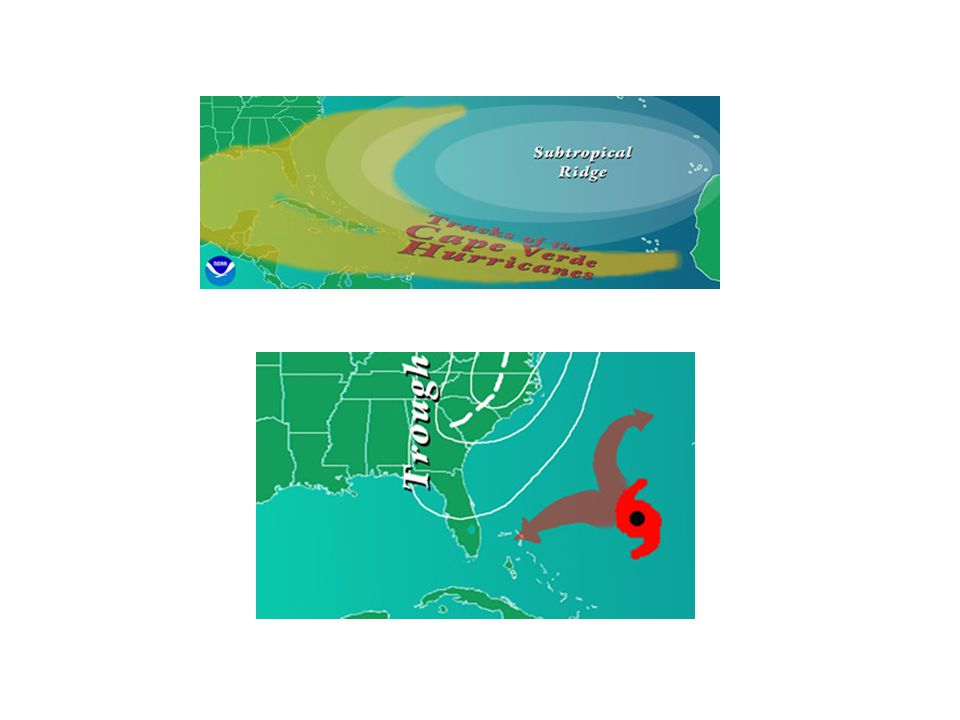
Hurricane Floyd’s track and SST Sept 99

20
Hurricane Allen ‘80

21
Category 5 storm that loses its powers when traveling over land.

22
After landfall

24
Tracks Determined by the vertically averaged background flow Under influence of subtropical highs It is also influenced by the perturbation the storm creates on the background vorticity gradient Additional ingradients still to be determined

25
The names, dates and stages of tropical storms in the Atlantic in 95

26
Two very damaging hurricane tracks

27
Weather Phenomena of the tropics Easterly waves Tropical disturbances, tropical depressions, tropical storms Tropical upper tropospheric troughs (TUTTs) Intertropical convergence zones (ITCZs) Kelvin, Mixed-Rossby gravity (MRG), inertio-gravity waves Madden Julian Oscillation (MJO)
 Intertropical convergence zones (ITCZs) Kelvin, Mixed-Rossby gravity (MRG), inertio-gravity waves Madden Julian Oscillation (MJO)")
28
African Easterly Waves form due to the instability of the African Easterly jet. Period of 3-4 days, wavelength of 2000-2500 km

29
Easterly Waves

34
How do tropical cyclones form? Note first baroclinic mode structure, warm ocean, low wind shear, moisture

35
How do tropical cyclones form ? (necessary but not sufficient conditions) Warm ocean (at least 50m deep) Potentially unstable atmosphere to moist convection Relatively moist layers near mid-troposphere (5 km) At least 500 km from equator (~5 deg latitude) Pre-existing near surface disturbance (vorticity) Low vertical wind shear (<10m/s from low to upper) –Sometimes the pre-existing disturbance is an MCC –Within envelope of the MJO –From breakdown of ITCZ
 Warm ocean (at least 50m deep) Potentially unstable atmosphere to moist convection Relatively moist layers near mid-troposphere (5 km) At least 500 km from equator (~5 deg latitude) Pre-existing near surface disturbance (vorticity) Low vertical wind shear (<10m/s from low to upper) –Sometimes the pre-existing disturbance is an MCC –Within envelope of the MJO –From breakdown of ITCZ.")
36
Sfc pressure vs wind speed for tropical systems. Hurricanes, p 118km/hr

37
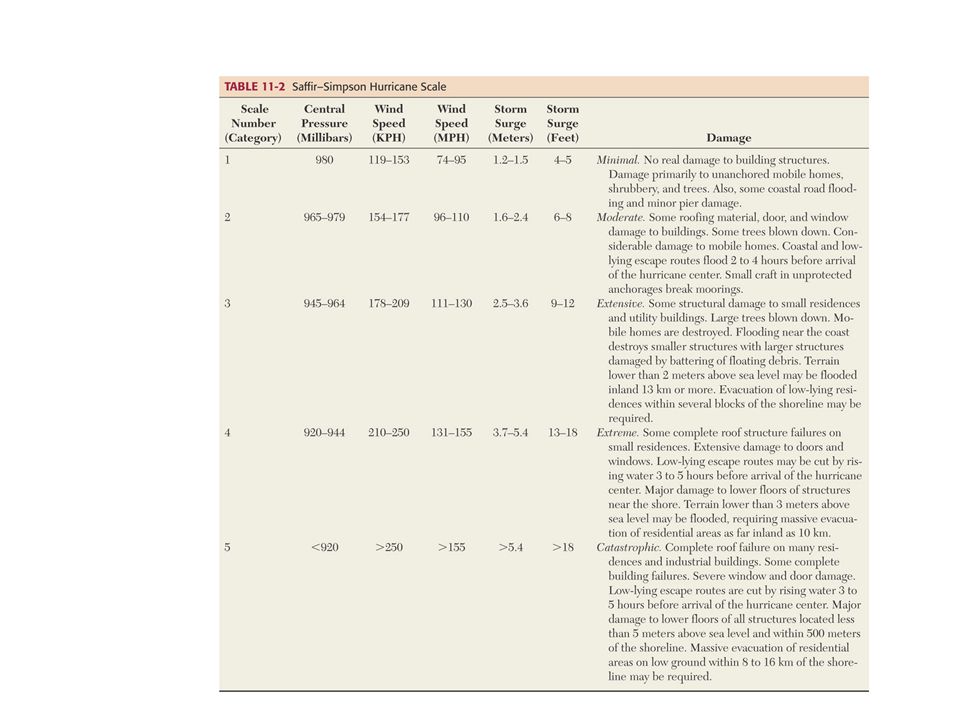
Table 7u-1: Saffir-Simpson scale of hurricane intensity. Type Category Pressure (mb) Winds (mph) Winds (kmph) Surge (meters) Tropical Depression TD-----< 39< 62----- Tropical Storm TS-----39-7363-118----- Hurricane1> 98074-95119-1531.2-1.5 Hurricane2965-98096-110154-1771.6-2.4 Hurricane3945-965111-130178-2092.5-3.6 Hurricane4920-945131-155210-2503.7-5.4 Hurricane5< 920>155>250>5.4
 Winds (mph) Winds (kmph) Surge (meters) Tropical Depression TD-----< 39< Tropical Storm TS Hurricane1> Hurricane Hurricane Hurricane Hurricane5< 920>155>250>5.4.")
38
A “typical” tropical cyclone measures about 600 to 800 km horizontally and extends 15 km vertically

39
Energy Latent energy, gained through evaporation, drives tropical cyclones. Within the storm, this energy is efficiently converted to mechanical energy reinforcing the storm's pressure gradient and winds. The process depends on unsaturated air slowly sinking from the upper atmosphere at the periphery of the storm and gaining moisture (latent heat) as it moves over the ocean surface and towards the eye wall.
 as it moves over the ocean surface and towards the eye wall..")
40
Hurricane Hortense (1996) note the spiral structure
 note the spiral structure")
41
How much energy does a hurricane release? - Total energy released through cloud/rain formation: An average hurricane produces 1.5 cm/day (0.6 inches/day) of rain inside a circle of radius 665 km (360 n.mi) (Gray 1981). (More rain falls in the inner portion of hurricane around the eyewall, less in the outer rainbands.) Converting this to a volume of rain gives 2.1 x 10^16 cm3/day. A cubic cm of rain weighs 1 gm. Using the latent heat of condensation, this amount of rain produced gives 5.2 x 10^19 Joules/day or 6.0 x 10^14 Watts. This is equivalent to 200 times the world-wide electrical generating capacity - an incredible amount of energy produced!
 of rain inside a circle of radius 665 km (360 n.mi) (Gray 1981). (More rain falls in the inner portion of hurricane around the eyewall, less in the outer rainbands.) Converting this to a volume of rain gives 2.1 x 10^16 cm3/day. A cubic cm of rain weighs 1 gm. Using the latent heat of condensation, this amount of rain produced gives 5.2 x 10^19 Joules/day or 6.0 x 10^14 Watts. This is equivalent to 200 times the world-wide electrical generating capacity - an incredible amount of energy produced!.")
42
Energy Notice the 1:400 ratio, KE of the hurricane : LH used Very inefficient heat engine

43
Tropical cyclone tracks and geography T ropical cyclones are steered by the background flow throughout the depth of the troposphere (eestward with slight poleward component) Depends on strength of subtropical ridge May take a more northward component and then recurve eastward if ridge is weak However, a tropical cyclone will modify the background flow and as in so many other cases, there is not clear cut way of teasing the two apart. Beta effect A difficult forecast problem

45
Multiple storm tracks

46
Typical areas where hurricanes begin their path and typical early paths

47
Locations where hurricanes began their development (1950-2000)
")
48
Color coded tropical storm tracks

Similar presentations


 Uneven solar energy inputs 2) Rotation of the Earth Global Circulation Patterns Local Events.>")


 Topic 8: Storm Systems Chris Parkes Rm 455 Kelvin Building.>")
 and the Tropic of Capricorn (23.5S) The weather is very different.>")


 Tropical Cyclones (anywhere) Cyclones (Indian Ocean + others) Hurricanes (near N. America) 4/22/03.>")
