Download presentation
Presentation is loading. Please wait.

1
Late Classic Maya Collapse
A.D

2
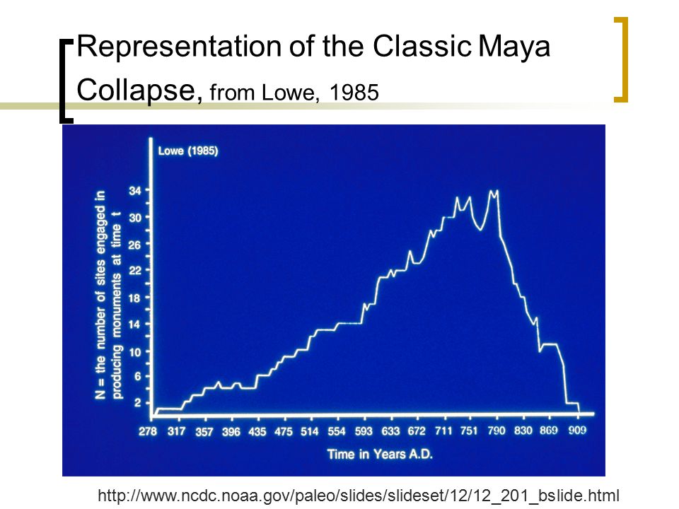
“Collapse” Most impressive buildings date to Terminal Classic
Major construction virtually ceased after 810 A. D. last date at Yaxchilan between AD Bonampak AD 800 Copan shortly after AD 800

3
Representation of the Classic Maya Collapse, from Lowe, 1985
4
Events slowdown in construction and erection of monuments
lack of hieroglyphic texts long-distance trade contacts ended

5
Characteristics “Collapse" may be a poor term
Failure more complete in core than in periphery Decline most profound at Tikal population at Tikal only one-tenth of pre-AD 800 size populations appear to continue in vicinity of Late Peten-Itza increase of activity in northern Lowlands Population centers abandoned

6
Reasons: internal factors
natural disasters Earthquakes:evidence at Xunantunich and Quirigua hurricanes Epidemics/disease yellow fever presence in monkeys suggests it may be indigenous skeletal evidence from Tikal and Altar suggest nutritional decline

7
Internal Factors, con’d
ecological disasters decline in soil fertility over exploitation failure of swidden agriculture failure of productivity of grasslands

8
Documenting Climate Change
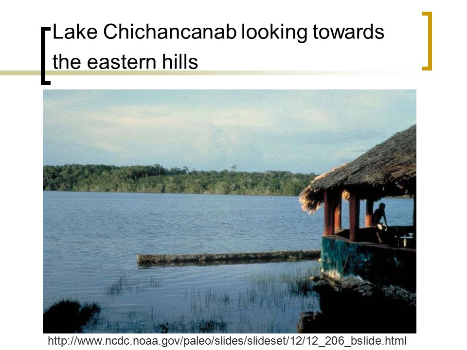
One area of study, Lake Chichancanab, is located in the center of the Yucatan. Lake Chichancanab is a long (26-km), narrow (2 km) lake, consisting of a series of basins that are connected during high water level. Sediment cores were collected from the central basin in a water depth of 6.9 m.
, narrow (2 km) lake, consisting of a series of basins that are connected during high water level. Sediment cores were collected from the central basin in a water depth of 6.9 m.")
9
Lake Chichancanab looking towards the eastern hills
10
Other study sites Lake Punta Laguna, located in the northeastern part of the Yucatan Peninsula about 20 km N-NE of Coba, a major Mayan archaeological site. Punta Laguna consists of three interconnected basins, each with a maximum depth of about 20-m. The coring site was located in the far basin in a water depth of about 6.3-m.

11
Lake Punta Laguna located in the northeastern section of the Yucatan Peninsula

12
Illustration of using lakes to determine climate change
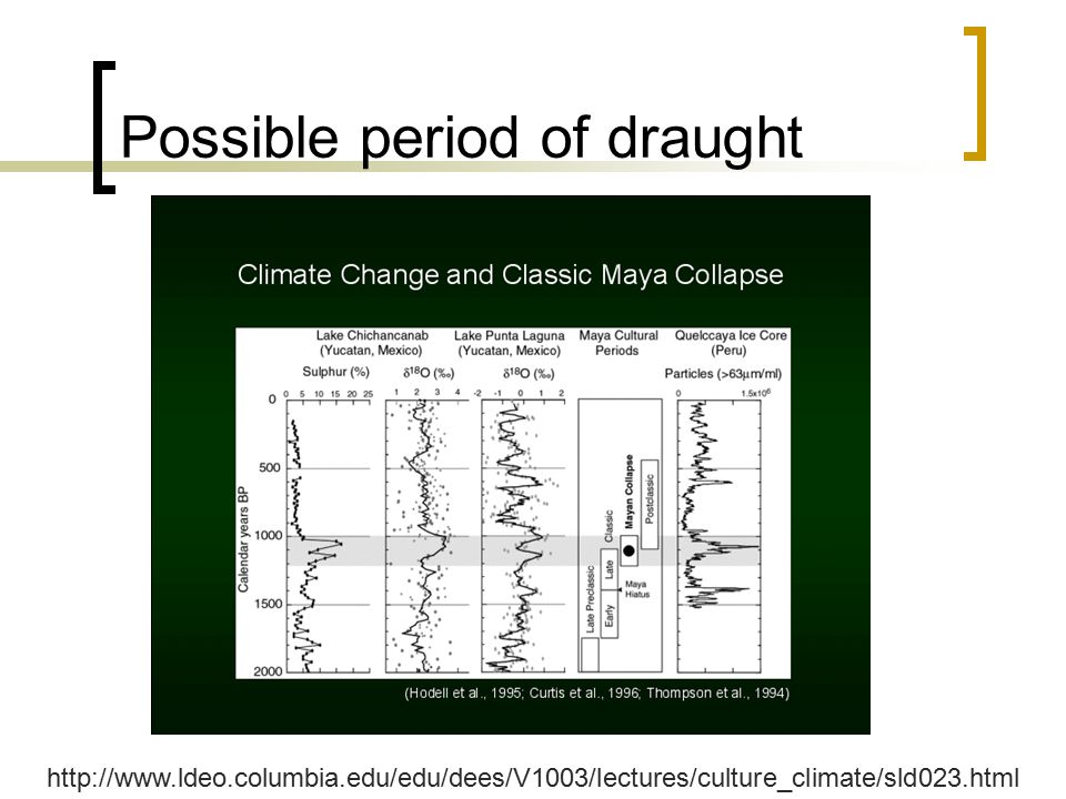
This illustration shows the simple working assumptions for interpreting changes in the sediment record in terms of climate (evaporation/precipitation). Top: Under conditions of wet climate (low E/P), we expect high lake levels, dilute concentrations of solutes, low 18O to 16Oratios in lake water and aquatic shells, and sediments consisting of mainly organic carbon and calcite. Middle: Under conditions of drier climate (moderate E/P), we expect lower lake levels, higher concentrations of dissolved solutes, higher ratios of 18O and 16O, and perhaps sediments dominated by calcite. Bottom: Under arid climate conditions (high E/P), we expect low lake levels (perhaps desiccation), high dissolved solute concentrations, high ratios of 18O and 16O and, in the case of Lake Chichancanab, sediments dominated by gypsum (CaSO4).
. Top: Under conditions of wet climate (low E/P), we expect high lake levels, dilute concentrations of solutes, low 18O to 16Oratios in lake water and aquatic shells, and sediments consisting of mainly organic carbon and calcite. Middle: Under conditions of drier climate (moderate E/P), we expect lower lake levels, higher concentrations of dissolved solutes, higher ratios of 18O and 16O, and perhaps sediments dominated by calcite. Bottom: Under arid climate conditions (high E/P), we expect low lake levels (perhaps desiccation), high dissolved solute concentrations, high ratios of 18O and 16O and, in the case of Lake Chichancanab, sediments dominated by gypsum (CaSO4).")
13
Possible period of draught
14
Other Internal Factors
Social disasters popular revolt, suggested by Thompson evidence and Piedras Negras of broken thrones increased differences between elite and non-elite classes rupture in trade i.e. rise of trading centers on peripheries led to collapse of core competition from Mexican states traditional ruling elite could not or would not improve competitive efficiency notions of cyclical history fatalistic associations with Katun 11 Ahau may have been exacerbated by distance between social classes civil warfare attempts by one center at consolidation most scholars interpret depictions as small-scale warfare and capture

15
Reasons: External Factors
Foreign invasion iconographic evidence from Seibal identified as Putun Maya, people from Gulf Coast rose to great power in Postclassic period may have become mercantile center with Altar eventually abandoned lack of evidence elsewhere suggests invasion may have been more of an effect than cause of collapse change in trade patterns suggests Late Classic Maya may have been isolated Putun Maya were seacoast traders demise of Tikal canoe routes so busy in Early Classic superceded by ocean-going routes around Yucatan withdrawal of Teotihuacan interaction may have caused Middle Classic hiatus

16
Evidence: Copan Two skulls from Copan showing anemia.
The skull on the right is from an elite individual.

17
Copan One side of this altar was completed, but the other sides were left unfinished. On one of these unfinished sides, the Maya text shows a date, equivalent to February 10, A.D The remaining text was never finished. There are no known monuments at Copán dated after A.D. 822.

18
Copan This slide is of mahogany pollen, dating to around A.D It shows that the Copán Valley had largely returned to forest by that time. Before A.D , there is little evidence of mahogany pollen in the sample. Mahogany pollen would be present in areas of tall forest, but not in areas of heavy farming.

19
Copan: Erosion Some Copán houses found near hillsides show debris from erosion. The probable cause of this erosion is that people were overfarming the hillsides. The erosion seems to have begun in the mid-eighth century and to have continued for a long time afterward. At some point, these houses were abandoned. Eventually, some houses were completely buried by erosion debris.

20
Copan: Obsidian manufacture
Obsidian blades found in Copán households show a range of dates, from A.D. 500 to 1200. After A.D , the number of blades drops off.

21
Collapse at Copan? Decline may be better term.
Based on the evidence found at Copán, this team of archaeologists concluded that overpopulation was a major contributor to collapse. A very large number of people lived in the Copán Valley, and so more and more of the land was farmed, just as it is today. This caused environmental stresses, such as erosion and crop shortages. These in turn caused malnutrition and disease, which were clear from the anemia shown in the skulls—even the skulls of the noble classes. From the obsidian dates and the pollen sample, the archaeologists concluded that the end of Copán was gradual, at least in the countryside. Though no monuments were built after A.D. 822, the population in the valley did not drop off seriously until about A.D Significant farming continued in the area until A.D After , the Copán Valley returned to forest, this previous center of Maya life abandoned by all but a few remaining farmers.

22
Lamanai Anomaly, because it continued beyond the Classic period.
Lamanai, or "submerged crocodile," began around 1500 B.C.

23
Lamanai, con’d Located adjacent to the New River lagoon, Lamanai's main structures and excavated artifacts exhibit many representations of the crocodile. Some of Lamanai's ruins are some of the oldest in Belize dating back to 700 B.C., Yet, of the 700 buildings within the complex, less than five percent have been excavated and explored. Aside from the central pyramid, thick forest has consumed many of the limestone mounds that housed the thousands of Mayan inhabitants. With a population exceeding 35,000 at the height of the city's power, Lamanai's trading influence extended over the borders of present-day Guatamala, Honduras, Mexico, and Belize.

24
Lamanai New River Lagoon

25
Reconstructed Main Temple

26
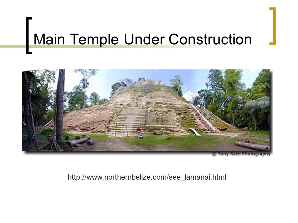
Main Temple Under Construction
27
Lamanai ball court

28
Lamanai

29
Lamanai temple with mask

30
Lamanai Mask

31
Lamanai Stela 9

32
Lamanai Crocodile

33
Goodbye Lamanai

34
So, why did the Classic Maya Collapse/Decline??
Does one reason fit all? Do several reasons fit all? Different reasons for different sites?

Similar presentations

>")


>")

.>")


 – rain forests & dry scrub Highlands.>")

 Access online textbook Maya/Aztec lecture Finish book notes (if needed) – pages.>")