Download presentation
Presentation is loading. Please wait.

1
Ocean Modeling Capabilities: Plans for Storm Surge and wave Modeling Research National Weather Service D.B. Rao NCEP Environmental Modeling Center August, 2005

3
Five Fundamental Operational Ocean Forecast Problems for NOAA 1. Global ocean on seasonal time scale 2. Daily Global Ocean State 3. Basin Scale Ocean State-Support for coastal ocean modeling (shelf, bays, estuaries) 4. Hurricanes and Extratropical Storm impacts 5. Global ocean for climate change time scale
 4. Hurricanes and Extratropical Storm impacts 5. Global ocean for climate change time scale.")
4
The Environmental Forecast Process Observations Analysis Model Forecast Post-processed Model Data Forecaster User (public, industry…) Numerical Forecast System Data Assimilation
 Numerical Forecast System Data Assimilation")
5
Real-time Daily Forecasts Use ocean models to provide operational forecasts, analyses and observations to users –Provide routine ocean state products on relevant time and space scales –Quality controlled, uniformly formatted ocean observations Use ocean models coupled to atmosphere to improve environmental forecast systems

6
Ocean Forecast Users Tropical Prediction Center. Ocean Prediction Center Marine Focal Points at National Weather Service (NWS) Field Forecast Offices. National Ocean Service (NOS). National Marine Fisheries Service (NMFS). Regional Ocean Forecast Centers. Research Community. Coastal Guard (toxic spills, search & rescue). Shipping and boating. Recreational Community.
 Field Forecast Offices. National Ocean Service (NOS). National Marine Fisheries Service (NMFS). Regional Ocean Forecast Centers. Research Community. Coastal Guard (toxic spills, search & rescue). Shipping and boating. Recreational Community..")
7
Current operational Ocean State Products Wave Modeling –Global and Regional –Unified model approach –NOAA Wavewatch III Sea Surface Temperature & Winds –NCEP Ocean Prediction Center support Gulfstream analysis & forecast Real-time Sea Ice products Regional (Coastal) Ocean Model
 Ocean Model")
8
MMAB Ice Products Present 25.4 km Resolution Near Future 12.7 km Resolution Future Concentration Model Ice Thickness Model Sea Ice Concentration

9
Operational Wave Models The operational wave model at NCEP is NOAA WAVEWATCH III, that is, the generic WAVEWATCH III model with GFS forcing (+ GFDL forcing for hurricanes). –Global 1.25 x1 model, and regional 0.25 models. –Intermediate water depth physics (i.e., outside surf zone). Adding new surf zone physics relatively simple. Not yet implemented based on spatial resolution. –Fixed water level, no currents. Wave model ready for unsteady water levels and currents. Waiting for reliable operational model input. 1
. Adding new surf zone physics relatively simple. Not yet implemented based on spatial resolution. –Fixed water level, no currents. Wave model ready for unsteady water levels and currents. Waiting for reliable operational model input. 1.")
10
NCEP/MMAB Wave Products - Global and regional models for Alaskan Waters and Western North Atlantic and Eastern Pacific with up to 168 h forecasts, 4 times daily - Hurricane wave model combining global and GFDL model winds (Atlantic & East Pacific) - NOAA Wavewatch III operational at FNMOC - Recent NWW3 upgrades Propagation Sub-grid islands - Next NWW3 upgrade Data assimilation (improves 0-12 h forecasts)
 - NOAA Wavewatch III operational at FNMOC - Recent NWW3 upgrades Propagation Sub-grid islands - Next NWW3 upgrade Data assimilation (improves 0-12 h forecasts)")
11
Operational Models 2 Alaska Waters regional model, approximate resolution 25 km. Aleutian Islands modeled as sub- grid obstacles.

12
Multi-scale model Deep ocean model resolution dictated by GFS model Higher coastal model resolution dictated by model economy Highest model resolution in areas of special interest Hurricane nests moving with storm(s) like GFDL and WRF
 like GFDL and WRF")
13
The Future The multi-scale wave model will feature two-way nesting, and moving nests for hurricanes. Coastal resolutions for Alaskan Waters of 2 to 5km are feasible with this technology, both for climatological and operational models. Such models will need surf-zone physics due to typical coastal water depths. 2

14
The Future -The model will be suitable for coupling with surge, inundation and morphology models. –Model architecture. –In input and output parameters for coupling. -The multi-scale model with static nests is expected to be available in mid 2006.

15
Climatology North American Regional Reanalysis (NARR) winds available –32km, 3h resolution. –1979 – 2003 –Covers Alaskan waters. Can be combined with global NCEP/UCAR reanalysis as needed. Can be used as the basis for a 24 year wave hindcast. –Climatology based on full spectral data, not on representative waves only. 1

16
Climatology Several modeling approaches available: –Traditional WAVEWATCH III approach with one-way nesting. –WAVEWATCH III + nested SWAN model for “arbitrary” resolutions and appropriate shallow water physics (may be combined with surge model). –New multi-scale WAVEWATCH III with or without SWAN nests. 2 Example of high-resolution bathymetry for Humbolt Bay entrance. Nested SWAN application for WFO Eureka runs with 50m resolution.
. –New multi-scale WAVEWATCH III with or without SWAN nests. 2 Example of high-resolution bathymetry for Humbolt Bay entrance. Nested SWAN application for WFO Eureka runs with 50m resolution..")
17
Coastal Ocean Modeling Unique problems –Bottom topography –Stratification –river inflow –wave/tide forcing, etc. Prototype is Coastal Ocean Forecast System (COFS) –Operational in March (first U. S. civilian, operational, three- dimensional ocean forecast system)
 –Operational in March (first U. S. civilian, operational, three- dimensional ocean forecast system).")
18
Ocean Forecasting – Present (1-2 days) Prediction of SST, Gulfstream, Hurricane-Ocean Coupling, Tides and Water Levels, Boundary Conditions for Bays and Estuaries, Search & Rescue Operations, Toxic Spill Containment, Ecosystem Management,.. Features: Primitive Equations, Forced by ETA Model Fluxes; Assimilation of SST, XBT, altimetry. Princeton Ocean Model Domain: East Coast Vertical Coordinate: Sigma (19 levels) Horizontal Resolution: 10 km near coast to 20 km in deep ocean Lateral Boundary Condition: Monthly mean values for temperatures, salinity, and transport at the open ocean boundaries and monthly mean values for river run-off at the coastal boundaries Surface Currents SST Coastal Ocean Forecast System (COFS)
 Horizontal Resolution: 10 km near coast to 20 km in deep ocean Lateral Boundary Condition: Monthly mean values for temperatures, salinity, and transport at the open ocean boundaries and monthly mean values for river run-off at the coastal boundaries Surface Currents SST Coastal Ocean Forecast System (COFS).")
19
The Gulf Stream Wind speed (Knots) 65 50 35 30 25 20 Sea Surface TemperatureQuikSCAT Winds SST-dependent wind speed difference across the North Wall of the Gulf Stream Gulf Stream Waters – 30 to 40 kt Cooler Slope Waters – 15 to 25 kt Slope Waters Gulf Stream North Wall Warm ring North Wall
 Sea Surface TemperatureQuikSCAT Winds SST-dependent wind speed difference across the North Wall of the Gulf Stream Gulf Stream Waters – 30 to 40 kt Cooler Slope Waters – 15 to 25 kt Slope Waters Gulf Stream North Wall Warm ring North Wall")
20
Goals Basin & Regional Models Establish operational high resolution (eddy resolving) ocean forecast systems for short term forecast (order 1 week) in the Atlantic and Pacific oceans with US deep and coastal waters well resolved. - Nowcast and forecast of sea levels, current temperature, salinity. Emphasis in US coastal ocean, -Provide seamless boundary and initial conditions to regional ocean physical and bio-geo-chemical models. -Coupled atmosphere-ocean Hurricane/Typhoon & ocean-wave forecasts. -Coupled ocean-storm surge/inundation models.

21
Global scale Ocean Model Goals & Objectives Establish an operational medium resolution (1/4 deg or matching scale) World oceans forecast system for medium range (up to 6 weeks) Boundary conditions for basin scale ocean models SST estimate to support NWP (regional and global) Coupled global atmosphere-ocean forecast system. -Unified approach for all applications

22
2. Daily Global Ocean State (Cont.) Approach –Consistent and unified modeling approach is preferable to address forecast needs both on basin scale and coastal scale domains –Deep open ocean processes, shallow coastal ocean processes, and the transition from one regime to the other need to be accurately resolved –A single vertical coordinate model is unsuitable to simultaneously reproduce the important processes in the deep, intermediate, and shallow domains of an ocean basin –A generalized vertical coordinate approach needs to be tested and evaluated for accurate depiction of the ocean conditions in all the relevant domains of an ocean basin –Model structure will be compliant with ESMF and Hybrid Ocean Modeling Environment (HOME) requirements
 Approach –Consistent and unified modeling approach is preferable to address forecast needs both on basin scale and coastal scale domains –Deep open ocean processes, shallow coastal ocean processes, and the transition from one regime to the other need to be accurately resolved –A single vertical coordinate model is unsuitable to simultaneously reproduce the important processes in the deep, intermediate, and shallow domains of an ocean basin –A generalized vertical coordinate approach needs to be tested and evaluated for accurate depiction of the ocean conditions in all the relevant domains of an ocean basin –Model structure will be compliant with ESMF and Hybrid Ocean Modeling Environment (HOME) requirements.")
23
Ocean Forecast System Elements –Data retrieval and Quality Control –Data archive (MODS-BUFR) –Dynamical Model (HYCOM) (NOPP support) –Data Assimilation (MVOI) (NOPP Support) –Nowcast forecast monitoring and skill metrics forecast products and distribution –Ocean Analyses and diagnostics –Data and model visualization –Coupling with downscaled systems Local (Bay & Estuary) models (NOS) Ecosystem models (TBD) Storm surge models (EMC & NOS) Earth System Modeling Framework compatibility (NOAA) Observations Analysis Model Forecast Post-processed Model Data Forecaster User (public, industry…) Numerical Forecast System Data Assimilation
 –Dynamical Model (HYCOM) (NOPP support) –Data Assimilation (MVOI) (NOPP Support) –Nowcast forecast monitoring and skill metrics forecast products and distribution –Ocean Analyses and diagnostics –Data and model visualization –Coupling with downscaled systems Local (Bay & Estuary) models (NOS) Ecosystem models (TBD) Storm surge models (EMC & NOS) Earth System Modeling Framework compatibility (NOAA) Observations Analysis Model Forecast Post-processed Model Data Forecaster User (public, industry…) Numerical Forecast System Data Assimilation")
24
The partnering/collaborating organizations are the University of Miami/RSMAS, the Naval Research Laboratory, NOAA/AOML, the Los Alamos National Laboratory, NERSC, LEGI, the Service Hydrographique et Océanographique de la Marine (SHOM), NAVOCEANO, Planning Systems Inc., Orbital Image Corp., the U.S.Coast Guard and NOAA/NCEP. A multi-institutional effort on the development and evaluation of a data-assimilative hybrid isopycnal-sigma- pressure (generalized coordinate) ocean model (called Hybrid Coordinate Ocean Model or HYCOM.) HYCOM
 ocean model (called Hybrid Coordinate Ocean Model or HYCOM.) HYCOM.")
25
2. Daily Global Ocean State (Cont.) Progress –HYCOM installed and running in Atlantic domains. –Atmospheric forcing: GFS. –Setup of data streams for model validation and assimilation is underway. –Experiments for model validation, data assimilation algorithm validation are underway.

26
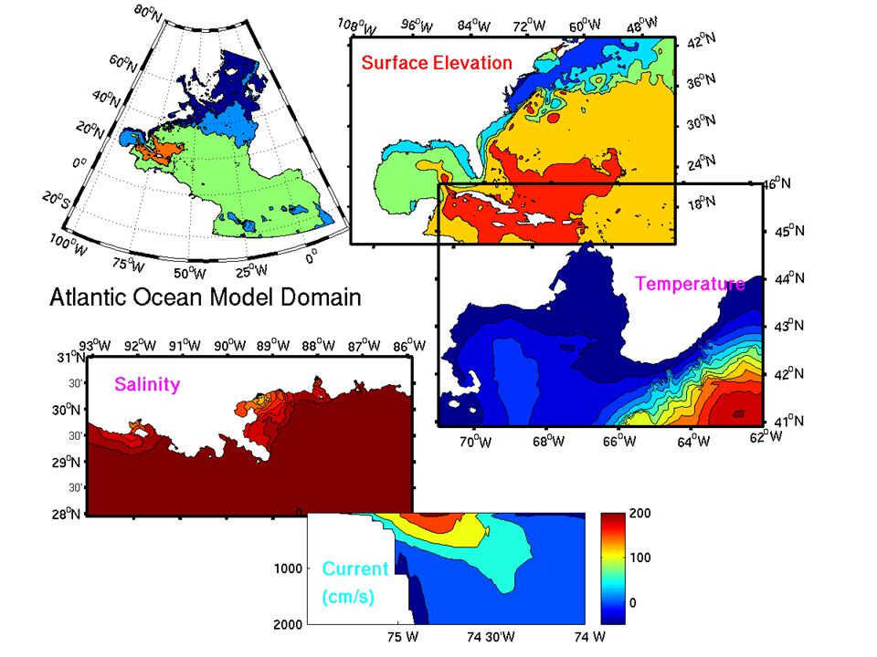
North Atlantic Ocean Domain Resolution: 4-5 km US coast, 7km Gulf Stream

28
4. Hurricane Impacts Modeling Coupled hurricane ocean model improves storm intensity when ocean interaction is strong Slow moving storms Motion over shallow mixed layers Motion across strong SST gradients Gulf Stream & Loop Current –GFDL coupled model operational in 2001 –Improved flexibility for system relocation Cover the full variety of hurricane genesis locations hurricane genesis locations Basin scale real-time ocean system described above –Partners include University of Rhode Island and GFDL –Future development includes Coupled wave forecast upgrade Coupled Hurricane Weather Research and Forecast (WRF) model
 model.")
30
Ongoing projects Atlantic Ocean Forecast System. Preparation for operations. Coupled ocean/storm-surge & inundation. Collaboration with NOS. Hurricane atmosphere-ocean coupled model. Collaboration with URI. Assimilation of Sea Surface Height. Skin sea surface temperature.

31
Schedule North Atlantic World Oceans North-East Pacific Hawaii 2006 2006-2007 2007- Initiate Global atmosphere-ocean Coupling and Hurricane- Ocean Coupling Initiate interactions with NOS on bay and estuary model boundary conditions; Initiate wave-current interactions.

32
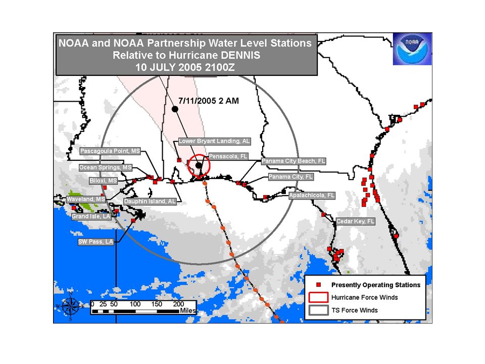
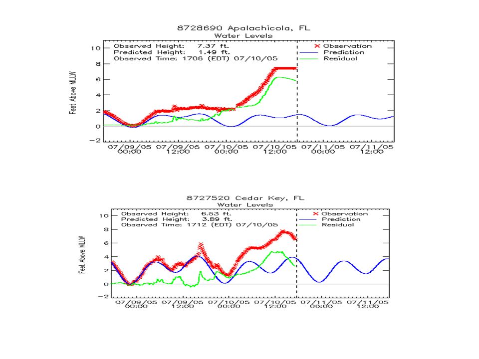
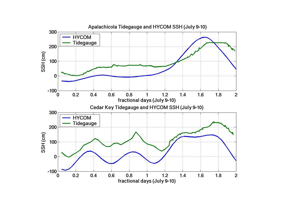
HYCOM SSH and Storm Surge in Hurricane Dennis July 9-10, 2005

Similar presentations


 Model description: – Third generation wave model developed at NOAA/NCEP. – Solves.>")


 June 11-12, 2007 3.3 Modeling and Analysis Subsystem {SWG3.3 Chair,>")


 Prediction System Next generation non-hydrostatic weather research and hurricane prediction system.>")


 Team: Avichal Mehra, Ilya Rivin, Bhavani Balasubramaniam, Todd Spindler, Zulema Garaffo, Hendrik.>")


 Patrick J. Hogan and Harley E. Hurlburt Naval Research Laboratory, Code 7323, Stennis Space Center,>")


 Ming Ji, Director “where NOAA’s ocean obs.,>")