Download presentation
Presentation is loading. Please wait.

1
Post Processing of Hurricane Model Forecasts T. N. Krishnamurti Florida State University Tallahassee, FL Collaborators: Anu Simon, Mrinal Biswas, Andrew Martin, Christopher Davis, Aarolyn Hayes, Naomi Surgi, TSV Vijaya Kumar

2
ARW Model Description The real-time ARW forecasts in 2005 used a two-way nested configuration (Michalakes et al. 2005), that featured a 12-km outer fixed domain with a movable nest of 4/1.33-km grid spacing.Michalakes et al. 2005 The nest was centered on the location of the minimum 500-hPa geopotential height within a prescribed search radius from the previous position of the vortex center (or within a radius of the first guess, when first starting). Nest repositioning was calculated every 15 simulation minutes and the width of the search radius was based on the maximum distance the vortex could move at 40 m s −1. On the 12-km domain, the Kain–Fritsch cumulus parameterization was used, but domains with finer resolution had no parameterization. All domains used the WRF single-moment 3-class (WSM3) microphysics scheme (Hong et al. 2004) that predicted only one cloud variable (water for T > 0°C and ice for T < 0°C) and one hydrometeor variable, either rainwater or snow (again thresholded on 0°C).Hong et al. 2004 Both domains also used the Yonsei University (YSU) scheme for the planetary boundary layer (Noh et al. 2003).Noh et al. 2003 This is a first-order closure scheme that is similar in concept to the scheme of Hong and Pan (1996), but appears less biased toward excessive vertical mixing as reported by Braun and Tao (2000).Hong and Pan (1996)Braun and Tao (2000) The drag formulation follows Charnock (1955) and is described more in section 5. The surface exchange coefficient for water vapor follows Carlson and Boland (1978), and the heat flux uses a similarity relationship (Skamarock et al. 2005).Charnock (1955)section 5Carlson and Boland (1978)Skamarock et al. 2005 The forecasts were integrated from 0000 UTC and occasionally 1200 UTC during the time when a hurricane threatened landfall within 72 h. Forecasts were initialized using the Geophysical Fluid Dynamics Laboratory (GFDL) model, with data on a ⅙ ° latitude–longitude grid. The Global Forecast Model (GFS) from the National Centers for Environmental Prediction (NCEP), obtained on a 1° grid, was used only when the GFDL was unavailable. Davis, C., W. Wang, S.S. Chen, Y. Chen, K. Corbosiero, M. DeMaria, J. Dudhia, G. Holland, J. Klemp, J. Michalakes, H. Reeves, R. Rotunno, C. Snyder, and Q. Xiao, 2008: Prediction of Landfalling Hurricanes with the Advanced Hurricane WRF Model. Mon. Wea. Rev., 136, 1990–2005.
, that featured a 12-km outer fixed domain with a movable nest of 4/1.33-km grid spacing.Michalakes et al The nest was centered on the location of the minimum 500-hPa geopotential height within a prescribed search radius from the previous position of the vortex center (or within a radius of the first guess, when first starting). Nest repositioning was calculated every 15 simulation minutes and the width of the search radius was based on the maximum distance the vortex could move at 40 m s −1. On the 12-km domain, the Kain–Fritsch cumulus parameterization was used, but domains with finer resolution had no parameterization. All domains used the WRF single-moment 3-class (WSM3) microphysics scheme (Hong et al. 2004) that predicted only one cloud variable (water for T > 0°C and ice for T < 0°C) and one hydrometeor variable, either rainwater or snow (again thresholded on 0°C).Hong et al Both domains also used the Yonsei University (YSU) scheme for the planetary boundary layer (Noh et al. 2003).Noh et al This is a first-order closure scheme that is similar in concept to the scheme of Hong and Pan (1996), but appears less biased toward excessive vertical mixing as reported by Braun and Tao (2000).Hong and Pan (1996)Braun and Tao (2000) The drag formulation follows Charnock (1955) and is described more in section 5. The surface exchange coefficient for water vapor follows Carlson and Boland (1978), and the heat flux uses a similarity relationship (Skamarock et al. 2005).Charnock (1955)section 5Carlson and Boland (1978)Skamarock et al The forecasts were integrated from 0000 UTC and occasionally 1200 UTC during the time when a hurricane threatened landfall within 72 h. Forecasts were initialized using the Geophysical Fluid Dynamics Laboratory (GFDL) model, with data on a ⅙ ° latitude–longitude grid. The Global Forecast Model (GFS) from the National Centers for Environmental Prediction (NCEP), obtained on a 1° grid, was used only when the GFDL was unavailable. Davis, C., W. Wang, S.S. Chen, Y. Chen, K. Corbosiero, M. DeMaria, J. Dudhia, G. Holland, J. Klemp, J. Michalakes, H. Reeves, R. Rotunno, C. Snyder, and Q. Xiao, 2008: Prediction of Landfalling Hurricanes with the Advanced Hurricane WRF Model. Mon. Wea. Rev., 136, 1990–")
3
Post processing diagnostics Here we shall be showing some post processing for WRF-ARW. This model is presently being added to our suite of mesoscale models.

4
Predicted storm center location at indicated valid times (below) is denoted by blue star in each figure. Wind fields from AHW forecasts have been shifted to observed locations to facilitate comparison. HWind valid times are (a) 1132 UTC 29 Aug 10-m wind from AHW real-time forecasts with contours of nearest HWind (black lines) analyses overlaid Katrina, valid time = 1200 UTC 29 Aug (60-h forecast)
 1132 UTC 29 Aug 10-m wind from AHW real-time forecasts with contours of nearest HWind (black lines) analyses overlaid Katrina, valid time = 1200 UTC 29 Aug (60-h forecast).")
5
(a) Maximum 10-m wind and (b) minimum sea level pressure for forecasts of Katrina beginning 0000 UTC 27 Aug. Legend labels 1.33, 4, and 12 km refer to grid spacing of WRF ARW, version 2.1.2, using the Charnock drag relation. The forecast on a 12-km grid used the Kain– Fritsch parameterization. The 4-km real time (gray dashed) refers to the forecast made in real time with an innermost nest of 4-km grid spacing. All retrospective forecasts were initialized with the GFDL initial condition. Predicted intensity and minimum sea level pressure at different forecast hours
 refers to the forecast made in real time with an innermost nest of 4-km grid spacing. All retrospective forecasts were initialized with the GFDL initial condition. Predicted intensity and minimum sea level pressure at different forecast hours.")
6
Shown here is 10-m wind speed (m s−1) from 36-h Katrina forecast valid 1200 UTC 28 Aug on (a) the 12-km grid, (b) the 4-km grid, (c) the 1.33- km grid, and (d) the NOAA HWind product valid 1200 UTC 28 Aug. White ellipses in (d) are an approximate trace of the radii of maximum wind at each azimuth around the vortices in (a), (b), and (c). Size of the storm as seen by the predicted wind field at different resolutions compared to HWIND.
 are an approximate trace of the radii of maximum wind at each azimuth around the vortices in (a), (b), and (c). Size of the storm as seen by the predicted wind field at different resolutions compared to HWIND..")
7
Model-derived reflectivity at 3-km MSL valid 2300 UTC 28 Aug from nest with (a) 1.33-km grid increment and (b) 4-km grid increment. (c) Observed radar reflectivity composite valid between 2000 and 2100 UTC 28 Aug based on tail Doppler radar data from both the NOAA P-3 (red track) and the Naval Research Laboratory P-3 (pink track) with the Electra Doppler radar (ELDORA). 1.33 km 4 km OBS composite radar
 Observed radar reflectivity composite valid between 2000 and 2100 UTC 28 Aug based on tail Doppler radar data from both the NOAA P-3 (red track) and the Naval Research Laboratory P-3 (pink track) with the Electra Doppler radar (ELDORA) km 4 km OBS composite radar.")
8
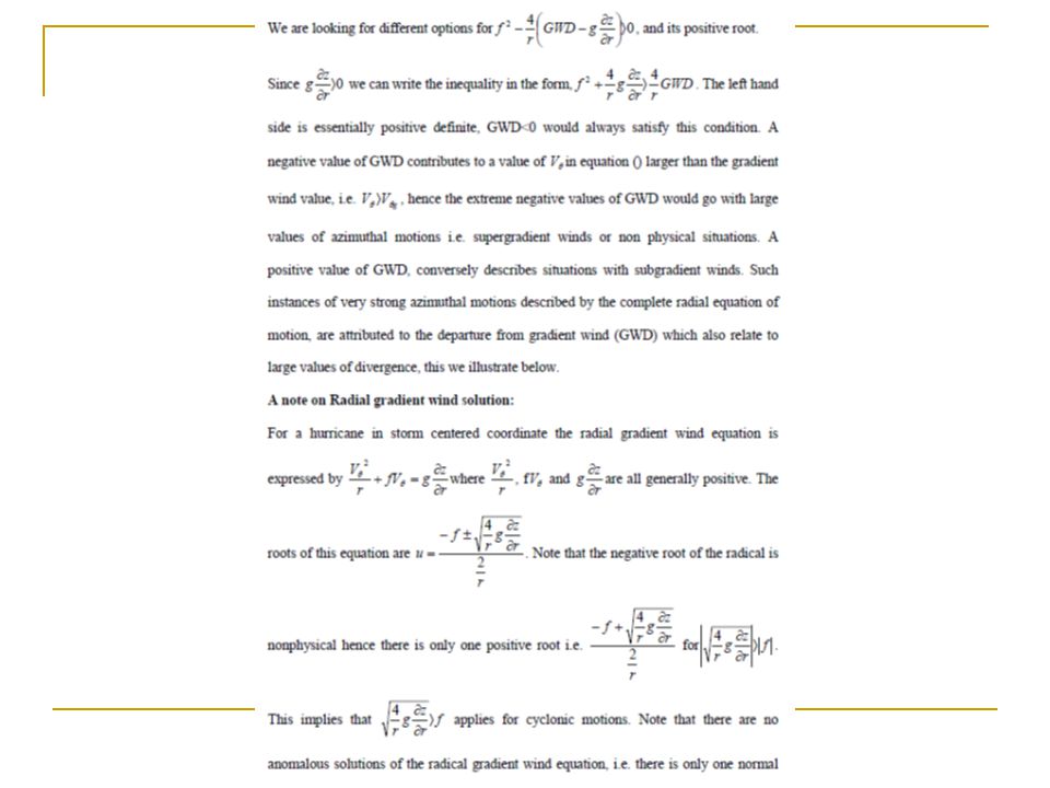
Departures from balance laws The full divergence equation can be written in the form (from Fankhauser 1974): Red lines represent the balance equation (Haltiner and Williams 1980). The blue underlined terms denote the non linear balance which is also expressed as.

13
1.Deep convection flares up near the eye wall, as seen from the local growth of rain water mixing ratio, liquid water mixing ratio or radar reflectivity as implied from model hydrometeors. 2.Divergence flares up 3.Departures from balance laws flare up 4. Solution of complete radial equation shows rapid growth of hurricane intensity. We have routinely mapped the field of GWD/ in the intensifying and decaying phases of hurricane intensity. We shall next illustrate several examples of the following scenario:

14
These panels correspond closely to the period of maximum intensity of Katrina

15
Initial time: 10z 28 August 2005 10 -5 Cloud Liquid Water Hourly plots

16
10 -5 Initial time: 09z 28 August 2005 Cloud Liquid Water Hourly plots

17
Initial time: 09z 28 August 2005 10 -5 Cloud Liquid Water Hourly plots

18
Initial time: 09z 28 August 2005 10 -5 Cloud Liquid Water Hourly plots

19
DIVERGENCE

20
CLOUD LIQUID WATER

23
Life cycle of a cloud

25
Observations Required Radar Reflectivity 3-Dimensional Winds Pressure Altitude

26
Vertical differential of heating in the complete potential vorticity equation, a diagnostic tool

27
(x 10 4 ) K/s PV (x 10 -7 ) m 2 s -1 kg -1 K Hurricane IVAN, 11 September 2004, 12z.10 -7 ) m 2 s -1 kg -1 K m 2 kg -1 K
 K/s PV (x ) m 2 s -1 kg -1 K Hurricane IVAN, 11 September 2004, 12z ) m 2 s -1 kg -1 K m 2 kg -1 K")
28
Contour plots of horizontal advection (x 10 -10 Kg -1 m 2 s -2 K) for hurricane IVAN 7 September through 12 September 2005 at 00z.
 for hurricane IVAN 7 September through 12 September 2005 at 00z.")
29
Contour plots of vertical advection of PV(x 10 -10 Kg -1 m 2 s- 2 K) for hurricane IVAN, 7 September through 12 September 2005 at 00z.
 for hurricane IVAN, 7 September through 12 September 2005 at 00z.")
30
Contour plots of vertical differential of heating (x 10 -10 Kg -1 m 2 s -2 K) for hurricane IVAN, 7 September through 12 September 2005 at 00z.
 for hurricane IVAN, 7 September through 12 September 2005 at 00z.")
31
Vertical distribution of the Horizontal Advection (green), Vertical Advection (purple), Vertical Differential of heating (Blue), Horizontal Differential of heating (orange) for the Potential Vorticity during the intensifying stage of Hurricane IVAN, through 7 to 12, 2005 at 00z. The total diabatic heating is shown in black. Units are x 10 -10 Kg -1 m 2 s -2 K

32
The time rate of change of vertical differential of heating (black solid line) and that for intensity (black dashed line) for the individual hurricanes for the years 2004-2006. The abscissa is a relative time scale and ordinate denotes a scale for the time rate of change. Least square fit of the above two curves.

33
We shall next show how the rapid increase of divergent kinetic energy gets transformed into rotational kinetic energy leading to a stronger storm Hurricane Katrina 8/28/05 12Z – 8/29/05 15Z Every 3 hours And several other hurricanes during 2004 - 2006

34
Equations for Psi-Chi Interactions Term 4The important terms are Term 1 and Term 2 Term 1Term 2Term 3 large 0 0

35
Term 1Term 2Term 3 There are four terms in the psi-chi interactions, these measure the rate of transfer of divergent kinetic energy into rotational kinetic energy. As deep convection flares up divergent motions amplify and a strong conversion of divergent to rotational motion follows, continually imbalanced flows grow and a rapid intensification of hurricane winds follow. Term 4

36
(m 2 s -3 )
")
38
Red line is intensity; Blue line is the sum of the first two terms These results are averages over 100 km radius at 850 hPa

39
Red line is intensity; Blue line is the sum of the first two terms

40
Storm-Relative Eulerian Absolute Angular Momentum Tendencies in Atlantic Tropical Cyclones

41
Cross-section Composites of Horizontal Advection in Storms Category 2 and Higher Strengthening Storms Weakening StormsStrengthening StormsWeakening Storms T-test CI Km from center Pressure (hPa) -150 -100 -50 0 100 150 50 0.55 Pressure (hPa) 0.55 0.65 0.75 0.85 0.95 -150 -100 -50 0 100 150 50 -100 -60 -20 20 100 60 -100 -60 -20 20 60 100 -120 -80 -40 0 80 120 40 -36 -24 -12 12 24 36 Pressure (hPa) 0.85 0.95 0.75 0.65 Strengthening - Weakening Km from center 0
 Pressure (hPa) Pressure (hPa) Strengthening - Weakening Km from center 0")
42
Conclusions and future work contd.. Future work on mesoscale modeling during the hurricane season of 2009 will include the following models: HWRF(EMC), HWRF-X(HRD), WRF/ARW (NCAR), COAMPS (NRL),GFDL(NOAA), MM5 (FSU), WRF(FSU). Rapid intensity changes over regions of cloud burst seem to go with growth of lower tropospheric convergence, growth of departure from balance laws and supergradient winds. This scenario appears to carry a lead time of only an hour (roughly) between the time of the cloud burst and the generation of supergradient winds. Local wind maxima thus generated are seen to sweep azimuthal distances of the order of 50 km in a matter of an hour. There are a host of dynamical parameters that deserve to be examined over the inner core of hurricanes for the post processing of model output. We have noted the following to be important, in relating to hurricane intensity changes: vertical differential of heating of the complete pv equation; energy transfer from the divergent to the rotational kinetic energy; advection of earths and relative angular momentum in storm relative coordinates; contributions of the kinematic transfer of shear vorticity to the curvature vorticity.
, HWRF-X(HRD), WRF/ARW (NCAR), COAMPS (NRL),GFDL(NOAA), MM5 (FSU), WRF(FSU). Rapid intensity changes over regions of cloud burst seem to go with growth of lower tropospheric convergence, growth of departure from balance laws and supergradient winds. This scenario appears to carry a lead time of only an hour (roughly) between the time of the cloud burst and the generation of supergradient winds. Local wind maxima thus generated are seen to sweep azimuthal distances of the order of 50 km in a matter of an hour. There are a host of dynamical parameters that deserve to be examined over the inner core of hurricanes for the post processing of model output. We have noted the following to be important, in relating to hurricane intensity changes: vertical differential of heating of the complete pv equation; energy transfer from the divergent to the rotational kinetic energy; advection of earths and relative angular momentum in storm relative coordinates; contributions of the kinematic transfer of shear vorticity to the curvature vorticity..")
43
Future work In order to further exploit these findings, we have designed a unified index that is derived from multiple regression for the intensity change using a least square minimization principle that includes all of the above parameters. Such an index would be most useful for real time operations. It should be stated that the parameters we have selected are not all-inclusive; such a list must be expanded and tested as newer ideas develop. The post spin-up data sets are ideally suited for developing single or combined indices for studying the rapid intensification or weakening. A combined index is described by the following multiple regression equation. Intensity Change = i PR i (1) where i are weights determined by a least square minimization principle and PR i are the different candidate parameters. Time rate of change
 where i are weights determined by a least square minimization principle and PR i are the different candidate parameters. Time rate of change.")
44
THANKS

Similar presentations


 to the choice of the cloud and precipitation scheme Yuqing Wang and Qingqing Li International.>")

 Hua Chen Committee members: Dr. Da-Lin Zhang (Advisor) Dr. James Carton Dr. Chuan Liu (Dean’s Representative)>")
 Kristen L. Corbosiero, Wei Wang, Yongsheng Chen, Jimy Dudhia.>")


 Stefan Cecelski 1 and Dr. Da-Lin Zhang Department of Atmospheric and Oceanic Science.>")
 to Planetary Boundary Layer Parameterizations SCOTT A. BRAUN AND WEI-KUO TAO PRESENTATION.>")

 Associated With the ITCZ Breakdowns The UMD/NASA-GSFC Users' and Developers' Workshop,>")


 Zhan Li and Zhaoxia Pu.>")
 JungHoon Shin and Da-Lin Zhang Department of Atmospheric & Oceanic.>")
 Prediction System Next generation non-hydrostatic weather research and hurricane prediction system.>")
 Falko Judt and Shuyi S. Chen Rosenstiel School of Marine and Atmospheric Science, University.>")

