Download presentation
Presentation is loading. Please wait.

1
On the Rapid Intensification of Hurricane Wilma (2005) Hua Chen Committee members: Dr. Da-Lin Zhang (Advisor) Dr. James Carton Dr. Chuan Liu (Dean’s Representative) Dr. Xin-Zhong Liang Dr. Kayo Ide Dr. Takemasa Miyoshi
 Dr. James Carton Dr. Chuan Liu (Dean’s Representative) Dr. Xin-Zhong Liang Dr. Kayo Ide Dr. Takemasa Miyoshi.")
3
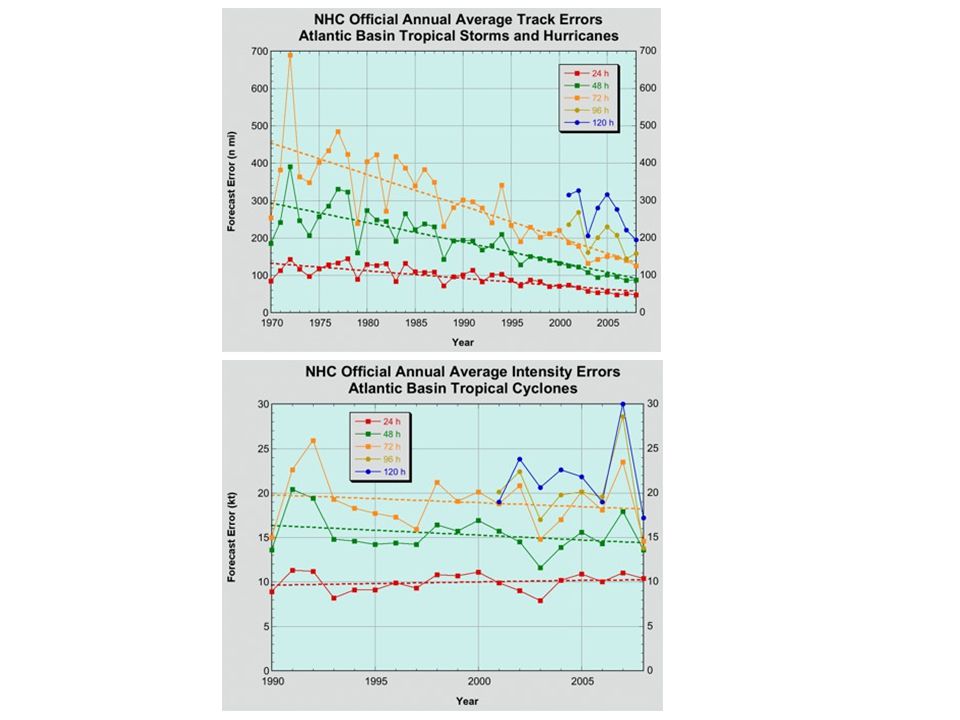
Overview of Hurricane Wilma (2005) Record intensity in the Atlantic basin – 882 hPa Record intensification rate: 54 hPa/6 h, 83 hPa/12h, and 97 hPa/24 h ( RI Def: > 1.5 hPa/hr) Record small eye size: 5 kilometer in diameter Huge storm surge: 12 - 14 feet surge Torrential rainfall: 1600 mm rainfall/24h at Yucatan peninsula Above the mean fcst errors: track - 160 km/48 h, 250 km/72 h, and large intensity underforecast (GFDL: 924 hPa and 50 m s -1 ).
 Record intensity in the Atlantic basin – 882 hPa Record intensification rate: 54 hPa/6 h, 83 hPa/12h, and 97 hPa/24 h ( RI Def: > 1.5 hPa/hr) Record small eye size: 5 kilometer in diameter Huge storm surge: feet surge Torrential rainfall: 1600 mm rainfall/24h at Yucatan peninsula Above the mean fcst errors: track km/48 h, 250 km/72 h, and large intensity underforecast (GFDL: 924 hPa and 50 m s -1 ).")
4
Outline Numerical prediciton Model description Model Verification Diagnostic analysis The upper level warm core Small symmetric eyewall

5
Model Description (WRF-ARW) Two-way, movable, quadruply nested (27/9/3/1 km), 55 levels in the vertical; Thompson et al. (2004) 3-ice cloud microphysics scheme; The Betts-Miller-Janjic cumulus scheme for 27 and 9 km; The YSU PBL scheme; NOAH surface-layer physics; Cloud-radiation interaction scheme; Initial and boundary conditions: The GFDL’s then operational data, except for the specified daily SST; Integration period: 0000 UTC 18 ~ 0000 UTC 21 October 2005 (72 h) for all the four meshes.
 3-ice cloud microphysics scheme; The Betts-Miller-Janjic cumulus scheme for 27 and 9 km; The YSU PBL scheme; NOAH surface-layer physics; Cloud-radiation interaction scheme; Initial and boundary conditions: The GFDL’s then operational data, except for the specified daily SST; Integration period: 0000 UTC 18 ~ 0000 UTC 21 October 2005 (72 h) for all the four meshes..")
7
NASA/GSFC, 26 March 2012 The best track (dashed) vs the 72-h predicted track (solid), SST (shaded), SST (00 Z 19 – 00 Z 18; contoured) Observed Predicted
 vs the 72-h predicted track (solid), SST (shaded), SST (00 Z 19 – 00 Z 18; contoured) Observed Predicted")
9
A B C D Visible Satellite picture Predicted reflectivity at 1-km altitude 1900 UTC 18 OCT 1800 UTC 18 OCT

11
Verification against the flight-level observations RMW = 7 km RMW = 15 km ObservedPredicted

12
Hypothesis – upper level warm core An upper level warm core is important for RI; The upper level warm core results from the descending air in the lower stratosphere due to convective bursts This upper level warm core is protected by the symmetric divergent outflow at upper level from ventilation; Convective bursts, driven by high SSTs, play an important role in generating the upper-level warm core.

13
Hypothesis – upper level warm core An upper level warm core is important for RI; The upper level warm core results from the descending air in the lower stratosphere due to convective bursts This upper level warm core is protected by the symmetric divergent outflow at upper level from ventilation; Convective bursts, driven by high SSTs, play an important role in generating the upper-level warm core.

14
Shadings: Temperature perturbation with respect to t = 0; Contours: Potential temperature Wind barbs all taken at the eye center. Total warming Warming above 380 K Warming below 380 K a) b)
 b).")
15
380 K t = 36 h 340 K

16
Efficiency of upper level warming T1+∆T T2 T1 T2+∆T PaPa PbPb PtPt

17
Hypothesis – upper level warm core An upper level warm core is important for RI; The upper level warm core results from the descending air in the lower stratosphere due to convective bursts This upper level warm core is protected by the symmetric divergent outflow at upper level from ventilation; Convective bursts, driven by high SSTs, play an important role in generating the upper-level warm core.

18
Pre-RI RI Post-RI

19
The cloud field at z = 17.5 km and CBs. The red circle is the RMW at z = 1 km t = 30 h, t = 30.08h

20
Vertical cross section of cloud hydrometeors (shaded, g kg -1 ), storm-relative flow vectors, and vertical motion (downward/dashed every 1 m s -1 and upward/solid every 3 m s -1 ). NASA/GSFC, 26 March 2012

21
Hypothesis – upper level warm core An upper level warm core is important for RI; The upper level warm core results from the descending air in the lower stratosphere due to convective bursts This upper level warm core is protected by the symmetric divergent outflow at upper level from being ventilated; Convective bursts, driven by high SSTs, play an important role in generating the upper-level warm core.

22
Higher altitude of warm core at t =30 h; Higher outflow layer at t=30 h; Higher inflow layer at t=30 h; a b t = 30 h t = 54 h Warm core is located at the same altitude as the outflow layer Differences: Common feature:

23
RI onset Shading: θ Red contour: Upward motion Blue contour: Downward motion Black circle: RMW at Z = 1 km “W”: warm anomaly Z = 14 km

24
Pre-RI Shading: θ Red contour: Upward motion Blue contour: Downward motion Black circle: RMW at Z = 1 km “W”: warm anomaly Z = 14 km

25
Internal gravity wave movie

26
Hypothesis – upper level warm core An upper level warm core is important for RI; The upper level warm core results from the descending air in the lower stratosphere due to convective bursts This upper level warm core is protected by the symmetric divergent outflow at upper level from ventilation; Convective bursts, driven by high SSTs, play an important role in generating the upper-level warm core.

27
NASA/GSFC, 26 March 2012 The 18/6/2 km control simulation The SST-1 sensitivity simulation CTL: 3.5 hPh/hr SST-1: 1.9 hPa/hr

28
2-km control 2-km SST-1 Time Series of the number of Intense updrafts

29
Hypothesis – small symmetric eyewall The small eye is important; The symmetric patter is important

30
Hypothesis – small symmetric eyewall The small eye is important; The symmetric patter is important

31
Adapted from Schubert and Hack (1982) Onset of RI
 Onset of RI")
32
AAM conservation Gradient wind balance solid body rotation

33
Hypothesis – small symmetric eyewall The small eye is important; The symmetric patter is important

34
Why does the eyewall becomes from asymmetric to symmetric?

35
Why symmetric pattern is important for RI?

36
How does the eye size contract fast in pre-RI stage? Shading: radar reflectivity contour: Vorticity “A”, “B” denote the rainbands.

37
Small symmetric eyewall forms!

38
Conclusion WRF model reproduces reasonable well the track, intensity and storm structure given the reasonable configuration; An upper level warm core is important for the storm to undergo RI because of its efficiency; The upper level warm core results from the descending air in the lower stratosphere due to convective bursts This upper level warm core is protected by the symmetric divergent outflow at upper level from ventilation; Convective bursts, driven by high SSTs, play an important role in generating the upper-level warm core.

39
Conclusion -continued The small eye size is important in determining RI; The asymmetric pattern is hostile to RI because it induces tilting and the asymmetric divergent outflow advects warming away from the center; The change of vertical wind shear with time is a key factor for the trigger of RI since it prevents the formation of a large symmetric eyewall at early stage.

40
Future work Perform more clear SST sensitivity tests to identify its impact on convective bursts and associated warm core; Microphysics sensitivity test.

41
Any questions?

Similar presentations


 to the choice of the cloud and precipitation scheme Yuqing Wang and Qingqing Li International.>")
>")

 Kristen L. Corbosiero, Wei Wang, Yongsheng Chen, Jimy Dudhia.>")
 from an African Easterly Wave Stefan Cecelski 1 and Dr. Da-Lin Zhang Department of Atmospheric and Oceanic Science, University.>")

 Stefan Cecelski 1 and Dr. Da-Lin Zhang Department of Atmospheric and Oceanic Science.>")
 Associated With the ITCZ Breakdowns The UMD/NASA-GSFC Users' and Developers' Workshop,>")
, wind speed (shaded, m s −1 ), 300 hPa divergence (negative values dashed, 10 −6 s −1 ) 60 50 40 30 n = 22 MSLP (solid, hPa),>")


 Zhan Li and Zhaoxia Pu.>")
 JungHoon Shin and Da-Lin Zhang Department of Atmospheric & Oceanic.>")

 and Danny (1997) Matthew S. Potter, Lance F. Bosart, and Daniel Keyser.>")
 Falko Judt and Shuyi S. Chen Rosenstiel School of Marine and Atmospheric Science, University.>")

: Insights from New Remote Sensing Measurements Collaborators: Anthony Didlake (NPP/GSFC),Gerry Heymsfield.>")