Download presentation
Presentation is loading. Please wait.

1
Introduction Introduction

2
Summary of Topics - GPS - WAAS - Coordinate Systems - Datums

3
1973 – U.S. Air Force tasked with initial development1973 – U.S. Air Force tasked with initial development 1980’s – First civilian use1980’s – First civilian use 1995 – GPS declared “Fully Operational”1995 – GPS declared “Fully Operational” 2000 – “Selective Availability” suspended2000 – “Selective Availability” suspended Today – Wide variety of products and services utilize GPS technology, and the European Union builds its own GPSToday – Wide variety of products and services utilize GPS technology, and the European Union builds its own GPS A Brief History Of GPS

4
Apply GPS To Fire Situations Report a fire’s locationReport a fire’s location Navigate to a fire’s reported locationNavigate to a fire’s reported location Map a fire’s point of origin, or its perimeterMap a fire’s point of origin, or its perimeter Locate a safety zone, helispot, pump, water source, or other point of interestLocate a safety zone, helispot, pump, water source, or other point of interest Map roads or trails to be used for accessMap roads or trails to be used for access Map resources or improvements to be protectedMap resources or improvements to be protected Map dozer line to be rehabilitatedMap dozer line to be rehabilitated Document search, rescue, or recovery effortsDocument search, rescue, or recovery efforts

5
How does GPS work?

6
The Global Positioning System Control Segment Space Segment User Segment

7
Kwajalein Atoll US Space Command Control Segment Hawaii Ascension Is. Diego Garcia Cape Canaveral Ground Antenna Master Control Station Monitor Station

8
The Space Segment 24 or more satellites in Earth orbit that transmit: PRN codePRN code Ephemeris dataEphemeris data Atmospheric dataAtmospheric data Clock informationClock information An almanacAn almanac

9
JTrackJTrack http://liftoff.msfc.nasa.gov/RealTime/JTrack/3D/JTrack3D.html Altitude 20,200 km 10,900 nm

10
Earth in a Cage of Satellites Current:Satellites 1 - 32 Max:32 Satellites

11
Military Search and rescue Disaster relief Surveying Marine, aeronautical and terrestrial navigation Remote controlled vehicle and robot guidance Satellite positioning and tracking Shipping Geographic Information Systems (GIS) Recreation User Segment
 Recreation User Segment")
12
How to Calculate a Position Measure the Distance to the Satellites

13
How to Calculate Distance Speed of Light x Travel Time Distance Time signal left satellite Time current

14
Minimum # of Satellites Required -Algebra Problem Unknown time latitude longitude elevation 4 4 Unknowns We Need 4 Satellites Equation satellite location

15
Minimum # of Satellites Required -Trilateration 1 satellite – somewhere on a sphere

16
Minimum # of Satellites Required -Trilateration 2 satellites – somewhere on a circle

17
Minimum # of Satellites Required -Trilateration 3 satellites – one of two points

18
Minimum # of Satellites Required -Trilateration Note: with 3 satellites, one point is on the earth’s surface and one is nowhere near. However, we still need the 4 th satellite because receiver clocks are inaccurate. 4 satellites – one point 3D GPS Location

19
When There are Only 3 Satellites 2D GPS Location Elevation - last known 2-5 X Error Rule

20
-Want tetrahedron as large as possible -Want index as low as possible Garmin Estimated Accuracy Relies on Dilution of Precision DOPs TDOP VDOP HDOP PDOP GDOP DOPs TDOP VDOP HDOP PDOP GDOP

21
Ideal Satellite Geometry N S W E

22
Good Satellite Geometry

23
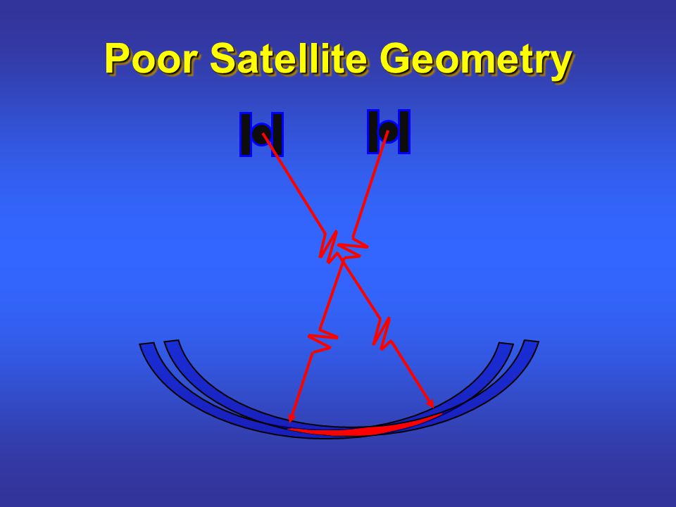
Poor Satellite Geometry N S W E

25
Positions Recorded by Stationary GPS Receiver Garmin GPSmap76S 1 position/second 10 minutes WAAS Disabled 3.6 meters 3.1 meters

26
Errors (tens of meters) Ionosphere Troposphere Satellite Clock Errors Satellite Ephemeris Errors Multipath Receiver Noise
 Ionosphere Troposphere Satellite Clock Errors Satellite Ephemeris Errors Multipath Receiver Noise")
27
DGPS Site x+30, y+60 x+5, y-3 True coordinates = x+0, y+0 Correction = x-5, y+3 DGPS correction = x+(30-5) and y+(60+3) True coordinates = x+25, y+63 x-5, y+3 Real Time Differential GPS DGPS Receiver Receiver
 and y+(60+3) True coordinates = x+25, y+63 x-5, y+3 Real Time Differential GPS DGPS Receiver Receiver")
28
WAAS satellites GPS Constellation WAAS Control Station (Position known) GPS receiver (Position with errors) Wide Area Augmentation System 25 Reference Stations (Position known)
 GPS receiver (Position with errors) Wide Area Augmentation System 25 Reference Stations (Position known)")
29
WAAS Wide Area Augmentation System WAAS Satellite

30
Errors Reduced by WAAS Correction (multi-meter) Errors Reduced by WAAS Correction (multi-meter) Ionosphere Troposphere Satellite Clock Errors Satellite Ephemeris Errors Multipath Receiver Noise
 Errors Reduced by WAAS Correction (multi-meter) Ionosphere Troposphere Satellite Clock Errors Satellite Ephemeris Errors Multipath Receiver Noise")
31
Receiving WAAS Correction If WAAS signal intermittent- WAAS correction for SV 19 No WAAS correction for SV 11 WAAS correction for SV 19 No WAAS correction for SV 11

32
Caution! If WAAS Enabled – - 2D WAAS chosen over 3D uncorrected - WAAS chosen over DOP Recommendation If WAAS signal intermittent (example: under canopy) - disable WAAS
 - disable WAAS.")
33
Signal Disruption Ionosphere Solid Structures Metal Electro-magnetic Fields

34
Good Data Collection Techniques External Antenna Map76S more accurate under canopy Sleeve Mounts Vehicle Brackets

35
Map Projections & Coordinate Systems

36
Projecting a Sphere Onto a Plane Three-dimensional sphere to two-dimensional flat map.

37
Examples of Several Projections Depending on the projection, a certain amount of distortion occurs when portraying the earth on paper.

38
Coordinate Systems (Projections) We Use – 2 Coordinate Systems Latitude / Longitude Universal Transverse Mercator (UTM) Garmin - 29 Location Formats
 We Use – 2 Coordinate Systems Latitude / Longitude Universal Transverse Mercator (UTM) Garmin - 29 Location Formats")
39
0º 0º Point of Origin Prime Meridian Equator (Longitude) (Latitude) 10º N 30º N 10º S Latitude & Longitude
 (Latitude) 10º N 30º N 10º S Latitude & Longitude")
40
Parallels of Latitude 10º 10º 10º 690 miles 10º S 0º N 10º N 20º N

41
Meridians of Longitude 10º 10º 110º W 120º W 690 miles 460 miles 240 mi 10º Equator To North Pole To South Pole

42
Three Ways To Express Latitude / Longitude on a Garmin

43
Three Ways To Express Latitude / Longitude (for the Same Location) hddd° mm’ ss.s” Degrees-Minutes-Seconds (Decimal Seconds) N 43° 40’ 55.8”, W 116° 17’ 14.1” hddd° mm.mmm’ Degrees-Minutes (Decimal Minutes) N 43° 40.930’, W 116° 17.235’ hddd.ddddd° Degrees (Decimal Degrees) N 43.68216°, W 116.28725°
 hddd° mm’ ss.s Degrees-Minutes-Seconds (Decimal Seconds) N 43° 40’ 55.8 , W 116° 17’ 14.1 hddd° mm.mmm’ Degrees-Minutes (Decimal Minutes) N 43° ’, W 116° ’ hddd.ddddd° Degrees (Decimal Degrees) N °, W °")
44
Coordinate Systems hddd 0 mm’ ss.s”: N 43 0 40’ 55.8” X W 116 0 17’ 14.1” (55.8” / 60 =.93’) Different coordinates representing the same location: hddd 0 mm.mmm’: N 43 0 40.93’ X W 116 0 17.235’ (40.93’ / 60 =.68216 0 ) hddd.ddddd 0 : N 43.68216 0 X W 116.28725 0 UTM/UPS:11T 0557442m E 4836621m N
 Different coordinates representing the same location: hddd 0 mm.mmm’: N ’ X W ’ (40.93’ / 60 = ) hddd.ddddd 0 : N X W UTM/UPS:11T m E m N")
45
Example: Error in Latitude 35° 24´ 45˝ N 35° 24.450’ N 1/3 of a mile

46
Lat / Long Shortcomings 1 minute ? ? 1 degree 1 1 degree + + + ?

47
Universal Transverse Mercator measured in meters located in zones (1 - 60) include northing and easting are positive Coordinates Zone Easting Northing Latitude Band
 include northing and easting are positive Coordinates Zone Easting Northing Latitude Band")
48
UTM Zones in the Lower 48 10 11 12 13 14 15 16 17 18 19 UTM Zones

49
160 UTM Grid Overlay 60 Zones, and 20 Latitude Bands 21 G M W X 80º S 84º N D C E F H J K L N P Q R S T U V Latitude Bands 21 T T Zones Equator

50
Garmin Uses – UTM bands Bands C - M, southern hemisphere Bands N - X, northern hemisphere UTM Latitude Band Latitude Band We Use – 2 GIS choices UTM Zone _ North UTM Zone _ South no “I” no “O” no “I” no “O”

51
If You Don’t Know Zone, Latitude Band… Entering Waypoints Zone – look up Band – enter any letter C – M for northern hemisphere, receiver will display correct one Collecting Waypoints Receiver figures it out!

52
UTM Location Format on a Garmin

53
What is a datum?

54
Datums WGS 84 NAD 83 NAD 27 Garmin - >100 Map Datums We Use – 3 Datums 1 meter 10 - 120 meters

55
Example: Datum Shift in Arizona NAD83 N34.555 o, W111.195 o NAD27 210 meters

56
With a Garmin GPS Receiver you always collect in the right coordinate system and datum! Lat, Long WGS-84 UTC Lat, Long WGS-84 UTC Lat, Long NAD27 -8 GMT Lat, Long NAD27 -8 GMT UTM NAD83 UTC UTM NAD83 UTC Lat, Long WGS84 -9 GMT Lat, Long WGS84 -9 GMT Lat, Long NAD27 -8 GMT Lat, Long NAD27 -8 GMT UTM NAD83 GMT UTM NAD83 GMT Lat, Long WGS84 UTC Lat, Long WGS84 UTC Display doesn’t matter

57
Coordinate System? Datum? Coordinate System? Datum?

58
Review of Topics - GPS - WAAS - Coordinate Systems - Datums

Similar presentations


 Precise positioning service.>")


 for Precision Farming>")


