Download presentation
Presentation is loading. Please wait.

1
Texas and Oklahoma Panhandles Particularly Dangerous Winter Storm Expected Tonight Through Saturday Morning JJ Brost NWS Amarillo

2
L This Evening L Friday Morning L Friday Night Cold Air/Front Moving In From North This Evening

3
L Mostly Light Snow Beginning This Evening Across The Northwest Panhandles And Progressing Southeast

4
L Snow Intensity Increases And Expands Friday Morning Across Most Of Panhandles Heaviest Snow North West Texas And West Oklahoma Panhandles Strong North Winds Begin – Wind Speeds 30 to 40 MPH With Higher Gusts North Winds Speeds 20 to 30 MPH With Higher Gusts in the East

5
L Heavy Snow Continues Across The Entire Panhandles Heaviest Snow Oklahoma And North Texas Panhandles Strong North Winds Still An Issue – But, Should See Winds Decrease In Speeds During The Afternoon

6
L Strong North Winds Still An Issue In East Heaviest Snow East Oklahoma And Texas Panhandles

7
Snow Accumulations From 7:00 PM Thursday Through 8:00 AM Friday 6+ Inches 2+ Inches 4+ Inches Less Than 2 Inches

8
NEW Snow Accumulations From Friday 8:00 AM Through 8:00 PM Friday 8+ Inches 6+ Inches 4+ Inches 2+ Inches 10+ Inches

9
NEW Snow Accumulations From Friday 8:00 PM Through Saturday 8:00 AM 2+ Inches Generally Less Than 1 Inch

10
Total Snow Accumulations 12+ Inches 10+ Inches 6+ Inches 4+ Inches 14+ Inches

11
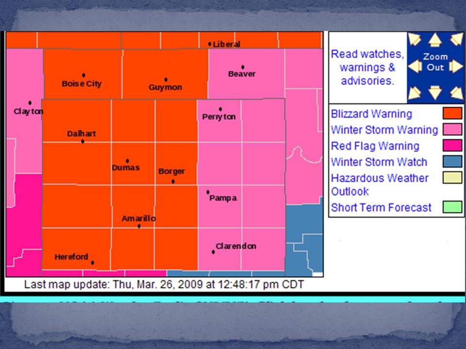
Blizzard/Winter Storm Warning - Begins Thursday Evening through Saturday Morning for the Panhandles: Particularly Dangerous Winter Storm Blizzard/Winter Storm Warning - Begins Thursday Evening through Saturday Morning for the Panhandles: Particularly Dangerous Winter Storm Weather Impacts: Weather Impacts: Heavy snow Heavy snow Most in Oklahoma and North Texas Panhandles Most in Oklahoma and North Texas Panhandles 14+ inches possible – Wide Spread 8+ inches 14+ inches possible – Wide Spread 8+ inches Snow Drifts – 10 to 20 FEET Snow Drifts – 10 to 20 FEET Blizzard Conditions Blizzard Conditions Wind speeds 30 to 40 MPH with higher gusts (55+ MPH) Wind speeds 30 to 40 MPH with higher gusts (55+ MPH) White Out Conditions due to Blowing and Drifting Snow White Out Conditions due to Blowing and Drifting Snow
 Wind speeds 30 to 40 MPH with higher gusts (55+ MPH) White Out Conditions due to Blowing and Drifting Snow White Out Conditions due to Blowing and Drifting Snow")
14
www.srh.noaa.gov/ama/march2009_blizzard/ Will be linked from our home page: www.srh.noaa.gov/ama

15
Power Outages Power Outages Road Closures Road Closures Snow Drifts – 10 to 20 FEET possible Snow Drifts – 10 to 20 FEET possible Elderly – Extra Attention Elderly – Extra Attention Medication, Shelter, Food Medication, Shelter, Food Conditions may last through weekend Conditions may last through weekend Have plenty of food and water Have plenty of food and water Fuel for generators Fuel for generators Wood for fires Wood for fires Batteries Batteries

16
Texas Panhandles: 806-468-1488 Texas Panhandles: 806-468-1488 State of Texas: 1-800-452-9292 State of Texas: 1-800-452-9292 Oklahoma: 1-405-425-2385 Oklahoma: 1-405-425-2385 New Mexico: 1-800-432-4269 New Mexico: 1-800-432-4269 Southeast Colorado: 1-303-639-1234 Southeast Colorado: 1-303-639-1234 Colorado: 1-303-639-1111 Colorado: 1-303-639-1111 Kansas: 1-800-585-7623 Kansas: 1-800-585-7623

Similar presentations


 Dan Miller Science and Operations Officer NWS/WFO Duluth, Minnesota.>")
 Prepared by: National Weather Service State College, PA>")


 Small storm passes to the SE, cold front to the NW +>")
