Download presentation
Presentation is loading. Please wait.

1
Understanding Weather and Climate 3rd Edition Edward Aguado and James E. Burt Anthony J. Vega

2
Part 4. Disturbances Chapter 11 Lightning, Thunder, and Tornadoes

3
Introduction Thunderstorms occur about 40,000 times per day over the globe Each of these produces a considerable amount of lightning and a few produce tornadoes Processes of Lightning Formation Cloud-to-cloud lightning, the most frequent type, occurs when discharges of electricity occur within a particular cloud or between clouds This is also called sheet lightning as the sky is typically uniformly lit while the stroke is buried within the cloud Cloud-to-ground lightning begins when negative charges build in a cloud base These charges eventually discharge onto the positively charged ground The ground is typically negatively charged but the cloud charge offsets this by repelling electrons below

4
Charge Separation Electrical charges must separate within portions of a cloud for lightning to initiate Positive charges typically accumulate in the upper areas of the cloud while negatively charged particles aggregate in lower portions Charge separation occurs in relation to ice crystals, the lighter positively charged crystals inhabit the upper reaches of the cloud while heavier crystals migrate to lower portions This thermoelectric effect is still being researched Another process, induction, may contribute to charge separation Induction is based on the fact that opposite charges attract such that the top of falling ice pellets will be negatively charged due to the positive charge of the upper atmosphere Finer ice crystals or small drops acquiring a positive charge, move to the upper cloud area while the heavier pellets stabilize in the lower areas of the cloud

5
Charge separation in a cloud leading to lightning

6
A strong electrical field occurs prior to lightning

7
Leaders, Strokes, and Flashes For cloud-to-ground lightning to occur, a stepped-leader must emanate from the cloud base The leader is essentially an ionized particle chamber about 10 cm (4 in) in diameter which forks repeatedly from a main channel Each section travels about 50 m in a microsecond The sections continue until contact is made with an unlike charged area (the ground) Upon connection, electrons flow resulting in an illuminated return stroke Although the electrical current is from the cloud to the ground, the return stroke is in the opposite direction Air in the conducting channel heats to about 30,000K (54,000 o F) Usually more than one stroke is needed to neutralize all negative ions Another leader, or dart leader, is initiated and a return stroke follows The process is repeated about 4-5 times on average Individual strokes are almost impossible to detect but the entire lightning flash, a combination of all strokes, typically flickers
 in diameter which forks repeatedly from a main channel Each section travels about 50 m in a microsecond The sections continue until contact is made with an unlike charged area (the ground) Upon connection, electrons flow resulting in an illuminated return stroke Although the electrical current is from the cloud to the ground, the return stroke is in the opposite direction Air in the conducting channel heats to about 30,000K (54,000 o F) Usually more than one stroke is needed to neutralize all negative ions Another leader, or dart leader, is initiated and a return stroke follows The process is repeated about 4-5 times on average Individual strokes are almost impossible to detect but the entire lightning flash, a combination of all strokes, typically flickers")
8
Development of lightning

9
Types of Lightning There are many types of lightning Ball lightning may be the most unusual –A round mass of electrified air about as large as a basketball –Displays rather bizarre behavior St. Elmo’s fire refers to tall objects glowing as ionization occurs in the air around them Sprites are large, short duration electrical bursts from the tops of clouds producing lightning below –Rather rare events occurring in only about 1% of all lightning events Blue jets are similar to sprites in that upward electrical bursts occur from active thunderstorm regions Thunder The rapid expansion of air associated with a lightning stroke causes thunder the slower speed of sound, with reference to light, causes a lag between the stroke and the resulting thunder

10
Above: A sprite Left: A blue jet

11
To determine the distance in km, count the seconds between the stroke and thunder and divide by 3 (by 5 to determine distance in miles) Lightning without thunder being heard is sometimes called heat lightning –Thunder is produced but the stroke is too far away to reach an observer Rumbling thunder is typically caused by sound echoing off topographic features and buildings Lightning Safety The safest area to be during a thunderstorm is indoors One should not be in contact with electrical appliances or telephones Automobiles are also safe as electricity will be conducted to the ground through the shell and not the interior
 Lightning without thunder being heard is sometimes called heat lightning –Thunder is produced but the stroke is too far away to reach an observer Rumbling thunder is typically caused by sound echoing off topographic features and buildings Lightning Safety The safest area to be during a thunderstorm is indoors One should not be in contact with electrical appliances or telephones Automobiles are also safe as electricity will be conducted to the ground through the shell and not the interior")
12
Thunderstorms: Self-Extinguishing vs. Self Propagating The vast majority of thunderstorms are of the air mass variety, meaning that they are localized short lived phenomena Air mass thunderstorms usually do not become severe –Spatially and temporally limited –Each is comprised of a number of individual cells with each undergoing a particular life cycle The life cycle begins with the cumulus stage –This begins with differential heating of the Earth’s surface leading to parcel formation and rising air –Only updrafts are present as air rises and adiabatically cools –Eventually, enough water vapor will be present to sustain vertical cloud development which occurs between 5-20 m/sec (10-45 mph) The mature stage is marked by precipitation and the presence of both up and down drafts –Downdrafts are initiated through frictional drag associated with falling precipitation –This is also a time of lightning and thunder
 The mature stage is marked by precipitation and the presence of both up and down drafts –Downdrafts are initiated through frictional drag associated with falling precipitation –This is also a time of lightning and thunder.")
13
–Cloud tops are formed where the atmosphere is stable –An anvil head may occur as high speed winds blow ice crystals downstream –Updrafts dominate the interior portions of the storm while downdrafts occur toward the edges –Entrainment occurring along the cloud edges discourages lifting in those areas, leading to well defined cloud edges The dissipative stage occurs when downdrafts dominate airflow within the thunderstorms –This suppresses updrafts and the addition of water vapor –Precipitation then ceases and the cloud eventually evaporates –Overall, only about 20% of the available moisture falls as precipitation, the rest evaporates –each tower of a typical cumulonimbus cloud represents an individual cell –Fuzzy cloud edges indicate older portions of the storm which are glaciated (composed of ice crystals)
")
14
Air mass thunderstorm lifecycle

15
Severe Thunderstorms –Occur when winds exceed 93 km/hr (58 mph), have large hailstones (1.9 cm; 0.75 in) or produce tornadoes –These systems differ from air mass thunderstorms in that the up and downdrafts support each other to intensify the storm –Particular atmospheric conditions must persist across the mesoscale (10- 1000 km) for severe thunderstorms to develop –Usually occur in groups over fairly large areas –Clusters are deemed mesoscale convective systems (MCSs), as squall lines, or as circular clusters called mesoscale convective complex’s (MCCs) –Individual storms develop in concert in a situation which propagates additional thunderstorms –Many MCSs have life spans from up to 12 hrs to several days –Systems may account for as much as 60% of the total annual rainfall –Severe thunderstorms may also form from individual supercells which contain only one updraft (supercells may also be a part of an MCS) –Atmospheric conditions supporting severe thunderstorms include wind shear, high water vapor content in lower portions of the troposphere, a forcing mechanism, and potential instability
, have large hailstones (1.9 cm; 0.75 in) or produce tornadoes –These systems differ from air mass thunderstorms in that the up and downdrafts support each other to intensify the storm –Particular atmospheric conditions must persist across the mesoscale ( km) for severe thunderstorms to develop –Usually occur in groups over fairly large areas –Clusters are deemed mesoscale convective systems (MCSs), as squall lines, or as circular clusters called mesoscale convective complex’s (MCCs) –Individual storms develop in concert in a situation which propagates additional thunderstorms –Many MCSs have life spans from up to 12 hrs to several days –Systems may account for as much as 60% of the total annual rainfall –Severe thunderstorms may also form from individual supercells which contain only one updraft (supercells may also be a part of an MCS) –Atmospheric conditions supporting severe thunderstorms include wind shear, high water vapor content in lower portions of the troposphere, a forcing mechanism, and potential instability")
16
Mesoscale Convective Complexes –MCCs account for the greatest amount of severe weather in the U.S. and Canada –Roughly circular clusters of thunderstorms which are self propagating in that individual cells create downdrafts which interact to form new cells –Colder, denser downdrafts spread across the surface and help force warm, moist surface air aloft –This outflow boundary initiates a new cell, most often along the southern edge of the MCC as the downdrafts intermingle with a usual stream of warm, moist surface air from the south –The entire system typically propagates toward the east along with the associated upper air wind Squall Line Thunderstorms –Differ from MCCs in that thunderstorms are usually linear –Bands may be as long as 500 km (300 mi) usually about 300-500 km (180-300 mi) in advance of cold fronts –Strong vertical wind shear is essential to the development of these prefrontal waves as it ensures that updrafts will be positioned ahead of the downdrafts –This feeds moisture into the system which is also aided by gust front propagation ahead of the situation
 usually about km ( mi) in advance of cold fronts –Strong vertical wind shear is essential to the development of these prefrontal waves as it ensures that updrafts will be positioned ahead of the downdrafts –This feeds moisture into the system which is also aided by gust front propagation ahead of the situation.")
17
A squall line (MCS)
")
18
An MCC over South Dakota A radar image of outflow boundaries

19
Thunderstorm movement in an MCC Wind shear and vertical motions in a squall line thunderstorm

20
Supercell Storms –Although supercells consist of a single cell they are typically more violent than MCCs or squall lines –Strong wind shear is responsible for wrapping up and downdrafts around each other in these tornado producers –This creates large-scale rotation which is typically absent from MCCs and squall lines –Similar to MCCs and squalls, supercell downdrafts aid the intensification of the system through enhanced uplift of warm, moist air –Doppler radar is used to reveal areas of rotation –Radar hooks signify tornado formation –Radar may also reveal a large vacant region of the storm located in the southeast quadrant –This vault is the location of the warm updraft and is comprised of droplets too small to be detected

21
Right: Internal structure of a supercell Below: Organization of a supercell as seen on a radar image (actual radar, below right)
")
22
Geographic and Temporal Distribution of Thunderstorms Thunderstorms develop where moist air is forced aloft Occurs frequently in the tropics, nearly daily in some locations In the U.S., most frequent region is the Gulf South –Absolute peak in Florida as the state is a land protrusion into warm waters

23
Tornadoes Areas of rapid, rotating, lifting winds beneath cumulonimbus clouds Strong counterclockwise winds originate in relation to large pressure gradients over small spatial scales Pressure differences may be as much as 100 mb over a few tenths of km Tornado Characteristics and Dimensions –Typically have diameters of about 100 yards but may be much larger –Usually a short lived phenomena lasting only a few minutes, but some have lasted for hours –Movement is generally about 50km/hr (30 mph) over an areas about 3-4 km (2-2.5 mi) long –Winds may be as low as 65 km/hr (40 mph) or as high as 450 km/hr (280 mph) Tornado Formation –Common to frontal boundaries, squall lines, MCCs, supercells and tropical cyclones –Most violent tornadoes are associated with supercells
 over an areas about 3-4 km (2-2.5 mi) long –Winds may be as low as 65 km/hr (40 mph) or as high as 450 km/hr (280 mph) Tornado Formation –Common to frontal boundaries, squall lines, MCCs, supercells and tropical cyclones –Most violent tornadoes are associated with supercells")
24
Supercell Tornado Development –Begins with the development of a mesocyclone –A large rotation region within the cloud interior which develops in the presence of vertical wind shear –From the surface aloft, winds shift from southerly to westerly while speed increases –Strong updrafts tilt the rotation region to a vertical position while the diameter decreases –With a spatial decrease comes an increase in speed as dictated by the conservation of angular momentum –The rotating air column will then penetrate the cloud base producing a wall cloud –From the wall cloud, a narrow rotating region, the funnel cloud, emerges on a path to the surface –Doppler radar detects mesocyclone development leading to increased warning times –Only about 1/2 of all mesocyclones actually spawn a tornado

25
A supercell with tornado

26
Mesocyclone formation from a tilted horizontal vortex

27
A tornado producing supercell A non-supercell tornado develops where the outflows from separate storm downdrafts cause convergence

28
Tornado development along a convergence boundary

29
Nonsupercell Tornado Development –May be associated with development from the interaction of outflow boundaries between two or more thunderstorms –Another development mechanism may be related to strong convection along a convergence zone The Location and Timing of Tornadoes –The U.S. is the world leader in tornado production –This results from the regular interaction between extremely unlike air masses which originate in very high latitudes and over the Gulf of Mexico –The absence of topographic barriers ensures regular mixing and the production of violent storm systems –The vast majority occur in Tornado Alley, a region from the southern Plains to the lower Great Lakes –Texas has the highest tornado frequency of any state –May is the month of highest frequency while June is a close second –Many states show tornado peaks during different months, however, late spring is the time of greatest overall activity

30
Global tornado frequencies Annual U.S. tornado frequencies

31
Monthly tornado frequencies for the U.S. (left) and by state (below)
 and by state (below)")
32
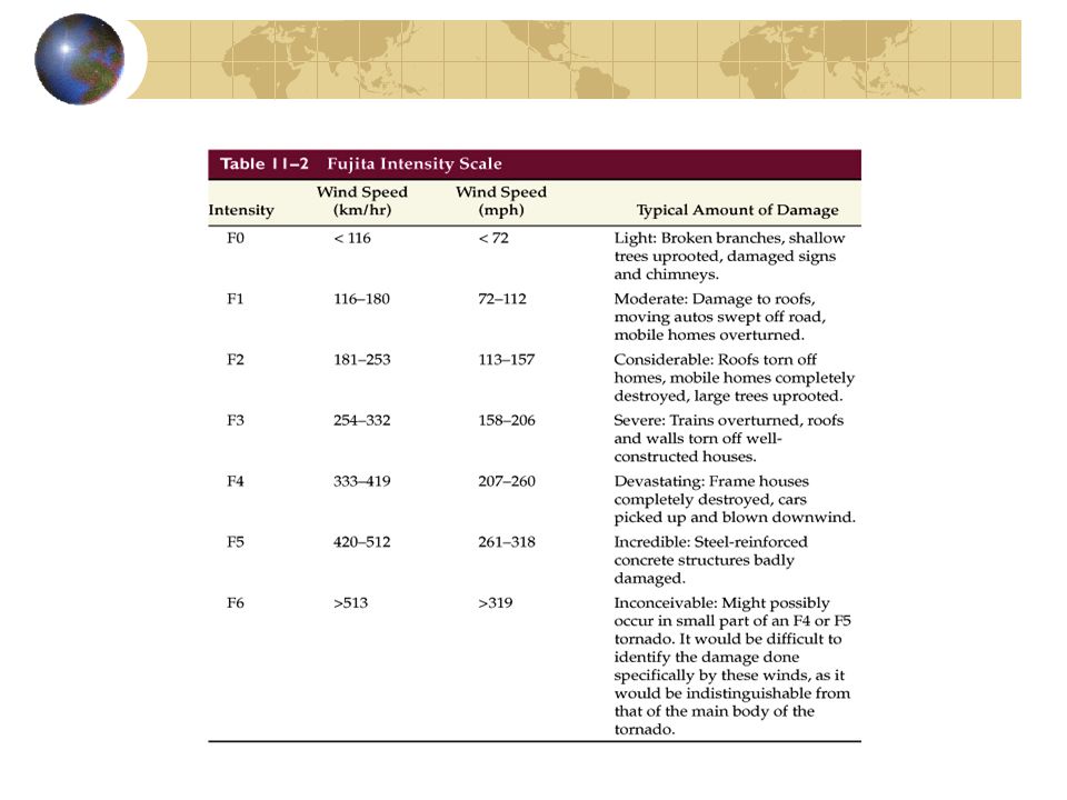
Tornado Damage –Winds, not pressure change, cause the greatest amount of damage –Flying debris causes the greatest amount of injuries –Some tornadoes have multiple suction vortices which may account for rather selective damage patterns –Tornadoes are classified using the Fujita scale which ranks tornadoes based on damage –Of the scale levels (0-5), nearly 3/4 of all tornadoes fall into the weak categories (0-1) while 25% are classified as being strong (2-3), and only 1% are deemed violent (4-5) –Violent tornadoes are capable of nearly catastrophic damage Fatalities –due to their small spatial scales, tornadoes kill relatively few people –On average 760 tornadoes occur in the U.S. yet only 91 people are killed –88% of all tornadoes kill no one –Most fatalities occur in associated with a few large tornadoes rather than with many smaller ones –Only about 1% of all tornadoes are responsible for over 2/3 of all deaths –Mobile homes and autos are the sites of many deaths –The safest place to be during a tornado is in a building basement

34
Watches and Warnings –A weather watch (severe thunderstorm, tornado, etc.) states that atmospheric conditions are favorable for the development of a particular severe weather event –A warning states that severe weather is imminent and precautions should be taken immediately –Because tornadoes develop rapidly and are of short duration, may times a warning may be disseminated only after a tornado has touched down Waterspouts –Similar to tornadoes except that they develop over warm waters and are usually smaller and weaker than tornadoes –Usually form in association with cumulus congestus clouds and although they are over water, the spouts are composed of water vapor condensing into the low pressure area
 states that atmospheric conditions are favorable for the development of a particular severe weather event –A warning states that severe weather is imminent and precautions should be taken immediately –Because tornadoes develop rapidly and are of short duration, may times a warning may be disseminated only after a tornado has touched down Waterspouts –Similar to tornadoes except that they develop over warm waters and are usually smaller and weaker than tornadoes –Usually form in association with cumulus congestus clouds and although they are over water, the spouts are composed of water vapor condensing into the low pressure area")
35
End of Chapter 11 Understanding Weather and Climate 3rd Edition Edward Aguado and James E. Burt

Similar presentations

 and fronts. Describes.>")

 process 3.Ice multiplication.>")


