Download presentation
Presentation is loading. Please wait.

1
Structural Changes In Landfalling Hurricanes COMAP 99 Friday, 17 September 1999 Douglas Schneider NWSFO Raleigh, NC North Carolina State University Dept. of MEAS

2
Objectives : To determine the effects of an upper-level trough on hurricane structure and intensity changes in hurricanes.To determine the effects of an upper-level trough on hurricane structure and intensity changes in hurricanes. To understand the processes that affect a hurricane’s convective sturcture after landfall.To understand the processes that affect a hurricane’s convective sturcture after landfall. To understand the importance of precipitation forecasting in a landfalling tropical cyclone.To understand the importance of precipitation forecasting in a landfalling tropical cyclone.

3
The evolution of Hurricane Opal Formed 130km SSE of Cozumel, Mexico.Formed 130km SSE of Cozumel, Mexico. Moved NW into the Gulf of Mexico.Moved NW into the Gulf of Mexico. Turned and moved NNE; Central pressure dropped to 916mb at 1000 UTC 4 October 1995.Turned and moved NNE; Central pressure dropped to 916mb at 1000 UTC 4 October 1995. Made landfall near Pensacola, Florida at 2200 UTC 4 October with a central pressure of 942mb.Made landfall near Pensacola, Florida at 2200 UTC 4 October with a central pressure of 942mb.

4
The rapid intensification of Opal A warm core eddy was located in the central Gulf of Mexico.A warm core eddy was located in the central Gulf of Mexico. Interaction of Opal with two upper- tropospheric positive PV anomalies. (Molinari et al. 1995)Interaction of Opal with two upper- tropospheric positive PV anomalies. (Molinari et al. 1995) Approached entrance region of a jet located over eastern U.S. (Bosart et al. 1999)Approached entrance region of a jet located over eastern U.S. (Bosart et al. 1999)
Interaction of Opal with two upper- tropospheric positive PV anomalies. (Molinari et al. 1995) Approached entrance region of a jet located over eastern U.S. (Bosart et al. 1999)Approached entrance region of a jet located over eastern U.S. (Bosart et al. 1999).")
5
The rapid weakening of Opal Central pressure of Opal rose 26mb in 12 hours before landfall.Central pressure of Opal rose 26mb in 12 hours before landfall. Average SSTs near land were 26°C as Opal moved away from the warm eddy.Average SSTs near land were 26°C as Opal moved away from the warm eddy. A deep upper-level trough helped to weaken Opal as it approached land.A deep upper-level trough helped to weaken Opal as it approached land.

6
Trough interaction processes that aid TC weakening Dry air advection - decrease latent heat release in the inner core of the storm.Dry air advection - decrease latent heat release in the inner core of the storm. Potential vorticity (PV) structure - can affect the stability in the storm and the outflow above the storm.Potential vorticity (PV) structure - can affect the stability in the storm and the outflow above the storm. Vertical shear - affects PV structure.Vertical shear - affects PV structure.
 structure - can affect the stability in the storm and the outflow above the storm.Potential vorticity (PV) structure - can affect the stability in the storm and the outflow above the storm. Vertical shear - affects PV structure.Vertical shear - affects PV structure..")
7
Role of dry air intrusion Advection of dry air at on the western side of Opal aided in weakening the storm by helping to reduce the latent heat release in the inner core of the storm, leading to the collapse of the inner eyewall.Advection of dry air at on the western side of Opal aided in weakening the storm by helping to reduce the latent heat release in the inner core of the storm, leading to the collapse of the inner eyewall. Strong dry air intrusion in Hurricane Earl led to distinct comma shape.Strong dry air intrusion in Hurricane Earl led to distinct comma shape.

8
Role of potential vorticity Cross sections show low PV at low levels and high PV at upper levels of Opal and high PV to the west associated with the upper-level trough.Cross sections show low PV at low levels and high PV at upper levels of Opal and high PV to the west associated with the upper-level trough. Weakened negative PV anomaly at low levels was caused by reduced convection in the inner core of Opal due to cooler water temperatures and the dry intrusion.Weakened negative PV anomaly at low levels was caused by reduced convection in the inner core of Opal due to cooler water temperatures and the dry intrusion.

9
PV = -( +f)( / p) Potential vorticity is highest in regions where vorticity and static stability are high.
( / p) Potential vorticity is highest in regions where vorticity and static stability are high.")
10
Role of vertical shear PV patterns determine if vertical shear will affect the hurricane (Molinari et al. 1995).PV patterns determine if vertical shear will affect the hurricane (Molinari et al. 1995). Hurricane Elena - Strong negative PV anomaly enhanced outflow which reduced the effect of vertical shear.Hurricane Elena - Strong negative PV anomaly enhanced outflow which reduced the effect of vertical shear. Vertical shear tilts the PV anomaly, which changes the thermal structure of the TC.Vertical shear tilts the PV anomaly, which changes the thermal structure of the TC.
.PV patterns determine if vertical shear will affect the hurricane (Molinari et al. 1995). Hurricane Elena - Strong negative PV anomaly enhanced outflow which reduced the effect of vertical shear.Hurricane Elena - Strong negative PV anomaly enhanced outflow which reduced the effect of vertical shear. Vertical shear tilts the PV anomaly, which changes the thermal structure of the TC.Vertical shear tilts the PV anomaly, which changes the thermal structure of the TC..")
11
Positive vs. negative trough interaction Superposition of a positive PV anomaly can result in intensification when convection is deep and the anomaly is the correct magnitude.Superposition of a positive PV anomaly can result in intensification when convection is deep and the anomaly is the correct magnitude. A strong outflow anticyclone will prevent or minimize the negative trough interaction on a hurricane.A strong outflow anticyclone will prevent or minimize the negative trough interaction on a hurricane.

12
Satellite-derived winds Weak shear over Georges vs. moderate shear over Gulf of Mexico for T.D. 8.Weak shear over Georges vs. moderate shear over Gulf of Mexico for T.D. 8. CIMSS website: http://cimss.ssec.uwisc.edu/tropicsCIMSS website: http://cimss.ssec.uwisc.edu/tropics

13
The evolution of Hurricane Fran Crossed Atlantic Ocean and made landfall at Cape Fear, NC with a central pressure of 954mb.Crossed Atlantic Ocean and made landfall at Cape Fear, NC with a central pressure of 954mb. Damage estimates from Fran in NC were about $2.5 billion.Damage estimates from Fran in NC were about $2.5 billion. A convective cell formed after landfall and organized into a bow echo near Raleigh, causing a large amount of wind damage.A convective cell formed after landfall and organized into a bow echo near Raleigh, causing a large amount of wind damage.

14
Processes that affected the structure of Hurricane Fran Convective cell initiated by frictional convergence after landfall.Convective cell initiated by frictional convergence after landfall. Rear inflow jet and dry air advection were important in the formation of the bow echo and the production of strong downbursts.Rear inflow jet and dry air advection were important in the formation of the bow echo and the production of strong downbursts.

15
Precipitation patterns Large-scale moisture convergence ahead of Fran also helped maintain convection after landfall.Large-scale moisture convergence ahead of Fran also helped maintain convection after landfall. Areas of maximum rainfall located shortly after landfall (frictional convergence) and near Raleigh (convective cell).Areas of maximum rainfall located shortly after landfall (frictional convergence) and near Raleigh (convective cell).
 and near Raleigh (convective cell).Areas of maximum rainfall located shortly after landfall (frictional convergence) and near Raleigh (convective cell)..")
16
Dry intrusion and rear inflow jet A rear inflow jet and mid-level dry layer are important in bow echo formation (Johns and Hirt 1987, Lee et al. 1992)A rear inflow jet and mid-level dry layer are important in bow echo formation (Johns and Hirt 1987, Lee et al. 1992) Wind maximum located at 2.5 km after landfall, decreasing to below 1km as the bow echo forms.Wind maximum located at 2.5 km after landfall, decreasing to below 1km as the bow echo forms. Dry air to the south was advected into Fran by the inflow jet.Dry air to the south was advected into Fran by the inflow jet.
A rear inflow jet and mid-level dry layer are important in bow echo formation (Johns and Hirt 1987, Lee et al. 1992) Wind maximum located at 2.5 km after landfall, decreasing to below 1km as the bow echo forms.Wind maximum located at 2.5 km after landfall, decreasing to below 1km as the bow echo forms. Dry air to the south was advected into Fran by the inflow jet.Dry air to the south was advected into Fran by the inflow jet..")
17
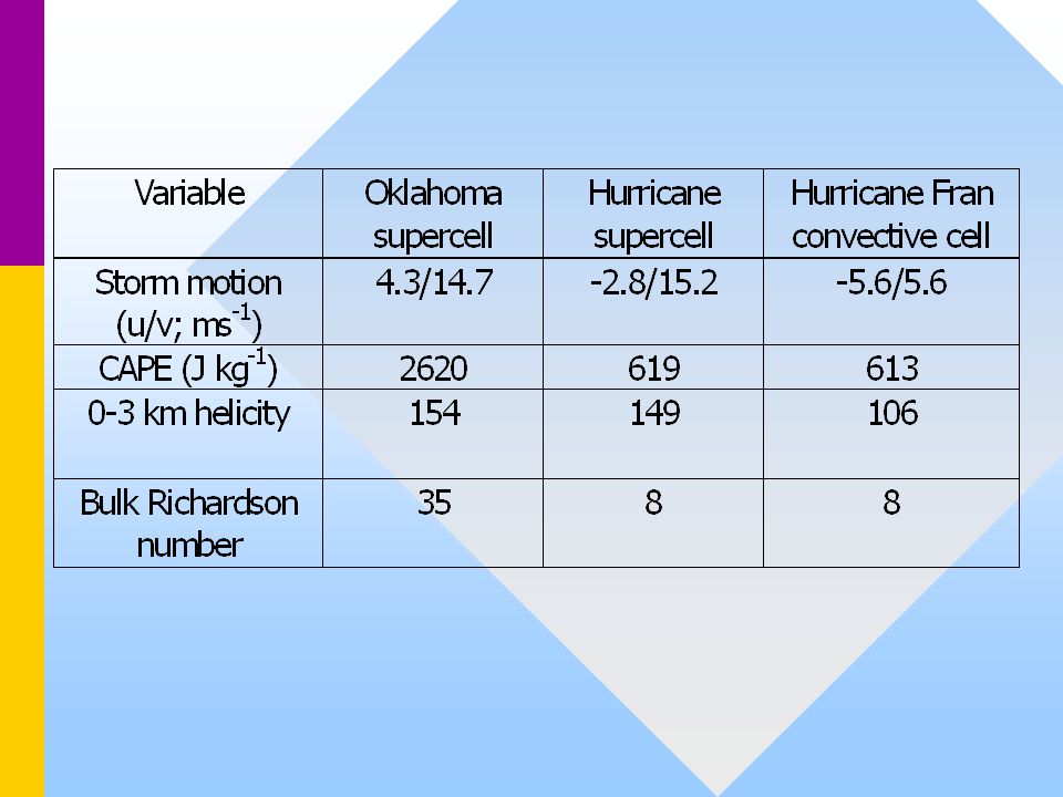
Stability and the storm environment A typical hurricane sounding has deep moisture; Fran soundings have a mid-level dry layer.A typical hurricane sounding has deep moisture; Fran soundings have a mid-level dry layer. McCaul and Weisman (1996) simulated a Midwest supercell and a hurricane supercell.McCaul and Weisman (1996) simulated a Midwest supercell and a hurricane supercell. Stability parameters measured in Fran were generally similar to those of the simulated hurricane supercell.Stability parameters measured in Fran were generally similar to those of the simulated hurricane supercell.
 simulated a Midwest supercell and a hurricane supercell.McCaul and Weisman (1996) simulated a Midwest supercell and a hurricane supercell. Stability parameters measured in Fran were generally similar to those of the simulated hurricane supercell.Stability parameters measured in Fran were generally similar to those of the simulated hurricane supercell..")
19
Importance of rainfall patterns in a hurricane after landfall Inland flooding is responsible for most fatalities in landfalling hurricanes.Inland flooding is responsible for most fatalities in landfalling hurricanes.

20
Forecasting Implications Changing convective patterns after landfall can cause significant damage and loss of life - hurricanes do not disappear after landfall!Changing convective patterns after landfall can cause significant damage and loss of life - hurricanes do not disappear after landfall! More emphasis needs to be placed on post-landfall convective and precipitation patterns in hurricane forecasts, and not just in coastal forecast offices.More emphasis needs to be placed on post-landfall convective and precipitation patterns in hurricane forecasts, and not just in coastal forecast offices.

Similar presentations


 that may contain a stratiform rain region.>")

 Longtao Wu, Hui Su, and Robert Fovell HS3 Science Meeting 2014 1 May 2014.>")

: Complex Lifecycle of an Intense Tropical Cyclone Eyad Atallah, Ron McTaggart-Cowan, Lance Bosart and John Gyakum.>")

 Topic 8: Storm Systems Chris Parkes Rm 455 Kelvin Building.>")


