Download presentation
Presentation is loading. Please wait.

1
Modeling Potential Gray Wolf Habitat in the Grand Canyon Ecoregion Kurt Menke, BEV GIS Paul Sneed, Prescott College Larry Stevens, GCWC Nicole Corbo, GC Wolf Recovery Project Kelly Burke, GCWC Kim Crumbo, GCWC

3
SW HISTORIC DISTRIBUTION 30 wolves killed between 1907-1926 on North Kaibab Plateau Wolves observed on North Rim of Grand Canyon in 1935 and 1948 Last wolf seen in Mogollon Rim area in 1942

4
Based on “course screen”, landscape-scale, spatial modeling of wolf habitat (e.g., Ratti et al. 1999; Wydeven et al. 1998 ) Six biophysical and socioeconomic factors related to wolf sustenance (food) and security (safety) considered (cf. Fuller et al. 1992): –Biophysical Factors = Vegetation cover, water availability, prey densities –Socioeconomic factors = human population, road density, and land status METHODOLOGY
 Six biophysical and socioeconomic factors related to wolf sustenance (food) and security (safety) considered (cf. Fuller et al. 1992): –Biophysical Factors = Vegetation cover, water availability, prey densities –Socioeconomic factors = human population, road density, and land status METHODOLOGY.")
5
Roads can provide access to otherwise undisturbed areas where humans may harass or kill wolves Roads Buffered Interstates 1km (-4) US & State Highways 0.5km (-3) Secondary and Tertiary 0.5km (-2) Primitive 0.5km (-1) Unroaded (+4)
 US & State Highways 0.5km (-3) Secondary and Tertiary 0.5km (-2) Primitive 0.5km (-1) Unroaded (+4)")
6
An important determinant of habitat suitability (or security) for large carnivores is human population density (Merrill et al. 1999) A human population density greater than 12-13 persons/km 2 will limit wolf occupation (Mladenoff et al. 1995) > 12 km2 (-4) 4 – 12 km2 ((+1) < 4 km2 (+4)
 A human population density greater than persons/km 2 will limit wolf occupation (Mladenoff et al. 1995) > 12 km2 (-4) 4 – 12 km2 ((+1) < 4 km2 (+4).")
7
Land Status Favorable land status—defined as public ownership (state and federal) and designated protected areas—can help make a landscape suitable for wolf restoration (Southern Rockies Ecosystem Project 1998) Map shows wide band of federal public lands extending north-south from the Kaibab Plateau to Mogollon Rim (includes three recently designated, large national monuments as well as Grand Canyon National Park)
 and designated protected areas—can help make a landscape suitable for wolf restoration (Southern Rockies Ecosystem Project 1998) Map shows wide band of federal public lands extending north-south from the Kaibab Plateau to Mogollon Rim (includes three recently designated, large national monuments as well as Grand Canyon National Park)")
8
Favorable land status—defined as public ownership (state and federal) and designated protected areas—can help make a landscape suitable for wolf restoration (Southern Rockies Ecosystem Project 1998) Wide band of federal public lands extending north-south from the Kaibab Plateau to Mogollon Rim (includes three recently designated, large national monuments as well as Grand Canyon National Park)
 and designated protected areas—can help make a landscape suitable for wolf restoration (Southern Rockies Ecosystem Project 1998) Wide band of federal public lands extending north-south from the Kaibab Plateau to Mogollon Rim (includes three recently designated, large national monuments as well as Grand Canyon National Park)")
11
Historically, in SW, wolves most often associated with woodlands and montane forests (Groebner et al. 1995; USFWS 1996) Map shows broad band of woodlands-forestlands extending north-south from Kaibab Plateau to the Mogollon Rim, interrupted only by the Grand Canyon and urban areas (e.g., Flagstaff and parts of the Rim country)
 Map shows broad band of woodlands-forestlands extending north-south from Kaibab Plateau to the Mogollon Rim, interrupted only by the Grand Canyon and urban areas (e.g., Flagstaff and parts of the Rim country).")
12
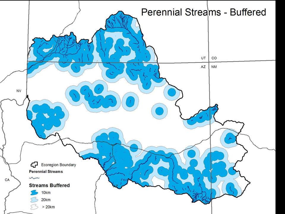
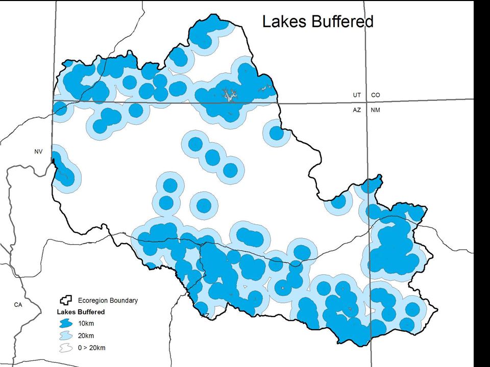
Several studies in SW (USFWS, 1996) and elsewhere (Quinby et al. 1999) have suggested that availability of free water is an important determinant of gray wolf abundance and distribution Map shows that springs and streams (e.g., Colorado River), supplemented by water sources constructed for livestock and wildlife, are widespread throughout GCE
 have suggested that availability of free water is an important determinant of gray wolf abundance and distribution Map shows that springs and streams (e.g., Colorado River), supplemented by water sources constructed for livestock and wildlife, are widespread throughout GCE.")
16
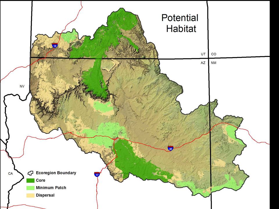
Non-habitat Marginal Suitable

17
Predicted Wolf Densities Assuming that wolf restoration is feasible, must ask how many wolves might the GCE support Following Fuller (1989), very preliminary calculations of predicted wolf density were done for the Arizona portion of the GCE (see following table) Initial carrying capacity research suggests that it is feasible to reintroduce at least 100 gray wolves into the GCE
, very preliminary calculations of predicted wolf density were done for the Arizona portion of the GCE (see following table) Initial carrying capacity research suggests that it is feasible to reintroduce at least 100 gray wolves into the GCE")
20
Thank You…Questions??? Kurt Menke Bird’s Eye View – GIS Services www.BirdsEyeViewGIS.com

Similar presentations