Download presentation
Presentation is loading. Please wait.

1
West Virginia Hospital Service Areas Analysis Using GIS Jennings Starcher GIS Programmer Analyst West Virginia Health Care Authority

2
Overview Introduction Methodology Result Conclusion Future Goals

3
Introduction WVHCA has two primary purposes: Constrain the rising cost of health care Assure reasonable access to necessary health services. Certificate of Need is one of the divisions that oversees these purposes carried out on a daily basis.

4
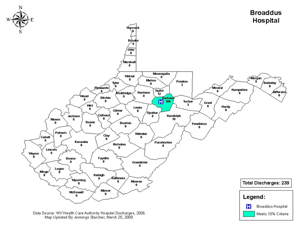
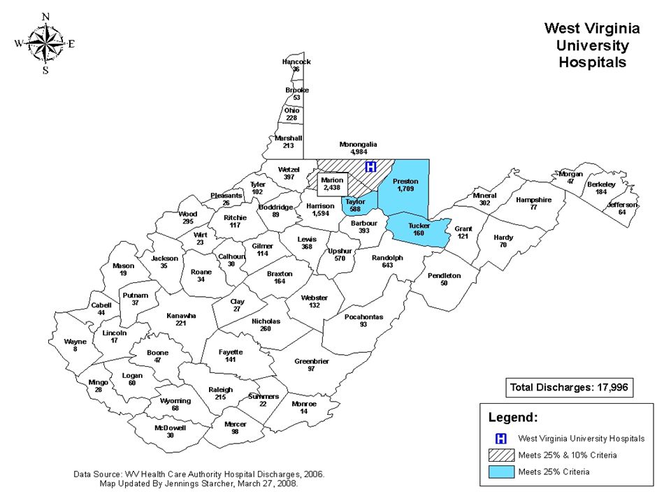
Introduction (cont.) The aim of this project is to illustrate the population-based quantifiable need methodology by examining the 25/10 rule for determining a hospital’s service area. All 62 hospitals in WV were mapped to see which counties each hospital could count as either 25% or 10% service area.

5
Certificate of Need Deals with cost containment measures. Makes sure that services are not being duplicated. Review process of determination of need and financial feasibility. Is one of only 36 states (plus Washington D.C.) to have some form of a CON Process.
 to have some form of a CON Process..")
6
CON Process Health care providers must obtain a CON before they can do any of the following: Adding or expanding health care services. Exceeding the capital expenditure threshold of two million dollars. Obtaining major medical equipment valued at two million dollars or more. Developing or acquiring new health care facilities.

7
25/10 Rule A county wherein at least 25% of the residents rely or will rely on the acute care services in the county of proposal A county which generates at least 10% of the patient load in the county of proposal.

8
Methodology ArcGIS Desktop was main GIS component used. Hospital Discharge By County Spreadsheet West Virginia counties shapefile provided by ESRI

9
First Phase - Highlight Counties that Meet 25/10 Color-coded counties in shapefile that met either the 25% or 10% criteria. 25% = Blue and 10% = Green Highlighted counties that met both 25% and 10% criteria. Striped Black Color

13
Second Phase – Displaying Total Discharges By County Create new database that showed hospital discharges by county. Join the new database file with the West Virginia shapefile to create new shapefile.

16
Results 62 Individual Hospital Maps Hospital Location Total Discharges By County Met 25%, 10% or both 25%/10% classification

22
Conclusion Shows visual representation of which counties a hospital can count as its service area. Serves as a guide for when hospitals submit an application to CON division. Useful for policy-decision makers at HCA.

23
Future Goals Work with CON on developing maps that show discharges for hospitals by zip codes. Work on creating a web-based server that will display all maps. More partnerships with other divisions within agency when it comes to GIS.

24
Presenter Information Jennings Starcher West Virginia Health Care Authority Email: jstarcher@hcawv.orgjstarcher@hcawv.org Phone: (304) 558.7000
")
25
Questions

Similar presentations


 Demonstration Jody Blatt Senior Research Analyst Project Officer, MAPCP Demonstration Medicare Demonstrations.>")


 presents: How to Obtain Protected Health Information (PHI) from an Outside Healthcare.>")


 and Geog. 499 (Python programming) Fall Semester, 2014 Larry.>")

 WV DEP Regulated Community Training Tuesday, December 4 th 2012.>")
>")

 and Other Mapping Tools in VR Programs Todd Sink, Ph.D., Research Specialist II WV Division of Rehabilitation.>")
 Final Regulations.>")


