Download presentation
Presentation is loading. Please wait.

1
Apologies for the lack of work…

2
5 weeks

4
HiGEM1.1 and HiGEM1.2 ‘to add more variability’ 3/4 weeks HiGEM1.1 ≠ HiGEM1.2

5
Subsaturation of mid trop Shouldn’t have negative values in regions of TCs! Unphysical in NWPac! Temp on p level in UM Emanuel (2008) – Large Xm takes longer for TC to reach the point of intensification. Becomes larger with climate change 1/2 weeks
 – Large Xm takes longer for TC to reach the point of intensification. Becomes larger with climate change 1/2 weeks.")
6
Response of Tropical Cyclones to different types of El Niño’s simulated in HiGEM Ray Bell Supervisors: Prof. Pier Luigi Vidale, Dr. Kevin Hodges and Dr. Jane Strachan Trop group 26/3/12

7
Introduction Motivation Socio-economic impacts A better understanding of the ENSO TC relationship could allow for improved seasonal forecasts Research Questions Can HiGEM simulate the expected ENSO TC relationship? (location, frequency and intensity). Can HiGEM simulate different types of El Niño and the response of TCs to these? [Does natural variability mechanisms based on current predictability break down under climate change? I.e. A changing ENSO]
. Can HiGEM simulate different types of El Niño and the response of TCs to these. [Does natural variability mechanisms based on current predictability break down under climate change. I.e. A changing ENSO].")
8
What’s expected? ENSO on NAtl TCs ~ 2x more TCs, 3x more hurricanes in La Nina (Landsea, 1999) ~ 2 or more hurricane landfalls in La Nina 66%. 28% El Nino (Pielke and Landsea, 1999)
 ~ 2 or more hurricane landfalls in La Nina 66%. 28% El Nino (Pielke and Landsea, 1999).")
9
What’s expected? ENSO on NAtl TCs Change in large scale walker circulation in the tropical Pacific. El Niño La Niña Lau and Yang (2002)
.")
10
What’s expected? ENSO on NAtl TCs Change in large scale walker circulation in the tropical Pacific. - Influence the large scale environment from which TCs form Upper level branch of WC extending into the NAtl in El Niño increase the VWS in the MDR region Goldenberg and Sharipo, (1996) Blue = favourable AEW don’t develop as much in El Niño TCs travel more w’ward in La Nina (Kossin et al, 2010)
 Blue = favourable AEW don’t develop as much in El Niño TCs travel more w’ward in La Nina (Kossin et al, 2010).")
11
What’s expected? ENSO on NAtl TCs Change in large scale walker circulation in the tropical Pacific. - Influence the large scale environment from which TCs form Upper level branch of WC extending into the NAtl in El Niño increase the VWS in the MDR region Warm free trop temp wave dynamics increase the stability the NAtl during El Niño (Tang and Neelin, 2004)
.")
12
What’s expected? ENSO on NAtl TCs Vecchi et al (2007) Regions with SST less than the tropical average have a lower MPI
 Regions with SST less than the tropical average have a lower MPI.")
13
What’s expected? ENSO on NAtl TCs Change in large scale walker circulation in the tropical Pacific. - Influence the large scale environment from which TCs form Upper level branch of WC extending into the NAtl in El Niño increase the VWS in the MDR region Warm free trop temp wave dynamics increase the stability the NAtl during El Niño (Tang and Neelin, 2004) Increased mid level dryness with El Niño (Knaff, 1997) Secondary influence – Along with the Atlantic Meridional Mode (AMM) can influence AEW cycle (Bell and Chelliah, 2006; Kossin et al, 2010; Maue et al, 2011) Camrgo et al (2007) believe dynamics are more important than thermodynamics
 Increased mid level dryness with El Niño (Knaff, 1997) Secondary influence – Along with the Atlantic Meridional Mode (AMM) can influence AEW cycle (Bell and Chelliah, 2006; Kossin et al, 2010; Maue et al, 2011) Camrgo et al (2007) believe dynamics are more important than thermodynamics.")
14
What’s expected? ENSO on other basin TCs NWPac Chan and Liu (2004) Wang and Chan (2002)
 Wang and Chan (2002)")
15
What’s expected? ENSO on other basin TCs NEPac Ref ? More intense hurricanes in El Niño (Gray and Sheaffer, 1991) w’ward shift in gensis in El Niño (Camargo, 2008) more less
 w’ward shift in gensis in El Niño (Camargo, 2008) more less.")
16
What’s expected? ENSO on global TCs Camargo et al (2007) ASO JFM NCEP re-an (‘50-’05) GPI
 ASO JFM NCEP re-an (‘50-’05) GPI")
17
Methodology Composites of El Niño and La Nina in HiGEM, ERAinterim and IBTrACS DJF SSTA NINO3.4 > 1 or < -1. - El Niño (82,86,91,94,97,02,09) - La Nina (88,98,99,07)
 - La Nina (88,98,99,07).")
18
HiGEM ENSO TC location El –la tden (HiGEM, ERAint, IBTRACS)
")
19
HiGEM ENSO TC freq

20
Different types of El Niño’s Pacific ‘EPac’ El Niño ‘central’ El Nino Normal La Nina Kim et al (2011)
")
21
Different types of El Niño’s Response on TC cyclones Favourable TC landfall Kim et al (2011) Kim et al (2009) Cf. Lee et al (2010)
.")
22
2 types of ENSO in HiGEM CT el DJF SSTa norm NINO3 > 1 & NINO3>NINO4 WP el DJF SSTa norm NINO4 > 1 & NINO4>NINO3 Kug and Ham (2011)
")
23
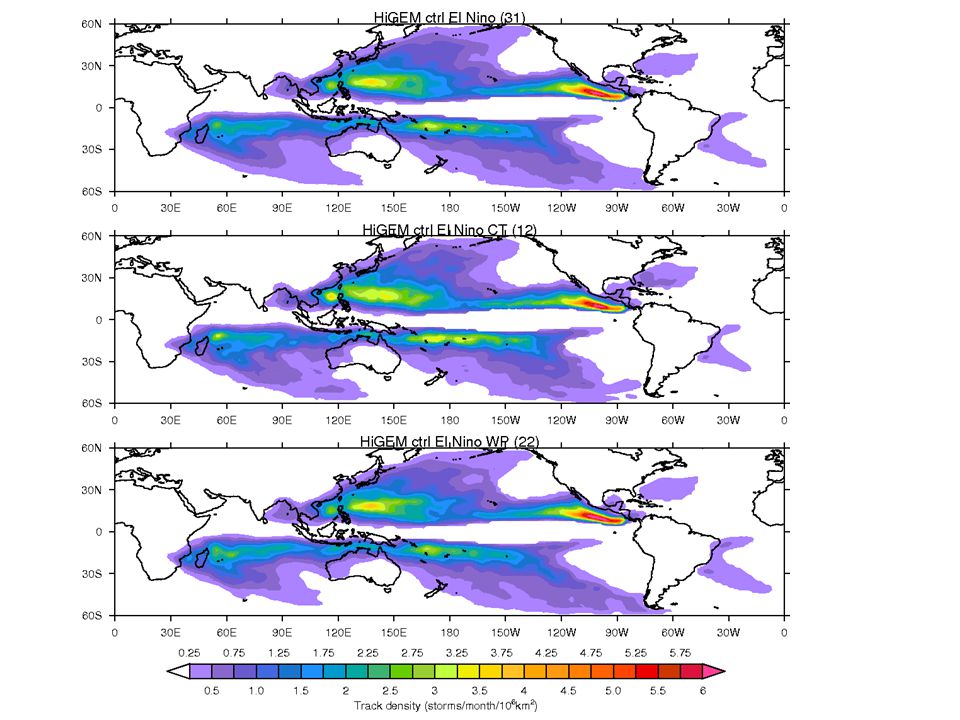
HiGEM Different types of El Niño’s

25
Shen (2000) Emanuel Potential intensity Vs^2= (Ck/Cd)*(Ts/To)*(CAPE*-CAPEb) ko=f(T,p,RH))
 Emanuel Potential intensity Vs^2= (Ck/Cd)*(Ts/To)*(CAPE*-CAPEb) ko=f(T,p,RH))")
26
AMM Atlantic Meridional Mode, represented as the leading Maximum Covariance Analysis (MCA) mode in the tropical Atlantic. Top: Regression maps of the MCA leading mode sea surface temperature (SST) normalized expansion coefficients on SST and 10-m wind vectors. (Chang and Vimont, 2004)
 normalized expansion coefficients on SST and 10-m wind vectors. (Chang and Vimont, 2004).")
27
GPI GPI=|10^5*n|^(3/2) * (RH/50)^3 * (1+0.1Vs) * (PI/70)
 * (RH/50)^3 * (1+0.1Vs) * (PI/70)")
28
ASO JFM

29
Different types of El Niño’s Response on TC cyclones Pradhan (2011) OLRa JJA
 OLRa JJA")
32
Discussion ENSO NAtl TC teleconnection in models Shaman and Maloney (2011) – Limited by models not capturing the mean state and variability of TCs in the NAtl. - Poor simulation of ENSO - Poor simulation of response (large scale forcing.) - VWS and PI are poorly simulated.
 - VWS and PI are poorly simulated..")
33
What’s expected? ENSO on global TCs Camargo et al (2007) ASO JFM NCEP re-an (‘50-’05) GPI
 ASO JFM NCEP re-an (‘50-’05) GPI")
34
HiGEM Different types of El Niño’s

Similar presentations


 suggest greater.>")


 –Tropical Pacific: El Nino/Southern Oscillation –Southern Ocean.>")
