Download presentation
Presentation is loading. Please wait.

1
SWICA 2 FIELD TRIP to the Northwest Yucatan Peninsula 2-3 April, 2003 Eugene Perry* & Julia Pacheco Trip Leaders *e-mail: t60ecp1@wpo.cso.niu.edu Photos & field assistance: Richard Socki and Charles Galindo

2
Consequence of 2: Groundwater flows preferentially through faults and fracture systems. In particular, there is extensive flow through the Cenote Ring. Characteristics of the Northern Yucatan Peninsula 1)Shallow Shelf 2)Flat-lying, homogeneous, porous, permeable carbonate rocks 3) Almost no surface drain- age 4) Extensive saline intrusion 5) Little soil
Shallow Shelf 2)Flat-lying, homogeneous, porous, permeable carbonate rocks 3) Almost no surface drain- age 4) Extensive saline intrusion 5) Little soil.")
3
NASA PIA03379 Field Trip begins here Relief image showing Cenote Ring Ends here

4
Field Trip begins on the evening of 2 April Leave Merida 5:15 PM. Arrive Celestun 7:15 PM. We will stay at the Hotel Maria del Carmen, a Modest but Clean and Comfortable Hotel right on the Beach. Dinner 7:30 PM 8:30-9:45 PM Lecture.

5
Celestun Dead mangrove forest behind town A Fishing Village on a Sandspit

6
7:30 AM, 3 April. Embark for Celestun Estuary. Bring a hat! Continental Breakfast served enroute. The Estuary receives groundwater flowing through the western arm of the Cenote Ring. Mixing of this groundwater with seawater arguably produces an aggressive water capable of dissolving aragonite and high-Mg calcite in the shell-derived sand brought by westward-flowing longshore current (Perry et al, 2003). Thus, chemical erosion is probably an important mechanism maintaining the estuary. Groundwater here is confined. We will visit one or more springs in the Estuary. Groundwater under positive head also enters the Estuary through the sand and silt in the bottom. Flamingo sightings are likely but not guaranteed. [Photo courtesy of Ken Knezick-Island Dreams: http://www.islandream.com/phot0302b.htm]
. Thus, chemical erosion is probably an important mechanism maintaining the estuary. Groundwater here is confined. We will visit one or more springs in the Estuary. Groundwater under positive head also enters the Estuary through the sand and silt in the bottom. Flamingo sightings are likely but not guaranteed. [Photo courtesy of Ken Knezick-Island Dreams:")
7
Kopoma water is typical of water flowing westward in the Cenote Ring. When mixed with seawater the resulting water is capable of dissolving calcite and aragonite. Water seeping through bottom silt of the estuary, when mixed with estuarine surface water, forms a mixture at equilibrium with aragonite.

8
[Photo courtesy of Ken Knezick-Island Dreams http://www.islandream.com/phot0302a.htm] Spoonbill

9
North Coast Confining Layer (Numbers are water table elevations above mean sea level (m).) This diagram (from Perry et al, 1989) shows the zone confined by a caliche layer north of Merida. At Celestun the coastal confined zone is about twice as wide.

10
Explanation: 1)Water table (WT) is closely controlled by sea level. 2) WT reaches ground surface near coast. 3) Evaporating water precipitates CaCO 3. 4) Cracks formed in caliche layer are immediately healed. Layer becomes impermeable. Saline intrusion From Perry et al, 1989
 WT reaches ground surface near coast. 3) Evaporating water precipitates CaCO 3. 4) Cracks formed in caliche layer are immediately healed. Layer becomes impermeable. Saline intrusion From Perry et al,")
11
This is a general schematic for the north coast. The Celestun Estuary is different in that, at least in places, bottom silt rests directly on permeable corroded and punky limestone. The caliche confining layer is present beneath the town, and groundwater beneath the Estuary is confined.

12
Double Cenote Ring Quarry Dzaptun Ha Old Water Works Celestun Longshore Current

13
9:30. Disembark at Estuary bridge. (Note that the only formal “rest(?) room” facilities for a long time are at the Embarcadero! Drive 11.2 km east to the old Celestun municipal waterworks. Here we can see that the entire water supply for Celestun was pumped (until about the year 2000) from a single well open for only a meter or so in the highly permeable limestone & beneath about a meter of confining caliche. Groundwater here responds directly to tides and, except for slightly higher NaCl content is similar to groundwater from Kopoma (also on the Cenote Ring). Frequently there is a layer of surface water above the caliche layer. When present, it has a completely different chemistry from the well water.
 room facilities for a long time are at the Embarcadero. Drive 11.2 km east to the old Celestun municipal waterworks. Here we can see that the entire water supply for Celestun was pumped (until about the year 2000) from a single well open for only a meter or so in the highly permeable limestone & beneath about a meter of confining caliche. Groundwater here responds directly to tides and, except for slightly higher NaCl content is similar to groundwater from Kopoma (also on the Cenote Ring). Frequently there is a layer of surface water above the caliche layer. When present, it has a completely different chemistry from the well water..")
14
9:55(+/-) Head east for 4 km (on the only possible road) to a dirt road on the south side of the highway. Turn right and proceed to the end of this road. (The clue to the turnoff is that a high tension power line crosses the main road here.) This is Cenote Dzaptun Ha located at N20°51'01". W90°14'08." It now supplies water for Celestun. Dzaptun Ha is more than 30 m deep. Like many cenotes, it has a dome- like ceiling below the caliche cap, and it has a rubble pile from collapse material in the center. It extends below the saline interface. (See chemical profile.) Although Dzaptun Ha is about 20 km from the coast, it responds to tides. In fact, it shows a complex behavor, which, although not analyzed, is consistent with a shallow response to tides at the nearest coast and a deeper response to tides further north where the Cenote Ring encounters the coast.
 This is Cenote Dzaptun Ha located at N20° W90° It now supplies water for Celestun. Dzaptun Ha is more than 30 m deep. Like many cenotes, it has a dome- like ceiling below the caliche cap, and it has a rubble pile from collapse material in the center. It extends below the saline interface. (See chemical profile.) Although Dzaptun Ha is about 20 km from the coast, it responds to tides. In fact, it shows a complex behavor, which, although not analyzed, is consistent with a shallow response to tides at the nearest coast and a deeper response to tides further north where the Cenote Ring encounters the coast..")
15
10:20 Head for small quarry in caliche near Celestun-Chunchucmil crossroad (20.8 km east of the Celestun Estuary bridge). In this quarry it is possible to get a close look at the caliche confining layer (which is what was quarried). Although subterranean erosion is less vigorous here than elsewhere along the coast, it is possible to see how cementation by seasonal evaporation of groundwater maintains the coherence of the impermeable caliche layer.
. Although subterranean erosion is less vigorous here than elsewhere along the coast, it is possible to see how cementation by seasonal evaporation of groundwater maintains the coherence of the impermeable caliche layer..")
16
Groundwater in this quarry has a tidal fluctuation, but, in contrast to Dzaptun Ha, it is directly correlated with the tide at Celestun.

17
Top Bottom (uneven surface) Caliche Thickness
 Caliche Thickness")
18
Brecciated caliche (detail) Brecciated caliche
 Brecciated caliche")
19
Caliche

20
11:00 Drive south on road to Chunchucmil. At 5.1 km we pass a small, shallow cenote that opens into a cave at one end. This cenote also responds to tides.

21
At 24.9 km from Celestun road, we pass through the small village of Chunchucmil with its hacienda and satellite cottages. This hacienda is more or less typical of estates in the heyday of the henequen boom.

22
At Chunchucmil, we turn east toward Maxcanu. Beyond the village chosas (like this one) we come to a large, unrestored Maya city. A good question (possibly related to climate and sea level change) is: Why was it built here? As we drive east, notice the conspicuous ridge that will appear on the right. This is the Sierrita de Ticul. It marks a fault, upthrown to the south, that is a major conduit for groundwater.
 we come to a large, unrestored Maya city. A good question (possibly related to climate and sea level change) is: Why was it built here. As we drive east, notice the conspicuous ridge that will appear on the right. This is the Sierrita de Ticul. It marks a fault, upthrown to the south, that is a major conduit for groundwater..")
23
12:00. Arrive at Merida-Campeche highway. Seek out a PEMEX station near Maxcanu for attention to bodily functions. Proceed to Grutas Chalcehtok, struggling not to get lost on new highway. The hope is to arrive here by 12:30 for lunch beside a cave system in the Sierrita de Ticul. This cave would be a cenote if sea level were higher. Like many Yucatan caves, Grutas Chalcehtok have had a long period of human occupation.

24
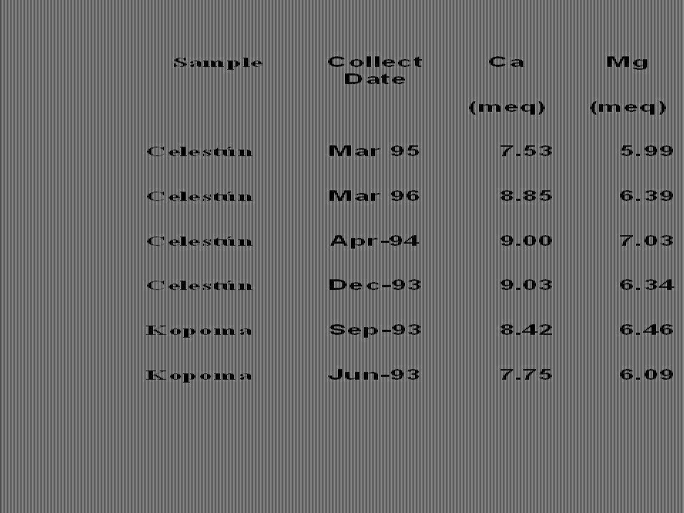
Leave the Grutas about 13:15. There are two optional stops south of Merida:1) in downtown Kopoma, essentially on the Cenote Ring, we can compare the chemistry of the groundwater to that at the old Celestun well. Both are similar, with high sulfate/Cl ratios (an excellent groundwater tracer). This stop depends on whether we can set up portable equipment for rapid chemical analysis (otherwise see Table 1). 2) Cenote Chen Ha, on the Merida highway 5.2 km north of Kopoma is typical of the cenotes in this part of the Cenote Ring. A stop here depends on whether we are on schedule Early afternoon is the hottest part of the tropical Yucatecan day. There will be plenty of cold drinks and bottled water, but this is when the farmers come home for a nap. That's another reason that some afternoon stops are optional. A few kilometers to the east is Hacienda Yaxcopoil, now a tourist attraction. This is where an international consortium cored a 1.5 km hole into (and perhaps through) Chicxulub impact breccia.
 in downtown Kopoma, essentially on the Cenote Ring, we can compare the chemistry of the groundwater to that at the old Celestun well. Both are similar, with high sulfate/Cl ratios (an excellent groundwater tracer). This stop depends on whether we can set up portable equipment for rapid chemical analysis (otherwise see Table 1). 2) Cenote Chen Ha, on the Merida highway 5.2 km north of Kopoma is typical of the cenotes in this part of the Cenote Ring. A stop here depends on whether we are on schedule Early afternoon is the hottest part of the tropical Yucatecan day. There will be plenty of cold drinks and bottled water, but this is when the farmers come home for a nap. That s another reason that some afternoon stops are optional. A few kilometers to the east is Hacienda Yaxcopoil, now a tourist attraction. This is where an international consortium cored a 1.5 km hole into (and perhaps through) Chicxulub impact breccia..")
25
Afternoon stops will concentrate on showing the effects of development. We will travel to Chicxulub Pueblo, center of the eponymous impact crater, which is about 60 km north-northeast of Kopoma, arriving about 15:00. If possible we will stop briefly at a chicken or hog "factory." Whether we stop or not, we will pass a number of these large waste-producing Facilities, a few of which are visible from main highways. From Chicxulub we will drive to the coast to see coastal development, which involves causeway construction, filling in of the saline swamp, and destruction of the caliche confining layer. A few salt pans are still in operation, continuing an industry first developed by the Maya. Final stop will be at Yucalpeten, the first, and largest, of a number of dredging operations undertaken to produce safe harbors for fishing boats.

26
Chicxulub builds a bull ring in preparation for its annual festival.

29
Perry, E., Swift, K., Gamboa, J., Reeve, A., Sanborn, R., Marin, L., and Villasuso, M., 1989, Geologic and environmental aspects of surface cementation, north coast, Yucatan, Mexico: Geology, v. 17. p. 818–821. Perry, E., Marin, L., McClain, J., and Velazquez, G., 1995, Ring of cenotes (sinkholes), northwest Yucatan, Mexico: Its hydrogeologic characteristics and possible association with the Chicxulub impact crater: Geology, v. 23, p. 17–20. Back, William, Hanshaw, Bruce B., Comparison of chemical hydrogeology of the carbonate peninsulas of Florida and Yucatan, Journal of Hydrology, 10 (4), p. 330-368, illus. (incl. geol. sketch map), 1970. Back, William (U. S. Geol. Surv., Reston, VA, United States), Hanshaw, Bruce B., Herman, Janet S., Van Driel, J. Nicholas, Differential dissolution of a Pleistocene reef in the ground-water mixing zone of coastal Yucatan, Mexico,Geology, 14, p. 137-140, illus. incl. 1 table, sketch map, 25 refs, 1986.
, northwest Yucatan, Mexico: Its hydrogeologic characteristics and possible association with the Chicxulub impact crater: Geology, v. 23, p. 17–20. Back, William, Hanshaw, Bruce B., Comparison of chemical hydrogeology of the carbonate peninsulas of Florida and Yucatan, Journal of Hydrology, 10 (4), p , illus. (incl. geol. sketch map), Back, William (U. S. Geol. Surv., Reston, VA, United States), Hanshaw, Bruce B., Herman, Janet S., Van Driel, J. Nicholas, Differential dissolution of a Pleistocene reef in the ground-water mixing zone of coastal Yucatan, Mexico,Geology, 14, p , illus. incl. 1 table, sketch map, 25 refs,")
30
Perry, E.C., Velazquez-Oliman, G., and Marin, L. E. (2002) The Hydrogeochemistry of the Karst Aquifer System of the Northern Yucatan Peninsula, Mexico. International Geology Review, 44, p. 191-221. Pope, K. O.; Rejmankova, E.; and Paris, J. F. (2001) Spaceborne imaging radar-C (SIR-C) observations of groundwater discharge and wetlands associated with the Chicxulub impact crater, northwestern Yucatan Peninsula, Mexico. GSA Bulletin, 113, pp. Ward, W. C.; Weidie, A. E.; and Back, W., 1985, Geology and hydrogeology of the Yucatan and Quaternary geology of northeastern Yucatan Peninsula: New Orleans Geological Society, 160 p
 The Hydrogeochemistry of the Karst Aquifer System of the Northern Yucatan Peninsula, Mexico. International Geology Review, 44, p Pope, K. O.; Rejmankova, E.; and Paris, J. F. (2001) Spaceborne imaging radar-C (SIR-C) observations of groundwater discharge and wetlands associated with the Chicxulub impact crater, northwestern Yucatan Peninsula, Mexico. GSA Bulletin, 113, pp. Ward, W. C.; Weidie, A. E.; and Back, W., 1985, Geology and hydrogeology of the Yucatan and Quaternary geology of northeastern Yucatan Peninsula: New Orleans Geological Society, 160 p.")
Similar presentations


, in which the topography is chiefly formed by the dissolving.>")


 water from the highest to the lowest point.>")


 Zone of Aeration.>")

