Download presentation
Presentation is loading. Please wait.

1
Chapter 10 and 11 (pgs 154 – 181) Environmental Science
Aquatic Biomes Chapter 10 and 11 (pgs 154 – 181) Environmental Science
 Environmental Science.")
2
CHAPTER 10: FRESHWATER BIOMES

3
10.1 AQUATIC BIOMES Water covers 70% of Earth’s surface.
Aquatic habitat: habitat in which organisms live on or in water. Most important factors: 1. Amount of dissolved salts. 2. Depth

4
Salinity Salinity: amount of dissolved salts in a sample of water.
Allows us to divide water into 2 groups: 1. Saltwater-30 parts per thousand. 2. Freshwater-0.5 parts per thousand. Brackish water-in the middle. Common where freshwater meets the ocean.

5
Saltwater

6
Freshwater

7
Brackish water

8
Hypersaline Lakes

9
Depth Directly related to amount of sunlight that reaches the bottom of body of water. Sunlight determines the plants that grow on the bottom. Bodies of water can be divided into depth zones: Photic Zone Aphotic Zone Benthic Zone

10
Depth Zones Diagram

11
Benthic Zone: floor of a body of water.
Photic Zone: top layer of water that receives enough sunlight for photosynthesis to occur. About 100 meters in open ocean. Aphotic Zone: below the photic zone. Sunlight never reaches here. Only found in oceans and very deep lakes. Benthic Zone: floor of a body of water.

12
CHECK FOR UNDERSTANDING:
What characteristic distinguishes the photic zone from the aphotic zone? How is salinity determined and measured? Suppose a friend wants to set up an aquarium and discovers that saltwater fish are more attractive, but a freshwater aquarium is easier to maintain. Your friend decides to set up a freshwater aquarium, but buys some saltwater fish to place in it. Predict what the result of this decision would be and why.

13
10.2 STANDING-WATER ECOSYSTEMS
Freshwater biomes: 1. Standing-water ecosystems Lakes and ponds, wetlands, bogs, swamps, marshes 2. Flowing-water ecosystems

14
Lake Deepest standing water; may have aphotic zone; may be fed by underground aquifers. Main producers: floating algae and benthic plants along shoreline.

15
Pond Light reaches benthic zone; fed by rainfall; may be seasonal.
Main producers: plants and algae that grow on bottom.

16
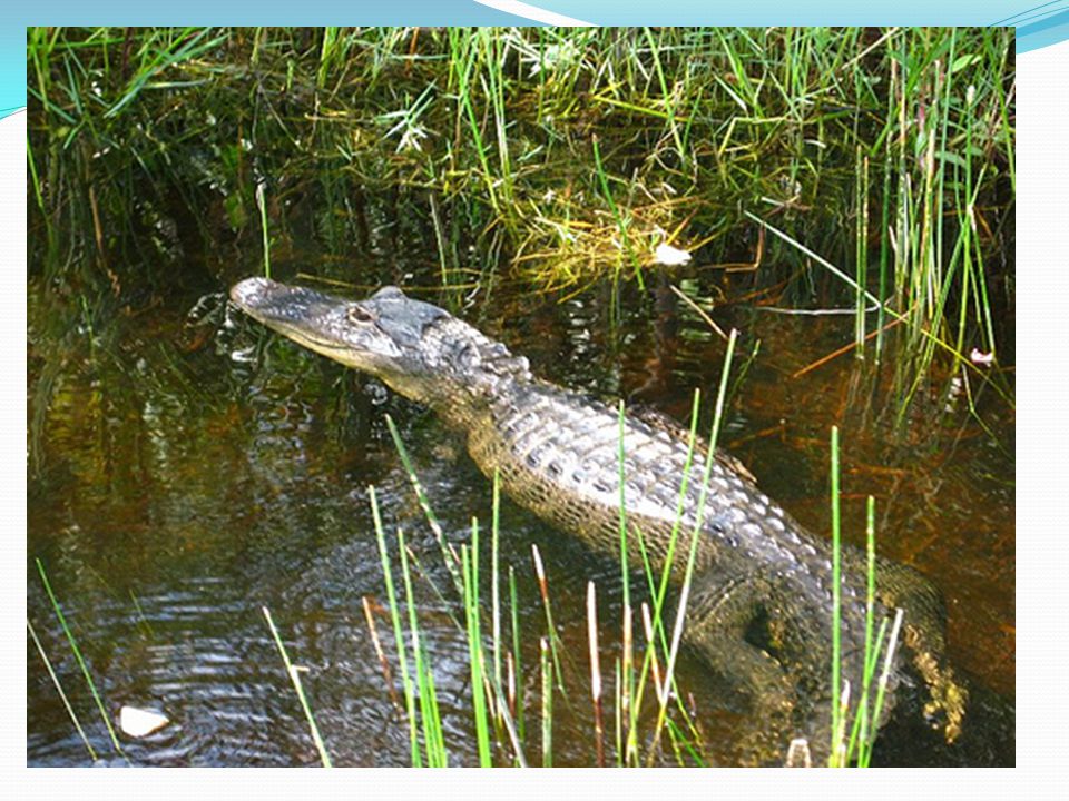
Marsh Very shallow with land occasionally exposed; soil saturated; very low oxygen in water; salinity may vary (Florida Everglades) Plants: roots under water, leaves above water; grasses, cattails, rushes; ducks, waterfowl, benthic animals common.

17
Swamp Poor drainage (land soaked with water); along low streambeds and flat land. Large trees and shrubs; plants grow in muddy, oxygen-poor soil; cypress trees, willow, dogwood.

18
Bog Inland wetland with little inflow or outflow; soil acidic; decay slow. Sphagnum moss dominant; decayed moss accumulates.

19
Standing-Water Organisms
Upper level of water. Plankton: microorganisms that float on the surface of the water. 1. Phytoplankton: plankton that carry out photosynthesis. (producers) 2. Zooplankton: plankton that do not carry out photosynthesis. (consumers) Benthic level Scavengers Food chain: phytoplanktonzooplanktonsmall fish large fish
 2. Zooplankton: plankton that do not carry out photosynthesis. (consumers) Benthic level. Scavengers. Food chain: phytoplanktonzooplanktonsmall fish large fish.")
20
Wetlands Wetlands: ecosystems in which the roots of plants are submerged under water at least part of the year. Examples: marshes, swamps, bogs. Soil soaked with water; low in oxygen. Water may be fresh, brackish, salt water, or flowing. Detoxify chemicals in the water that passes through them. Breeding, feeding, resting grounds for waterfowl. Flood protection Refill aquifers

21
Human Activity Destroy because we don’t like the animals there.
It is not attractive to us. Like waterfront view.

22
The Florida Everglades
Used to span 160 km from Lake Okeechobee to tip of Florida. Maximum water depth 2 meters. Wet season from May-October. Much drained to create farmland.

23
Map of Florida Everglades…

25
CHECK FOR UNDERSTANDING:
Where would you be likely to find benthic organisms in an aquatic ecosystem? What is the difference between the role of phytoplankton and the role of zooplankton in an aquatic food web?

26
10.3 FLOWING-WATER ECOSYSTEMS

27
Stream Organisms Adapted to living in flowing-water.
Insects have hooks to grab hold of plants. Fish “smell” chemicals in the water to return to old breeding grounds.

28
Stream Flow Flow to ocean because of gravity.
Source (head) of stream: where stream begins. Headwater- water near the stream source. Sediments: small particles that settle to the bottom of a body of water. Accumulate on bottom; provide place for plant roots to grow. Slow flow of water. Cause stream to change course over time.
 of stream: where stream begins. Headwater- water near the stream source. Sediments: small particles that settle to the bottom of a body of water. Accumulate on bottom; provide place for plant roots to grow. Slow flow of water. Cause stream to change course over time.")
29
CHECK FOR UNDERSTANDING:
What condition encourages sediments to settle out of the flowing water in a stream? Why are there fewer organisms in the headwater of a stream than further downstream?

30
CHAPTER 11: THE MARINE BIOME

31
11.1 THE WORLD OCEAN The water between the continents.
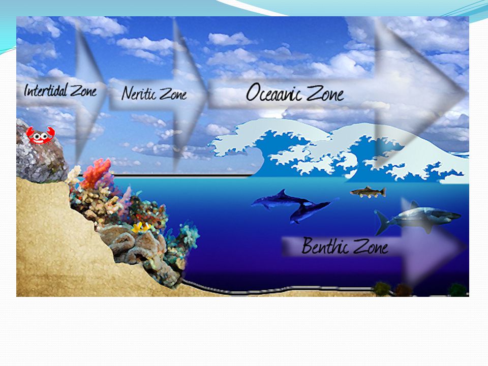
All oceans are connected. Zones based on depth: Photic zone Aphotic zone Benthic zone Zones based on distance from shore: Intertidal zone Neritic zone Oceanic zone

32
Zones of the ocean diagram:

34
The Oceanic Zone Oceanic Zone: open ocean; the largest zone, making up more than 90% of the surface area of the world ocean. 500 – 11,000 meters below ocean surface. Not much sunlight. Photic Zone Phytoplankton are main producers. Aphotic Zone Many organisms feed on what drifts down. Detritus: tiny pieces of dead organic material that are food for organisms at the base of the aquatic food web.

35
Ocean Water Near equator Near poles
Warmer, more saline, higher mineral content. Near poles Less salty, denser. Ocean currents: characteristic patterns the water flows in. Driven by wind.

36
CHECK FOR UNDERSTANDING:
What is detritus made of, and why is it important to deep sea organisms? Why does the oceanic zone have no plants? What are the producers of the open ocean?

37
11.2 NERITIC ZONES Continental Shelf: shallow border that surrounds the continents. Area between the shore and about 500 meters below the surface of the water. Neritic Zone: region between the continental shelf and the surface of the water. In the photic zone. Reefs and estuaries.

38
Coral Reefs Reef: natural structure built on a continental shelf.
Made from products of reef organisms. In warm, tropical waters. Breeding and feeding grounds for many fish. Protect shoreline from erosion. VERY diverse.

39
Reef made of: Humans harm reefs:
Calcium carbonate skeletons of corals. Symbiotic relationship between coral and alga inside tissue of coral. Coral have polyp-shaped bodies and stinging cells. Humans harm reefs: Blast with dynamite. Harvested and sold for jewelry. Fish used in aquariums. Water pollution

40
Picture of a coral

41
Estuaries Estuary: region of water in which a freshwater source, usually the mouth of a river, meets salt water from the ocean. Brackish water.

42
Picture of estuary

43
Neritic Zone Productivity
Factors: Availability of sunlight allows photosynthesis. High in mineral nutrients. Tides

44
CHECK FOR UNDERSTANDING:
Where in the ocean does the neritic zone begin and end? Some types of ecosystems recover from damage more quickly than others. Would you expect coral reefs to recover quickly from the types of damage described in this section? Why or why not?

45
11.3 INTERTIDAL ZONES Intertidal zone: along the shoreline; alternates between periods of exposure and periods of submersion twice a day. Organisms must survive: submersion, exposure, pounding by surf. Surrounded by wetlands.

46
Salt Marshes

47
Flat, muddy wetlands that often surround estuaries, bays and lagoons.
Influenced by tides. Support migratory bird populations. Support ocean ecosystem. Form when streams flow into waters of estuaries or other shallow, neritic waters. Slowing of waters cause sediments to be deposited in mouth of stream. Sediments build up over time, forming a delta.

48
Subsidence: delta sinks under the water due to the weight of the accumulated sediments.

49
Mangrove Swamps

50
Coastal wetlands that occurs only in warm climates.
Mangrove-woody plant that is either a tree or a shrub. Roots that emerge from water. Very little dissolved oxygen.

51
CHECK FOR UNDERSTANDING:
Why are salt marshes considered part of the intertidal zone?

Similar presentations


 Depth.>")


