Download presentation
Presentation is loading. Please wait.

1
Section 22 Online Register

2
Unregulated Landfills 5. (1) Each local authority shall identify by 30 June 2009 all closed landfills within its functional area and for such purposes shall have regard to the methodology set out in Appendix 1 of the Code of Practice. 6. (1) Subject to Regulation 6(2), each local authority shall carry out a Risk Assessment in respect of all closed landfills identified pursuant to Regulation 5(1) and for such purposes shall have regard to the Code of Practice. (2) The Risk Assessment shall evaluate the priority to be assigned to the closed landfill site in accordance with the Risk Classification system set out in Chapter 4.3.3 of the Code of Practice. IDENTIFY ASSESS RANK
 Each local authority shall identify by 30 June 2009 all closed landfills within its functional area and for such purposes shall have regard to the methodology set out in Appendix 1 of the Code of Practice. 6. (1) Subject to Regulation 6(2), each local authority shall carry out a Risk Assessment in respect of all closed landfills identified pursuant to Regulation 5(1) and for such purposes shall have regard to the Code of Practice. (2) The Risk Assessment shall evaluate the priority to be assigned to the closed landfill site in accordance with the Risk Classification system set out in Chapter of the Code of Practice. IDENTIFY ASSESS RANK.")
3
Project Background Code of Practice created by EPA Office of Environmental Enforcement, 2007 Includes a section on how to use GIS data to assign a risk ranking score to a site

4
GIS Model In 2008, the method in the Code of Practice was worked into a desktop pilot using ArcGIS Modelbuilder (Jason Larkin, EPA)
")
5
Desktop Issues nStability of modelbuilder nSize of model nCompatibility of modelbuilder with ArcGIS Server (9.2) nSpeed of deployed model
 nSpeed of deployed model")
6
Landfill WebGIS, Phase 1 and 2 Phase 1 – develop an ArcGIS Solution nContracted to Compass Informatics, September 2008 nDeploy an ArcGIS solution to capture and risk assess landfill boundaries nAllow GIS data to complement user data from surveys nDevelop standardised reports for users

7
Landfill WebGIS, Phase 1 and 2 Phase 2 – integrate and deploy Section 22 Register nContracted to Compass Informatics, April 2009 nLink the ArcGIS solution with existing data capture website nCreate a “wizard” like solution, that steps users through data collection nComplement users own data with GIS, giving them the choice to use either option

8
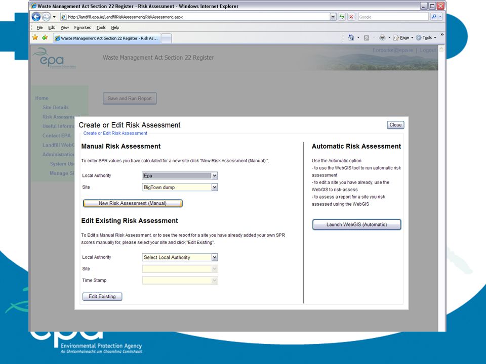
Whistle Stop Tour http://landfill.epa.ie/LandfillRisk Assessment/

10
Step 1: Identify

19
Advantages nSingle solution – not insistent on use of GIS nData dissemination reduced nCommon data is used, no chance of out of synch versions nOnus removed from user to carry out desktop GIS assessments nUser controls data – can overwrite any aspect of the automated risk assessment after a walkover survey nDual approach possible – user can create an automated risk assessment but still use the manual version

20
Post Launch Feedback nInternet Explorer 8 – issues with IMS and Server sites nSecurity – internet explorer security settings, web marshalling nPop-up blockers n“Intuitive-ness” – hard to be perfect

21
Next steps nExtractive Waste Facilties (Quarries) Register nAll Local Authorities will have to register extractive waste facilties by December 2009 nExtractive Waste “dot” is mandatory, polygon of site, monitoring points, discharge points optional nRisk assessment module will be added nLearn from Section 22 Register and improve
 Register nAll Local Authorities will have to register extractive waste facilties by December 2009 nExtractive Waste dot is mandatory, polygon of site, monitoring points, discharge points optional nRisk assessment module will be added nLearn from Section 22 Register and improve")
Similar presentations