Download presentation
Presentation is loading. Please wait.

1
Mining For Lost Treasure National Geospatial Data Clearinghouse Archibald Warnock U.S. Federal Geographic Data Committee A/WWW Enterprises

2
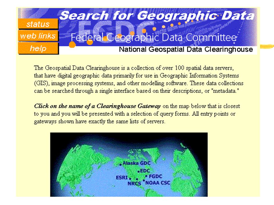
What is Clearinghouse? zDistributed service to locate geospatial data based on their characteristics expressed in metadata zClearinghouse allows one to pose a query of all or a portion of the community in a single session zLike a spatial AltaVista

3
Components of Clearinghouse zThere are three functional areas that interact to create the Clearinghouse: yMetadata preparation and indexing yMetadata service yUser Access via Gateway forms

4
Clearinghouse Method Metadata preparation Metadata validation/ staging Metadata publication User access

5
Clearinghouse Design zThe Clearinghouse in its distributed form includes a registry of servers, several WWW-to-Z39.50 gateways, and many Z39.50 servers zA primary goal of Clearinghouse is the ability to find spatial data throughout the entire community, not one site at a time

6
Essential Configuration FGDC Gateways Web Client Web Client Node Clearinghouse Sites

14
User downloads query form FGDC Gateways Web Client Web Client Node Clearinghouse Sites

15
User sends query to web server FGDC Gateways Web Client Web Client Node Clearinghouse Sites

16
Gateway passes query to Clearinghouse Servers FGDC Gateways Web Client Web Client Node Clearinghouse Sites

17
Gateway receives and collates response as list of “hits” FGDC Gateways Web Client Web Client Node Clearinghouse Sites

18
Client receives results summary as HTML by default FGDC Gateways Web Client Web Client Node Clearinghouse Sites

19
Client can request a specific metadata record for viewing FGDC Gateways Web Client Web Client Node Clearinghouse Sites

20
Node in More Detail MetadataIndex/DB Z39.50 server InternetData

21
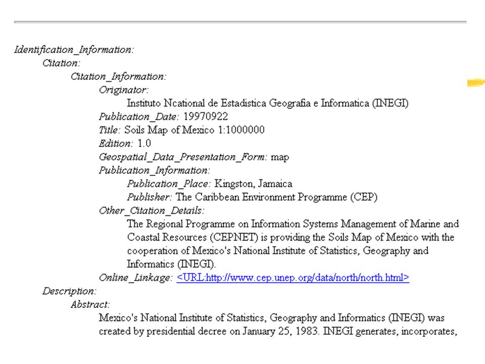
Metadata Solutions zNumerous software solutions available zCommercial and free-ware zStandalone, DB-linked, GIS-linked zPermit collection and structuring of FGDC- compatible metadata zPresent metadata as HTML, XML, or text

22
Server Solutions zZ39.50 Protocol is used z“GEO” Geospatial Metadata Profile is published for Z39.50 implementors to understand FGDC metadata structures zSupports search across numeric, text, date, and spatial extent and full-text zFreeware and commercial solutions

23
Gateway in more detail Nodes Gateway Web server interface Z39.50 clients Web Gateway Case Web client Web client

24
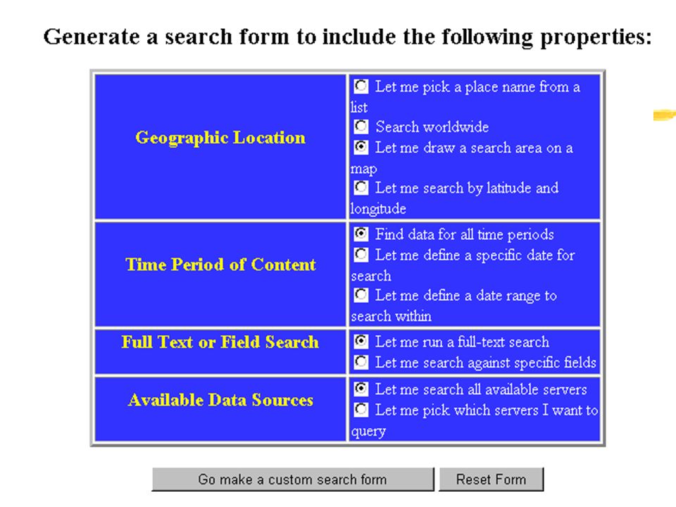
User Interfaces zHTML-based forms hosted at Gateways are the primary access method zJava map-based interface from MEL allows more sophisticated search zInclusion of search capabilities in GIS client software is possible

25
Who’s in Clearinghouse? z109 Nodes (servers) online as of 3/1/99 y28 Federal, national scope y35 State/University state-wide scope y28 International scope or location y18 Local or Regional scope
 online as of 3/1/99 y28 Federal, national scope y35 State/University state-wide scope y28 International scope or location y18 Local or Regional scope.")
26
Federal Participation zNOAA (10) zUSGS (6) zFEMA (sampler) zNRCS climate and soils zCIESIN/EPA zCIESIN/NASA zDOT NTAD z National Park Service z Army Corps of Engineers z Tri-Services Center z National Wetlands Inventory z Census (sampler) z Minerals Management Service
 zUSGS (6) zFEMA (sampler) zNRCS climate and soils zCIESIN/EPA zCIESIN/NASA zDOT NTAD z National Park Service z Army Corps of Engineers z Tri-Services Center z National Wetlands Inventory z Census (sampler) z Minerals Management Service")
27
State Participation zNew York (2) zNorth Carolina zOklahoma zKansas zTexas zMontana (3) zVermont zPennsylvania z West Virginia z Washington z Wisconsin z Wyoming (2) z Florida z Alabama z New Mexico z Arizona zGeorgia zIllinois zMinnesota zAlaska zCalifornia zDelaware zNebraska (2) zNew Jersey
 zNorth Carolina zOklahoma zKansas zTexas zMontana (3) zVermont zPennsylvania z West Virginia z Washington z Wisconsin z Wyoming (2) z Florida z Alabama z New Mexico z Arizona zGeorgia zIllinois zMinnesota zAlaska zCalifornia zDelaware zNebraska (2) zNew Jersey")
28
Regional/Local Participation zMcKinley Co, NM zCity of Santa Fe, NM zNorth Texas GIS zResearch Planning zSabine R Authority, TX zSan Francisco Bay zS Florida Ecosystem zSW Natural Resources z Olympic Peninsula, WA z Greater Yellowstone z Helena NF z Ecological Reserves, KS z MIT/Mass Boston DOQs z Great Lakes EIS z Eastern Sierra

29
International Participation zNOAA/Japan GOIN zSouth Africa (2) zESA AVHRR sampler zGELOS, Italy zPAIGH, Mexico zS57 Hydrography, Canada zNRL MEL zAfrica DDS z Inter-American Geospatial Data Network z Hong Kong z CIESIN/USDA Global Environmental Change z Australia (10+) z Costa Rica z Caribbean CEPNET, Jamaica
 zESA AVHRR sampler zGELOS, Italy zPAIGH, Mexico zS57 Hydrography, Canada zNRL MEL zAfrica DDS z Inter-American Geospatial Data Network z Hong Kong z CIESIN/USDA Global Environmental Change z Australia (10+) z Costa Rica z Caribbean CEPNET, Jamaica")
30
Planned or Funded Nodes zMt Desert Island, ME zSW Washington COG zNASA GCMD zCODEPLAN, Brazil zIowa zMissouri zKentucky z South Dakota z Oregon z Louisiana z Ohio z Connecticut MAGIC z Colorado z NW Ecosystems

31
88 Independent Nodes? NSDI One Common Access Method

32
For more information: Visit the FGDC website: http://www.fgdc.gov Contact the Clearinghouse Coordinator, Doug Nebert (ddnebert@usgs.gov)

Similar presentations


 Florida (FL) Georgia (GA) Mississippi (MS) Louisiana (LA) Arkansas (AR) Tennessee (TN)>")


