Download presentation
Presentation is loading. Please wait.

1
Cumbria Flood November 2009 NameDiane Jackson & David Snaith Job titleFlood Incident Management Team Date21 st June 2011

2
Cumbria Floods November 2009 Background Working with our partners at Strategic Co-ordination Group Community group working and Tactical Co-ordination

4
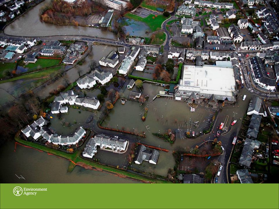
An Extreme Event of Unprecedented Scale… 316.4mm of rain fell in 24 hours – the UKs wettest day on record 1500 properties flooded across Cumbria River Derwent and River Cocker reached highest levels ever recorded In Cockermouth up to 200 people had to be evacuated Tragically a police officer lost his life No Environment Agencys defences in an urban areas failed Approximately 1500 properties were protected from flooding by agency assets

5
Impacts on Infrastructure 6 bridges collapsed 1800 bridges assessed 13 more closed; one condemned Telecomms services at risk Concern around reservoirs Water supply largely OK Waste water infrastructure OK Roads closed

6
Flood Forecasting The Flood Forecasting Centre issued flood guidance highlighting low risk on Sunday 15 th November and on Wednesday 18 th November this went to high risk of significant property flooding Flood Watches issued on Tuesday 17 th November Flood Warnings issued from Wednesday 18 th onwards

8
Strategic Co-ordination Group

9
Gold Control – Police HQ Police Fire and Rescue Services Health – Ambulance Service, HPA, NHS Councils – County and Local Authorities Military – Army, RAF Voluntary Agencies – Mountain Rescue, Red Cross Ultilities – UU, BT, Network Rail, Highways Sellafield MCA Met Office GONW Environment Agency

10
Information required at Strategic Flood Zone Maps Flood Warning Areas Maps Multi Agency Flood Plan Resources and equipment Urban myths Knowledge of local area Number of properties effected Waste Farming

12
Community Groups January 2005 & November 2009

14
January 2005 – No Knowledge of what to do when Flooded Where to evacuate too? Do they need to evacuate? Where is the high ground to move the car too? How long after receiving a warning will they be flooded? What kind of Help you might get from each Agency.

16
How Did We Start Working with residents from Keswick Briefed them what Flood Incident Management is about. Discussed such items as lead times and responsibilities. How best to involve the rest of the community. Keswick Flood Action Group established

17
Keswick Flood Action Group, local awareness and publicity Increased the number of people registered to receive warnings. Increased awareness of what services Agencies provide (lead time of warnings). Sub Groups set up to Identify different sources of flooding. (Adopt a drain group). Production of newsletters. Develop an Emergency Plan. Training for Group Leaders
. Sub Groups set up to Identify different sources of flooding. (Adopt a drain group). Production of newsletters. Develop an Emergency Plan. Training for Group Leaders.")
18
Emergency Plan

19
Environment Agency Issues Flood Watch via FWD (telephone warning system – heads up for community emergency team to check their e-mail) EA contacts KFAG:- With situation update KFAG to e-mail hourly updates to community emergency plan team following their assessment of the river and contact with the EA KFAG to monitor river. When it reaches 1.2m at High Hill KFAG will telephone team leaders of Lions Churches Together Flood Volunteers To assist with river monitoring When flood warning for Fitz Park & Riverside Flats is issued or when river reaches 1.5m Community Emergency Team to take over and Council Offices open How the community plan works Environment Agency Issues Flood Watch via FWD (telephone warning system – heads up for community emergency team to check their e-mails) EA contacts KFAG:- With situation update KFAG to e-mail hourly updates to community emergency plan team following their assessment of the river and contact with the EA KFAG to monitor river. When it reaches 1.2m at High Hill. KFAG will telephone team leaders of Lions, Churches Together, Flood Volunteers. To assist with river monitoring When flood warning for Fitz Park & Riverside Flats is issued or when river reaches 1.5m Community Emergency Team to take over and Council Offices open
 EA contacts KFAG:- With situation update KFAG to hourly updates to community emergency plan team following their assessment of the river and contact with the EA KFAG to monitor river. When it reaches 1.2m at High Hill. KFAG will telephone team leaders of Lions, Churches Together, Flood Volunteers. To assist with river monitoring When flood warning for Fitz Park & Riverside Flats is issued or when river reaches 1.5m Community Emergency Team to take over and Council Offices open.")
20
Environment Agency issue Flood Warning for Fitz Park & Riverside Flats Rest Centre Volunteers (WI & Churches Together) To open Keswick School and provide refreshments to volunteers and public Door knocking volunteers (Rotary and Lions) Door knocking to reinforce warning and to find out if any additional help is required Deployment Teams Sandbagging, flood products Filling and distributing sandbags & Inserting floodgates to properties Links to adjoining parishes Medical & Health Responders To administer first aid & Monitor health & wellbeing Keswick Emergency Co-ordinating Group (Council Offices) Information & Communication Team (based in Foyer) Pre set templates flooding information /flu info. Useful contact numbers/websites Media inc Keswick Reminder/radio Cumbria/Kesmail/KFAG newsletter Recovery – Keswick open for business Resources Voluntary Car Scheme Buses Generators Gas Stoves Sleeping Bags 4X4s & Tractors Keswick Tourism Association – Mountain Rescue Co-ordination of incident & recovery Fire / Police / EA (Forward control point) information role. Suggested contact to be made to control rooms. Action on the ground Flood Warning Cascade List Scouts have these And a hut that could be used as a rest centre Environment Agency Issues a Flood Warning Keswick Emergency Co-ordinating Group (Council Offices) Fire / Police / EA (Forward control point) information role. Suggested contact to be made to control rooms. Recovery – Keswick open for business Information & Communication Team Voluntary Car Buses 4X4s & Tractors Generators Gas Stoves Sleeping Bags Keswick Tourism Association – Mountain Rescue Rest Centre Volunteers Door Knocking to re-enforce Warning Deployment Teams Flood Products Sandbags Link to adjoining Parishes Medical Health Responders
 information role. Suggested contact to be made to control rooms. Action on the ground Flood Warning Cascade List Scouts have these And a hut that could be used as a rest centre Environment Agency Issues a Flood Warning Keswick Emergency Co-ordinating Group (Council Offices) Fire / Police / EA (Forward control point) information role. Suggested contact to be made to control rooms. Recovery – Keswick open for business Information & Communication Team Voluntary Car Buses 4X4s & Tractors Generators Gas Stoves Sleeping Bags Keswick Tourism Association – Mountain Rescue Rest Centre Volunteers Door Knocking to re-enforce Warning Deployment Teams Flood Products Sandbags Link to adjoining Parishes Medical Health Responders.")
21
Keswick Tactical Control Room – November 2009 Police Fire and Rescue Service North West Ambulance Service Environment Agency Keswick Mountain Rescue Team Town Council Keswick Flood Action Group (KFAG) Resilience Unit – intermittent presence Central location Sustained presence for 12 hours then recovery
 Resilience Unit – intermittent presence Central location Sustained presence for 12 hours then recovery")
22
Information Required at Tactical Weather forecasts Potential flood routes Timing of flooding/ overtopping/ locations/ extent/ river level Historical information – what happened in 2005 Urban myths – Thirlmere reservoir

23
What went well Preparation – emergency plan work Keswick Flood Action Group monitoring on the ground – regular contact Evacuation – timely using volunteers where appropriate Used experience of 2005 to highlight electricity issue Early decision of formal control room set up Regular meetings – information needed – all prepared Buddying EA/Fire/Police and community Group Forward Control Point at Town Hall Withdrawal of volunteers at appropriate time Coordination of reception centres – Town Council assisted Provision of food – welfare

24
High Hill flood defence wall Keswick

25
A quote from a Senior Cumbria Fire and Rescue Service Officer Many lives were saved due to the implementation of the Flood Plan Quote from Graham Thompson Chair of Keswick Flood Action Group I am proud to have been part of a coordinated response in which the community worked seamlessly with the emergency services and I am grateful to those many people who supported me

27
Thank you, any questions?

Similar presentations


 of Georgia.>")


, a government structure in the Ministry of Environment.>")