Download presentation
Presentation is loading. Please wait.

1
Utah’s Geospatial Partners Report Division of Archives & Automated Geographic Reference Center 1/23/2008

2
Utah’s Report Expectations of participating in this project; –Learn from partners –Leverage electronic records management business plan –Linkage with geospatial content –Identify and implement standards Existing linkages between the records retention and GIS communities –Inventory strategies and –Current geospatial archival capacity Governance and structure issues for both communities; and –State Records Committee and (GRAMA) retention schedule –Utah Geospatial Infrastructure (UGI) Strategic Plan Priority topics in the state communities –Criteria used –State and local business needs –Which data meets “Historical records” requirements –Identification and division of responsibilities –All state and local government
 retention schedule –Utah Geospatial Infrastructure (UGI) Strategic Plan Priority topics in the state communities –Criteria used –State and local business needs –Which data meets Historical records requirements –Identification and division of responsibilities –All state and local government")
3
History of GIS Coordination in Utah 1978 – Recommendations to create SGID 1981 – AGRC created 1987 – ESRI established as state GIS standard 1987 – GISAC established 1991 – SGID created in statute 1991 – UGIC created and held first conference 1994 – Canyon Country Partnership chartered 1998 – Data Sharing Agreement signed by Gov. 2001 – Framework Implementation Plan completed 2008 – State Geospatial Strategic Plan (pending)
.")
4
History of Data Archives in Utah 1969 – Division of Archives and Records Service established 1979 – State’s Information Practices Act Administration was transferred to the Archives 1983 – State Archives developed records management program in addition to an archives, to work with agencies to schedule and transfer records to the Archives 1992 – Government Records Access and Management Act –State Records Committee approves all retentions 2002 – Began developing electronic records guidelines 2008 – Legislature funds Electronic Records Management and Preservation Business Plan

5
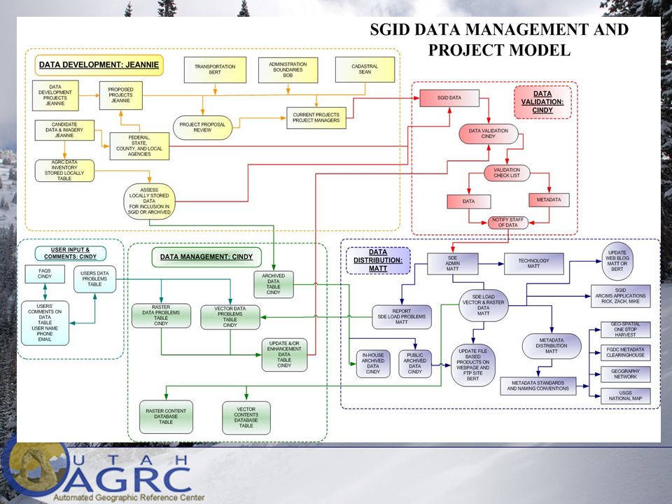
State Agencies CitiesCities Public & Orgs. TribesTribes Federal Agencies CountiesCounties A foundation exists for a statewide approach to develop, maintain, and share geographic data AGRC DATA SHARING: Utah’s SGID State Geographic Information Database GISAC

6
Categories contained in the SGID Transportation Cultural / Historical Demographic Environmental Geology / Soils Land Ownership/Use Cities & Service Districts Place Names Political Boundaries Scanned Maps Aerial Photography Utilities Vegetation Water Wilderness Areas & Proposals

7
NAIP (one meter)High Res (one foot)
High Res (one foot)")
8
Municipal Boundary Data Changes

9
Enterprise GIS: Utah’s Cadastral Infrastructure PLSS, Boundaries, Parcels Statewide Parcel Data Model –Boundary, Parcel ID, Address, Owner Type, County Contact Data Acquisition, Access Strategy Multiple entities’ data is integrated

12
EPA AGRC & SGID AGRC & SGID Utah Spatial Data Infrastructure Utah Spatial Data Infrastructure Agric. BoR BLM FS USGS Census F&WS NRCS Tribal Governments DHS UGIC State Agencies NPS GOPB Tax DEQ UDOT DNR Federal Agencies Universities GPSAC SMAC UCGN TIG Regional User Groups Affiliate Organizations County and City Governments GISAC Coordination Organizations

Similar presentations
 Fifty States Initiative USGS Cooperative Agreement Partnership.>")
 Data Committee (3) Elevation Elevation Hydrography Hydrography Land Records Modernization Land Records Modernization.>")

 Circular A-16 Supplemental Guidance, is the coordination of Federal geospatial.>")


