Download presentation
Presentation is loading. Please wait.

1
Water Systems The Water Cycle, Streams, and Ground Water

2
Earth’s Water Supply

3
Water Cycle movement of water between the atmosphere, the land, and the oceans.

4
Evaporation Water changing from liquid phase to a gaseous phase(water vapor) without boiling. Surface 2/3 Water 500,000 km 3 /year Evapotranspiration – evaporation from plant leaves.

5
Condensation change of state from a gas to a liquid When water vapor rises in the atmosphere, it expands and cools. As the vapor becomes cooler; some of it condenses back to liquid High – Clouds Low – Fog Surface - Dew

6
Precipitation Any form of water that falls to Earth’s surface (rain, snow, sleet, and hail) Most precipitation falls on Earth’s oceans. The rest falls on land and becomes runoff or infiltrates the soil to become groundwater.

8
Runoff Rain that falls to the ground and is not absorbed Moves along the surface of the land until it flows into a stream system Causes erosion.

9
Factors Affecting Runoff Rate of rain Runoff Slope Runoff Buildings Runoff Plants Runoff

10
River Systems watershed (AKA basin) the area of land that is drained by a river system The ridges or elevated regions that separate watersheds are called divides. tributaries streams that flows into a lake or into a larger stream A river system is made up of a main stream and tributaries.

12
Mississippi River Basin

13
Moosehead Lake Watershed Contains: 31 lakes 549 m 2 of land 400 miles of rivers and streams empties out into the Atlantic Ocean

14
River Systems Channel - Depression that a stream follows as it flows downhill Banks - The edges of a stream channel that are above water level Bed - The part of the stream channel that is below the water level A stream channel gradually becomes wider and deeper as it erodes its banks and bed.

15
River Systems stream load - Sediment carried by a stream Stream load takes three forms –suspended load –bed load –dissolved load

16
Stream Load

17
River Systems Stream gradient the change in elevation over a given distance Near the headwaters, or the beginning of a stream, the gradient generally is steep. As the stream nears its mouth, its gradient often becomes flatter. The characteristics of streams with different gradients are very different

18
Gradient

21
River Systems River systems change continuously because of erosion. Depending on the slope of the land, streams have three stages of development. Young, Mature, and Old These differing streams support different types of organisms

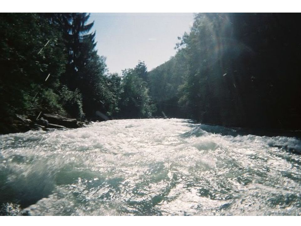
22
Young Streams Flow swiftly through a steep valley. Lots of whitewater and waterfalls because they have not yet eroded all the material in their way. Young streams erode most on the bottom and less on the sides.

23
Qualities Fast Moving High oxygen Cold Little Nutrients

26
Stream Merging Many young streams join together to form larger streams. Depending on the slope of the land and the amount of water they will form either mature or old streams

27
Mature and Old Streams Mature and Old Streams flow through floodplains. floodplain an area along a river that forms from sediments deposited when the river overflows its banks Occurs when water levels increase depending on the amount of rainfall and snowmelt in the watershed.

28
Floodplains

29
Mature Streams Curving streams that flow down a gradual slope Erode more on their sides than on the bottom. This leads to the creation of meanders (curves in a stream)
.")
30
Qualities Lots of sediment/nutrients –Erosion from young streams Slow moving –Algae can grow

31
Evolution of Mature Streams meander When a river rounds a bend, the velocity of the water on the outside of the curve increases. –Increase erosion On the inside of the curve, the velocity of the water decreases. –Increased deposition Causes curves to widen

32
Stream Flow

35
Horseshoe Bend of the Colorado River near Page, AZ

36
Oxbow Lakes The curve enlarges while further erosion takes place on the opposite bank, where the water is moving more quickly. Meanders can become so curved that they almost form a loop, separated by only a narrow neck of land This can eventually become separated into an oxbow lake

41
Old Streams Old streams flow very slowly through a broad flat floodplain. Usually they have lost their meanders and flow more straightly.

42
Deltas and Alluvial Fans Fan-shaped masses of sediment deposited as a stream slows Deltas occur where streams meet oceans Alluvial fans result where streams loose energy as the slope decreases rapidly.

46
Groundwater Water that absorbs into the ground and is located in the spaces between sediments (pores) These pores are connected and allow water to flow through them.
 These pores are connected and allow water to flow through them.")
48
Permeability Ability of a material(rock/sediment) to allow water to flow through it. Permeable rock/sediment layers allow water to pass through easily Impermeable rock/sediment layers resist the flow of water. Depends on size and shape of sediment

49
Zone of Saturation Ground water fills the pores in the permeable rock/sediment layer creating an aquifer. The area of the soil where all of the pores have completely filled with water is referred to as the zone of saturation. The upper limit of this zone is called the water table.

51
Wells Holes that are dug below the water table. Water has been filtered by sediment. If water table drops (drought) it can dry up the well. Too many wells in one area can also lower the water table
 it can dry up the well. Too many wells in one area can also lower the water table.")
53
Artesian Wells Special kind of well where water is pushed up to the surface naturally. Require a special kind of geography where an aquifer is sandwiched between impermeable layers and the layers change in elevation. Gravity creates pressure that forces water up artesian wells.

55
Springs Springs can exist where the groundwater reaches the surface Some times cracks allow natural artesian wells to form. Freshwater springs exist along coasts where fresh ground water enters the ocean.

60
Hot Springs and Geysers Occur where groundwater is stored near hot rocks Hot springs - near boiling water leaks up to the surface. Geysers - boiling water and steam is periodically released causing a stream of hot water to shoot out of the ground.

64
Caves and Sinkholes Form as carbonic acid dissolves limestone. Caves are structurally stable and do no collapse. If soil above a cave is weak and it collapses into a sinkhole. People pumping water out can turn caves into sink holes

66
Stalactites and Stalagmites Little CO 2 in caves, carbonic acid breaks down, can’t hold dissolved limestone. Limestone accumulates as water drips Stalactite - ceiling of the cave Stalagmite - ground of the cave

70
Adaptations Animals must have special adaptations to deal with living in a cave Dark No plants Wet Dangerous Chemicals

Similar presentations