Download presentation
Presentation is loading. Please wait.

1
NAVIGATION TRAINING Section 6 Navigational Aids

2
Section 1Types of Navigation Section 2 Terrestial Coordinates Section 3 Charts Section 4 Compass Section 5 Nautical Publications Section 6 Navigational Aids Section 7 Buoyage Section 8 Position Lines and Fixes Section 9 Tides Section 10 Currents Section 11 Weather Table of Contents

3
Navigational Aids Navigational Aid: Any device external to a vessel or aircraft intended to assist in determining position and safe course, or to warn of dangers or obstructions. Significance of Navigational Aids

4
Navigational Aids Navigational aids will include: Lighthouses Transit Marks Leading Lines Buoyage Beacons & Day Marks Identifiable charted object Navigational Aids

5
Positive Identification of Navigation Aids Phase characteristic Period & Colour Location Shape Colour Scheme Auxiliary features Special Markings DAYTIMENIGHT Navigational Aids

6
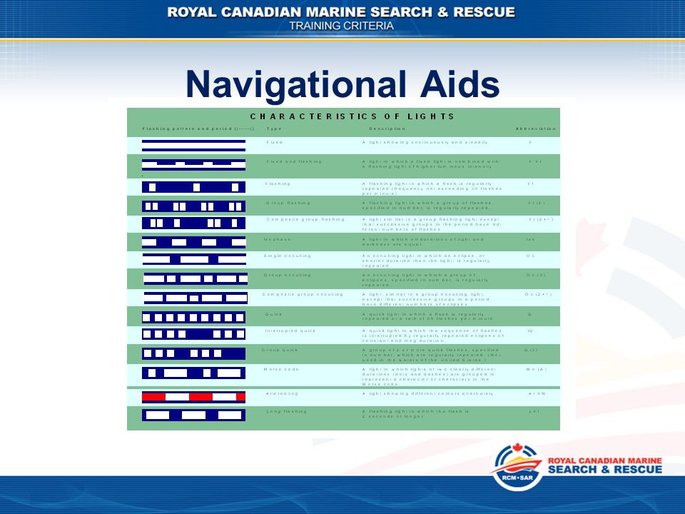
Positive Identification of Navigation Aids (at night) Navigational Aids
 Navigational Aids")
7
Positive Identification of Navigation Aids (at night) Period = Length in seconds of repetition Colour= (red, green, yellow, or white) Navigational Aids
 Period = Length in seconds of repetition Colour= (red, green, yellow, or white) Navigational Aids")
9
Special Purpose Lights Sector Lights Red light used in dangerous sectors Sector limits are expressed in degrees true as observed from a vessel, not from the light! Navigational Aids

10
Other Navigational Aids Other navigational aids, providing they are charted, will include: Navigational Aids

11
Navigation Marks and Buoyage Navigational Aids

12
Determining the Computed Visibility of a NavAid Horizon distance = the line of sight from a position above the earth’s surface to the visual horizon. Geographic range = the maximum distance that a light may be seen in perfect visibility by an observer’s eye who is at sea level Bella Navigational Aids

13
Determining the Computed Visibility of a NavAid Computed range = the distance at which a light could be seen in perfect visibility (taking into account elevation, observer’s height of eye, and the curvature of the earth). Computed Range = Horizon Distance + Geographic Distance Bella Navigational Aids

14
Determining the Computed Visibility of a NavAid Computed range = the distance at which a light could be seen in perfect visibility (taking into account elevation, observer’s height of eye, and the curvature of the earth). Computed Range = Horizon Distance + Geographic Distance Navigational Aids

15
Determining the Computed Visibility of a NavAid Computed visibility = The maximum distance at which a light can be seen in the current meteorological conditions. Luminous range = the maximum distance at which a light may be seen under under the current meteorological conditions. Nominal range = a special case of the luminous range. It is the distance a light could be seen in “clear” weather. Also called the charted range. Navigational Aids

Similar presentations