Download presentation
Presentation is loading. Please wait.

1
National Weather Service Weather Forecast Office Mobile - Pensacola Special Update Briefing Tropical Storm Karen Special Update Briefing Tropical Storm Karen 11 AM CDT Friday 4 October 2013

2
This outlook is intended for interests across interior southeast Mississippi, south Alabama, the western Florida Panhandle, and the adjacent Gulf coastal waters of Alabama and northwest Florida

3
Current Pattern

4
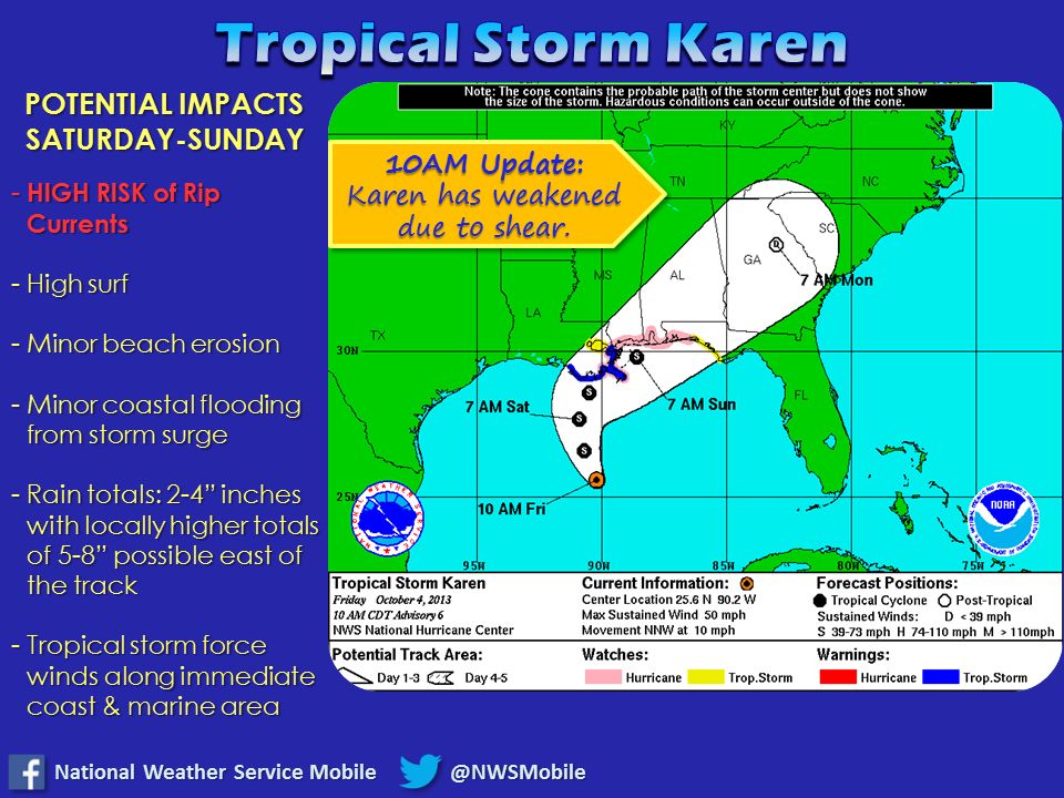
Current Situation with Karen Karen still struggling a bit with drier air aloft and wind shear. Intensity dropped back to 50 mph on the 10 AM update. Some minor strengthening is forecast over the next day as it starts to turn northeast.

7
Key Points At This Hour Karen is still battling some wind shear and dry air right now. The environmental window for Karen to significantly strengthen to a hurricane is starting to close. Some strengthening is expected over the next 24 hours based on what we see right now…but the environment is less conducive for rapid significant development. Hurricane Watch is still in effect along the coast. That will be re- evaluated this afternoon by NWS forecasters and may be replaced with a Tropical Storm Watch if current trends hold and no rapid strengthening is seen or forecasted. Stay tuned this afternoon for the latest information on that. The timing of the cold front moving in from the northwest will complicate exactly where Karen makes landfall and how strong it will be at landfall. Still a low confidence forecast on exactly where Karen will make landfall. Expect additional shifts in the track. Karen is still battling some wind shear and dry air right now. The environmental window for Karen to significantly strengthen to a hurricane is starting to close. Some strengthening is expected over the next 24 hours based on what we see right now…but the environment is less conducive for rapid significant development. Hurricane Watch is still in effect along the coast. That will be re- evaluated this afternoon by NWS forecasters and may be replaced with a Tropical Storm Watch if current trends hold and no rapid strengthening is seen or forecasted. Stay tuned this afternoon for the latest information on that. The timing of the cold front moving in from the northwest will complicate exactly where Karen makes landfall and how strong it will be at landfall. Still a low confidence forecast on exactly where Karen will make landfall. Expect additional shifts in the track.

8
Hurricane Watch in Effect

9
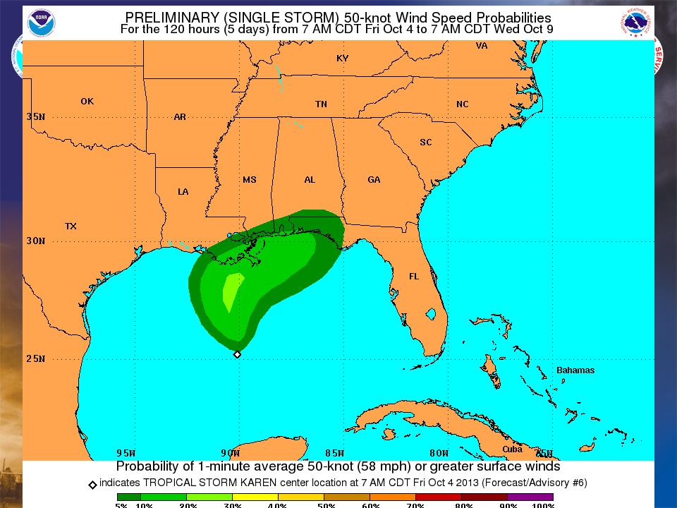
Hurricane force wind probabilities less than 5 %

12
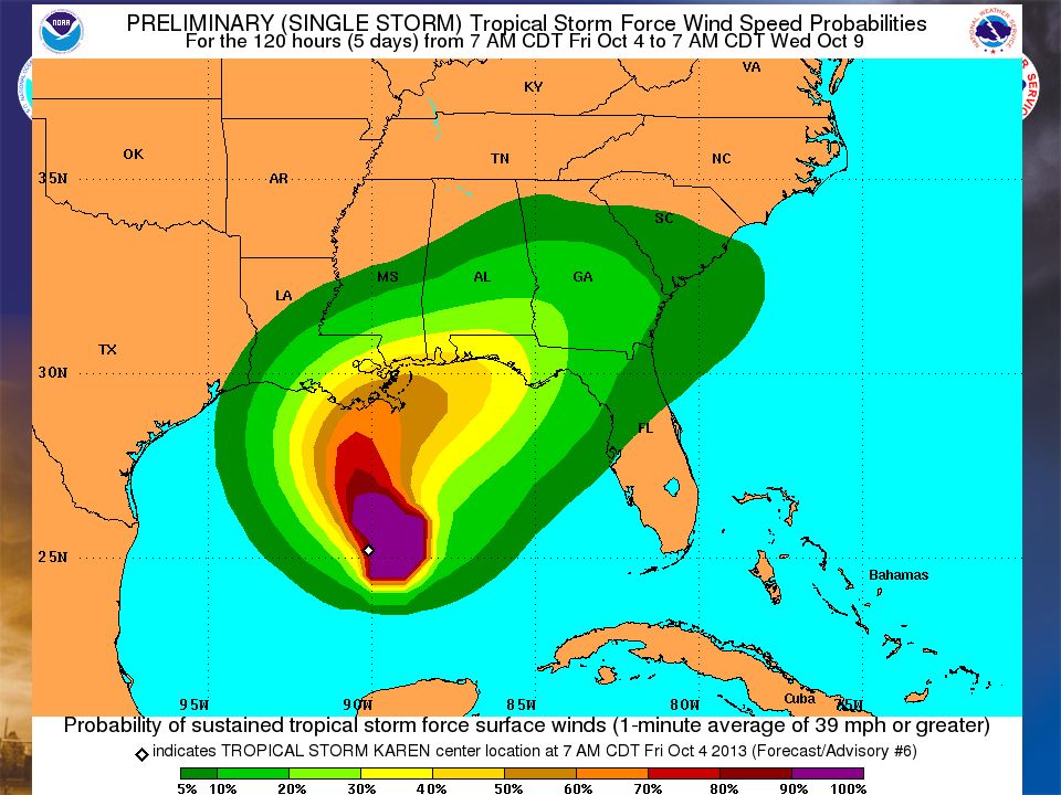
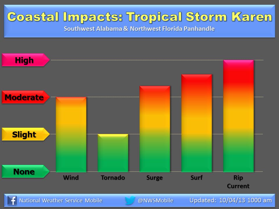
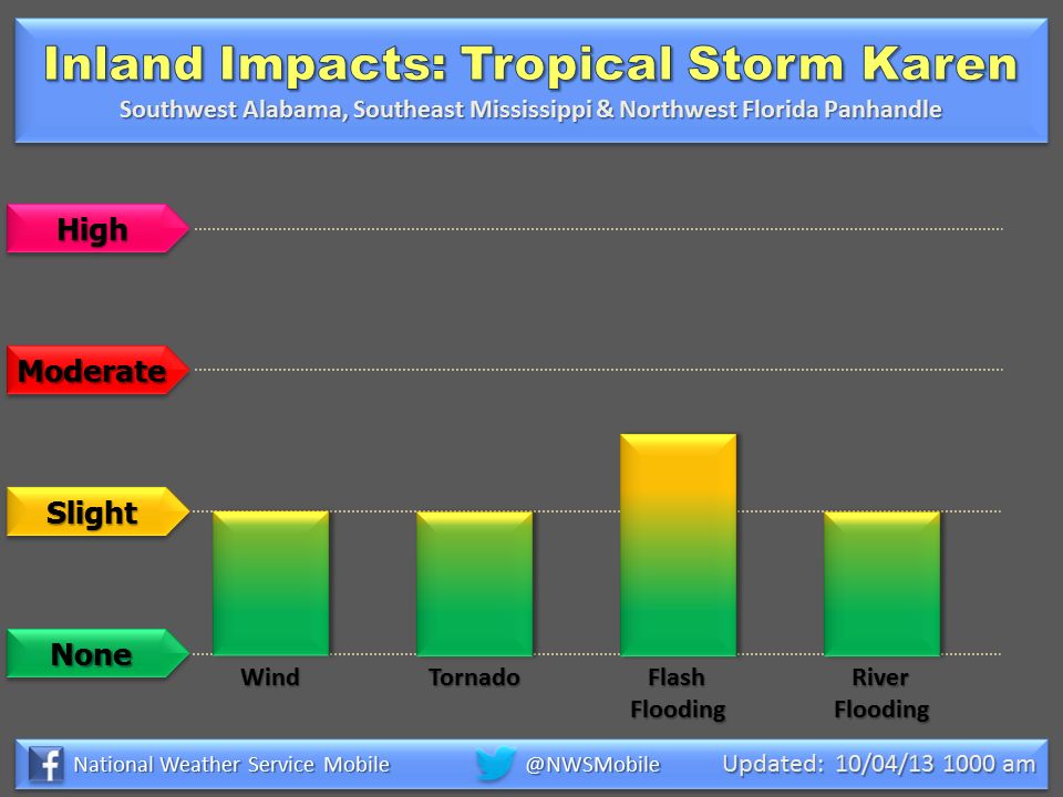
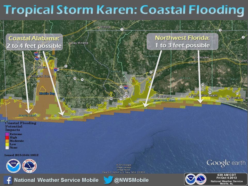
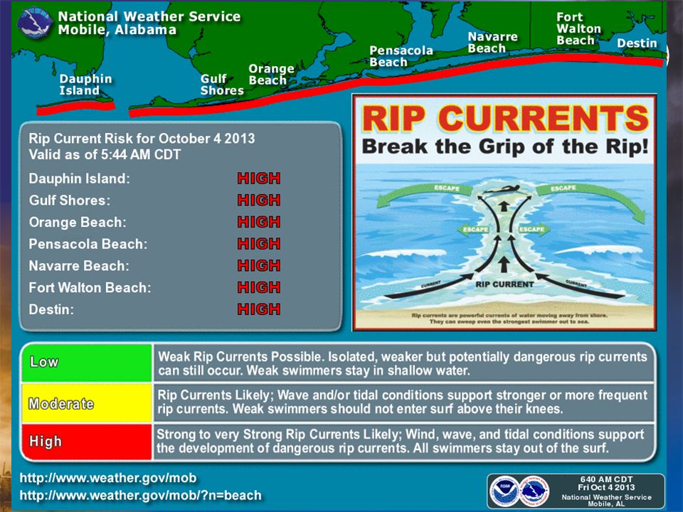
Potential Impacts Heavy Rainfall: 2 to 4 inches Friday through Sunday with locally higher amounts 4 to 8 inches possible. Heaviest rainfall will be near the coast. –Mostly flooding of poor drainage areas and smaller stream basins. –Shoal Creek in Florida currently at action stage…only larger river system right now of concern that possibly could approach minor flood stage. Wind Impacts: 40 to 50 mph winds (35 to 45 kts) possible over the marine area late Saturday night into early Sunday morning…especially in squalls with bands of thunderstorms. Tropical storm force winds at the coast Sunday morning. This is slower in timing than previous forecasts. Coastal Flooding…Storm Surge and Tide Levels: Stronger East to Southeast winds late Saturday into Sunday could produce 3 to 4 feet inundation flooding over land…mainly Alabama Coast and westward. 1 to 3 feet inundation over the western Florida Panhandle. Astronomical high tide is during the evening hours. –First to Flood: starting early Saturday Morning…Dauphin Island…Mobile Causeway…Fort Pickens. Beaches: Expect a HIGH RISK FOR DANGEROUS RIP CURRENTS through Sunday. Also beach erosion with higher wave run-up possible through Sunday. High tide for this event will be during the evening hours. Heavy Rainfall: 2 to 4 inches Friday through Sunday with locally higher amounts 4 to 8 inches possible. Heaviest rainfall will be near the coast. –Mostly flooding of poor drainage areas and smaller stream basins. –Shoal Creek in Florida currently at action stage…only larger river system right now of concern that possibly could approach minor flood stage. Wind Impacts: 40 to 50 mph winds (35 to 45 kts) possible over the marine area late Saturday night into early Sunday morning…especially in squalls with bands of thunderstorms. Tropical storm force winds at the coast Sunday morning. This is slower in timing than previous forecasts. Coastal Flooding…Storm Surge and Tide Levels: Stronger East to Southeast winds late Saturday into Sunday could produce 3 to 4 feet inundation flooding over land…mainly Alabama Coast and westward. 1 to 3 feet inundation over the western Florida Panhandle. Astronomical high tide is during the evening hours. –First to Flood: starting early Saturday Morning…Dauphin Island…Mobile Causeway…Fort Pickens. Beaches: Expect a HIGH RISK FOR DANGEROUS RIP CURRENTS through Sunday. Also beach erosion with higher wave run-up possible through Sunday. High tide for this event will be during the evening hours.
 possible over the marine area late Saturday night into early Sunday morning…especially in squalls with bands of thunderstorms. Tropical storm force winds at the coast Sunday morning. This is slower in timing than previous forecasts. Coastal Flooding…Storm Surge and Tide Levels: Stronger East to Southeast winds late Saturday into Sunday could produce 3 to 4 feet inundation flooding over land…mainly Alabama Coast and westward. 1 to 3 feet inundation over the western Florida Panhandle. Astronomical high tide is during the evening hours. –First to Flood: starting early Saturday Morning…Dauphin Island…Mobile Causeway…Fort Pickens. Beaches: Expect a HIGH RISK FOR DANGEROUS RIP CURRENTS through Sunday. Also beach erosion with higher wave run-up possible through Sunday. High tide for this event will be during the evening hours. Heavy Rainfall: 2 to 4 inches Friday through Sunday with locally higher amounts 4 to 8 inches possible. Heaviest rainfall will be near the coast. –Mostly flooding of poor drainage areas and smaller stream basins. –Shoal Creek in Florida currently at action stage…only larger river system right now of concern that possibly could approach minor flood stage. Wind Impacts: 40 to 50 mph winds (35 to 45 kts) possible over the marine area late Saturday night into early Sunday morning…especially in squalls with bands of thunderstorms. Tropical storm force winds at the coast Sunday morning. This is slower in timing than previous forecasts. Coastal Flooding…Storm Surge and Tide Levels: Stronger East to Southeast winds late Saturday into Sunday could produce 3 to 4 feet inundation flooding over land…mainly Alabama Coast and westward. 1 to 3 feet inundation over the western Florida Panhandle. Astronomical high tide is during the evening hours. –First to Flood: starting early Saturday Morning…Dauphin Island…Mobile Causeway…Fort Pickens. Beaches: Expect a HIGH RISK FOR DANGEROUS RIP CURRENTS through Sunday. Also beach erosion with higher wave run-up possible through Sunday. High tide for this event will be during the evening hours..")
16
Storm Surge Probabilities… Storm Surge Probabilities Greater than 2 Feet Inundation

19
Expected Rainfall Amounts: 2 to 4 inches possible Friday through Sunday with locally higher amounts of 4 to 8 inches possible. Heaviest rainfall will be near the coast. Impacts: Most flooding will be in smaller stream basins and poor drainage areas. Larger basin main-stem river flooding expected to be minor. Amounts and impacts will heavily depend on track and strength Saturday into Sunday.

20
Tropical Storm Force Winds (39-73 mph in squalls) moving up across SE Louisiana. This track could change…speed up…or be shifted east or west. Tropical Storm Force Winds (39-73 mph in squalls) moving up across SE Louisiana. This track could change…speed up…or be shifted east or west. Wind Threats Timing – 3 PM Saturday 39-57 mph 57-73 mph
 moving up across SE Louisiana. This track could change…speed up…or be shifted east or west. Wind Threats Timing – 3 PM Saturday mph mph.")
21
Tropical Storm Force Winds (39-73 mph in squalls) would be approaching the offshore coastal waters of Alabama. This track could change…speed up…or be shifted east or west. Tropical Storm Force Winds (39-73 mph in squalls) would be approaching the offshore coastal waters of Alabama. This track could change…speed up…or be shifted east or west. Wind Threats Timing – 9 PM Saturday 39-57 mph 57-73 mph
 would be approaching the offshore coastal waters of Alabama. This track could change…speed up…or be shifted east or west. Wind Threats Timing – 9 PM Saturday mph mph.")
22
Tropical Storm Force Winds (39-73 mph in squalls) would begin impacting the coastal counties of Alabama…and the western Florida Panhandle toward daybreak. This track could change…slow down…or be shifted east or west. Tropical Storm Force Winds (39-73 mph in squalls) would begin impacting the coastal counties of Alabama…and the western Florida Panhandle toward daybreak. This track could change…slow down…or be shifted east or west. Wind Threats Timing – 3 AM Sunday 39-57 mph 57-73 mph
 would begin impacting the coastal counties of Alabama…and the western Florida Panhandle toward daybreak. This track could change…slow down…or be shifted east or west. Wind Threats Timing – 3 AM Sunday mph mph.")
23
Tropical Storm Force Winds (39-73 mph in squalls) would be impacting SW Alabama and the Western Florida Panhandle. This track could change…slow down…or be shifted east or west. Tropical Storm Force Winds (39-73 mph in squalls) would be impacting SW Alabama and the Western Florida Panhandle. This track could change…slow down…or be shifted east or west. Wind Threats Timing – 9 AM Sunday 39-57 mph 57-73 mph
 would be impacting SW Alabama and the Western Florida Panhandle. This track could change…slow down…or be shifted east or west. Wind Threats Timing – 9 AM Sunday mph mph.")
24
Tropical Storm Force Winds (39-73 mph in squalls) may be diminishing across SE Mississippi and coastal Alabama…but may be ongoing across South Central Alabama and the Western Florida Panhandle. This track could change…slow down or be shifted east or west. Tropical Storm Force Winds (39-73 mph in squalls) may be diminishing across SE Mississippi and coastal Alabama…but may be ongoing across South Central Alabama and the Western Florida Panhandle. This track could change…slow down or be shifted east or west. Wind Threats Timing – 3 PM Sunday 39-57 mph 57-73 mph
 may be diminishing across SE Mississippi and coastal Alabama…but may be ongoing across South Central Alabama and the Western Florida Panhandle. This track could change…slow down or be shifted east or west. Wind Threats Timing – 3 PM Sunday mph mph.")
25
Tropical Storm Force Winds (39-73 mph in squalls) may begin diminishing across South Central Alabama and the Western Florida Panhandle. This track could change…slow down or be shifted east or west. Tropical Storm Force Winds (39-73 mph in squalls) may begin diminishing across South Central Alabama and the Western Florida Panhandle. This track could change…slow down or be shifted east or west. Wind Threats Timing – 9 PM Sunday 39-57 mph
 may begin diminishing across South Central Alabama and the Western Florida Panhandle. This track could change…slow down or be shifted east or west. Wind Threats Timing – 9 PM Sunday mph.")
26
Cumulative Wind Threats Late Saturday – Early Sunday NOTE…This track could change and be shifted east or west. This is just to demonstrate how far inland we think the wind impacts could spread.

Similar presentations


>")


 CONFERENCE CALL Wednesday 2:30 PM February 6, 2013.>")

